In early 2019, I gave a talk to the Aldridge 41 club ( a group of retired Rotarians) entitled the Earl of Dudley’s Railway – i.e. the Kingswinford and Pensnett Railways. Most of the material I used was easily available in books or on the web, but I did draw some sketch maps to show how the railway developed and declined over its 150 year life. These maps provided a quite striking way of looking at the railway, and it seemed worthwhile to add a little detail to them and reproduce them here – see below. Before considering them further a health warning or two is required. First these maps were produced for a presentation and thus their cartographic accuracy is not great; secondly the information they contain has been culled from a variety of sources, particularly maps of different sorts. Even the best of these (OS) can sometimes show features that ceased to exists some time before the map was produced, and these anachronisms may well have been reproduced below. That being said, let us consider these maps one by one.


- The 1780 map shows the towns of Dudley, Stourbridge and Kingswinford as three red circles, that will appear on all the following maps. The only form of large scale transport at that time was the Staffordshire and Worcestershire Canal in the western boundary of the map.
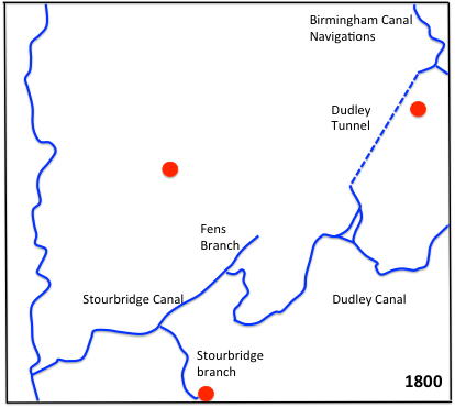
- By 1800 the local canal system had begun to develop and the Stourbridge and Dudley canals formed a link between the Staffordshire and Worcestershire canal and the Birmingham Canal Navigations in the north east, via the Dudley tunnel. These served a range of extractive and heavy industries in the region close to the canals.
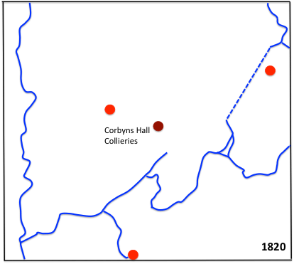
- Little had changed in transport terms by 1820, but coalminers were being developed in the area around Corbyn’s Hall to the north of the Stourbridge canal. These mines and the associated industries were to drive much of the future development.
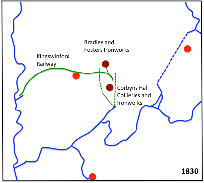
- The 1830 map shows the newly opened Kingswinford Railway from Ashwood Basin on the Staffs and Worcs (shown as a solid green line) to the iron works and collieries in the centre of the map. A number of tramways (shown as dotted green lines) to transport coal and iron products to the canal were also in existence. The tramways are only shown in outline – the system was considerably more extensive and detailed than could be included here.
- 1840 saw the opening of the Stourbridge Extension canal from the Fens branch of the Stourbridge canal to the Oak Farm area. The Pensnett Canal, a short branch from the Dudley tunnel entrance to the Round Oak area, had also been constructed.
- By 1850 the Round Oak Iron Works was in production and the first lines of the Pensnett Railway had been constructed to supply the works with coal.
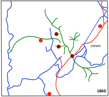
- By 1860 the Pensnett Railway had developed considerably, with a network centred on Round Oak extending both north and south. Main line railways had reached the area with the opening of the OWWR line between Stourbridge, Dudley and Wolverhampton. This connected at Dudley with the southern end of the South Staffordshire Railway, and also had short branch to the Stourbridge canal at Bromley.
- Mainline railway developments continued and by 1870, the Stourbridge Railway had been built (later to be taken over by the GWR) and the Bromley brain of the OWWR had been extended to Kingswinford and beyond. The Pensnett Railway continued to grow and a connection had been made between the Pensnett and Kingswinford lines.
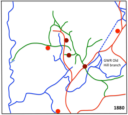
- The situation was similar in 1880, with the only development in the area being the GWR Dudley to Old Hill branch. At this time there was a very extensive internal railway system at the Bradley Iron works that is not shown on the map.
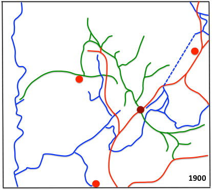
- By 1900 the Pensnett Railway had changed somewhat, with branches to now dissed collieries being shut and new branches being opened. The longest of these, to Dibble in Gornal, was actually owned by Ben Gibbons and was not a formal part of the Pensnett Railway.
- New lines continued to be built and by 1920 we can see the GWR Wombourne brach from Kingswinford to Wolverhampton (which briefly included a passenger service) and the final Pensnett Railway extension to Baggeridge Colliery in the north of the picture. By this time the eastern end of the original Kingswinford Railway had been truncated.
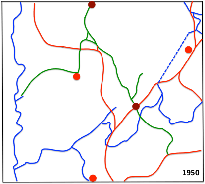
- The decline of industry in the area saw the decline of the transport network and by 1950 the Stourbridge Extension canal and the Pensnett Canal had been abandoned, and most of the Pensnett Railway branch lines had met similar fate.
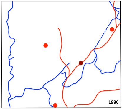
- The situation was even more stark by 1980, with the Pensnett Railway reduced to an internal works railway at Round Oak, and the main line Wombourne branch beings truncated at Kingswinford and the Old Hill branch having been closed.
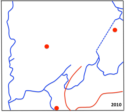
- The current situation is shown in the 2010 map. The Kingswinford branch and the main line north of Round Oak has been closed, and the only railway in the area is the Stourbridge to Birmingham line in the south.
- There are however possibilities of reopening, as shown in the 2030 map. There is sporadic discussion of reopening the line between Stourbridge, Dudley and Walsall primarily s a heavy freight diversionary route. There are more concrete proposals for using the trackbed of the line from Wednesbury to Dudley for a branch of the Midland Metro tram system, with street running from there, through Dudley town and on to Merry Hill and Brierley Hill. At the time of writing preliminary works on this line are underway.
One other point is worthy of mention. For the sake of clarity I have not included the street tramways of the area on these maps. These had quite short lifetimes, with a steam operated line between Dudley and Stourbridge opening in the 1880s, which eventually became a linked system of electric tramway connecting Dudley, Stourbridge, Kinver, Kingswinford and Old Hill and Cradley Heath. These were all to close in the 1920s.

Great article! Must have taken a lot of research to come up with these dates and maps. I noticed a slight error in the map. South of the South end of the Dudley canal tunnel there is no longer a “triangular” set of canals – just two spurs from the tunnel. So at some time the E-W short route between the two spurs was filled in (if you look at Google Earth there is evidence that it justed to be there, but the cancal now covered by factories). Just thought you might like to know. Thanks again for a gerat article! Tony
LikeLike
Thanks for this – function of copying and pasting I’m afraid. I will leave it as it is for the moment, with this comment to alert readers, but at some stage I will alter the pictures. Thanks again
LikeLike
Changes made – they were quite straightforward. Looking at various maps, it seems that the Two Locks Line (as that section of the canal was called) went out fuse in the 1920s/ 1930s. Thanks again for spotting this.
LikeLike
You are more than welcome. Two Locks Line – nice name! I can see it now as named on a 1914 OS map. BTW, I believe there was a short canal opposite the glass cone in Worsdley that went to the old Webbs Seeds Factory. You can see that on the 1914 map and today there is a bridge over that old short section (but its long been flled in).
LikeLike
How did miners from the Kingswinford area get to work at Bagerridge minesite in the 1950s were they picked up by company bus?
LikeLike
Sorry for the delay in replying – I have been on holiday. But I fear the answer is that I don’t know. cars weren’t so common around then for industrial workers, so I suspect there must have been some sort of transport to the site.
LikeLike