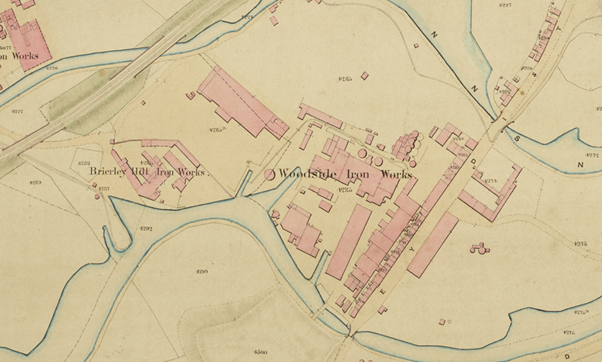

The Engraving
Woodside Iron Works, was founded in 1840 by Alexander Brodie Cochrane and his son Charles Cochrane. It became very well known and respected and produced components for many significant structures, including girders for the Runcorn Bridge over the River Mersey and the Farringdon Street Viaduct in London; ironwork for the Rochester Road Bridge, the Swing Bridge over the River Medway and the Clifton Suspension Bridge; and a wrought iron bridge for New Street Railway Station in Birmingham
Now I recently paid for a license from Dudley Archives for the use of the engraving of the works shown in Figure 1 below, for use in a blog post and in a forthcoming article in the Blackcountryman based on that blog post. It is catalogued as Woodside Iron Works c 1860. In the blog post and article, I used it to illustrate accounts of the works found in my great grandfather’s diaries and did not discuss it to any extent. It really does however deserve somewhat greater consideration, and so in this post, I will consider it in somewhat greater detail.
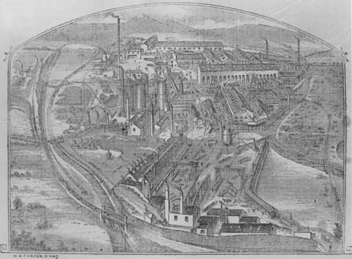
Figure 1. Woodside Iron Works c1860
Major Features
So what does the engraving actually show? Figure 2 shows a comparison between the engraving and a map of Dudley from 1857. Note that north on the map is around 20 degrees clockwise from the map vertical axis. On both the engraving and the map, the main line of the Oxford, Worcester and Wolverhampton Railway can be seen , with the engraving also showing a siding into the works. The Dudley Canal can be seen on both engraving and map (heading for Dudley Tunnel in the distance) with Lord Ward’s Pensnett Canal also visible, heading to a junction with the Dudley Canal just south of Dudley Tunnel. Two railway bridges, over the Pensnett Canal and a road are shown at A and B on both. In the distance can be seen the Netherton ridge and Netherton church. The likely vantage point from which the initial sketch for engraving was made is shown by the red circle on the map.
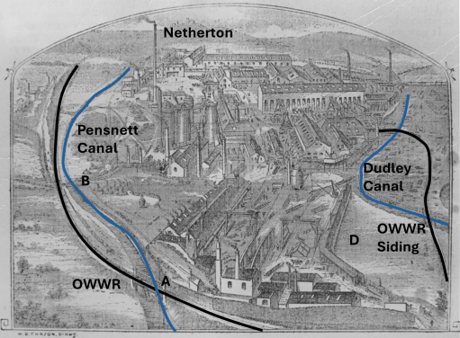
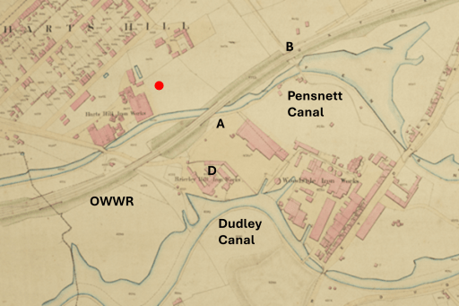
Figure 2. Comparison between the engraving anda map of 1857
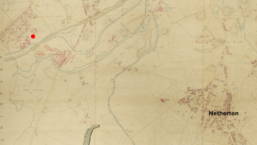
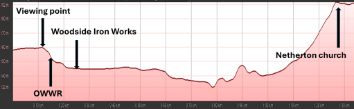
Figure 3a shows a smaller scale version of the map of figure 2 so that the relationship can be seen between the Iron Works (and the vantage point from which it was sketched) and Netherton in the far distance on the engraving. Figure 3b shows an elevation profile along a line through the vantage point and Netherton church. It can be seen that there is an initials steep drop from the vantage point across the railway to the Iron Works, and the ground then remains fairly level until the steep slope up to the Netherton ridge is reached. Thus the view of the iron works shown on the engraving, with a perspective indicating that it was painted from an elevated position, is a real one.
(a)
(b)
Figure 3. The Iron Works in the wider landscape.
The date of the engraving
The Archive catalogue gives the date of the engraving as c1860, but can a more precise date be determined? The Iron Works themselves had opened in the 1840s, but the main line of the Oxford, Worcester and Wolverhampton Railway wasn’t opened intill November 1852, so that gives the earliest possible date for the engraving. The Brierley Hill Iron Works (D on the map of figure 2) was also operational from the 1840s, but oddly does not appear on the engraving. Or rather only the angular building that marks the northern edge of the works is shown. I am inclined to think that this was because whoever commissioned the engraving didn’t wish to show the works of a competitor and I suspect request that it be removed. Indeed the area D on the engraving is suspiciously level and without any features, which suggest that this might have been the results of a major edit.
Now, from Grace’s Guide we have a description of a report of an “Open Day” at the Iron Works where the proprietors Alexander Brodie Cochrane, and his son Charles Cochrane invited the local gentry and other local iron masters to look around the works (Worcestershire Chronicle, 2 April 1856) and indeed the guest list was very impressive. Was the engraving produced for this event, and perhaps given to those who attended? It would seem very appropriate for this to have been the case. It would also explain why the owners were keen for Brierley Hill Iron Works not to be shown.
The detail
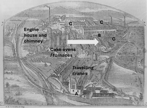
Figure 4. The details of the Iron Works
Later Ordnance Survey Maps of the Iron Works (from the 1880s) enable some functions to be identified – the travelling cranes in the foreground of the engravings, the coke ovens and furnaces, and the engine house and chimney. The report of the 1856 event found in the Worcester Chronicle that has already been mentioned contains some information that helps to understand what the engraving shows. The relevant paragraphs are as follows.
The Oxford, Worcester, and Wolverhampton railway running for a considerable distance along the side these works, drops down into their midst the green sand for the moulds, the Staffordshire ironstone, the unctuous red haematite from Cumberland, the limestone for the flux, and the Derbyshire cokes. The coal is raised from pits upon the premises, and in very few hours the raw material thus handed on the one side may be smelted, converted into pigs, cast into pipes, proved by the hydraulic press, smoothed, cut, and drilled, by machines of singular ingenuity and power, and shipped at the other side of the works upon the canal, to be borne from canal to river, from river to sea, and so to the Antipodes, to minister to the wants of rich and populous Australian cities, which in the memory of the present generation, had no name, or to complete the civilisation of communities planted few years since in spots where forests grew, and New Zealand cannibals roamed. What an illustration of human progress!
Several of Messrs. Cochrane’s relations and friends were distinguished by a white ribbon in their buttonhole, and escorted the various visitors through the works, showing them every process of iron manufacture and founding. The grinding of the sand for moulds, the curious processes of making, baking, and smoothing those moulds, the powerful steam engine for supplying cold blast to the two melting furnaces, the hydraulic lift raising the ” burden ” or supply of food to these huge retorts, whose fires never cease to devour day or night; the other engines for working the beautiful machinery of the fitting-room, where iron is planed, and drilled, and cut, with the same nicety, and almost the same facility, as if it had been deal, were all inspected in turn.
From this information we can conclude that raw materials, other than coal, were brought into the works from the line of the OWWR that ran along its boundary, presumably around point A on figure 4. Coal was mined somewhere on the site itself – perhaps we can see the pit head mechanisms at B in the figure? (By the late 19th century these mines had clearly become exhausted and further mines opened to the west of the Dudley to Stourbridge Road, with the coal brought into the works by a cable operated incline). Iron was then produced in the two furnaces, and then used in a variety of manufacturing processes in the various buildings marked C, before being loaded onto barges on the canal (and also presumably onto railway trucks on the OWRR siding). The process of manufacture thus moved from left to right across the engraving (north to south in reality) as shown by the arrow. In the above report we read that the products of the works were
borne from canal to river, from river to sea
which suggests that they were moved west along the Dudley and Stourbridge Canals, to the Staffs and Worcs. canal at Stourton and thus to the Severn at Stourport, and onward to Bristol and the sea. Such a movement would have avoided the notoriously congested Dudley tunnel. It also gives a degree of confirmation of the date as being around 1856, as in 1858 the Netherton tunnel opened, which would have made travel to the east to Birmngham and London much easier and would have presented an attractive route for the products of the Iron Works.


Thank you for this interesting article. Your reference to the 1856 Worcester Chronicle report prompted me to investigate the earlier history of Woodside further.
There appears to be a correction needed to the statement that Woodside was founded in 1840 by Alexander Brodie Cochrane and his son Charles. Charles was born in 1835 and would have been only about five years old. A partnership notice published in the London Gazette in 1842 names the partners as John Joseph Bramah, Alexander Brodie Cochrane the elder and Alexander Brodie Cochrane the younger. It records that Cochrane senior withdrew with effect from 31 December 1841, after which Bramah and Cochrane junior continued the business as Bramah and Cochrane, junior.
This is supported by A. B. Cochrane junior’s 1864 Institution of Civil Engineers memoir, which says that he first entered partnership with John Joseph Bramah at Bilston and that they subsequently founded Woodside in conjunction with Cochrane’s father.
All the best, Peter.
LikeLike
I have since found that A. T. C. and E. M. Lavender’s earlier Blackcountryman articles, Vol 16/2 and 17/2 for the Springs of 1983/4. The concern the Cochrane family and the Woodside Ironworks. They identify the founding son as Alexander Brodie Cochrane junior, describing Bramah as providing the capital for the Woodside furnaces and foundry.
All the best, Peter.
LikeLike