I have shown in an earlier post that the painter and architectural critic John Louis Petit (1802-1868) was a major landholder in the West Midlands in the nineteenth century. In this post I want to discuss in a little more detail what was perhaps the major estate that he owned – the Ettingshall Park estate in Sedgley, to the south of Wolverhampton.
The extent of the lands owned by Petit in Ettingshall in the 1840s are shown on the map below. The estate boundaries are taken from the Tithe Allocations and are superimposed upon the 1882 Ordnance Survey map of the area. The estate was in the north of Sedgley parish, just south of the Wolverhampton boundary and the holding was 413 acres in total. It is centred on Ettingshall Park farm and lies west of another large estate – that of Ettingshall Hall. Note that part of the northern boundary is shown as a dotted line, as it is hard to locate the precise boundary on the 1882 map because of variations in the topography due to mining.
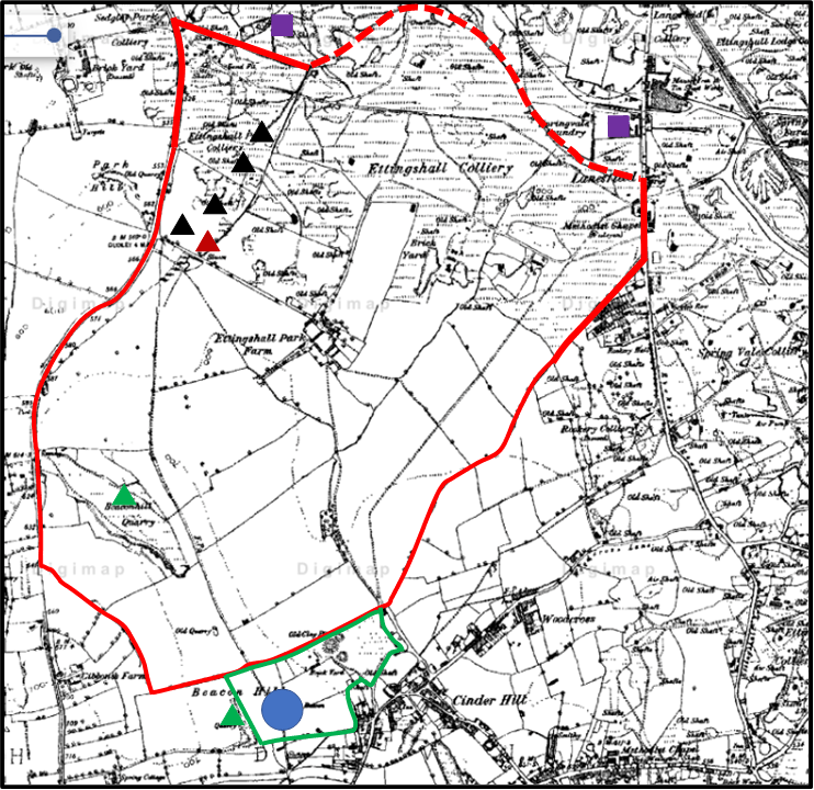
The Ettingshall Park estate. (The lands owned by John Louis Petit in the 1840s are outlined in red, and those owned by Louis Hayes Petit in green. Black triangles – collieries; red triangles – ironstone pits; green triangles – lime works; purple squares – iron works; blue circle – Sedgley Beacon
We first read of Ettingshall Park in 1581 when it was amongst the lands restored to Edward Sutton, 4th Baron Dudley, by Queen Elizabeth following the downfall of John Dudley, Earl of Northumberland who had taken over the estates through some morally dubious financial interactions with Edward’s father John Sutton, the third Baron. The fifth Baron, another Edward, sold the Estate to Charles Cornewallys of Norwich in 1597, and by 1604 it was either occupied or owned by one Thomas Marsh, styled as a gentleman. At sometime in the next century the Estate passed to the Hayes family. John Hayes appears to have been the Steward of the Dudley estate in the 1710s and 1720s and is referred to in various documents as being from Wolverhampton, and again styled as a gentleman. His son, another John, was in 1733 at the Junior Temple in London. John Hayes the elder died in 1736, and left Ettingshall to John the younger. This John himself died in 1745 and the estate went to his sisters. One of these sisters, Sarah was by then married to John Peter Petit, the second English generation of the Petits, and living at Little Aston. It then passed down the Petit family, as is described elsewhere. The Petits did not occupy it however, and it was leased to others – in the early years of the nineteenth century to Dudley Bagley, from 1808 around 1820 to Samuel Fereday, Ironmaster, and then to his son Dudley Fereday up to the late 1850s.
From at least the end of the seventeenth century, Ettinghsall Hall was occupied by the Homers, who exploited the estate for its coal reserves. By 1780, the mining works had encroached up the estate to such an extent that it was no longer fit to be a gentleman’s residence, so Richard Homer sold it and moved to Bromley House in Kingswinford, which they also exploited and eventually reduced to colliery waste. The Gibbons family of iron and coal masters were also near neighbours in the eighteenth century.
But now let us return to the map of the estate shown above. In the 1840s it formed a coherent block of land surrounding Ettingshall Park that was owned by John Louis Petit. A small block at the south of the estate was owned by his uncle and former MP, Louis Hayes Petit. Most of the land, even at that stage was arable or pasture. There were a small number of collieries to the north west, and two lime workings at Round Hill and Beacon Hill. However just beyond the estate heavy industry was beginning to encroach, with the Spring Vale Ironworks to the north east and the Parkfields iron works to the north. The former was served by basins from the Birmingham Canal (as indeed were most ironworks in the area). The underlying 1882 Ordnance Survey map shows a similar situation in the south of the estates, with most of the field boundaries being identical to those on the tithe map, but in the north mining activities have completely eliminated the fields (and indeed makes the estate boundary difficult to determine) and indeed many of the roads shown on the tithe map. In effect the area of mining in the 1880s came right to the edge of the South Staffordshire Coal Field.
Although John Louis owned the land, he leased it to others. The central area around Ettinghsall Park Farm was leased to Dudley Fereday as noted above, with smaller agricultural plots leased to Edwin Dixon, William Fletcher and Edward Jay. The mines and pits were operated by George Jones, John Neve and Coo, or the Parkfields Company who operated the nearby ironworks. Essentially we see here, as in so many places in the western Black Country at this time, the transition from a farming to an industrialised way of life.
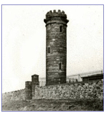
As noted above Louis Hayes Petit owned some land to the south of the Ettingshall estate. This encompassed the highest point in the locality at Beacon Hill. It was on this hill in 1846 that the Beacon Tower was erected, which still stands if in a somewhat dilapidated state. The Sedgley Local History society attributes the building of this tower to “a local landowner, Mt Petit”, although it might have been used for astronomical observations by Lord Wrottesley a well-known Staffordshire amateur astronomer. Whether this was John Louis or Louis Hayes is not clear, but perhaps we have here the architectural critic dabbling in architecture himself, if only in the construction of what can probably fairly be described as a folly.

One thought on “The Ettingshall Park Estate of John Louis Petit”