
Preamble
In canal histories, the Pensnett Canal is usually little more than a footnote – a short, one and a half mile private canal, often referred to by its owner’s name as Lord Ward’s canal, extending from the south end of Dudley tunnel with no locks or major engineering structures, to the Wallows to the south west, serving a number of iron works and mines on the way, from 1840 when it was built, through to the 1940s when commercial traffic ceased. What little there is to say about it is summarized in the definitive work of Hadfield (1), The Pensnett Railway by contrast, figures rather more prominently in railway histories, and indeed there are at least two books devoted to it (2), (3). Its origins can be traced back to the Kingswinford Railway of 1829, of Agenoria fame, with which it later merged, but it came into existence in its own right in 1843, again centred on the Wallows area, and eventually spread out across the southern Black Country, with more than 30 miles of railway, serving the mines and local industry in some form or other though to the 1960s.
In canal histories, one finds that the Pensnett Railway is rarely mentioned in any description of the Pensnett Canal, and similarly railway histories do not include the Pensnett Canal to any extent in the description of the Pensnett Railway. The history of both undertakings has thus been neatly compartmentalized. In this post, I will argue that this compartmentalization actually obscures something of importance – that both Canal and Railway have their origins in the same industrial and commercial needs and that the Pensnett Canal was conceived in part as a link in a much wider canal network that was never built to meet these needs. These needs were actually met in the construction of the Pensnett Railway, and indeed the initial construction was to a significant degree based on the abortive canal network proposals. Thus, the histories of the two undertakings need to be considered together, and in what follows we will attempt to do this in broadly chronological order.
The Kingswinford Railway

Figure 1 Canals and railways in the Kingswinford area in the 1820s (dark blue lines indicate canals, dark brown lines indicate railways)
In the early / mid 1820s, the area to the south of Dudley, mostly in the large parish of Kingswinford, was undergoing significant industrial development (figure 1). Coal and iron extraction was already underway in the south of the area around Brierley Hill and Brockmoor and a number of iron works were in operation. The transport needs of these industries were met by the three canals that existed in the area at the time – the Staffordshire and Worcestershire Canal to the west, which offered an outlet for industrial products to the northern cities (via the Trent and Mersey Canal) and to the south and west (via the Severn). The Stourbridge canal to the south which allowed coal and iron products to access the Staffordshire and Worcestershire at Stourton, and via the Dudley Canal and the Dudley and Lapal tunnels gave access to the central Black Country area and the route to London.
However, as the decade progressed, coal and ironstone mining and iron manufacture pushed northward – to the mines and iron works of Corbyn’s Hall, owned by the Gibbons brothers (4), and beyond that to what would be the vast iron works of Bradley and Co in Shut End owned by James Foster (5). The Earl of Dudley’s Estate, which was the major landowner in the area was also beginning to develop significant mining activities in the Barrow Hill and Old Park areas. These concerns needed a reliable means of transportation for their products around the country. Discussions were held with the Stourbridge company to consider a branch into the area, but these came to nothing. The Dudley Estate, then took the matter into its own hands and conducted what was to become known as the Kingswinford Railway, which connected the Corbyn’s Hall and Shut End areas with the Staffordshire and Worcestershire canal at Ashwood Basin (figure 1). Most of the land was owned by either the Dudley Estate or by James Foster with just a small area owned the other major landowner in the area, John Hodgetts Hodgetts-Foley of Prestwood, with whom a lease agreement was concluded. It consisted of a 1 in 28 incline of 500 yards in length from Ashwood Basin which was followed by a largely level stretch of two miles, before another (Foster’s) incline that led to the Corbyn’s Hall area. A branch incline led into the Bradley and Co ironworks. The inclines were horse drawn, but the central section was operated by the steam engine Agenoria, about which much has been written (6). The line thus met the immediate needs and provided an outlet for the produce from the area, and also provided a steady toll income for the Dudley Estate.
Canal developments
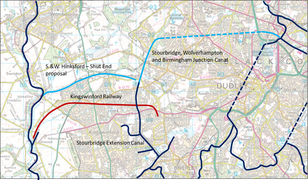
Figure 2 Canals and railways in the Kingswinford area in mid / late 1830s (dark blue lines indicate canals, that were constructed, light blue lines indicate canals that never passed beyond the proposal stage, dark brown lines indicate railways)
Whilst the Kingswinford Railway addressed some of the issues, others remained. Perhaps the most significant of these was to find an outlet for both coal and iron products to the north and east. In the short term this issue was solved in the mid-1830s by the construction of quite lengthy tramways to the Stourbridge Canal Feeder branch from the Corbyn’s Hall area and from the Dudley Estate mines in the Barrow Hill area and from there products could be carried back to the main line of the Stourbridge and Dudley canals and the Dudley tunnel (7). However, such transshipment was expensive and time consuming and some better form of carriage was required. Thus in 1836 a new company, formed by some of the Stourbridge Canal shareholders, put forward for parliamentary approval a proposal for a canal from the feeder branch at Brockmoor (at its summit level of 356 feet above sea level) to Corbyn’s Hall and Shut End, then onward to Straits Green and Sedgley with a flight of locks rising to the Wolverhampton level of 473 feet above sea level, and then through a one mile tunnel to the Birmingham Canal at Bloomfield (figure 2) (8). This canal – the Stourbridge, Wolverhampton and Birmingham Junction – would thus give access for the products of the Shut End and Cotbyn’s Hall area to both north and south without transshipment from tramways. It was opposed by both the Staffordshire and Worcestershire Company and the Dudley company as it potentially offered a bypass from the south that avoided the Wolverhampton locks on the Birmingham canal at the junction with the former, and also offered a more direct alternative to the Dudley Canal and tunnel. The former put forward their own proposal for a branch from Hinksford to Gornal Wood near Oak Farm, with 13 locks rising 104 feet, which was supported by the Dudley Estate (9*). The conjectured route (following the course of the Holbeche brook) is also shown in figure 2. The projected rise would have taken it to a height of around 320 feet, somewhat below the level of the Stourbridge, Wolverhampton and Birmingham Junction Canal. However, before parliamentary arguments could begin, it became clear that the Stourbridge Company could not raise the necessary finance, and the plan was curtailed and became a two-mile level canal from the Stourbridge to Shut End, with branches to Standhills and Bromley (the latter unauthorized) where it terminated. It was renamed the Stourbridge Extension Canal, and opened in 1840. As such it still served a useful purpose in allowing goods to be moved more speedily onto the Stourbridge Canal and then onwards, but it did not help with the issue of longer distance transport to the central Black Country and beyond.
Plots and intrigues
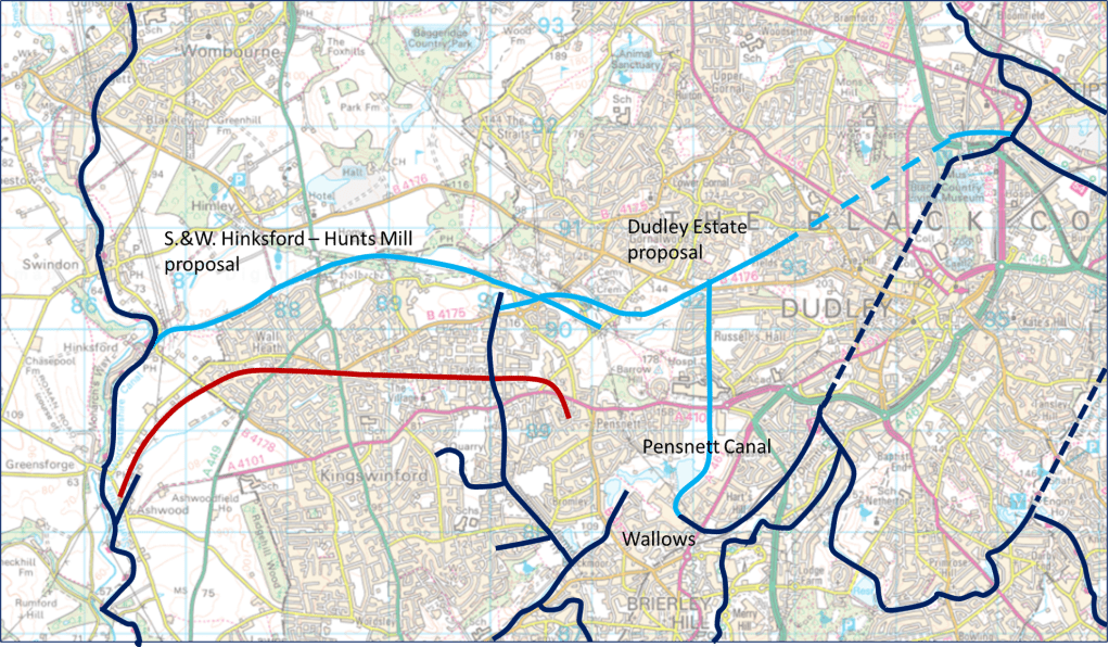
Figure 3 Canals and railways in the Kingswinford area in 1839/40 (dark blue lines indicate canals, that were constructed, light blue lines indicate canals that never passed beyond the proposal stage, dark brown lines indicate railways)
Whilst the Extension Cana was in its final stages of construction in 1839, two events occurred. The first was the building of the Pensnett Canal from the Wallows towards the southern portal of Dudley tunnel by the Dudley Estate. There were developing mining activities in the Wallows area, so of itself this was a justifiable step (figure 3). As it was on land owned by the Estate, no parliamentary approval was required. It was completed and in use by 1840. The canal was built on the Wolverhampton level of 473 feet. The start of its construction is captured on the Kingswinford Tithe Map of 1839 shown in figure 4 (10). The channel at what was to become the south west end of the canal can be seen, together with the “Pensnett Engine” that was used to dewater mines in the area – and which may have been intended to be the water supply to the canal.
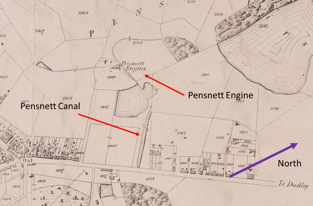
Figure 4. Extract from the Kingswinford Tithe Map of 1839 showing the early stage of construction of the Pensnett Canal and the Pensnett Engine at the Wallows. Note the direction of north.
Also in 1839, the Staffordshire and Worcestershire canal company revived their proposal of 1836 for a branch from Hinksford but extending somewhat further and ending near Hunts Mill (11*). This would have required more locks than the earlier proposal, to bring it to that point, which is around 350 feet above sea level – very close to the Stourbridge Extension Canal level. If it again followed the line of the Holbeche Brook, it would thus pass a little way to the north of the Extension Canal. The Stourbridge and Stourbridge Extension companies were alarmed by this, as they could see that potentially this branch could link with the Pensnett Canal in direct competition to their route. It would seem that meetings were held, and the proposals were withdrawn.
However, it was soon to be shown that the worries of the Stourbridge and Stourbridge Extension companies were quite justified. In 1840 a proposal was put forward by the Dudley Estate for a canal that joined with the Extension Canal at Shut End at the Stourbridge level of 353 feet, then rose through 19 locks to the Wolverhampton level on the Old Park area, where it was joined by an extended Pensnett Canal (12), (13). It then passed through a tunnel before joining the Birmingham Canal at Tipton near the northern portal of the Dudley Tunnel. This would have served the Dudley Estates mining developments in the Wallows and Old Park area and would also have served the Estate mines in the Barrow Hill area. Moreover, a direct connection with the proposed Staffordshire and Worcestershire branch would have been straightforward near the junction with the Stourbridge Extension Canal as they were on the same level. But, as Hadfield (1) remarks, the time was past, and the newer more efficient railways were already beginning to make inroads into the area, and the scheme was never progressed. Had it done so, the canal map of the south western black country would have been very difficult.
The Pensnett Railway
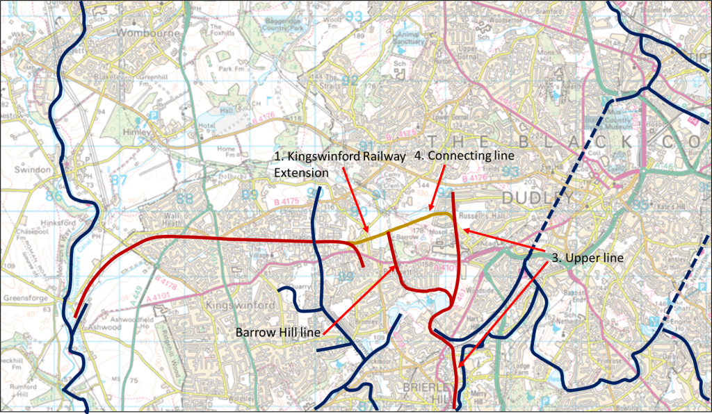
Figure 5. Pensnett Railway proposals of 1843 (dark blue lines indicate canals, dark brown lines indicate railways that were constructed, light brown line indicate railways that never passed beyond the proposal stage)
Although the Stourbridge Extension Canal and Pensnett Canal were completed and came into use, the need for rapid transport of the produce of the area to the Black Country, Birmingham and beyond remained. This was to become less pressing however, as local needs for coal and ironstone were increasing at the same time as the output from the traditional sources in the Brierley Hill area were decreasing. In particular the Level New Furnaces provided a ready market for the products of the Dudley Estate mines in the Barrow Hill area. This led to the Trustees of the Dudley Estate commissioning F. P. Mackelcan to develop schemes for railways in the area (2). He proposed the following lines (figure 5)
- An extension from the end of the Kingswinford Railway and running to the Dudley Estate mines at Barrow Hill and Old Park via a one in seventeen incline.
- A branch from this line that went up the one in twenty-five Barrow Hill incline, passed underneath the Dudley – Kingswinford turnpike road and skirted the Fens pool to join the third line below.
- The upper line from the mines of the Old Park area, underneath the Turnpike Road, around the Fens Poll to the Wallows, and then to the Level New Furnaces and the top of the nine locks.
- A line uniting the end of the upper line and the end of the extension.
It is striking how much these proposals were influenced by the earlier canal proposals. Firstly, the extension of the Kingswinford Railway would have served the same function as the canal branch from Hinksford proposed in 1836 and 1839, connecting the mines in the Barrow Hill area with the Staffordshire and Worcestershire canal. This proposal was not acted upon, as there were worries about the long-term stability of the existing Foster’s incline. Secondly the northern section of the upper line to Old Park (known as the “High lines”) follows closely the line of the extension to the Pensnett Canal proposed in 1840. Thirdly the line connecting the extension to the upper line, which again was not built, would have followed the route of the 1840 canal proposals. Finally it should be noted that the designs were very much based on canal technologies – level stretches of track connected by inclined planes, and there were canal transshipment wharves at the Wallows and at the end of the Delph branch. Whilst the Pensnett Railway was to develop very much further in the area in a more conventional railway manner over the coming decades, its genesis in the various canal schemes of the late 1830s and early 1840s seems to be clear. The Pensnett Canal and the Pensnett Railway developed because of the same industrial needs and are best considered as different solutions to the same transport issues. Their history is inextricably tied together.
References
1. Hadfield C “The Canals of the West Midlands”, David and Charles, 3rd Edition, 1985
2. Gale W. K. V. “A history of the Pensnett Railway”, Goose and Son, 1975
3. Williams N. “The Earl of Dudley’s Railway”, The History Press, 2014
4. Grace’s Guide, https://www.gracesguide.co.uk/Benjamin_Gibbons_(1783-1873)m Accessed September 2022
5 Grace’s Guide, https://www.gracesguide.co.uk/James_Foster, Accessed September 2022
6. Grace’s Guide, https://www.gracesguide.co.uk/Foster,_Rastrick_and_Co:_Agenoria , Accessed September 2022
7. Baker C J, “Kingswinford Manor and Parish”, https://profchrisbaker.com/kingswinford-manor-and-parish-new/ , Accessed September 2022
8. Dudley Archives “Plan of Stourbridge, Wolverhampton & Birmingham Junction Canal”, DE/6/12/3/26, 1836
9*. Staffordshire Records Office “Plan, book or reference and section of an intended navigable cut or canal called the Staffordshire and Worcestershire Canal at or near Hinksford in the Parish of Kingswinford, County of Stafford”, Q/RUm/86, 1836
10. Staffordshire Records Office “Kingswinford Tithe Map”, Staffordshire Past Track, 1839
11*. Staffordshire Records Office “Plan, book of reference and section of intended cut or canal called the Staffordshire and Worcestershire Canal Navigation at or near Hinksford, in the Parish of Kingswinford, County of Stafford, to a certain close of arable land called the Plain Piece near Hunts Mill”, Q/RUm/121, 1839
12. Dudley Archives, “Sections of Intended Canals between Tipton Green and Shut End and between Dudley and Coseley”, DE/6/12/3/37, 1840
13. Dudley Archives, “Plan of Railways, Canals and Roads between the Black Country and Birmingham”, DE/6/12/3/44, 1841
* At the time of writing (September 2022) I have not consulted these items in full, as Staffordshire Records Office is closed for refurbishment. I will do so as soon as I am able and make any necessary changes to this post. However, what I have written is consistent with the catalogue contents, and what is presented in (1).

Check out Whitworth’s 1775 map of the area canal system.
LikeLike
Not sure it is relevant to the blog – it predates the building of the Extension canal and the Pensnett by 6 or 7 decades, and only shows the Stourbridge
LikeLike
Hello
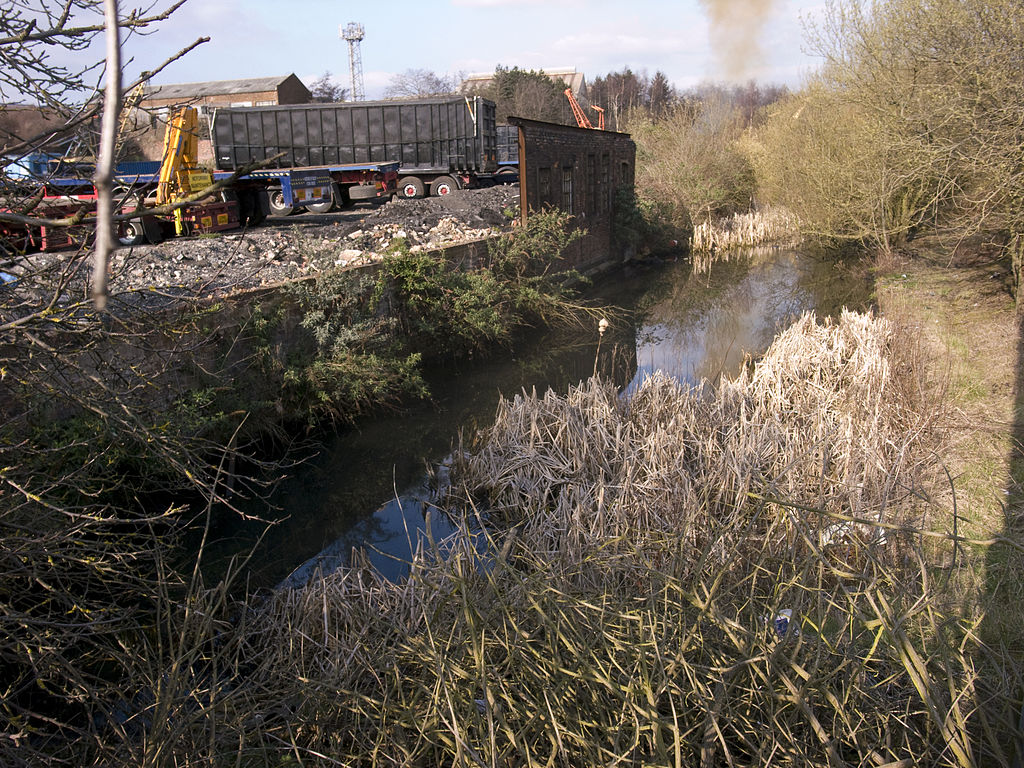
I recently walked the overgrown and rubbish strewn stretch of the railway from Bromley Bridge to Lenches Bridge.
What is its history please? Sorry if I missed it in the blog. The ‘platform’ near the Bromley end – is that the Pensnett or Bromley Halt please?
Clive Corbett
LikeLike
Thanks for this. The railway you walked along was the Kingswinford branch of the GWR built in the 1850s and later extended through Wombourne to Wolverhampton – see https://en.wikipedia.org/wiki/Wombourne_branch_line . From 1925 to 1932 there was a Stourbridge to Wolverhampton passenger service. The station near Bromley Bridge was Bromley Halt – https://www.railaroundbirmingham.co.uk/Stations/bromley.php . Pensnett Halt was an island platform just south of Lenches Bridge – https://www.railaroundbirmingham.co.uk/Stations/pensnett.php
LikeLike
Thanks so much for a swift reply
I used to cross from Crestwood to Pensnett on my way back from BHGS in the 70s
The locos were still running then
It is a pity it is abandoned and a dumping ground for shameful quantities of waste
LikeLike
“I used to cross from Crestwood to Pensnett on my way back from BHGS in the 70s”. As did I from 1965 to 1972!
LikeLike
Goodness me
Our paths must literally have crossed as I was there from 1968 to 1975
Clive
LikeLike