
First published on this site as a web age in June 2020, but republished as a blog post in august 2024 for consistency with other material.
Preamble
The Tribal Hidage, that most enigmatic of early texts, begins its perambulation of the polities in Southern England with a reference to “the first (or original) Mercian lands” (Davies and Vierck, 2010). It is the purpose of this short essay to unpack this phrase, and to see if it is possible to arrive at a coherent description of what was the original Mercia in the early / mid seventh century when, it will be seen, I take the Tribal Hidage to have been composed. We begin by briefly considering some aspects of the Tribal Hidage itself and then move on to a discussion of what can be deduced about early “kingdom” boundaries in the period of late antiquity – although the nature of the different polities discussed may well be very different from one another – through a consideration of detailed reconstructions from studies of regional history, and through consideration of ecclesiastical diocesan boundaries. We then discuss what might have been the nature of this early Mercian kingdom, through a consideration of the likely transport networks in its confines, and considers the historical events surrounding its establishment.
Throughout, we will work with what seems to be the developing consensus that it is difficult to separate Anglian, Saxon and British kingdoms on a strict ethnic basis, and most of the polities discussed will be of an ethnic mix, although it is clear that in the period of late antiquity following the withdrawal of the Roman armies, there was an increasing Germanic cultural influence throughout England, perhaps involving a relatively small migration from the Anglian and Saxon homelands. Such an approach seems to be consistent with recent archeological studies, which shows no major discontinuities in agricultural practices or evidence of major warfare in the early settlement period (Oosthuizen, 2017), and with recent genetic studies that show a homogeneous genetic background across most of England, although a genetic boundary between England Wales is apparent, and second level genetic differences can be observed in the South West, and in South Yorkshire (Lesley et al, 2015).
In what follows, an essentially geographical analysis will be presented in an attempt to locate the original Mercia, based on the drawing of boundaries of different types – kingdom boundaries, diocesan boundaries and county boundaries. Most of these are not contemporary with the period under consideration, and there is an implicit assumption that these boundaries reflect underlying and ancient boundaries from late antiquity. Whilst others have followed this route it is a somewhat dangerous course and open (quite rightly) to significant criticism. Also of course the concept of a boundary between peoples may or may not have been of relevance in the period under consideration and this needs to be borne in mind in what follows. These points having been made, we will in what follows use two scales of maps that both show, as the basis for relating to current geography, the pre-1974 county boundaries (see figure 1 for the larger scale of map that will be used). These counties were first defined in the 10thcentury, and remained relatively stable up to the 1974 re-organisation, although there have been continual minor modifications to boundaries over the centuries. In the area shown in figure 1, this has particularly affected the boundaries of Worcestershire, which became fragmented as a result of transfers of property from secular to ecclesiastical ownership and vice versa, with detached areas in the surrounding counties. These areas are not shown in figure 1 for clarity. There is one region however where the pre-1974 boundaries are not shown – the county boundary between the south west of Staffordshire and Shropshire – where there was an early (12thcentury) loss of land from Staffordshire to Shropshire due to the actions of Earl Roger to consolidate all his holdings into Shropshire (Thorn et al, 1986). As this region is particularly pertinent to the discussion that will follow, the Domesday boundaries for this region will be shown in all the maps that follow.
Figure 2 uses this map to illustrate the river systems in the English Midlands – and in particular the Trent, Severn, Wash and Cheshire basins. It is clear that the county boundaries in general follow river basin boundaries. In the area of interest here, this is particularly the case for the Staffordshire / Cheshire, Shropshire / Cheshire and Staffordshire/ Shropshire boundaries. The southern Severn / Trent basin boundary is also coincident with county boundaries, except in the case of Warwickshire which sits across the watershed between them.
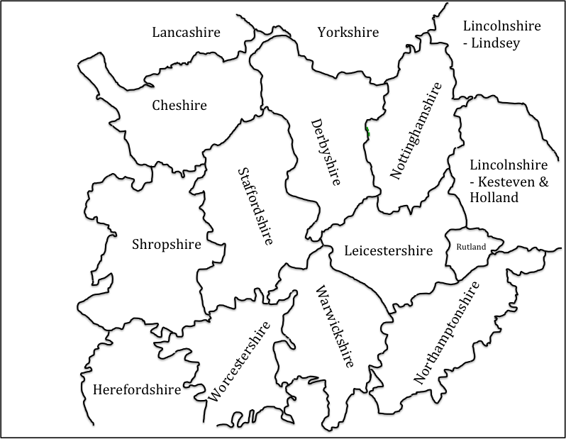
Figure 1. The base map, showing pre-1974 county boundaries and names
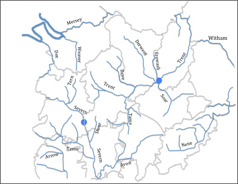
Figure 2 Rivers and county boundaries
(Only major rivers and tributaries are shown. The blue filled circles indicate riverine locations of importance to the argument that follows below.)
The Tribal Hidage
The Tribal Hidage exists today in a number of different manuscripts, which are set out and compared by Dumville (1989). It essentially consists of two lists of kingdoms / polities of various sizes, with hidages attached to each entity. The date of the original document is disputed, with dates from the 620s to the 780s suggested (Corbett, 1900; Hart, 971; Higham 1995). I find the approach taken by Higham (1995), who proposes date in the 620s, the most persuasive, although this does not appear to be the universal view of historians. He suggests that it is in origin a tribute list of Edwin of Deira, dating from 624/5. The primary list is effectively a list of tributes payable to him from what Higham terms the Midlands “Overkingship”, whilst the secondary list was added perhaps a year later to indicate the tribute from the Southern “Overkingship”. The level of hidage seems to be standardized to 7000 for county sized entities, and to multiples of 300 for smaller entities particularly in the region know as Middle Anglia around the Wash and the East Midlands. For the Southern Overkingship entries in the secondary list, there is clearly a punitive element, particularly with the 100,000 hides allocated to Wessex.
For the current purposes it is the order of the entries that is of most interest. The kingdoms on which most authors can agree are shown in figure 3 for both the primary (P) and secondary (S) lists. Original Mercia (P1 on the figure) is placed at the historic centre of the kingdom in south Staffordshire around Lichfield and Tamworth. A number of points arise from this figure.
- There is a well-described clockwise progression in the primary list (and a subsidiary clockwise progression in the Fenland entities – based on the recent wok of Osthuizen (2017) and similarly in the secondary list. The latter list is indeed almost a closed loop. This is so marked, it seems to have been a specific intention on the part of the original compiler of the list.
- The list includes Elmet, which was incorporated into the Deiran kingdom by Edwin (i.e. before 633) and Lindsey and Hatfield, which were never associated as a dual entity after the reign of Edwin. This argues for an early date for the Hidage (Higham, 1995).
- The list does not include the Magonsaete in the south Shropshire / Herefordshire region, which was certainly in existence by 680 when it was ruled by Merewalh (note the British name), who is described by some as a son of Penda of Mercia. Again this argues for an early date (Pretty, 1989).
- The area of Leicestershire and Northamptonshire, which the diocesan boundaries suggest is in Middle Anglia (see below) are not allocated any of the agreed kingdoms on the Tribal Hidage map. This suggests to me that the Noxgaga (P18) and Ohtgaga (P19) at the end of the primary list, both county sized entities, should be located in this area, rather than in the Middlesex / Surrey area suggested by some authors (Hart, 1977). This identification would make the primary list an almost closed loop.
- This identification identifies the area around which the primary list loops to be in the Nottinghamshire area. This will be seen to be of relevance in what follows.
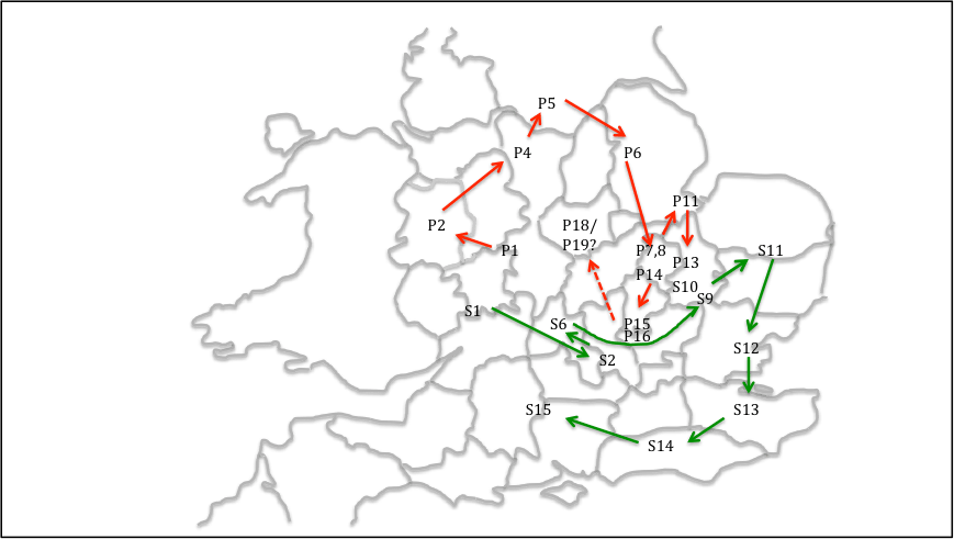
Figure 3. Tribal Hidage. “Firm” locations of regions in the primary and secondary lists
(P1- Myrcna lands; P2 – Wocensætna; P4- Pecsætna: P5 – Elmedsætna: P6 – Lindesfarona mid Hæþfeldlande: P7 – Suþgyrwa: P8 – Norþgyrwa: P11 – Spalda; P13 – Herefinna : P14 – Sweordora P15 – Gifla : P16- Hicca: P18- Noxgaga: P19 – Ohtgaga; S1 – Hwinca; S2 – Cilternsætna; S6 – Færpinga; S9 – Eastwilla; S10 – Westwilla; S11 – Eastengle; S12 – Eastsexena; S13 – Cantwarena; S14 – Suþsexena; S15 – Westsexena)
Kingdom and Diocesan boundaries
The work of local historians in various parts of England, who have carried out detailed work on boundaries of sub-Roman, early Anglo-Saxon polities that enables the boundaries of these polities to be drawn in more detail than the Tribal Hidage allows, even though these are to some extent speculative. Here we consider the work of Higham for the Pecsaetna in the Peak (Higham, 1993), Breeze for Elmet in South Yorkshire (Breeze, 2002), Parker for Hatfield in South Yorkshire / North Nottinghamshire (Parker, 1992) and Bassett for the kingdom of Lindsay (Bassett, 1989), All of these authors would, I am sure, have significant caveats for their work, but taken together they form a useful set of data. The boundaries they identify are again shown on figure 4. Higham suggests that the area of the Pecsaete consist of the Cheshire Domesday hundred of Hamestan, the Derbyshire hundred of the same name, plus the Staffordshire hundred of Totmonslow. The area of Hadfield identified by Parker includes not only the area of south Yorkshire that is usually so identified, but also north Nottinghamshire. The boundaries of the Pecsaete and Hatfield are, on this basis separated by a thin strip of Derbyshire (essentially Scarsdale Hundred), and it seems likely that the territory of one or the other of them extended to fill the gap between them. We choose here to extend the region of the Pecsaete into this area, as it will be seen below that a significant diocesan boundary separates Derbyshire from Nottinghamshire. Elsewhere the region of Elmet identified by Breeze can be seen to border on the Pecsaete, and the area of Lindsey is, following Bassett, taken to include not only the pre-1974 Parts of Lindsey to the north of the River Witham, but also a similar sized area to the south.
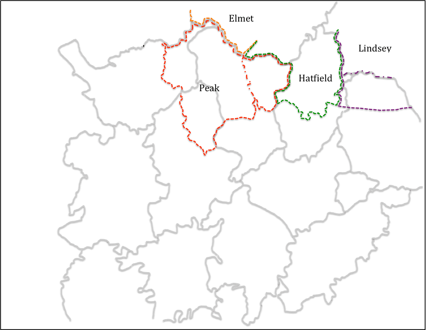
Figure 4 Kingdom boundaries in the north Midlands
(red dotted line shows the region of the Pecsaetna assumed in what follows – the red chain dotted line ins the boundary identified by Higham; the green dotted line shows the region of Hatfield; the brown dotted line shows the region of Elmet; the purple dotted line shows the region of Lindsey – with the chain dotted line showing the southern boundary of the Parts of Lindsey)
Now let us move to the consideration of the boundaries of church dioceses, particularly in the English Midlands. Some historians have expressed doubt about how the known medieval boundaries can be extrapolated back to the seventh century, the period under consideration here. This is particularly true of those areas which fell within the Danelaw where a number of dioceses ceased to operate. Nonetheless, they are used here for two reasons – firstly the 10th century Midland county boundaries follow these diocesan boundaries in many places and this suggests that the latter predated the former, and secondly, in many parts of the Midlands, there seems to be no record of any historical events that could have led to boundary changes. This is indeed the approach followed by Hart (1977) in his consideration of the Tribal Hidage, although he did not follow this approach to its logical conclusion.
The Mercian diocese came into existence in 655, and in its early days it covered a large region across the English Midlands. The situation changed with the reorganization of Theodore of Tarsus (Archbishop of Canterbury 669-690), who created dioceses based on “kingdoms” – a Lichfield diocese reduced in size for Mercia, Hereford Diocese for the Magonsaete (676), Lincoln diocese for the kingdom of Lindsey (678), Worcester diocese for the Hwicce (680) and Leicester diocese for the Middle Angles (681) (Podmore, 2008). These dioceses, as they existed in the late Anglo-Saxon era, are shown in figure 5, together with the relevant county boundaries (Ordnance Survey, ??).
From this figure it can be seen that the Mercian diocese covers much of west Warwickshire, Staffordshire, part of Shropshire, Derbyshire and the “land between the Mersey and the Ribble”. Clearly as such it encompasses the areas listed in the Tribal Hidage as Wocensætna and Pecsaetna, as well as whatever polities existed north of the Mersey, which must thus have been incorporated into Mercia sometime between the compilation of the Tribal Hidage (in 625 if Higham’s argument is accepted) and the re-organisation of dioceses in the 670s.
Equally significant are those areas that are not part of the Mercian diocese. Firstly Nottinghamshire has been, from at least 956 when the church was re-established following the Danish conquests, part of the York diocese (Stenton, 1968). At this time the area based on the minster church of Southwell, which was granted to Oskytel, Archbishop of York by King Eadwig. It seems likely to methat this was simply are-establishment of the pre-conquest status quo. There is a local tradition that the area was first evangelised in the early seventh century by Paulinus operating from York. Thus, in ecclesiastical terms, Nottinghamshire looks to the north and the Humber, rather than to the Midlands and the diocese of Lichfield. Secondly, the counties of Leicester and Northamptonshire are in the Leicester (i.e. Middle Anglian) diocese. Hart, in his definition of the geography of Mercia, arbitrary labels this area as “outer Mercia” (Hart, 1977), an entity which has no historical context at all. The fact that it is regarded as being in Middle Anglia is consistent with the argument set out above that the Noxgaga and Ohtgaga should be located in this area.

Figure 5 Diocesan and county boundaries.
Locating the original Mercia
An attempt can now be made at locating the original lands of Mercia, about which the Tribal Hidage seems to revolve – see figure 6. The diocesan boundaries and boundaries of other kingdoms would suggest that this region included west Warwickshire, south Staffordshire and south and east Derbyshire. The main unknowns are the location of the northern and western boundaries. With regard to the northern boundary, this has been chosen to exclude the long neck of land between the regions of the Pecsaete and Hatfield, as identified by Higham and Parker, as this seems the more logical geographical boundary. The boundary shown in figure 6 thus forms the southern boundary of the Domesday Scarsdale Hundred. With regard to the western boundary, the logical place for this would be on the watershed between the Trent and Severn basins. This is followed by the western border of Staffordshire, except for Seisdon hundred in the south, where part of the catchment of the Stour, a tributary of the Severn, is included within Staffordshire and the Domesday county boundary was the River Severn itself. The boundary of the original Mercia is drawn to follow the Staffordshire boundary even in this region for reasons that will become apparent below. The original Mercia thus consists of the Staffordshire Domesday hundreds of Seisdon, Cuttlestone, Pirehill and Offlow (the latter containing Lichfield), the Derbyshire hundreds of Walecross, Appletree, Litchurch and Morleystone and the Warickshire hundreds of Coleshill, Bumblelow, Stoneleigh, Marton and Hunesberi. Many authors have pointed out that this region lacks natural boundaries or defensive positions of any sort, and this will be considered below. But at this point the reason for the name of the kingdom – the borderlands – becomes obvious if this area is considered in terms of the Roman Civitas, the broad areas of which are also shown on figure 7 (it is not being possible to draw these with any precision) together with an indication of the Provincial areas following the reorganization of Diocletian (Jones and Mattingley. 1993). There is coming to be agreement that throughout the fifth and sixth centuries there was some continuity in Civitas level government, at least in the west of England, either through Governors or through kings (Dark, 2000). On the presumption that something similar to these Civitas continued to exist in some form into the late 6thcentury, it can be seen that the original Mercia sat across the borders of a number of them – the Dobunni in Worcestershire and Gloucestershire, who seem to have morphed into the Hwicce; the Cornovii in Shropshire / Chester, who became the Wocensætna, the Corieltauvi in Warwickshire / Leicestershire / Lincolnshire; the Catuvellauni in Northamptonshire / Bedforshire / Buckinghamshire, and, if it actually existed, Lutadorum in the Peak District, who can perhaps be identified with the territory of the Pecsaete. It would seem that Mercia took land from all of these and straddled the borders of each, and in doing so straddled the borders of at least three of the four late Roman provinces.
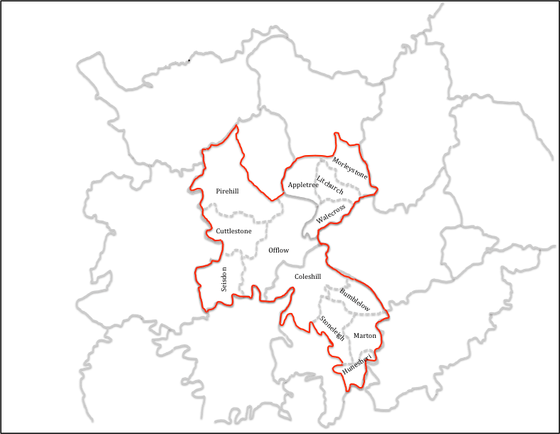
Figure 6. The original Mercia mapped.
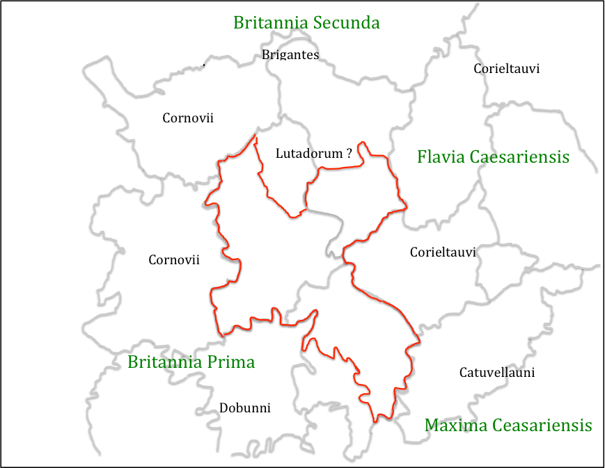
Figure 7. The original Mercia and Civitas and Provincial regions
(Civitas names in black, Provincial names in green)
The point has often been made that the original Mercia, whatever its precise location, lacked natural boundaries. However this is probably a misconception. Figure 8 shows the original Mercia as identified above, together with the established Roman road network, which was usable well into Medieval times, and also some conjectural, but likely roman roads. This changes the picture of Mercia significantly. It can be seen that the centre of the kingdom at Lichfield / Wall sits on a major junction of roads, from where small bands suitably mounted and armed could reach all parts of the kingdom very quickly and could establish control over a wide area. Also at the borders there were at least the locations of Roman towns which could have acted as regional centres – Water Eaton to the west, Greensforge to the south west, Metchley to the south, High Cross to the south east and Derby to the north. Perhaps most importantly this network would also allow control of trade across the whole region – and thus control of major trading routes across England – Watling Street between High Cross and Water Eaton; Ryknield Streets between Derby and Metchley, as well as the northern saltways from Droitwich. To this road network, can be added strategic riverine locations at Sawley – the junction of the Trent, Erewash and Soar, and on the Severn at Quatford, which could thus control major river traffic flows. The latter is the major reason for suggesting that Seisdon hundred in Staffordshire was part of the orginal Mercia, as it gave control over the saltway at Greensforge and the roads to the borders and mid Wales, as well as access to the Severn at Quatford. This interpretation thus sees the original Mercia as very much a commercial enterprise as well as one in kingdom building.

Figure 8 – Communications networks
(blue indicates probably and possible Roman Roads; red indicates locations within the Original Mercia; green indicates major locations outside this area. Blue circles indicates the riverine crossings at Quatford (in the west) and Sawley (in the east)
Finally the question arises as to whether or not there is a historical context into which the above scenario could fit. Here there is little alternative but to use the evidence of the various chronicles and early histories, and which are open to serious challenges as to their veracity and utility. With that proviso, they are used and viewed as broadly reliable in what follows.
The third quartile of the sixth century was a time of expansion by the kingdom of Wessex, as illustrated in figure 9. In 568 a Wessex force led by Ceawlin and Cutha, defeated Aethelberht of Kent, and pushed him back towards his homeland. In 571, in a northern advance, Cuthwulf defeated British force at Bedcanford (usually taken as Bedford) taking control of a number of towns in that region. This was followed in 577 by the battle of Deorham, where three British kings were again defeated by Cuthwine and Ceawlin and three major towns taken – Bath, Glouccester and the capital of the Province of Britannia Prima, Circencester. Then for 584, for Anglo-Saxon chronicle reads
Ceawlin and Cutha fought with Britains at the place called Fethanleag and Cutha was killed, and Ceawlin took many townships and countless spoil and returned in anger to his own.
Here Cutha is a king in Wessex, and Fethanleag has been identified as Stoke Lyne near Bicester in north Oxfordshire – a few miles south of the southern border of Mercia shown in figure 6. Davies (1977) relates this to an entry for the next year in the Henry of Huntingdon’s Historia Anglorum which states
585 Beginning of the kingdom of Mercia, with Crida
If one can make that equation, this suggest that Cutha met his match in an essentially British force that stopped the northern expansion of Wessex, and that this force was led by Crida who then went on to establish the kingdom of Mercia as outlined above, and a dynasty in the form of Crida, Pybba and Penda. Note the partially British name of the latter, which strongly suggests a kingdom of mixed ethnicity. The dynasty was known as the Iclingas after the (perhaps mythical) ancestor Icel, and the Anglo Saxon Chronicle gives the names of his descendants before Crida as Cynewald and Cnebba. As noted by Myers there are a number of place names that reflect the name Icel across Suffolk, Cambridgeshire and Hertfordshire, and there is a concentration of names based on Pybba (Pedmore) and Penda (Pendford, Pinvin) in the Worcestershire / south Staffordshire area, suggesting the popularity of these names around there.
The nature of the original Mercia is however still elusive. It may be that Crida’s family of the 580s, simply took the region centred on Wall and held it by force of arms against the neighbouring polities. Dark would suggest that these polities were the remains of the sub-Roman Civitas system, which to the east were clearly (from the evidence of the small polities of the Tribal Hidage in the East Midlands) in the process of dissolution due to internal pressures, and perhaps also the pressure of migrating Saxons from the area around the Wash and the Humber; whilst in the west bureaucratic Civitas governments of the Dobunni and Cornovvii may well have been in their final sharp decline. This suggest the possibility (and it can be rated no higher than that) that the family and their followers were effectively foederatiemployed by these bureaucratic governments to resist the growing pressure of Wessex from the south and the chaos enveloping their eastern borders. If so, then their eventual subjugation by an expanding Mercia might suggest that this was ultimately not a good move.
In the early seventh century, there does seem to have been a break in the succession, and Bede tells us of another Mercian king – Cearl – who took the refugee and later Deiran King, Edwin, under his protection in around 605. Higham argues that he was the Midlands Overking at the time, able to resists the demands of Aethelfrith in Northumbria for the return of Edwin (Higham, 1995). The fact that Edwin was able to reach Cearl easily, and after Cearl’s death find refuge with Raedwald in East Anglia, strongly suggests that Ceorl’s activity was in the north midlands – perhaps in the south of Nottinghamshire which has been identified as an anomaly in diocesan terms. In this scenario, Cearl would have been of northern Anglian stock, but Bede would have referred to him as king of Mercia, because the region in which his power was centred was Mercian in Bede’s day. Taking this further one can perhaps see the primary list of the Tribal Hidage as a tribute list of Cearl, in which the punative 30,000 hides of the original Mercia reflected a recent takeover from the Icinglas dynasty that was not to prove permanent. It can also be speculated that Ceorl’s territory was that of the North Mercians mentioned by Bede, with the original Mercia being South Mercia. In taking over Ceorl’s territory, Penda would thus become the first king to “separate the Mercians from the Northumbrians” as also noted by Bede. But here we are in the realms of speculation, and his must be only one of many possibilities of the situation on the ground in the early seventh century.
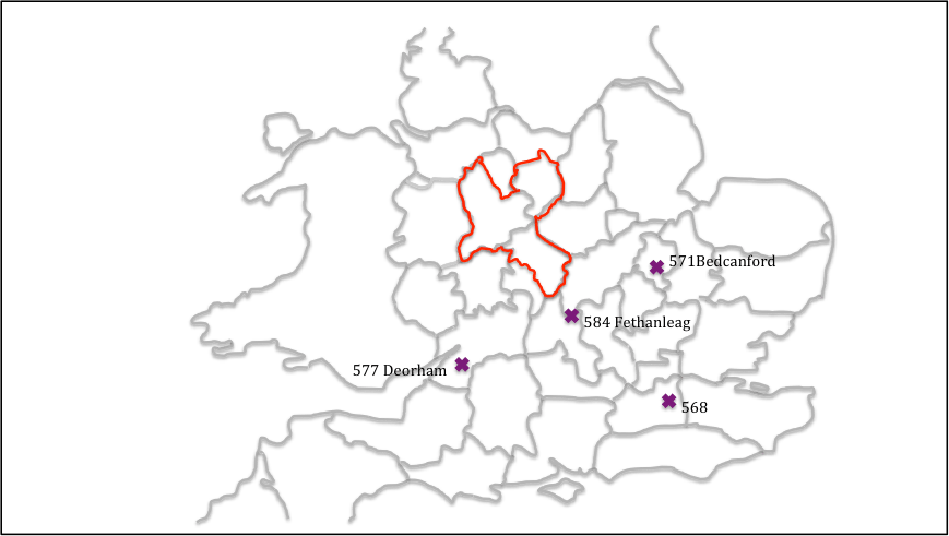
Figure 9 Anglo Saxon Chronicle battles of the mid / late sixth century
References
Bassett S (1989) “Lincoln and the Anglo-Saxon see of Lindsey”, Anglo-Saxon England, 18, 1-32
Breeze A (2002) “The Kingdom and Name of Elmet”, Northern History, 39, 2, 157-171
Brownbill J (1925) “The Tribal Hidage”, The English Historical Review, 40, 160, 497-503, Oxford University Press
Corbett W (1900) “The Tribal Hidage”, Transactions of the Royal Historical Society, New Series, 14, 187-230
Dark K (2000) “Britain and the End of the Roman Empire”, Tempus
Davies W (1977) “Annals and the origin of Mercia” in “Mercian Studies” edited by Ann Dornier, Leicester University Press
Davies W, Vierck H (2010) “The Contexts of Tribal Hidage; social aggregates and settlement patterns”, Frühmittelalterliche Studien
Dumville D (1989) “The Tribal Hidage: an introduction to its texts and their history”, in: Bassett, S (ed.), The origins of Anglo-Saxon kingdoms, Studies in the Early History of Britain, Leicester: Leicester University Press, 225–230, 286–287.
Hart C (1971) “The Tribal Hidage”, Transactions of the Royal Historical Society, Fifth Series, 21 (1971), 133-157
Hart C (1977) “The kingdom of Mercia” in Mercian Studies, edited by Ann Dornier, Leicester University Press, 43-62
Higham N (1993) “The origins of Cheshire”, Manchester University Press
Higham N (1995) “An English Empire – Bede and the early Anglo Saxon kings”, Manchester University Press.
Jones B, Mattingly D (1993) “An Atlas of Roman Britain”, Blackwell
Ordnace Survey (???) “Monastic Britain”, South sheet, 2nd edition
Oosthuizen S (2017) “The Anglo-Saxon Fenland”, Windgather Press
Leslie S and 18 other authors (2015) “The fine-scale genetic structure of the British population”, Nature 519, 309-314
Parker M (1992) “The Province of Hatfield”, Northern History, 28, 1, 42-69,
Podmore C (2008) “Dioceses and Episcopal Sees in England – A Background Report for the Dioceses Commission”, DC/R3
Pretty K (1989) “Defining the Magonsate” in: Bassett, Steven (ed.), The origins of Anglo-Saxon kingdoms, Studies in the Early History of Britain, Leicester University Press, 171-183
Stenton F (1968) “Anglo Saxon England”, The Oxford History of England, 2nd edition, Oxford University Press.
Thorn F, Thorn C (editors), Parker C (translator) (1986) “Domesday Book – Shrops
