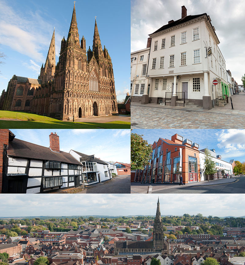
A compilation of some of my blog posts from the past few years about St Michael’s church in Lichfield.
Saddlebacks and serendipity. A brief post that identifies the occupant of the notable Saddleback grave in St. Michael’s churchyard (3rd January 2025)
The changing face of death. A blog post introducing a statistical analysis of the interment records and monuments of St Michael’s churchyard in Lichfield from 1813 to 2012, looking at the changes in funerary patterns over that period. (February 24th 2023)
The St. Michael Chalice of 1684. A very brief blog post with a photograph of a 1684 communion chalice from St Michael’s Lichfield, sold in the 1850s to pay for something more modern. (December 30th 2020)
Some summer reading – a compilation of a few of my blog posts about the history of Lichfield.
Lichfield – a pre-conversion pagan cultic centre? A post that considers the early history of the city of Lichfield, and argues that it might have been a place of cultic significance before the Christian era. Some of this is very speculative, but may be of interest
“That way madness lies” – the search for solar alignments in Lichfield The city of Lichfield lies on a rough midwinter solar alignment with the Bronze Age site at Catholme. This post investigates this further to see if this alignment is intentional or merely accidental. (April 12th 2020)
Lichfield’s First Station Master. A post that looks at the career of Lichfield’s first Station Master and church warden of St. Michael’s, William Durrad. (January 15th 2021)
Material in the following paragraphs is repeated from an earlier post as an introduction to Stephen Glynne and his church notes.
The Glynne Baronetcy dates back to 1661, with its main estate at Hawarden in Flintshire. The 8th Baronet, Sir Stephen Glynne (1780 to 1815) married Mary Griffin, daughter of Lord Braybrooke. After his early death, he was succeeded by his son Sir Stephen Richard Glynne, the 9th Baronet (1807-1874). I first came across him as the owner of the Oak Farm Iron Works in the Black Country, which was the subject of a spectacular financial crash. Glyne was saved from financial ruin by the efforts of his brother-in-law, the future Prime Minister William Gladstone, at very considerable expense to the latter.
More widely, Stephen Glynne is best known as a church antiquarian. Over the course of his adult lifetime he visited over 5000 churches in England and Wales, making notes, and in some cases sketches of their architecture, plans and furnishings. These notes can be found in 106 volumes now housed in the Gladstone Library at Hawarden. Only a small minority of these have been transcribed and published. Here we give a transcript of his notes for St. Michael’s in Lichfield. The history of the church is set out in detail in my four part ebook. The restoration of the early 1840s, which is of relevance to what follows, is described in Part 3. At that time the Lichfield Society for the Encouragement of Ecclesiastical Architecture were instrumental in the rebuilding of the church (and the chancel in particular) in the prevailing gothic fashion.
Stephen Glynne’s description of St. Michael’s, Lichfield
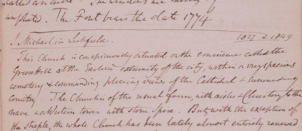
Stephen Glynne’s notes on St. Michael’s church in Lichfield are brief and mainly straightforward. They are oddly dated 1827 and 1849, but the description is clearly from a visit in 1849 after the extensive “restorations” of the early 1840s. There are a couple of entries on a blank facing page however that refer to the pre-restoration church and that might refer to an 1827 visit (given at the end of the transcript below).
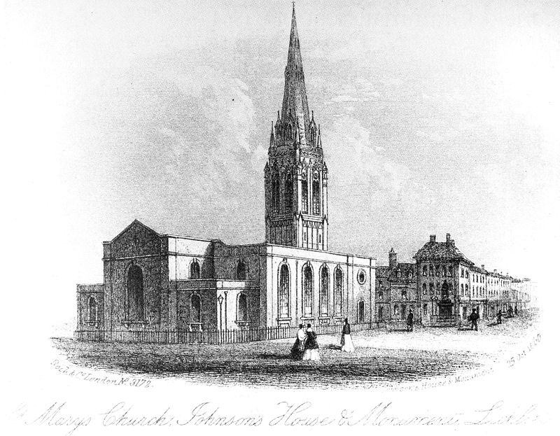
The church is conspicuously situated on the eminence called the Greenhill at the eastern extremity of the city within a very spacious cemetery commanding pleasing views of the Cathedral and surrounding county. The church is of the usual form with aisles and clerestory to the nave and a western tower with stone spire. But with the exception of the steeple, the whole church has been lately almost entirely renewed and in great measure rebuilt in tolerably good style. The steeple which is of red sandstone, appears to be a three ?? (1) of plain kind. The tower is embattled with corner buttresses, a string course under the belfry only. The belfry windows of two lights on the north and south is a long ??? slot -a questionable lancet on the west, but no west door. The spire is octagonal but not ribbed, having three horizontal bands and two tiers of spire lights, which are on the same sides. The north aisle, as rebuilt, has a low pitched roof and a battlement with three Perpendicular windows. The south aisle is wider and loftier with a high pitched roof and Perpendicular windows, varying in tracery. At the east end has been added a gabled chamber for receiving the Organ (2). The nave is of four bays, the arcades with pointed arches and octagon columns. The chancel has been wholly rebuilt in the Perpendicular style – its east window a triplet and on each side three single lancets. The chancel is groined, the ribs springing from shafts (3).The clerestory of the nave has a high pitched tiled roof and windows of two lights. The north porch is set in the western bay .
(4) The ancient chancel had a three ?? (1) east window, and the former chancel, as appears from a view in Shaw’s Staffordshire, had a quasi clerestory, an upper tier of windows. The whole of the former church was perpendicular.
Notes
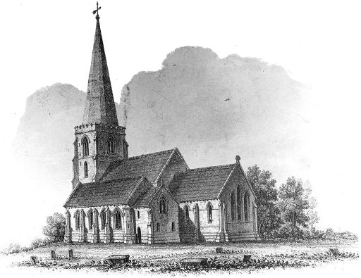
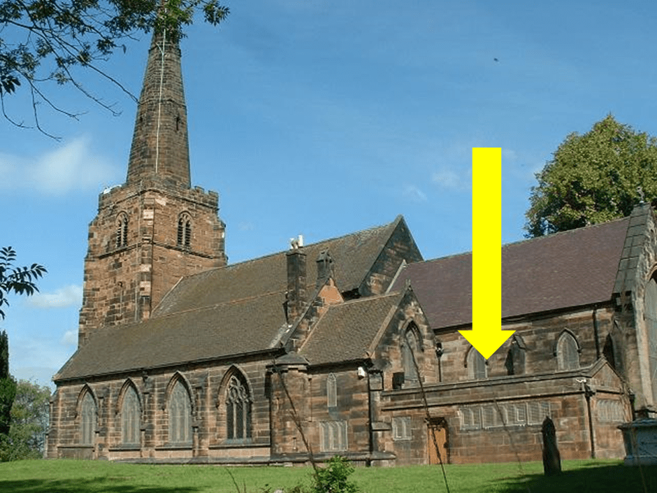
1. This symbol can’t be read, but it is the same at both places where it occurs. 2. The description of the church matches what can be seen today, with one exception – the description of a gabled chamber for the organ. This clearly refers to a structure that was replaced by the current choir vestry in 1923 ad can be seen inthe foreground of the picture above. 3. The restored chancel was itself significantly altered in the late nineteenth century, with much of the work of the 1840 restorers removed or altered. 4. The text in this paragraph probably refers to an 1827 visit.
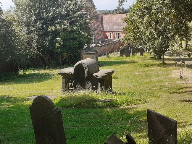
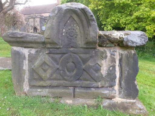
In 2021 I discussed some of the early graves in St. Michael’s churchyard in Lichfield. Amongst these was the distinctive “saddleback grave” shown in Figure 1 below, one of the five listed monuments in the churchyard. At the time I wrote as follows.
The inscription is very worn and the dedication of the monument can’t be read. This grave features in a nineteenth century drawing that is in the William Salt library ……. That drawing gives the date of the grave as 1674, and with a little imagination this can be made out on the tomb itself. Apart from the date, it is the style of the grave that makes it so distinctive. It is a shame that the dedication is illegible.
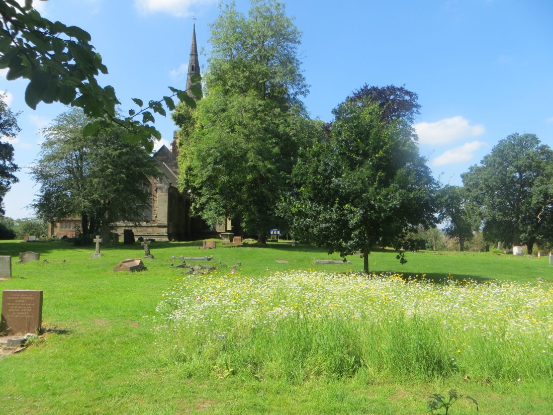
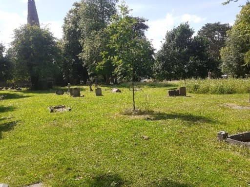
Figure 1 The Saddleback grave in 2021
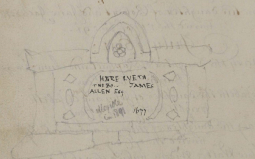
And this is where serendipity comes in. Over the last few days I have begun to think about filling in some of the gaps in my long term project to collate the memorial inscriptions of St. Michael’s churchyard with the burial registers – specifically to include material from the early registers up to 1812. A very helpful archivist at Staffordshire Archives told me that these have been scanned and can be found on Find my past. So I have been busy doing some mass downloads of the material during my seven day free trial (as you do). Whilst doing this I came across the sketch shown in Figure 2 in the register from 1680-1741, on a blank page opposite the entries from November to March 1691 (note this was before the calendar change!)
Figure 2. The sketch from the 1680 to 1741 Register
It clearly shows the Saddleback grave and gives the inscription as
Here lyeth the bo… of James Allen Esq…..1677
There is another note in lighter script that says
Illegible in 1891
So it seems we have an identification of the occupant of the Saddleback grave – although the date is given as three years later than indicated on the William Salt picture. Checking back on the records however in the 1574 to 1680 register, the only entry that corresponds to the name is from 1674
April 13th Mr James Allen, Magistrate, Beacon St
Beacon St is somewhat conjectural however – it is not easy to read. So it looks as if the William Salt date is the correct one.
The registers tell us little else. There is an entry for the marriage of James Allen (Gent) to Mrs. Hester, daughter of Richard Pyot (Dyot?) in November 1658 at St. Mary’s which seems possible. However this was in the Civil War / Commonwealth period when records become very patchy, so there may have been other about with the same name. If any reader knows more of James Allen, then please let me know. But a least we now have a name.
First published on this site as a web age in June 2020, but republished as a blog post in august 2024 for consistency with other material.
Preamble
The Tribal Hidage, that most enigmatic of early texts, begins its perambulation of the polities in Southern England with a reference to “the first (or original) Mercian lands” (Davies and Vierck, 2010). It is the purpose of this short essay to unpack this phrase, and to see if it is possible to arrive at a coherent description of what was the original Mercia in the early / mid seventh century when, it will be seen, I take the Tribal Hidage to have been composed. We begin by briefly considering some aspects of the Tribal Hidage itself and then move on to a discussion of what can be deduced about early “kingdom” boundaries in the period of late antiquity – although the nature of the different polities discussed may well be very different from one another – through a consideration of detailed reconstructions from studies of regional history, and through consideration of ecclesiastical diocesan boundaries. We then discuss what might have been the nature of this early Mercian kingdom, through a consideration of the likely transport networks in its confines, and considers the historical events surrounding its establishment.
Throughout, we will work with what seems to be the developing consensus that it is difficult to separate Anglian, Saxon and British kingdoms on a strict ethnic basis, and most of the polities discussed will be of an ethnic mix, although it is clear that in the period of late antiquity following the withdrawal of the Roman armies, there was an increasing Germanic cultural influence throughout England, perhaps involving a relatively small migration from the Anglian and Saxon homelands. Such an approach seems to be consistent with recent archeological studies, which shows no major discontinuities in agricultural practices or evidence of major warfare in the early settlement period (Oosthuizen, 2017), and with recent genetic studies that show a homogeneous genetic background across most of England, although a genetic boundary between England Wales is apparent, and second level genetic differences can be observed in the South West, and in South Yorkshire (Lesley et al, 2015).
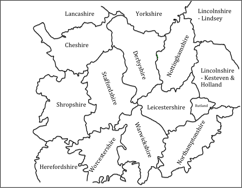
In what follows, an essentially geographical analysis will be presented in an attempt to locate the original Mercia, based on the drawing of boundaries of different types – kingdom boundaries, diocesan boundaries and county boundaries. Most of these are not contemporary with the period under consideration, and there is an implicit assumption that these boundaries reflect underlying and ancient boundaries from late antiquity. Whilst others have followed this route it is a somewhat dangerous course and open (quite rightly) to significant criticism. Also of course the concept of a boundary between peoples may or may not have been of relevance in the period under consideration and this needs to be borne in mind in what follows. These points having been made, we will in what follows use two scales of maps that both show, as the basis for relating to current geography, the pre-1974 county boundaries (see figure 1 for the larger scale of map that will be used). These counties were first defined in the 10thcentury, and remained relatively stable up to the 1974 re-organisation, although there have been continual minor modifications to boundaries over the centuries. In the area shown in figure 1, this has particularly affected the boundaries of Worcestershire, which became fragmented as a result of transfers of property from secular to ecclesiastical ownership and vice versa, with detached areas in the surrounding counties. These areas are not shown in figure 1 for clarity. There is one region however where the pre-1974 boundaries are not shown – the county boundary between the south west of Staffordshire and Shropshire – where there was an early (12thcentury) loss of land from Staffordshire to Shropshire due to the actions of Earl Roger to consolidate all his holdings into Shropshire (Thorn et al, 1986). As this region is particularly pertinent to the discussion that will follow, the Domesday boundaries for this region will be shown in all the maps that follow.
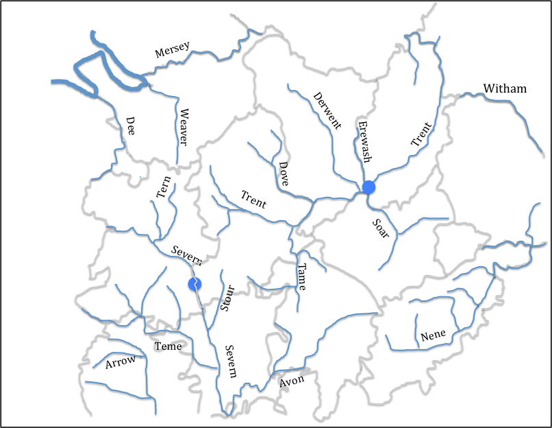
Figure 2 uses this map to illustrate the river systems in the English Midlands – and in particular the Trent, Severn, Wash and Cheshire basins. It is clear that the county boundaries in general follow river basin boundaries. In the area of interest here, this is particularly the case for the Staffordshire / Cheshire, Shropshire / Cheshire and Staffordshire/ Shropshire boundaries. The southern Severn / Trent basin boundary is also coincident with county boundaries, except in the case of Warwickshire which sits across the watershed between them.
Figure 1. The base map, showing pre-1974 county boundaries and names
Figure 2 Rivers and county boundaries
(Only major rivers and tributaries are shown. The blue filled circles indicate riverine locations of importance to the argument that follows below.)
The Tribal Hidage
The Tribal Hidage exists today in a number of different manuscripts, which are set out and compared by Dumville (1989). It essentially consists of two lists of kingdoms / polities of various sizes, with hidages attached to each entity. The date of the original document is disputed, with dates from the 620s to the 780s suggested (Corbett, 1900; Hart, 971; Higham 1995). I find the approach taken by Higham (1995), who proposes date in the 620s, the most persuasive, although this does not appear to be the universal view of historians. He suggests that it is in origin a tribute list of Edwin of Deira, dating from 624/5. The primary list is effectively a list of tributes payable to him from what Higham terms the Midlands “Overkingship”, whilst the secondary list was added perhaps a year later to indicate the tribute from the Southern “Overkingship”. The level of hidage seems to be standardized to 7000 for county sized entities, and to multiples of 300 for smaller entities particularly in the region know as Middle Anglia around the Wash and the East Midlands. For the Southern Overkingship entries in the secondary list, there is clearly a punitive element, particularly with the 100,000 hides allocated to Wessex.
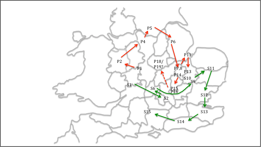
For the current purposes it is the order of the entries that is of most interest. The kingdoms on which most authors can agree are shown in figure 3 for both the primary (P) and secondary (S) lists. Original Mercia (P1 on the figure) is placed at the historic centre of the kingdom in south Staffordshire around Lichfield and Tamworth. A number of points arise from this figure.
There is a well-described clockwise progression in the primary list (and a subsidiary clockwise progression in the Fenland entities – based on the recent wok of Osthuizen (2017) and similarly in the secondary list. The latter list is indeed almost a closed loop. This is so marked, it seems to have been a specific intention on the part of the original compiler of the list.
The list includes Elmet, which was incorporated into the Deiran kingdom by Edwin (i.e. before 633) and Lindsey and Hatfield, which were never associated as a dual entity after the reign of Edwin. This argues for an early date for the Hidage (Higham, 1995).
The list does not include the Magonsaete in the south Shropshire / Herefordshire region, which was certainly in existence by 680 when it was ruled by Merewalh (note the British name), who is described by some as a son of Penda of Mercia. Again this argues for an early date (Pretty, 1989).
The area of Leicestershire and Northamptonshire, which the diocesan boundaries suggest is in Middle Anglia (see below) are not allocated any of the agreed kingdoms on the Tribal Hidage map. This suggests to me that the Noxgaga (P18) and Ohtgaga (P19) at the end of the primary list, both county sized entities, should be located in this area, rather than in the Middlesex / Surrey area suggested by some authors (Hart, 1977). This identification would make the primary list an almost closed loop.
This identification identifies the area around which the primary list loops to be in the Nottinghamshire area. This will be seen to be of relevance in what follows.
Figure 3. Tribal Hidage. “Firm” locations of regions in the primary and secondary lists
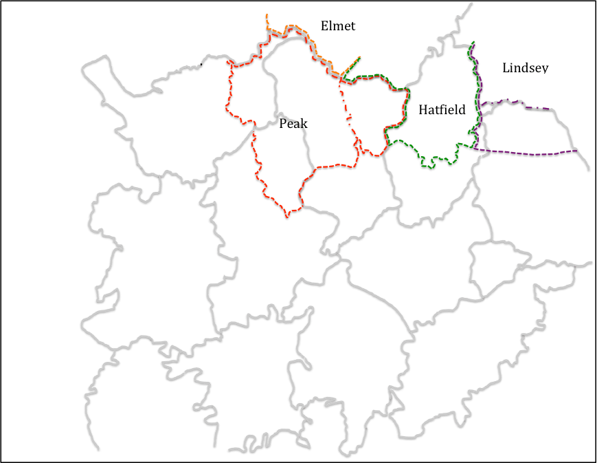
The work of local historians in various parts of England, who have carried out detailed work on boundaries of sub-Roman, early Anglo-Saxon polities that enables the boundaries of these polities to be drawn in more detail than the Tribal Hidage allows, even though these are to some extent speculative. Here we consider the work of Higham for the Pecsaetna in the Peak (Higham, 1993), Breeze for Elmet in South Yorkshire (Breeze, 2002), Parker for Hatfield in South Yorkshire / North Nottinghamshire (Parker, 1992) and Bassett for the kingdom of Lindsay (Bassett, 1989), All of these authors would, I am sure, have significant caveats for their work, but taken together they form a useful set of data. The boundaries they identify are again shown on figure 4. Higham suggests that the area of the Pecsaete consist of the Cheshire Domesday hundred of Hamestan, the Derbyshire hundred of the same name, plus the Staffordshire hundred of Totmonslow. The area of Hadfield identified by Parker includes not only the area of south Yorkshire that is usually so identified, but also north Nottinghamshire. The boundaries of the Pecsaete and Hatfield are, on this basis separated by a thin strip of Derbyshire (essentially Scarsdale Hundred), and it seems likely that the territory of one or the other of them extended to fill the gap between them. We choose here to extend the region of the Pecsaete into this area, as it will be seen below that a significant diocesan boundary separates Derbyshire from Nottinghamshire. Elsewhere the region of Elmet identified by Breeze can be seen to border on the Pecsaete, and the area of Lindsey is, following Bassett, taken to include not only the pre-1974 Parts of Lindsey to the north of the River Witham, but also a similar sized area to the south.
Figure 4 Kingdom boundaries in the north Midlands
(red dotted line shows the region of the Pecsaetna assumed in what follows – the red chain dotted line ins the boundary identified by Higham; the green dotted line shows the region of Hatfield; the brown dotted line shows the region of Elmet; the purple dotted line shows the region of Lindsey – with the chain dotted line showing the southern boundary of the Parts of Lindsey)
Now let us move to the consideration of the boundaries of church dioceses, particularly in the English Midlands. Some historians have expressed doubt about how the known medieval boundaries can be extrapolated back to the seventh century, the period under consideration here. This is particularly true of those areas which fell within the Danelaw where a number of dioceses ceased to operate. Nonetheless, they are used here for two reasons – firstly the 10th century Midland county boundaries follow these diocesan boundaries in many places and this suggests that the latter predated the former, and secondly, in many parts of the Midlands, there seems to be no record of any historical events that could have led to boundary changes. This is indeed the approach followed by Hart (1977) in his consideration of the Tribal Hidage, although he did not follow this approach to its logical conclusion.
The Mercian diocese came into existence in 655, and in its early days it covered a large region across the English Midlands. The situation changed with the reorganization of Theodore of Tarsus (Archbishop of Canterbury 669-690), who created dioceses based on “kingdoms” – a Lichfield diocese reduced in size for Mercia, Hereford Diocese for the Magonsaete (676), Lincoln diocese for the kingdom of Lindsey (678), Worcester diocese for the Hwicce (680) and Leicester diocese for the Middle Angles (681) (Podmore, 2008). These dioceses, as they existed in the late Anglo-Saxon era, are shown in figure 5, together with the relevant county boundaries (Ordnance Survey, ??).
From this figure it can be seen that the Mercian diocese covers much of west Warwickshire, Staffordshire, part of Shropshire, Derbyshire and the “land between the Mersey and the Ribble”. Clearly as such it encompasses the areas listed in the Tribal Hidage as Wocensætna and Pecsaetna, as well as whatever polities existed north of the Mersey, which must thus have been incorporated into Mercia sometime between the compilation of the Tribal Hidage (in 625 if Higham’s argument is accepted) and the re-organisation of dioceses in the 670s.
Equally significant are those areas that are not part of the Mercian diocese. Firstly Nottinghamshire has been, from at least 956 when the church was re-established following the Danish conquests, part of the York diocese (Stenton, 1968). At this time the area based on the minster church of Southwell, which was granted to Oskytel, Archbishop of York by King Eadwig. It seems likely to methat this was simply are-establishment of the pre-conquest status quo. There is a local tradition that the area was first evangelised in the early seventh century by Paulinus operating from York. Thus, in ecclesiastical terms, Nottinghamshire looks to the north and the Humber, rather than to the Midlands and the diocese of Lichfield. Secondly, the counties of Leicester and Northamptonshire are in the Leicester (i.e. Middle Anglian) diocese. Hart, in his definition of the geography of Mercia, arbitrary labels this area as “outer Mercia” (Hart, 1977), an entity which has no historical context at all. The fact that it is regarded as being in Middle Anglia is consistent with the argument set out above that the Noxgaga and Ohtgaga should be located in this area.
Figure 5 Diocesan and county boundaries.
Locating the original Mercia
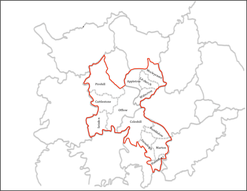
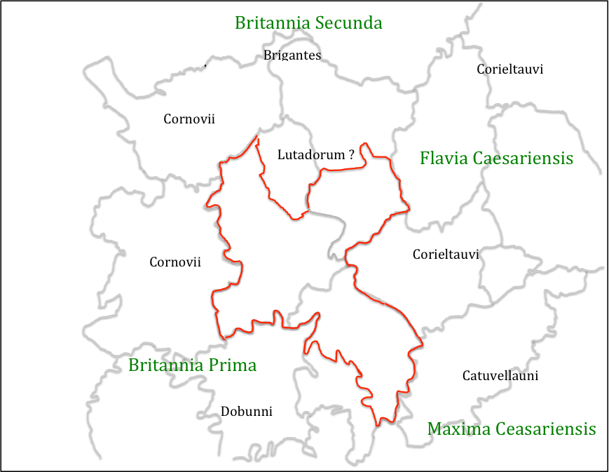
An attempt can now be made at locating the original lands of Mercia, about which the Tribal Hidage seems to revolve – see figure 6. The diocesan boundaries and boundaries of other kingdoms would suggest that this region included west Warwickshire, south Staffordshire and south and east Derbyshire. The main unknowns are the location of the northern and western boundaries. With regard to the northern boundary, this has been chosen to exclude the long neck of land between the regions of the Pecsaete and Hatfield, as identified by Higham and Parker, as this seems the more logical geographical boundary. The boundary shown in figure 6 thus forms the southern boundary of the Domesday Scarsdale Hundred. With regard to the western boundary, the logical place for this would be on the watershed between the Trent and Severn basins. This is followed by the western border of Staffordshire, except for Seisdon hundred in the south, where part of the catchment of the Stour, a tributary of the Severn, is included within Staffordshire and the Domesday county boundary was the River Severn itself. The boundary of the original Mercia is drawn to follow the Staffordshire boundary even in this region for reasons that will become apparent below. The original Mercia thus consists of the Staffordshire Domesday hundreds of Seisdon, Cuttlestone, Pirehill and Offlow (the latter containing Lichfield), the Derbyshire hundreds of Walecross, Appletree, Litchurch and Morleystone and the Warickshire hundreds of Coleshill, Bumblelow, Stoneleigh, Marton and Hunesberi. Many authors have pointed out that this region lacks natural boundaries or defensive positions of any sort, and this will be considered below. But at this point the reason for the name of the kingdom – the borderlands – becomes obvious if this area is considered in terms of the Roman Civitas, the broad areas of which are also shown on figure 7 (it is not being possible to draw these with any precision) together with an indication of the Provincial areas following the reorganization of Diocletian (Jones and Mattingley. 1993). There is coming to be agreement that throughout the fifth and sixth centuries there was some continuity in Civitas level government, at least in the west of England, either through Governors or through kings (Dark, 2000). On the presumption that something similar to these Civitas continued to exist in some form into the late 6thcentury, it can be seen that the original Mercia sat across the borders of a number of them – the Dobunni in Worcestershire and Gloucestershire, who seem to have morphed into the Hwicce; the Cornovii in Shropshire / Chester, who became the Wocensætna, the Corieltauvi in Warwickshire / Leicestershire / Lincolnshire; the Catuvellauni in Northamptonshire / Bedforshire / Buckinghamshire, and, if it actually existed, Lutadorum in the Peak District, who can perhaps be identified with the territory of the Pecsaete. It would seem that Mercia took land from all of these and straddled the borders of each, and in doing so straddled the borders of at least three of the four late Roman provinces.
Figure 6. The original Mercia mapped.
Figure 7. The original Mercia and Civitas and Provincial regions
(Civitas names in black, Provincial names in green)
The point has often been made that the original Mercia, whatever its precise location, lacked natural boundaries. However this is probably a misconception. Figure 8 shows the original Mercia as identified above, together with the established Roman road network, which was usable well into Medieval times, and also some conjectural, but likely roman roads. This changes the picture of Mercia significantly. It can be seen that the centre of the kingdom at Lichfield / Wall sits on a major junction of roads, from where small bands suitably mounted and armed could reach all parts of the kingdom very quickly and could establish control over a wide area. Also at the borders there were at least the locations of Roman towns which could have acted as regional centres – Water Eaton to the west, Greensforge to the south west, Metchley to the south, High Cross to the south east and Derby to the north. Perhaps most importantly this network would also allow control of trade across the whole region – and thus control of major trading routes across England – Watling Street between High Cross and Water Eaton; Ryknield Streets between Derby and Metchley, as well as the northern saltways from Droitwich. To this road network, can be added strategic riverine locations at Sawley – the junction of the Trent, Erewash and Soar, and on the Severn at Quatford, which could thus control major river traffic flows. The latter is the major reason for suggesting that Seisdon hundred in Staffordshire was part of the orginal Mercia, as it gave control over the saltway at Greensforge and the roads to the borders and mid Wales, as well as access to the Severn at Quatford. This interpretation thus sees the original Mercia as very much a commercial enterprise as well as one in kingdom building.
Figure 8 – Communications networks
(blue indicates probably and possible Roman Roads; red indicates locations within the Original Mercia; green indicates major locations outside this area. Blue circles indicates the riverine crossings at Quatford (in the west) and Sawley (in the east)
Finally the question arises as to whether or not there is a historical context into which the above scenario could fit. Here there is little alternative but to use the evidence of the various chronicles and early histories, and which are open to serious challenges as to their veracity and utility. With that proviso, they are used and viewed as broadly reliable in what follows.
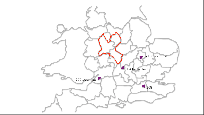
The third quartile of the sixth century was a time of expansion by the kingdom of Wessex, as illustrated in figure 9. In 568 a Wessex force led by Ceawlin and Cutha, defeated Aethelberht of Kent, and pushed him back towards his homeland. In 571, in a northern advance, Cuthwulf defeated British force at Bedcanford (usually taken as Bedford) taking control of a number of towns in that region. This was followed in 577 by the battle of Deorham, where three British kings were again defeated by Cuthwine and Ceawlin and three major towns taken – Bath, Glouccester and the capital of the Province of Britannia Prima, Circencester. Then for 584, for Anglo-Saxon chronicle reads
Ceawlin and Cutha fought with Britains at the place called Fethanleag and Cutha was killed, and Ceawlin took many townships and countless spoil and returned in anger to his own.
Here Cutha is a king in Wessex, and Fethanleag has been identified as Stoke Lyne near Bicester in north Oxfordshire – a few miles south of the southern border of Mercia shown in figure 6. Davies (1977) relates this to an entry for the next year in the Henry of Huntingdon’s Historia Anglorum which states
585 Beginning of the kingdom of Mercia, with Crida
If one can make that equation, this suggest that Cutha met his match in an essentially British force that stopped the northern expansion of Wessex, and that this force was led by Crida who then went on to establish the kingdom of Mercia as outlined above, and a dynasty in the form of Crida, Pybba and Penda. Note the partially British name of the latter, which strongly suggests a kingdom of mixed ethnicity. The dynasty was known as the Iclingas after the (perhaps mythical) ancestor Icel, and the Anglo Saxon Chronicle gives the names of his descendants before Crida as Cynewald and Cnebba. As noted by Myers there are a number of place names that reflect the name Icel across Suffolk, Cambridgeshire and Hertfordshire, and there is a concentration of names based on Pybba (Pedmore) and Penda (Pendford, Pinvin) in the Worcestershire / south Staffordshire area, suggesting the popularity of these names around there.
The nature of the original Mercia is however still elusive. It may be that Crida’s family of the 580s, simply took the region centred on Wall and held it by force of arms against the neighbouring polities. Dark would suggest that these polities were the remains of the sub-Roman Civitas system, which to the east were clearly (from the evidence of the small polities of the Tribal Hidage in the East Midlands) in the process of dissolution due to internal pressures, and perhaps also the pressure of migrating Saxons from the area around the Wash and the Humber; whilst in the west bureaucratic Civitas governments of the Dobunni and Cornovvii may well have been in their final sharp decline. This suggest the possibility (and it can be rated no higher than that) that the family and their followers were effectively foederatiemployed by these bureaucratic governments to resist the growing pressure of Wessex from the south and the chaos enveloping their eastern borders. If so, then their eventual subjugation by an expanding Mercia might suggest that this was ultimately not a good move.
In the early seventh century, there does seem to have been a break in the succession, and Bede tells us of another Mercian king – Cearl – who took the refugee and later Deiran King, Edwin, under his protection in around 605. Higham argues that he was the Midlands Overking at the time, able to resists the demands of Aethelfrith in Northumbria for the return of Edwin (Higham, 1995). The fact that Edwin was able to reach Cearl easily, and after Cearl’s death find refuge with Raedwald in East Anglia, strongly suggests that Ceorl’s activity was in the north midlands – perhaps in the south of Nottinghamshire which has been identified as an anomaly in diocesan terms. In this scenario, Cearl would have been of northern Anglian stock, but Bede would have referred to him as king of Mercia, because the region in which his power was centred was Mercian in Bede’s day. Taking this further one can perhaps see the primary list of the Tribal Hidage as a tribute list of Cearl, in which the punative 30,000 hides of the original Mercia reflected a recent takeover from the Icinglas dynasty that was not to prove permanent. It can also be speculated that Ceorl’s territory was that of the North Mercians mentioned by Bede, with the original Mercia being South Mercia. In taking over Ceorl’s territory, Penda would thus become the first king to “separate the Mercians from the Northumbrians” as also noted by Bede. But here we are in the realms of speculation, and his must be only one of many possibilities of the situation on the ground in the early seventh century.
Figure 9 Anglo Saxon Chronicle battles of the mid / late sixth century
Dumville D (1989) “The Tribal Hidage: an introduction to its texts and their history”, in: Bassett, S (ed.), The origins of Anglo-Saxon kingdoms, Studies in the Early History of Britain, Leicester: Leicester University Press, 225–230, 286–287.
Hart C (1971) “The Tribal Hidage”, Transactions of the Royal Historical Society, Fifth Series, 21 (1971), 133-157
Hart C (1977) “The kingdom of Mercia” in Mercian Studies, edited by Ann Dornier, Leicester University Press, 43-62
Higham N (1993) “The origins of Cheshire”, Manchester University Press
Higham N (1995) “An English Empire – Bede and the early Anglo Saxon kings”, Manchester University Press.
Jones B, Mattingly D (1993) “An Atlas of Roman Britain”, Blackwell
Ordnace Survey (???) “Monastic Britain”, South sheet, 2nd edition
Oosthuizen S (2017) “The Anglo-Saxon Fenland”, Windgather Press
Podmore C (2008) “Dioceses and Episcopal Sees in England – A Background Report for the Dioceses Commission”, DC/R3
Pretty K (1989) “Defining the Magonsate” in: Bassett, Steven (ed.), The origins of Anglo-Saxon kingdoms, Studies in the Early History of Britain, Leicester University Press, 171-183
Stenton F (1968) “Anglo Saxon England”, The Oxford History of England, 2nd edition, Oxford University Press.
Thorn F, Thorn C (editors), Parker C (translator) (1986) “Domesday Book – Shrops
First published on this site as a web page in April 2020, but format changed to post in August 2024 for consistency with other material
Introduction
It has been noted by a number of authors in the past that in the vicinity of Lichfield, the ecclesiastical centre of the Mercian kingdom, there are a number of place names with pagan religious associations, and puzzlement has been expressed that such names were allowed to survive by the ecclesiastical authorities (Horowitz, 2005, p32). In this article, we consider these names further and identify a small number of other sites in the locality that may also have pagan religious connections. In so doing we are led to the tentative conclusion that Lichfield may have been a centre for pagan religious activity in the pre-Christian era, and the echoes of this activity, remain in place names and church dedications in the area. This suggestion goes some way to explain the rather odd comment recorded in an early life of St Wilfred, that he gave Lichfield to Chad for the site of his cathedral in 669, as it was suitable place for an episcopal see – in that it was already an ancient cultic site (Colrave, 1927). We begin in the next section by briefly considering the work of North (North, 1997), who investigated in particular the deity known as “Ing-Freyr”, for reasons that will become obvious in what follows. We then move on to a consideration of place names and church dedications in the Lichfield area. An attempt is then made to synthesise the findings, and to draw out their implications. Finally, further possible indications of cultic activity in the Lichfield area in the Roman / British era and before are briefly mentioned.
Ing-Freyr
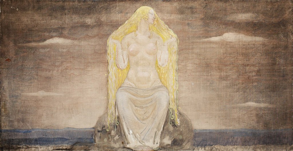
Ing-Freyr by Hugo Hamilton
Through a detailed examination of the work of the Roman Historian Tacitus who described the worship of the Angles in southern Denmark in the first century AD; the much more recent Scandinavian myths recorded in Iceland around 12thand 13thcenturies; king lists from the early English kingdoms and a range of Old English literature from the Anglo-Saxon period, North arrives at the conclusion that the worship of the deity “Ing-Freyr” can be detected in England before the conversion. He argues that the cult of Ing-Freyr directly descends from that of Nerthus, who seems to have had the attributes of a sky god, in the early Roman era by the Angles in southern Denmark. Tacitus describes this as centring on a oxen hauled wagon procession of the god, either represented by an idol of by a nominee, around the tribal region, with the celebration of a marriage to the earth goddess Terra Mater, symbolised by copulation with local women or with a nominated female. This rite had obvious fertility aspects, and also seems to have involved the “death” of the God (either through the symbolic interring of the idol, or perhaps through human sacrifice) after the wagon tour, and his resurrection in the following spring. The suffix “Ing” can be found in a number of early Anglian king lists, indicating the persistence of the cult into the Anglo-Saxon era and can be traced through various Old English texts. Freyr simply means “Lord” and in the Nordic myths was the son of Njoror (the equivalent of Nerthus) and the brother of Freyja, who were all members of the Vanir, the old gods who were the losers of a cult war with the Aesir headed by Odin. The name Freyja simply means “Lady” and is widely regarded as a fertility deity, and also as a “psychopomp” who attended to the souls of the dead. In some myths she is identified with Frigg, the wife of Odin The concept of a dying and rising God has of course resonances with Christianity, and North, somewhat mischievously, writes
…the Angles, in particular, offered no resistance to Christianity and indeed failed to perceive the difference between the new religion and their own…. (North, 1997, 305)
However, whilst the cult of Ing-Freyr could clearly have played a part in the conversion of the Angles, ultimately for the Church there was the possibility of much confusion with the orthodox faith that was potentially very damaging. There is some evidence that the Church thus came to equate Ing-Freyr with the devil (North, 1997, 56-57, 325), and the cult was firmly suppressed. This was partly achieved through his replacement in king lists and names by Odin, an ambiguous figure, both a deity and a real or semi-mythical Swedish ancestor, but who was clearly not regarded as a threat to the church in the same way as Ing-Freyr[vi]. One of the attributes of Odin himself was that of the psychopomp.
Whilst the arguments of North are based on widely diverse sources, both in terms of content and date of composition, they are nonetheless cogently argued and present a convincing case that, in the pre-conversion era, the cult of Ing-Freyr could be found amongst the Anglian peoples of Britain. The implications of this for the Lichfield area will become clear in the following sections.
Place names and Church Dedications
The name of Lichfield itself remains something of a mystery (Horowitz, 2005, p16). The early (medieval) understanding, based on the writings of Matthew Parris, a monk of St Albans, was that it carried the meaning “Field of the dead” and was the site of the martyrdom of Christians during the persecution of Diocletian from 284 to 305, with “Lich” being derived from the Old English word for body or corpse. Early spellings of the name however suggest that such an interpretation is at best debatable, and the accepted wisdom is that the name derives, through a complex system of intermediate forms, from the Celtic word that evolved into Letocetum (Wall) in the Roman era, and means the open place by the grey wood (Horowitz, 2005, p17). What the grey wood might be has however not been explained, although of itself it to some degree numinous, with perhaps some symbolic meaning and content relating to the dead or the supernatural.
If the name of Lichfield cannot be fully explained, other names in the vicinity are less ambiguous. There are two “Woden / Odin” names to the west – at Wednesfield (Horowitz, 2005, p566) and at Wednesbury (Horowitz, 2005, p565), with names that mean the open land dedicated to Woden, and Woden’s fortification respectively. A little way to the east, on Watling Street, we find Weeford – the ford of the idol or shrine (Horowitz, 2005, p29). Less certainly, in between Weeford and Lichfield, we find Freeford (Horowitz, 2005, p32) (Horowitz, 2005, 30), . Whilst this might simply mean free, or unrestricted, ford, a possible variant is Freyja’s ford, which, in view of the theories of North set out above, may well be of some significance. Weeford and Freeford were two of the five original (and quite possible pre-Domesday) prebends of Lichfield Cathedral, the others being Longdon and Handsacre to the west, and Stotfold or Statfold to the east.
Freja (1905) by John Bauer
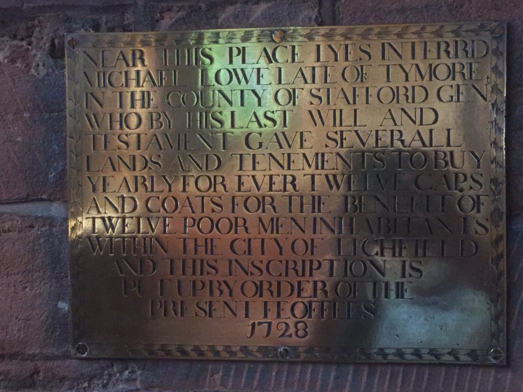
However there are a small number of other sites that may have connections with pagan worship in the area. The first is the last of the five prebends just mentioned. Stotfold (Horowitz, 2005, p510) carried the meaning of (horse or oxen) stud fold. The horse itself had ritual significance in the Anglo-Saxon period, but it is the possible association with oxen that is clearly of significance to the current discussion. Also, just to the south of Freeford we find Ingle Hill (Horowitz, 2005, p336). Horowicz is not certain on the derivation of this, offering a rather tenuous connection with the Inge family who were apparently in the Lichfield area in the 18thcentury. The root however is exactly the same as Ingham in Lincolnshire, Norfolk and Suffolk (all regions of Anglian migration), which does seem to be connected to the deity Ing (Mill, 1991). We thus have the names Weeford, Freeford, Stotfold, and Ingle Hill all in close proximity, and whilst the derivations of all but the first are arguable, their geographical coincidence strongly suggests a connection with pagan ritual. All these places are also part of a large land unit that was eventually to become the Domesday manor of Lichfield, and then the large parish of St Michael’s Church on Greenville (James, 1998). Basset (1992) argues that this was actually a pre-Augustinian British Diocese, and whilst this may be possible, it may be simply a land unit that arose for different reasons. Finally, there is the possibility that one of the members of the Domesday Lichfield land unit, Tymmore (whose meaning has not been addressed by place name scholars) could refer to the god Tyr, the moor in question perhaps being Whittington Heath to the east of Lichfield (Morris, 1976). Place names thus suggest an unusual level of pagan activity or memory in the Lichfield area in the period from which the settlement names derive
Memorial plaque to Michael Lowe of Tymore in St Michael’s church, Lichfield
Within Lichfield, there are three parish churches and the cathedral. Bede tells us that the latter was originally dedicated to St Peter and St Mary (Kettle andJohnson, 1970), but at least by Domesday, the dedication was to St Chad and St Mary. Thus the dedication was to the “Lady” of the Christians and to the chief apostle, and latterly to the major local holy man. The three churches are dedicated to St Mary, St Chad and St Michael. The first was a medieval creation for the planned town of Bishop Roger de Clinton in the 12thcentury. Of the latter two, the land unit evidence discussed by Basset suggests that St Michael’s is the older, and that St Chad’s parish was originally included within it (as were the parishes of St Mary’s and the Cathedral Close). In St Michael we have both the angel who threw the devil to earth from heaven, as well as the Christian psychopomp. The huge size of St Michael’s graveyard has frequently been pointed out, and whilst this size may be purely functional, it might nonetheless indicate early association of the area with the concerns of the dead (James, 1998).
Of the three prebends of Lichfield discussed above, Freeford and Stotfold have no chapels of their own and seem to have always looked to St Michael’s as the mother church. The church at Weeford is again dedicated to Mary. Away from Lichfield, there does not seem to have been an ancient church at Wednesfield, but at Wednesbury the hilltop church is dedicated to St Batholomew. Interestingly there are two other Bartholomew dedications in the vicinity – at Hints on Watling Street near Weeford to the east of Lichfield, and at Farewell to the west. Bartholomew is one of the lesser known of the disciples in biblical terms, but one of his traditions relates that he was martyred by being skinned alive. He is regarded as the patron saint of tanners, which is perhaps a tenuous connections with the ox wagon procession that is identified herein. He is also identified with Heracles, perhaps through a similarity of iconography, with Heracles holding the skin of the Nemean lion in a similar manner to Bartholomew holding his flayed skin (Crane and Lazzarotti, 2014), and through Heracles / Hercules to Balder, the dying / rising God of Norse myth, which is shown by North to be identified with Ing (North, 1997, 143).
Finally the church at Shenstone to the south of Lichfield, is dedicated to St John the Baptist, whose feast day is on midsummer eve. There is a long and proven European tradition of midsummer bonfires on hilltop sites (possibly where bones were burnt) that goes back to Roman times (Hutton, 1996), and the dedication to St John suggests that these occurred at Shenstone, and might go some way towards explaining the rather curious name (Horowitz, 2005, 488), which means “Shining Stone”. There are no obvious stones to which this could apply in the vicinity, but the name could conceivably apply to an idol illuminated by a bonfire.
Synthesis
At this point it would be easy to fall into wild speculation concerning the implications of all the above, and perhaps particularly on the route that might have been taken by an ox drawn idol bearing wagon. We resist that here and simply emphasise two major points. The first is that place name evidence strongly suggest that the region around Lichfield was the centre of a cult of Ing-Freyr, and perhaps Freyja, with some indications that the ancient wagon procession cult was at least remembered if not wholly practiced – the names of Freeford (Freyja’s ford), Ingle Hill (Ing- Hill), Weeford (Idol ford), Stotfold (Oxen or horse fold) and perhaps Shenstone (Shining Stone). This implies the early existence of both a fertility cult, with an annually dying and rising deity, and with a cult of the dead. The second point is that this cult seems to have been supressed in exactly the way that Pope Gregory recommended to St Augustine – to use and hallow the pagan shrines for Christian worship. The three pagan sites of Weeford, Freeford (which includes Ingle Hill) and Stotfold were eventually to become prebends of Lichfield Cathedral; the worship of the Lord Ing-Freyr and the Lady Freyja was replaced by the worship of Christ as mediated through the chief apostle Peter and the local holy man Chad, and “Our Lady”, the Virgin Mary. The pagan psychopomp Freyja was replaced by the Christian version, the Archangel Michael, who from the summit of Greenhill would proclaim the Christian victory over the Lord and Lady of the Vanir. Away from Lichfield itself, the fires at Shenstone, that perhaps used to illumine the travelling idol, became dedicated to St John, and whatever occurred at Wednesfield, Wednesbury, Hints and Farewell was neutered using the ambiguous name of Woden / Odin, and the rather dramatically martyred St Bartholomew. But the suppression was not wholly complete. Some of the names in the vicinity were too deeply ingrained in the local consciousness to be eliminated completely, and the association of Lichfield with both the cult of the dead and with fertility was to endure, through the long history of the graveyard at St Michaels, and through the Greenhill Bower respectively. Interestingly, and perhaps amusingly, as late as the 14thcentury the incumbents of the (once pagan) prebends of Freeford, Weeford and Stotfold still appointed chaplains to the three (Christian) city churches of St Mary, St Chad and St Michael (Greenslade, 1990).
In the above no attempt has been made to give chronological depth to the above suggestions and give suggested dates other than the firm one of 669 for the beginning of Chad’s episcopate. Place names and church dedications simply do not allow a precise chronology of the interaction between pagan and Christian worship to be developed. So we have simply set out the evidence that suggests that, in the pre-conversion period, there was a significant and identifiable pagan activity in the Lichfield area, that had both fertility and mortuary aspects, and was ultimately supressed, albeit far from effectively, by the Christian church.
Earlier possibilities
We have concentrated above on the interface between Anglian pagan worship and Christian worship, potentially in the sixth and seventh centuries. However there’re a number of indications that the Lichfield area might have cultic past that goes back further than that. James (1999), based on the work of Morris (1989), argues that the church dedication to St Michael on Greenhill could have displaced an earlier cult of Mercury, who has many of the same attributes, including that of psychopomp. In turn this could be related to the cult of the Celtic / British deity Lugos, who again had the same attributes. Also, as noted above, Bassett (1992) argued that St Michael’s could have been the centre of a late Roman ecclesiastical diocese. How the various competing cultic sites of the Roman / British and Anglo-Saxon periods might have related to each other is not at all clear.
Going back still further, it is quite possible that Lichfield itself is part of a major solar alignment, with the Cathedral, St Chad’s Well, and the Bronze age site at Catholme all being on a midwinter sunset / midsummer sunrise alignment. The cultic implications of this are the subject of speculation is a related blog post.
References
Basset S (1992) “Church and diocese in the West Midlands; the transition from British to Anglo-Saxon control”, in Pastoral Care before the Parish, ed. J. Blair and R. Sharpe (Leicester University Press), pp13–40.
Colrave B (ed) (1927) “The Life of Bishop Wilfred by Eddius Stephanus”
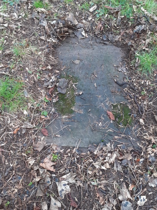
In a recent post I set out what we know of Elizabeth Logan, a nurse who swerved with Forence Nightingale in the Crimea and who is buried in St Michael’s churchyard. Towards the end of the post I wrote
” In addition, sadly, her grave can no longer be positively identified, and there are a number of broken or very worn monuments in the region where a1984 survey by the Birmingham & Midland Society for Genealogy & Heraldry (Midland Ancestors) suggests it is to be found.”
Thankfully her headstone has now been found, not by me, but by my wife who took all of 60 seconds to find what I had spent several hours looking for. My only excuse is that I was looking for a reasonably vertical headstone rather than one laid flat and half buried under grass – see the photo below. It can be seen to be in rather poor condition, and clearly some thought needs to be given as to how it can be better cared for and displayed.
The paper summarised in this blog, and another on a different topic that was written around the same time, were originally intended to be sent to journals for publication – after five years of retirement I felt able once again to resume my career long warfare with journal editors and referees. However reading the journal author guides quickly made me change my mind, and I decided simply to mount the papers on this website. This has advantages in that doing so is good for my blood pressure and state of mind, and also allows for immediate dissemination of what has been written, but also disadvantages, in that the papers have not been tested by peer review and, as I am possibly the world’s worst proof reader, no doubt have significant numbers of typographical errors. Readers will come to their own views as to whether my approach has been the correct one.
Outline
This post links to a paper that analyses the burial registers of St Michael’s church in Lichfield over a 200-year period from 1813 to 2012, together with the memorial inscriptions for that period found on graves in the churchyards. It is written in a deliberately academic style, which probably restricts its audience somewhat, and is very technical and statistical in its approach. Indeed, it is based on a collated spreadsheet analysis of all burial register entries, grave location records and monumental inscriptions. It summary, the analysis shows that over the first 150 years of the study period there was a remarkable stability in interment and funerary practices, but in the final 50 years there was a very major change. We will consider these in outline in this post, but full details can of course be found in the paper.
Over the 200 year period, the age profile of those interred changed in accordance with national trends, with a marked reduction in infant death rates, and an increase in deaths in the older age ranges – see figure 1 for female deaths for example.
Figure 1. Female interments by age 1813-2012
The biggest change to occur in the study period has been the change from burial to cremation as the major mode of interment – the national and St Michael’s percentage are sown in figure 2. It can be seen that St Michael’s lags significantly behind the national trend, not least because proper arrangements were not made for the interment of ashes until 1979 when a Cremated Remains area was set out.
Figure 2 National and local percentage of cremations
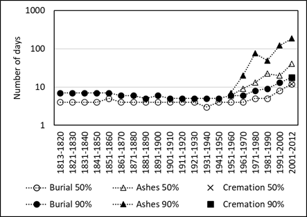
The interval between death and interment was remarkably stable up until the 1950s, with a 50th percentile value of 3 to 4 days, and a 90th percentile value of 6 to 7 days (figure 3). However in the 1960s, these values began to increase., and by 2012 the 50th percentile of the interval between death and burial was 12 days, and between death and interment of ashes following cremation was 41 days. It is conjectured in the paper that this increase for both burials and interments. has been driven by the need to arrange a time for the crematorium service. These changes have profound effects on the nature of the mourning process. By the time of the funeral the families have passed through the first acute stage of grief and have become much more active in planning and conducting the funeral itself.
Figure 3. 50th and 90th percentiles of intervals between death and burial (1813-2012), interment of ashes (1960-2012) and cremation (2001-2012)
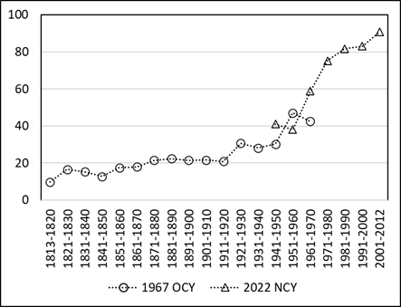
Associated with this, the percentage of graves with headstones or other monuments has increased significantly since the 1960s, from around 20% of al interments up till then, to around 90% by 2012 (figure 4). The nature these inscriptions has changed too, with family relationships becoming the primary subject.
Figure 4. Percentage of graves with monuments in both churchyards 1813-2012
Taken together, I argue in the paper that the data is consistent with earlier work by others that indicates the focus of interments and funerals has moved away from concentrating on the Christian message of resurrection and eternal life, towards celebration of the life of the deceased, primarily in the context of the family.
From the Staffordshire Advertiser January 13th 1923.
St. Michael’s Church. Lichfield. New Vestry erected at a cost of £1,200
On Sunday evening the large and commodious vestry which has recently been erected at the south east corner of St. Michael’s Church, Lichfield, to replace the small and inadequate room utilized by the clergy and choir in the past, was dedicated by the Archdeacon of Stafford (Rev. High Bright) in the presence of a large congregation.
At the morning service the Rector (Rev. Percival Howard) took advantage of the opportunity to refer to the important improvement which the vestry has made to the church, and in the course of an appropriate address outlined the course of the restoration of the church in the years 1842 and 1890 ……….
There follows a very lengthy description of all the alterations made between 1842 and 1892, before finally returning to the matter in hand.
…….. Since then no structural alterations had taken place until last year, when the Parochial Church Council decided to put in hand the building if a new vestry. This work has now been completed under the direction of Messrs. Bateman and Bateman, Architects, by Messrs. R. Bridgeman and Sons, and in place of the old and inadequate vestry, a large and commodious room has been created, which the Rector thought they would all agree was a handsome addition to the church, and in perfect keeping with the rest of the architecture. To prevent the smoke and fumes entering the church, considerable alteration has also been made to the flue. The whole of this work, which had cost £1,200, has been carried out without an appeal thanks to the generosity of their forefathers, who had left an endowment for the benefit of their church.
Following the dedication on the evening, the Archdeacon preached from the text “Seek ye My face! My heart said unto me, Thee, they face Lord, will I seek (27th psalm, 8th verse)
The congregation included the Mayor (Councilor J. H. Bridgeman), the Sheriff (Mr W. E. Pead), the Town Clerk (Mr W. Brockson) and a number of other leading citizens.
It is tempting to think that the alterations to the flue were to remove the smoke and fumes generated by the clergy and choir, but these were probably something to do with the boiler house beneath the vestry! And for all the praise heaped on the design, the roof has leaked continually over the last 100 years.
Of the people mentioned, the mayor, J.H Bridgeman was the son of Robert Bridgman, who was an earlier mayor and the founder of the Ecclesiastical Architects Robert Bridgman and Sons. The firm had many local commissions including the east front of the cathedral. Both Robert and John are buried in the churchyard. Mr Pead, the Sheriff wrote a lengthy war diary describing the war in Lichfield, that was published and is available on Google Books. The Rector at the time, was Percival Howard (Rector 1913-1946), who served as an army chaplain in the Great War, and reports of his leaving presentation suggest he was highly regarded in the parish. There is a memorial to him in the chancel.
But after a hundred-year life, changes are in the air. The new parish rooms are intended to be connected to the church through the choir vestry, so that part of the church will see major changes in the next few years. But a hundred years for £1200 still represents pretty good value for money.
In the records of headstone inscriptions for St. Michael’s churchyard in Lichfield, we find the following entry.
Sacred to the memory of Elizabeth Logan who died February 28th 1878. Having acted with Miss Nightingale in the Crimea on her return she followed the profession of sick nurse for which she was eminently qualified by her skill and experience. A strong sense of duty and great kindness of heart. No one who witnessed her self—denying exertions in aid of suffering humanity could ever forget them. Well done good and faithful servant. Thou hast been faithful over a few things, I will make thee ruler over many things. Enter thou into the joy of thy Lord.
The burial register tells us that she was 66 when she died and the register and lived on Dam St. In the 1861 census she is recorded as a nurse, lodging with a greengrocer and his wife on Market Street. She there identifies herself as “Mrs” and her birthplace is given as Glasgow. This leads me to conjecture that she was widowed before she went to Crimea, and probably had no children, although there are lots of other possibilities of course.
In the records of Miss Nightingale’s nurses she is noted as coming from Edinburgh and having been recommended by “Dr Simpson and others and committee of Nursing home” and was “one of the very best nurses, returned on the Ottawa, July 1856”. Florence Nightingale writes of her to her friend Lady Cranworth, from the Barrack hospital at Scutari in early July 1856.
My probable last letter to you is merely to say that Elizabeth Logan, nurse, whom I have sent home by the Ottawa is, on the whole, the one I consider the most respectable and sober, efficient, kind and good of all my nurses, the one I most hope not to lose sight of, the one I have the deepest regard for. She wishes for a private situation. If she comes to you for a character, I think you may be perfectly safe in recommending her. She is an excellent nurse.
Praise indeed from such as she. We read of Elizabeth briefly again in August 1856 when she wrote to Miss Nightingale saying her wages had not been settled (one presumes by the army), and in February 1857 when she wrote thanking her “for the Sultan’s gift and for her help in securing her present agreeable situation”. Would that we knew what the gift and her situation was!
And that is about as much as we know of her. The fact that she was probably a widow with her husband’s name makes her very difficult to trace through the census and baptism and marriage registers. Indeed Elizabeth Logan is not an uncommon name in Glasgow and Edinburgh around that period. So we have no details at all of her early life, or what she did when she returned from Crimea, other than that she finished up in Lichfield. In addition, sadly, her grave can no longer be positively identified, and there are a number of broken or very worn monuments in the region where a1984 survey by the Birmingham & Midland Society for Genealogy & Heraldry (Midland Ancestors) suggests it is to be found. But the presence of her grave in the churchyard does balance to some degree the many soldiers graves found there, including of those who fought in the Crimean War.
So to end with a plea – if any reader can provide any more information about her life, it would be hugely appreciated.


