
This website
The churchyard of St Michael on Greenhill in Lichfield is very large and of some antiquity, with indications that it was a place of worship well before the Conquest. Today it comprises two sections – the old churchyard, which was formally closed to new burials in the late 1960s, and the new churchyard, which opened in 1944 and is still in use, although burial space is becoming very restricted. Both contain numerous graves and monuments and are of considerable interest to both historians and those involved in family history research. This webpage thus collates a range of material from Burial Registers, Grave and monument surveys etc. into a downloadable spreadsheet that it is hoped will prove of interest and use to family history researchers and to others. This has been a very considerable task requiring a complex analysis of the sources, and it is inevitable that there will be errors or omissions. If the reader comes across anything that looks odd, do let me know on bakerc54@gmail.com and I will investigate.
The churchyards
An outline plan showing the two churchyards is given in figure 1 below.
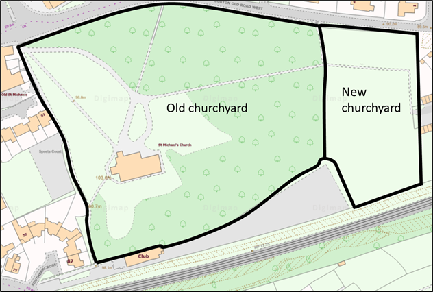
Figure 1. The two churchyards
The old churchyard has been in use for many centuries and became full in the 1950s and 1960s. At that time the decision was made to close the churchyard, and hand over maintenance to the local council. To make this easier, there was a major reconfiguration of the churchyard in the late 1960s, with many gravestones being moved into clusters, and many kerbs being buried. Parts of the churchyard became very overgrown, but in recent years a management plan has been put into place to develop areas of wild-flower meadow, plant new trees and more proactively manage the area for flora and fauna. Occasional burials or interment of ashes have continued to take place since closure with the opening of existing graves.
The new churchyard was opened in 1944 is still (in 2022) in use and contains rows of graves, most of them with memorials. There is also a Cremated Remains area, It is in general well-kept and maintained, although ground movement has affected some graves.
Records and registers
There are a number of records and registers that are available as follows.
- The results of a 1967 Council survey of all the graves in the old churchyard that were then visible that identified their location, and transcribed names and dates of death. Around 2100 graves with 3600 individual burials were identified at that stage.
- A survey of Monumental Inscriptions carried out by volunteers from the Birmingham and Midland Society for Genealogy and Heraldry (BMSGH) in 1984 and available on CD, that identified around 1600 graves in the old churchyard and 600 in the new churchyard.
- Burial registers dating back from 1813 to the present. Those from between 1813 and 1940 have been transcribed in the past and are again available on CDs produced by Burntwood Family History Society. Only the index information is provided for the period from 1905 to 1940.
- Photographs of the visible gravestones in both churchyards taken between 2020 and 2022.
This website builds on these sources. The 1967 and 1984 surveys have been collated and the latter has been very considerably extended to include memorial inscriptions up to 2012. A significant number of what appear to be typographical errors in both surveys have also been corrected (and no doubt others introduced). The registers from 1940 to 2012 have also been transcribed and more information added to the earlier transcription from 1905 to 1922. The debt to those who produced the original surveys and inscription transcripts remains significant.
Linked files
We present this material on three separate pages that can be accessed from the buttons below.
- A document that contains maps and plans that define the positions of graves and monuments from the 1960s to the present. The situation is complex, with a number of different classification systems used over the decades.
- A further document containing photographic reproductions of the plans of the 1967 survey
- A document which describe the current state of the various grave areas and clusters within both churchyards and contains photographs of the more notable monuments.
- The spreadsheet itself that contains all the above information in a searchable format.
Photographs
Because of web site upload limits, it is not possible to upload all the photographs that have recently been taken of the monuments and headstones. However, any particular photograph can be obtained by emailing me on bakercj54@gmail.com
