In 2021 I discussed some of the early graves in St. Michael’s churchyard in Lichfield. Amongst these was the distinctive “saddleback grave” shown in Figure 1 below, one of the five listed monuments in the churchyard. At the time I wrote as follows.
The inscription is very worn and the dedication of the monument can’t be read. This grave features in a nineteenth century drawing that is in the William Salt library ……. That drawing gives the date of the grave as 1674, and with a little imagination this can be made out on the tomb itself. Apart from the date, it is the style of the grave that makes it so distinctive. It is a shame that the dedication is illegible.
Figure 1 The Saddleback grave in 2021
And this is where serendipity comes in. Over the last few days I have begun to think about filling in some of the gaps in my long term project to collate the memorial inscriptions of St. Michael’s churchyard with the burial registers – specifically to include material from the early registers up to 1812. A very helpful archivist at Staffordshire Archives told me that these have been scanned and can be found on Find my past. So I have been busy doing some mass downloads of the material during my seven day free trial (as you do). Whilst doing this I came across the sketch shown in Figure 2 in the register from 1680-1741, on a blank page opposite the entries from November to March 1691 (note this was before the calendar change!)
Figure 2. The sketch from the 1680 to 1741 Register
It clearly shows the Saddleback grave and gives the inscription as
Here lyeth the bo… of James Allen Esq…..1677
There is another note in lighter script that says
Illegible in 1891
So it seems we have an identification of the occupant of the Saddleback grave – although the date is given as three years later than indicated on the William Salt picture. Checking back on the records however in the 1574 to 1680 register, the only entry that corresponds to the name is from 1674
April 13th Mr James Allen, Magistrate, Beacon St
Beacon St is somewhat conjectural however – it is not easy to read. So it looks as if the William Salt date is the correct one.
The registers tell us little else. There is an entry for the marriage of James Allen (Gent) to Mrs. Hester, daughter of Richard Pyot (Dyot?) in November 1658 at St. Mary’s which seems possible. However this was in the Civil War / Commonwealth period when records become very patchy, so there may have been other about with the same name. If any reader knows more of James Allen, then please let me know. But a least we now have a name.
In the monograph “Oakham Lordshold in 1787”, Clough (2016) considers the map of the town of Oakham in Rutland produced for Lord Winchilsea in that year. This is the earliest map to show significant detail of the urban topography of the town, and from it Clough was able to infer some aspects of its late Anglo-Saxon / early Norman topography, in particular the existence of two enclosures encompassing the castle and the church, and the castle and a large portion of the town. In this post. I take his considerations somewhat further and, by considering the likely Anglo-Saxon road network around Oakham, infer some further features of the Anglo-Saxon urban topography.
Oakham connections
Cox (1994) in his extensive survey of Rutland place names, identifies a number of settlements in the Oakham area that were likely to have been in existence in the sixth and seventh centuries i.e. early on the Anglo Saxon era. These are as follows.
Place names ending in -ham, meaning village or estate. These include Oakham itself; Langham and Wymondham to the north west; Greetham and Grantham to the north east, Empingham to the east and Uppingham to the south.
Place names ending in -dun meaning a large hill, of which the only one in the vicinity of Oakham is Hambleton.
Place names associated with the Anglian tribe of the Hwicce of which Whissendine to the north of Oakham is the only one locally.
The villages of Brooke, which has an early attestation, and Braunston, which incorporates an early form of Anglo-Saxon name and has possible Roman antecedents.
The -well names meaning spring, and in particular Ashwell, although this might be slightly later than the others.
The major settlements in the wider region either with proven continuity since the Roman period or are of an early form- Leicester, Nottingham, Lincoln and Stamford.
In what follows we presume that in the Anglo-Saxon and Norman periods, Oakham had road / pathway connections to these early settlements that are, broadly, the predecessors of those we see today at least out of the settlements themselves. Country roads are very conservative topographical features and change little over the centuries. Within, and on the entry to settlements, they would however have been more prone to change, because of building and commercial developments. In these terms we will consider seven such roads that converge on Oakham and in particular we attempt to trace the “natural” course of these roads into and through the town, again assuming that these are the courses that would have been followed in the Anglo-Saxon period, rather than the courses that have developed over the centuries.
But first a broader point is worth making. Oakham was in the ninth and tenth centuries was in many ways at the centre of the Danelaw, with roads passing through it that connected Leicester in the west to Stamford and Lincoln in the east, and Northampton in the south with Derby and Nottingham in the north. As such, it is likely to have been of some strategic importance, particularly during the period when King Edward and Lady Aethelflead finally defeated the Danish armies in the area between 910 and 920.
The Anglo-Saxon roads
The roads that we are considering are shown in Figure 1 on a copy of the 1787 map as given in Clough (2016). These are as follows.
Figure 1. The proposed early road layout
Road 1 from Belton and Braunston (and beyond that Leicester) that runs up what is now Braunston Road and West Road (formerly known as Cow Lane) and joins Road 2 to the west of Oakham.
Road 2, the current Cold Overton Rd from Knossington, runs in a west to east direction, across what would become many centuries later the railway crossing and into Oakham. If the line of the road is continued, it runs along Dean Street (A) towards the church (B), and not along High Street. This straight alignment is very clear from the satellite view of figure 2. I will argue below that High Street was a relatively late development and was laid out in the Norman period. I have then shown the road running to a point in the current market place (C) in front of the castle (D) although this last stretch is conjectural.
Road 3 is the road from Melton Mowbray (and Derby and Nottingham beyond) through Wymondham and Langham. The modern approach to Oakham is via a sharp 90 degree turn along the railway down towards the level crossing. It will be seen below that this route was actually in place in the 16th century at the latest, so it is not a modern development. However, here we take the natural line of the road to continue from the north of the area marked as the Parks (E) towards the sharp kink in the modern Northgate (F) and then following Northgate and Church Alley to a junction with Road 2 in the Market Place. Again, this natural course is very obvious on the satellite view of Figure 2. This seems a much more natural route into the centre of the town.
Road 4 is from Ashwell and Greesham (and beyond that Grantham) that is taken to follow the existing course of Burley Rd. east of the castle to a junction with Road 5.
The course of Road 5 from Stamford and Empingham has changed significantly over the centuries, as it was moved to loop around Catmose Hall. Clough conjectures that it used to entire town through either or both of Bull Lane (G) or Tanners Lane (H) to the north of Bull St. We choose the latter course here as it allows this road to meet those from the west in the Market Place.
Road 6 from Uppingham and Preston follows its modern course to the end of Mill St. (J) and then cuts across to meet the other roads in the Market Place,
Road 7 from Brooke and Riddlington follows the current course of Mill St. to a junction with Road 6 (J).
Figure 2. Satellite views of the western and northern approaches
The Saxon / early Norman enclosures.
Figure 1 also shows two enclosures. The black dotted lines is a (very) conjectural boundary of the Anglo-Saxon settlement, based on the discovery of boundary ditches at K, L and M summarised by Clough. The purple solid line is the enclosure surrounding the castle and the church identified by Clough, largely on the basis of the flooded ditch at N (that has also been identified in archaeological investigations). Taken together these two enclosures would seem to represent the extent of the Anglo—Saxon and early Norman settlement. The strategic and defensive position of the castle (and in particular the Motte in the south east corner P) adjacent to the meeting point of the roads through the town is very clear. The most striking point about the proposed reconstruction is the absence of the High Street – its anomalous orientation with regard to the other roads suggests it postdated the original road layout. South Street was however likely to be in existence early as it marks the southern boundary of the enclosure. Note its original course ran straight from the west to the east, and did not diverge to the south east at its eastern end.
Changes in the Norman period
Figure 3. The post-conquest road layout
Figure 3 shows the road system and enclosures in the later Norman period. Clough identified the enclosure outlined in green that contains the castle and the portion of the town to the south. He speculates that the pattern of enclosures was changed when the manor was relinquished by (probably) William II and divided between Lordshold and Deanshold (the Dean referring to being that of Westminster Abbey), with the results that the church and the castle holdings were separated. This enclosure was again identified on the basis of a flooded ditch at Q. Clearly the function of this enclosure is very different and seems to be about controlling the movement of people and goods through the town (presumably for taxation purposes). It is like that this is the period when the current High Street came into existence. The Speed map of 1611 (Figure 4) shows “Bargate” at R, (built into the current Flores House) where presumably people and goods were assessed . The road system has also been changed to ensure all traffic flows along High Street. In the west, Road 3 was rerouted, probably in the first instance to follow the current line of Park Lane (S) down to Road 2. At some point the area named as the Parks was enclosed (both routes are shown on the 1611 map), and the route would again have been changed to run around this area, resulting in the modern road configuration (T). The current traffic chaos around the level crossing on the Cold Overton Road thus has its genesis many centuries ago! The combined roads 2 and 3 were then rerouted along the new High Street, rather than down Dean Street. To the east, it is likely that the Stamford Road was rerouted to come into town via what is now Bull Lane.
Figure 4. The Speed map of 1611
Loose ends
In this final section we note a number of what might be called loose ends in the above argument – the lack of destinations for one of the identified roads; the lack of direct roads from a significant place in the locality and the nature of the town “gates”.
A road to nowhere
Road 2 approaches Oakham on a straight route from the west, and within the town becomes Dean Street. But where was it coming from? There are no settlements out in that direction that can be confidently given an early date. Two thoughts come to mind – either that it was part of a somewhat roundabout route to Leicester, or that it was the route to what can be surmised to be early fortifications of the Rutland border to the west (where a number of names indicate beacons). There are no doubt other possibilities.
The route to Hambleton
There are clear indications in Domesday that the major settlement in the area at the time was Hambleton, and it was suggested above that this settlement was of an early date. As far as can be ascertained from the fairly recent maps that are available, the route there was a 90 degree junction of the Stamford Road (see the 1900 Ordnance Survey map of Figure 5). However the map shows a pedestrian way to the west of the junction that cuts of a corner and is a much more natural way to Hambleton. It seems possible that the Stamford Road bifurcated at that point with branches to Empingham and Stamford to the north and Hambleton and Ketton to the south, but that this junction was supressed during the enclosures. So Road 5 might better be referred to as the road to Hambleton, Empingham and Stamford
Figure 5. The road to Hambleton (from 1900 Ordnance Survey map
The gates
“Gates” is an ambiguous word. It can either refer to a physical gate to the town, or be a derivation from the Norse -gata simply meaning road. Bearing this in mind, Clough identifies two gates – an East gate at the entry of the Stamford Road into the enclosure around the present Bull Lane, and a West gate – the Bar-gate mentioned above. The road system was clearly arranged to direct all traffic through these, and resulted in quite a small central enclosure.
Now, whilst no south gate has ever been identified, from the earliest maps, there is a Gibbet Gate shown on the Speed Map on Stamford Road (Figure 4). This is someway outside the enclosed areas, and is this case the word gate probably simply defines a road rather than anything else. albeit one leading to a somewhat grisly destination.
The name Northgate, however, appears on a number of maps. On the Speed map this is positioned somewhere near the railway crossing, and on later maps, the current Northgate is known by either that name or by Northgate Street. Again, this could either refer to an actual gate to the town, or simply a way to denote a road. But if there was an actual North Gate, where was it? In my view, the most likely position is at the current sharp junction of the modern Northgate – F in figure 1, on the original Melton Road and at the possible confluence of the Saxon town and Castle / Church enclosures. A modern photograph is shown in Figure 6 below – taken from the east showing the possible location of the north gate (the thatched cottages) and the line of the road from there to the castle.
Figure 6. The possible location of the north gate
References
Clough T. H. McK. (2016) ” Oakham Lordshold in 1787 – A map and survey of Lord Winchilsea’s Oakham estate” Rutland Local History & Record Society, Occasional Publication No 12
Cox B (1994) “The place-names of Rutland” English Place Name Society
This post contains a transcript and a re-recording of the presentation I gave at the Black Country History Day at the Black Country Museum on November 9th 2024. The title for the day was “Buildings, Heritage and the Built Environment in the Black Country” and was organised by the Black Country Society. It focused on how local buildings and sites are being protected, preserved and presented and how the built environment has been described and visualised by artists, writers and photographers. The programme for the day was as follows.
Tube Town Tales – what the world owes to Wednesbury, Keith Robinson
Rev John Louis Petit’s 19th-century Black Country art: the impact of the Industrial Revolution on the built environment, Philip Modiano
The challenges of rescuing industrial heritage buildings, Mark Davies
Rubery Owen: Exploring the archives of one of Britain’s largest historic privately owned companies – documents, photographs and film
Forging Ahead: Bringing the Halesowen & Hasbury Co-op to Life, Clare Weston
The Black County environment of the mid-20th century through the poetry of Jim William Jones, Chris Baker.
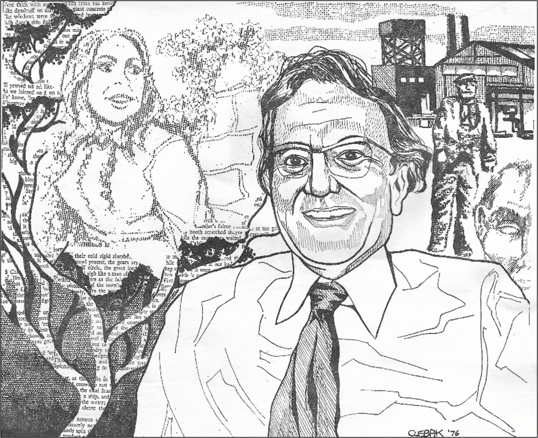
More details of Jim Jones’ life can be found in both the presentation and the transcript below as well in an earlier blog post. The presentation contains both the audio of the poems being read, as well as background slides with illustrative material. The transcript itself contains only one picture, which is of particular relevance to one of the poems.
For those interested in reding more of Jim Jones’ poetry, pdfs of two publications from the 1970s, and a compilation of his Blackcountryman poems can be purchased from the Black Country Society online shop.
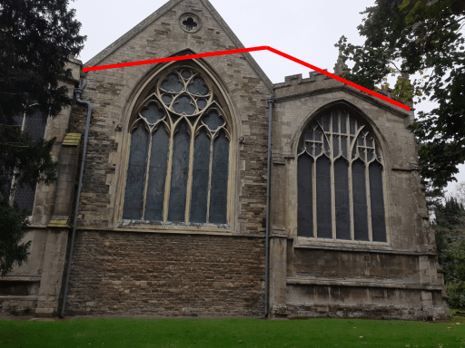
Three recent blog posts here, here and here, contain transcripts of newspaper reports that describe the restoration of All Saints Church in Oakham in 1858, under the direction of Gilbert Scott. It is clear from these reports that at the time the church was in a very bad state of repair and most of the restoration was concerned with repairing defects, particularly to the roofs, renovating historical features and replacing much of the internal furnishings. However there was one major area of the church where significant work was carried out that went far beyond simple repairs – to the chancel and to the east end in general. In his condition assessment Scott (1) wrote
The chancel has a roof of modern date concealed by a flat plaster ceiling which cuts across the chancel arch. The same roof extends over the north chancel aisle, thus deforming the east end, by placing two divisions under one gable. The north aisle has most beautiful oak panelled ceiling, which happily conceals its roof from within. The south aisle of the chancel has modern roof, of the very meanest description, so that in the interior of the chancel and its aisles we have first a plain flat plaster ceiling to the chancel itself; then to the north aisle a beautiful oak ceiling, showing the manner in which the ancient builders treated their work; and on the south aisle the roof of modern hedge-carpenter, such as would disgrace a cart-shed.
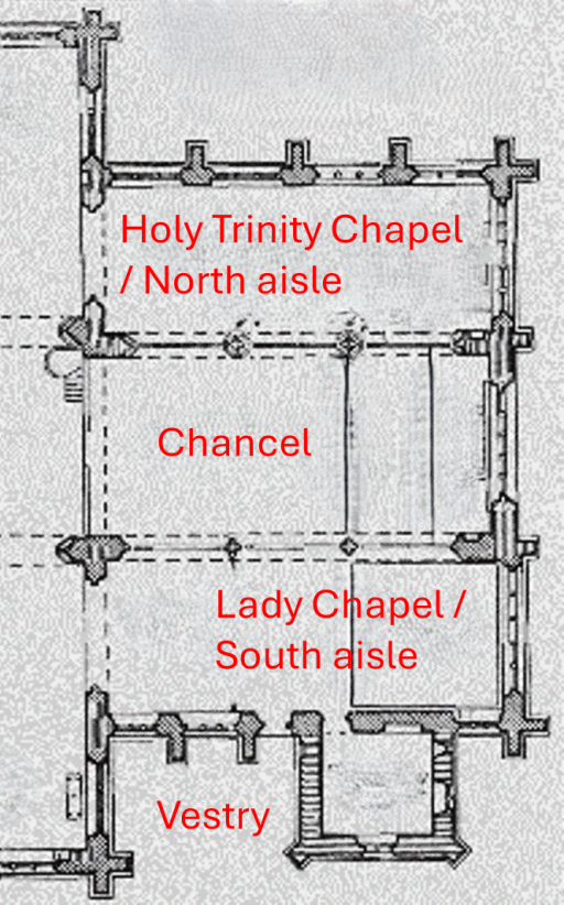
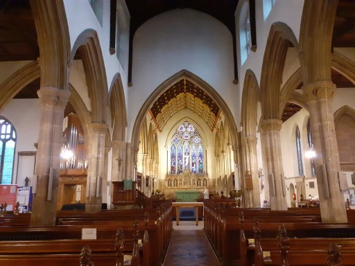
It is not altogether clear what is being described here, particularly in the first sentence, and this is the aspect of the work that will be considered in this post. First of all, let us consider the current (2024) state of that area of the church. A plan is given in figure 1 and shows the chancel, with the 13th century Holy Trinity chapel to the north and the Lady Chapel (built around 1480) to the south (the chapels are the north and south aisles referred to in the above quotation) (2). Figure 2a,b,c,d shows views of chancel and the chapels from the west end of the church. The chancel arch, referred to by Scott can be seen in figure 2d. It can be seen that the chancel itself is higher than the chapels to either side and certainly higher than the chancel arch, so the ceiling that Scott took exception to has been removed.
Figure 1. Plan of the east end of the church
a
b
c
d
Figure 2. a – North aisle / Holy Trinity chapel; b -Chancel; c – South aisle / Lady chapel; d – view from nave showing chancel arch.
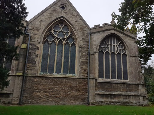
Photographs of the east end of the church from the outside are shown in figure 3. There is no natural viewing point to take an overall photograph and the view is obstructed by trees in the churchyard, but, despite the odd perspective, both chapels and the chancel can be seen. The change in stonework around and above the chancel window shows the rebuilding of the 1850s.
a. Lady chapel and chancel
Chancel and Holy Trinity chapel
Figure 3. The east end of the church
Happily we can gain an understanding of what this end of the church looked like before the restoration from an 1851 model kept in the church (3). This is in a glass display case, currently in the north transept, and was not altogether easy to photograph, largely because this entailed standing on a pew, turning through ninety degrees and trying to photograph something in a glass case next to a window, with multiple reflections. Nonetheless, a rather poor quality photograph is shown in figure 4. The caption on the display case reads
In loving memory of Mary Grinter who passed to her rest on 10th February 1950. Age 87 years. This model was made by her father John Pitt Coulam (1833-1898)
Figure 4. The 1851 model
Figure 5. Photograph of the east end of the church showing the roof line of the 1851 model.
The east end in this photograph can be seen to be very different from the photographs of figure 3. Figure 5 shows the 1851 roof line from figure 4 superimposed on the photograph of figure 3b. And from this one can understand what Scott meant. The chancel seems to have been reduced from its original height (which the height of the chance arch suggest was similar to today), and a pitched roof added over both the north aisle / Holy Trinity, chapel and the chancel itself. Thus, the two chapels indeed share a gable, and the roof / ceiling of the chancel would cut across the chancel arch in a very un-elegant fashion. The window at the east end would also seem to have been deliberately lowered to fit into the new arrangement. Figure 6 shows, in an edited version of figure 2b, how Scott would have seen the interior of the church, with the top of the chancel arch blocked, a lower flat ceiling in place, and a smaller east window
Figure 6. The chancel as would have been seen by Scott, with chancel arch blocked, lowered flat ceilingand smaller east window
Scott’s work changed all this, restoring the chancel to its original height and adding sound roofs and spectacular internal ceilings. A new east window was inserted, which, the 2003 church guide (3) tells us, was criticised at the time for being of “decorated” rather than “perpendicular” form. Funny what folk get upset about.
So why on earth did this happen – why was the original rather elegant design of the chancel and chapel changed in this way, presumably sometime in the 15th to 17th centuries. I can think of two possible reasons. The first is wholly utilitarian – the chancel, and in particular the roof, may have been in a very poor state of repair, and required extensive renovation and repair. The arrangement criticised by Scott could have been a cheap way of making that end of the church reasonably sound, if rather ugly. The second reason has a more theological basis. After the Reformation, the Elizabethan settlement enforced conformity of practice – in particular taking down the altars at the eats ends of chancels and replacing them, for the purpose of celebrating holy communion, with a table placed lengthways in the chancel, around which communicants would have gathered, with the celebrant on the north (long) side of the table. The combined chancel and north chapel would thus have provided a typical Elizabethan “communion room”. A surviving example of such an arrangement can be seen locally at Brooke. (figure 7) where the spacious chancel is separated from a north chapel by a simple screen. This arrangement was only temporary and after the restoration of the monarchy in 1660, with the Laudians in the ascendency, the altars at the east ends of chancels were reinstated with little opposition. Some clergy however continued to celebrate from the north end even with the altar in the new positions, and indeed, this is still the case in a few places.
Whatever the reason, I have to admit (albeit grudgingly) that Scott was correct in this case in his desire to restore the chancel to its gothic glory from what seems to have been a somewhat botched Elizabethan / Stuart arrangement.
One further point arises. In the north aisle / Holy Trinity chapel there is a large chest tomb, with no dedication, placed lengthways next to the chancel (figure 8). It is said in (2) to be early 16th century – perhaps around the time of the Reformation. The images of sheep bells or wool weights on the side have led to the suggestion that it might be the tomb of a wool merchant. In the chancel arrangement before Scott’s restoration this would have been very prominent – indeed in the centre of the gable, possibly between two altar positions. One can speculate that the tomb was either placed in this position deliberately or indeed whoever was responsible might also have rebuilt the chancel / chapel to give the tomb such a prominence.
‘Parishes: Oakham’, in A History of the County of Rutland: Volume 2, ed. William Page (London, 1935), British History Online [accessed 21 October 2024].
Aston N (2003) All Saints Oakham, Rutland. A guide and history.
“Communion of the Saints” in a Baptistry in Padua (José Luiz)
On October 31st 2024, I gave a lecture at All Saints church entitled “A time to mourn, and a time to dance – the All Saints season through the ages“, which explored how the season between Halloween had developed over the centuries and millennia. This was part of a wider celebration of the festival of All Saints that included a musical concert; church tours; a tower climb, a pop up cafe and a number of services of worship.
In the church notices for the Sunday beforehand I wrote the following introduction to the talk.
The start of November marks the beginning of winter in seasonal terms, and is the time of a number of festivals and celebrations – Halloween, All Saints Day, All Souls Day, Bonfire Night and Remembrance Day. In this talk I will explore how all these evolved through the ages from pre-Christian times, through the medieval period to the Reformation and from then to the 21st century. A few other festivals which haven’t made it to modern times will also be mentioned. There will be a large cast of popes and bishops, kings and queens, saints and sinners with a few fairies and witches thrown in. I will of course be using PowerPoint, the academics comfort blanket, with some audio tracks, so if nothing else the almost inevitable failure of technology may be entertaining. But I found putting the talk together really quite interesting, and I l learnt a few things that were new to me on the way, so hopefully others will find it interesting too – and possibly even enjoyable!
This web page contains links to a transcript of the talk, and a re-recording of the talk made after the event. The latter contains the PowerPoint slides I used; the former is just the text. The presentation does not include the audio clips I used in the talk – YouTube would not have allowed me to upload these for copyright reasons.
For those interested in reading further about the development of seasonal celebrations in England I would recommend the following book by Prof Ronald Hutton – from which I took much of the information for the talk.