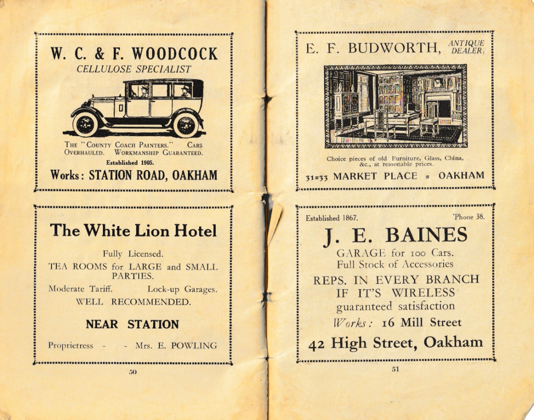
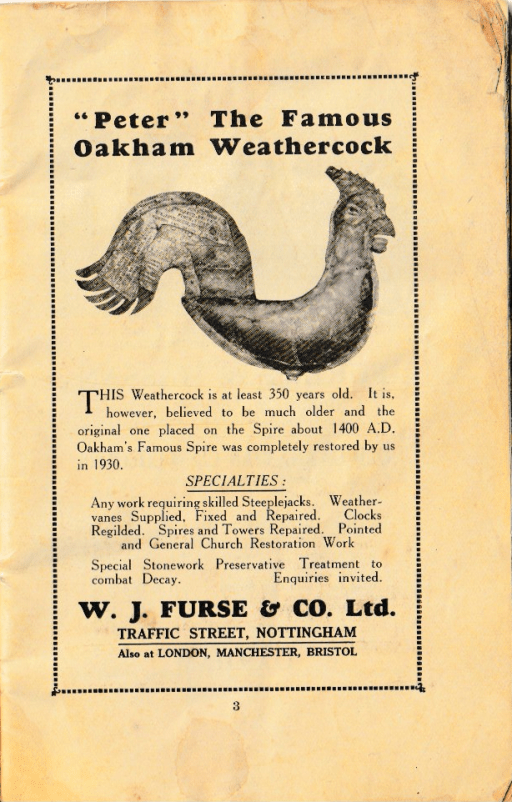
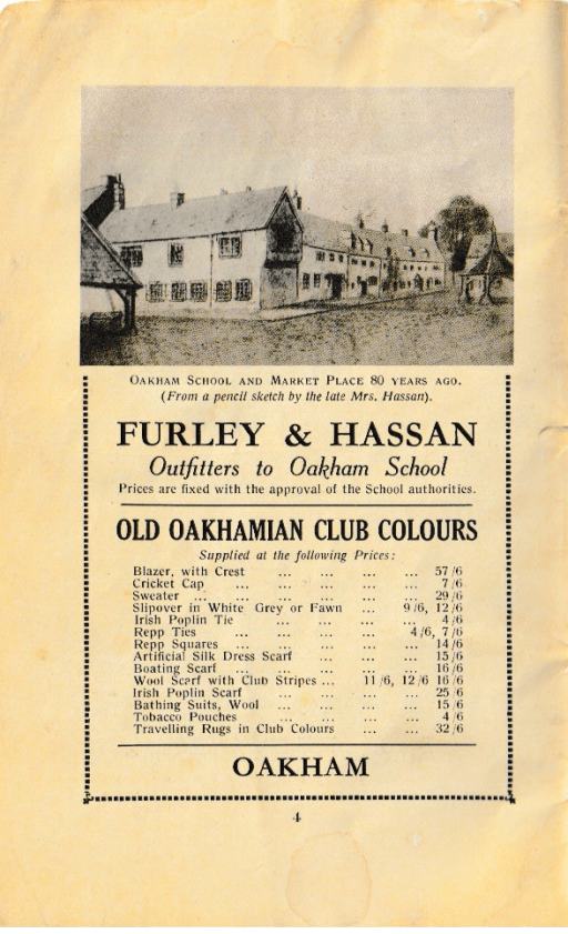
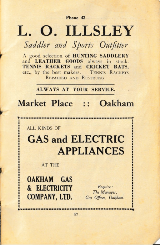
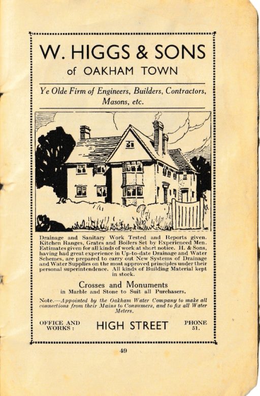
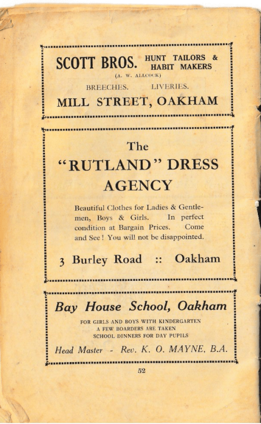
Recently I have come across a number of old Church Guides and Histories for All Saints Church in Oakham- from 1932, 1972 and 1980. PDFS of these can be found on the History and Heritage page of the church website. There comes a time of course when old guides and histories become historical documents in their own right, revealing how the church was thought of and communicated at the time of writing, and in their description of their contemporary activities, give an indication of the nature of the church’s worship and other activities. This is particularly true of the 1932 guide – The Story of Oakham Church, School and Castle by the then vicar, A. Edward Fraser. In what follows I post just a few pages from this this guide – the adverts it contained for local businesses that paid for its publication. These are given below, and I suspect that Oakham readers will find them of considerable interest.
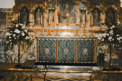
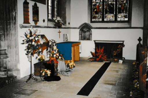
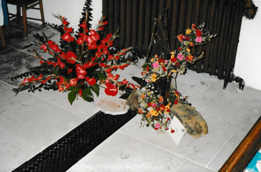
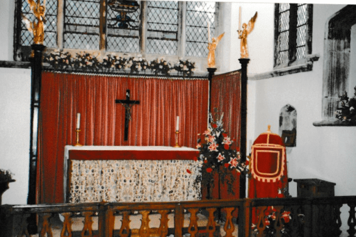
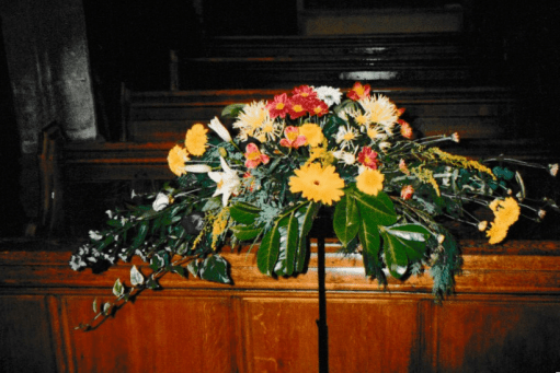
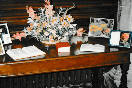
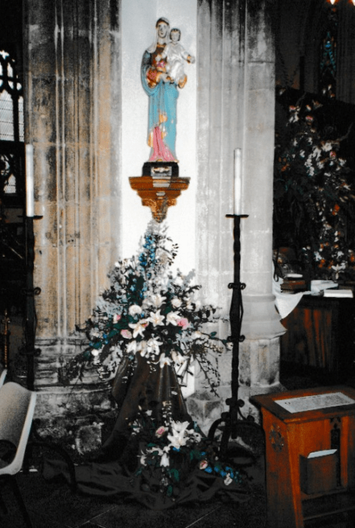
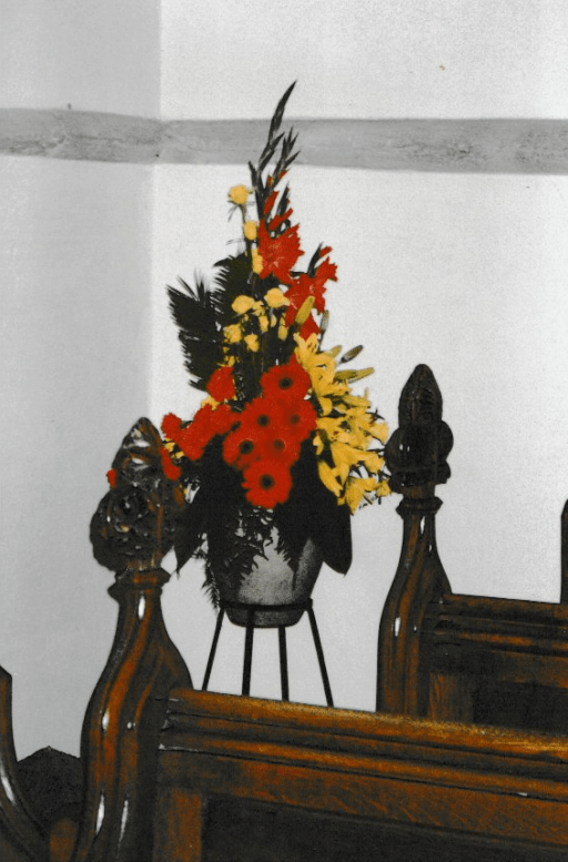
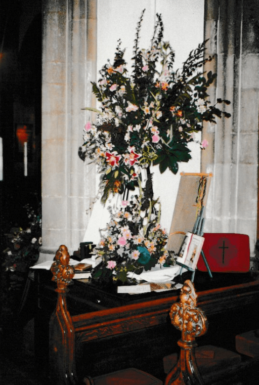
In 1996, All Saints church in Oakham, organised a flower festival. Some photographs from this event were deposited in the church safe for safe keeping, and I have recently come across these whilst searching the safe for other items. It seems to me that these photos are well worth sharing – both for the flower displays but also for the glimpse they give of the church from 30 years ago. Pleas click on the photos below for larger versions of the pictures. The colours aren’t marvellous – they can only be as good as the prints – but they will be of interest to some.
Holy Trinity ChapelHoly Trinity ChapelNorth TranseptHigh altarSouth TranseptSouth TranseptSouth TranseptLady ChapelLady ChapelArea near north doorCentral CrossingCEntral CrossingNorth TranseptNear pulpitEntrance to Lady ChapelWest End
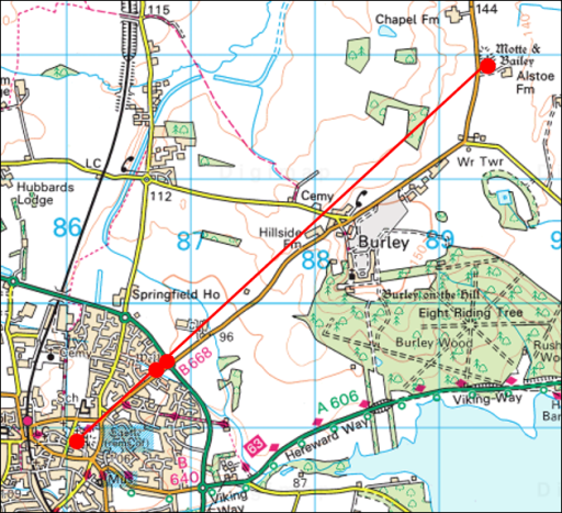
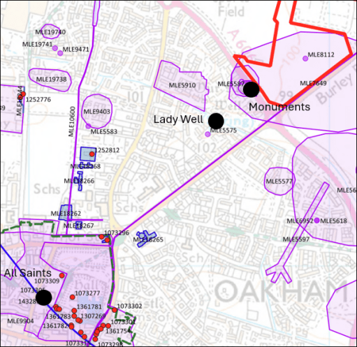
In a post “A possible Anglo-Saxon church group at Oakham in Rutland” from May 2024, I noted that All Saints Church in Oakham, and Our Lady’s Well to the north east were on what could be a mid-summer sunrise / mid-winter sunset solar alignment. I went no further than simply noting this, and didn’t speculate further about what it might imply. One always needs to be cautious about such alignments – they can be simple coincidences, and, if they are being looked for, can be found in the most unlikely places. For example from Borrowcop Hill in Lichfield, possibly an ancient burial mound, there was until recently a perfect alignment with the medieval spires of Lichfield Cathedral and the cooling towers of Rugeley power station, the latter sadly now demolished, which can hardly be of ancient origin. That being said, a reader of the May 2024 post sent me some further information that suggests that a cluster of Stone Age / Bronze Age / Iron Age remains have been found to the north east of Our Lady’s well that could also be on the same alignment. Looking at this further, I realised that several kilometres to the north east of that, and again on much the same alignment, we have Alstoe Mount, another historic monument. These are all shown on the Ordnance Survey map extract of Figure 1 below. The nature of this possible alignment, along the axis of the mid-summer sunrise and mid-winter sunset is discussed further in this post.
Figure 1. The possible alignment. The sites are shown as red circles – from the south west to the north east these are All Saints church in Oakham, Our Lady’s Well, the historic monuments and Alstoe Mount.
The sites
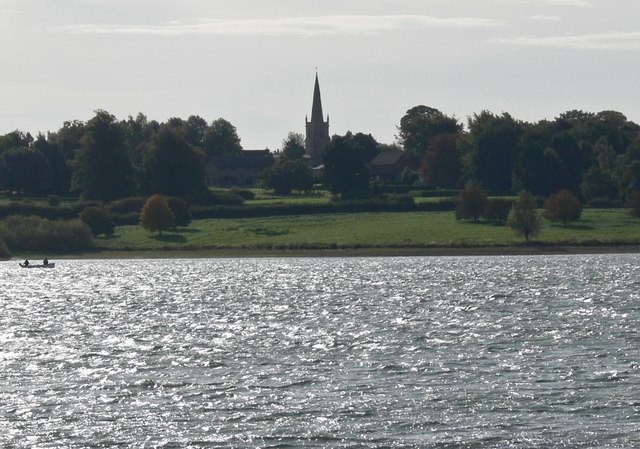
All Saints church, Oakham
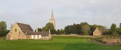
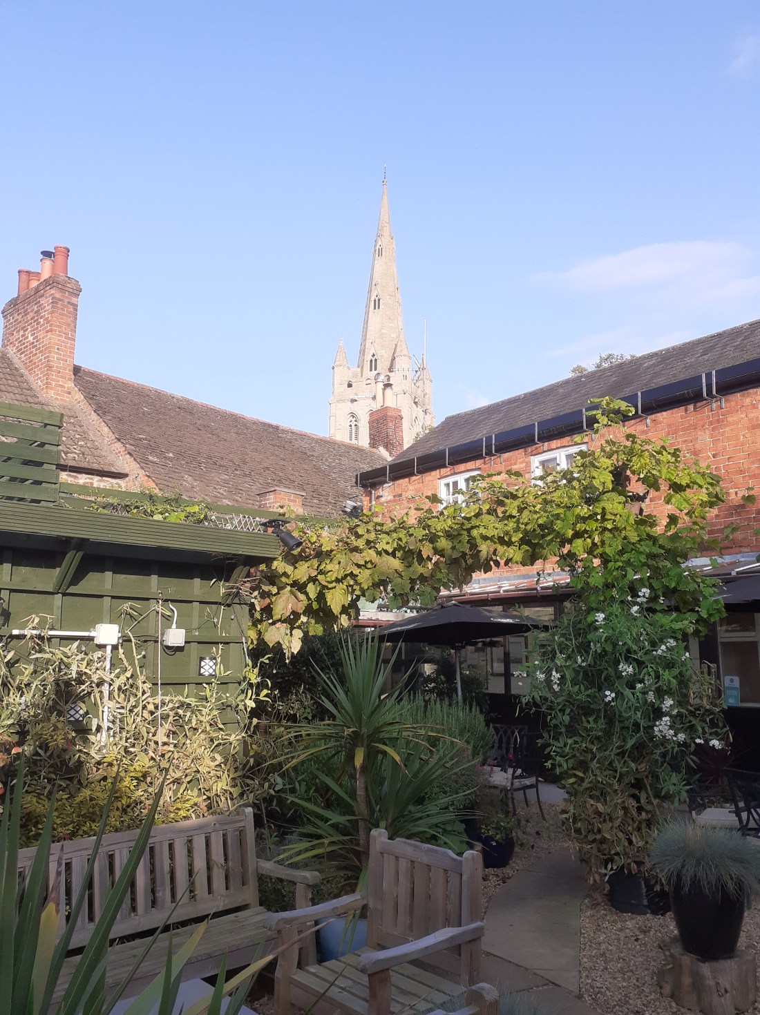
All Saints Church is Oakham (Figure 2) is a twelfth century church with thirteenth to fifteenth century additions. Internally it is pure Victorian, having been restored by Gilbert Scott. However it almost certainly stands on the site of an Anglo-Saxon church, and a church in Oakham is mentioned in the Domesday book. A compendium of historical information is given on the church website.
Figure 2. All Saints Oakham and Oakham Castle (photograph by the author)
Our Lady’s Well
Our Lady’s Well is a historically well-attested pilgrim site to the north east of All Saints church – see Figure 3. To quote from Leicestershire and Rutland’s Holy Wells by Bob Trubshaw from 2004;
Our Lady’s Well was once famed for curing sore eyes – providing that a pin was thrown in first. In 1291 indulgences could be obtained by visiting Oakham Church during its patronal festival and, for a price, joining a pilgrimage to Our Lady’s Well. In 1881 it was visited by the future Queen Alexandra. The well is to the north-east of the town, in a somewhat overgrown area between the Cottesmore road and a modern housing estate (NGR SK:866095).
It’s current condition is no better, and it is now impossible to access the well, in an overgrown plot of wasteland, which seems a shame.
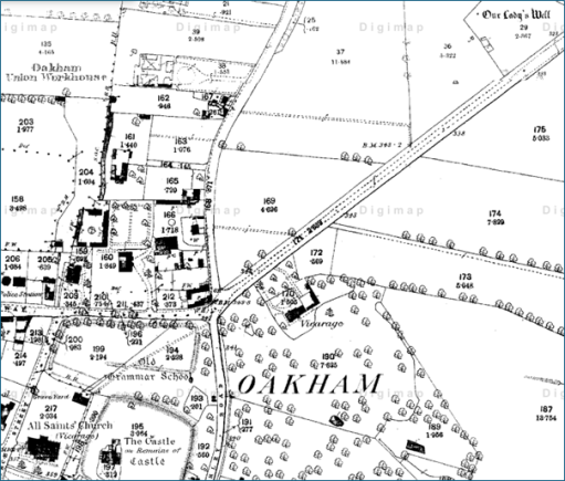
Figure 3. Location of Our Lady’s Well from the 1880 Ordnance survey Map (All Saints church is at the bottom left, and the well at the top right.)
The Stone Age / Bronze Age / Iron Age monuments
The material I was sent concerning the Stone Age / Bronze Age / Iron Age monuments came from “Land off Burley Road Oakham, Vision and Delivery Document” produced by Pigeon Investment Management with regard to a proposed hosing development. Figure 4 is taken from that document and shows the location of Our Lady’s Well and the relevant monuments.
The monuments are listed as follows, where the numbers are those on the Historic England National Heritage list.
MLE5587 – Possible Mesolithic site west of Burley Road MLE5592 – Late Iron Age/Roman site west of Burley Road MLE5593 – Bronze Age burial, west of Burley Road MLE5594 – Neolithic pit circle site west of Burley Road
Alstoe Mount
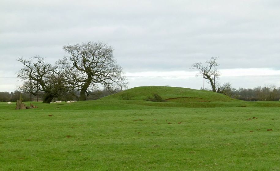
The substantial mound of Alstoe Mount (Figure 5) is described on the Ordnance Survey map as a Motte and Bailey. That is almost certainly not true. It was probably the Moot location for Alstoe Hundred. Details of the mound and the surrounding deserted village are given in the Historic England list entry.
Figure 5. Alstoe Mount (photograph from Historic England by Alan Murray-Rust, 2016)
The possible solar alignment
A current mid-summer sunrise / midwinter sunset direction from Oakham is 47.5 degrees east of north (from SunCalc). However obtaining a precise value to compare with the possible alignment shown in Figure 1 is difficult for two reasons. Firstly the actual direction of sunrise and sunset has varied over the millennia – and as things stand, we have no date for which a calculation can be made. This change is however small – of the order of 0.2 to 0.5 degrees. Also the apparent direction from any point depends upon the precise topography of the horizon over which the sunrise / sunset is observed – and as we know nothing about the observation point or the direction of observation, this is again not possible to specify. This again results in an uncertainty of around 0.5 degrees. So all we can probably say is that we are looking for an alignment of 47.5 +/-1.0 degrees east of north.
The actual directions between All Saints Oakham and the other sites is as follows.
Oakham to Our Lady’s Well – 46.3 degrees Oakham to Stone Age / Bronze Age / Iron Age monuments – 47.1 degrees Oakham to Alstoe Mount – 47.8 degrees
Again there is uncertainty here – particularly in the specification of the precise site at Our Lady’s Well of any structure that might have been visible from All Saints, and similarly the precise position of any relevant structure in the monument field. The location point for All Saints (taken as the centre of the building) could be around 10m to the east or west. This can have an effect of the bearings of Our Lady’s Well and the monuments by around 0.25 degrees. Considering these uncertainties the above bearings and a sunrise / sunset direction of 47.5 degrees seem broadly consistent, and thus there does seem to be some evidence for all four sites lying along a solar alignment of some significance.
But there is another issue – that of elevation. A cross section along the proposed alignment is shown in Figure 6. From this it is clear that Alstoe Mount would not be visible from Our Lady’s Well or from the Monument field, and would only just be visible from All Saints if any observation platforms that existed there and at Alstoe were raised off the ground by a metre or so. Beacons however would have been visible.
Figure 6. Section through the proposed alignment (from Google Earth Pro.).
Discussion
So what does the above analysis lead to. Firstly I think there is plausible (but far from conclusive) evidence for a mid-summer sunrise / mid-winter sunset alignment, at least between the Monument field / Our Lady’s Well and All Saints, and possibly between Alstoe Mount and All Saints. but the available evidence gives us no chronological information as to when the alignment might have been of significance. Our Lady’s Well is first mentioned in the late Middle Ages and All Saints and Alstoe Mount can only be said to become of important in the pre-conquest period. There is no evidence at all, except in the monument field, for the other sites being important in the Stone Age / Bronze Age / Iron Age. So in my view it is probably better to stop at this point – acknowledging that there may be a solar alignment, but not taking speculation any further. The boring, cautious approach I guess, but I don’t think there is much more to be said.
Some summer reading and viewing – a compilation of some of my recent blog posts and a presentation on the history and heritage of All Saints church in Oakham.
Blog posts
The memorials of All Saints Oakham. Photographs and brief descriptions of the wall mounted memorials at All Saints church in Oakham (May 19th 2025)
From Oakham to Mandalay. The story of a young curate from Oakham and his brief service as a missionary in Burma before his early death (April 29th 2025)
Kinetic Water Power – some odd words on a memorial in All Saints Oakham led to some interesting findings about how church organs were powered at the start of the 20th century (25th April 2025)
The 1858 Restoration of All Saints church in Oakham. Part 1, Part 2,Part 3 Three linked posts giving the transcripts of press reports of the restoration and re-opening of All Saints church in 1858, including the condition report by Gilbert Scott (October 9th 2024)
A time to mourn and a time to dance. A time to mourn and a time to dance – the All Saints season through the ages. The video of a talk given at All Saints Oakham on October 31st 2024
For some summer reading – a compilation of some of my recent blog posts on ancient and more modern Oakham and Rutland history.
The street topography of early Oakham. A post that considers how the street of Oakham and the surrounding areas might have been configured in the Anglo-Saxon and Norman periods (December 8th 2024)
Oakham roofs. A photo blog simply showing the upper floors and roofs of the buildings on the north side of the High Street in Oakham. For no other reason than I like roofs. The history is implicit rather than explicit (July 23rd 2024)
Rutland – an enigmatic history – a further speculative consideration of three oddities about the early history of Rutland (2nd February 2024)
Rutland and the Hwicce Some further thoughts on the County of Rutland and its association with the Hwiccan tribe of Worcestershire and Gloucestershire (30th December 2023)
The Origin of Rutland – some speculations on the early history of the area where I now live (2nd December 2023)
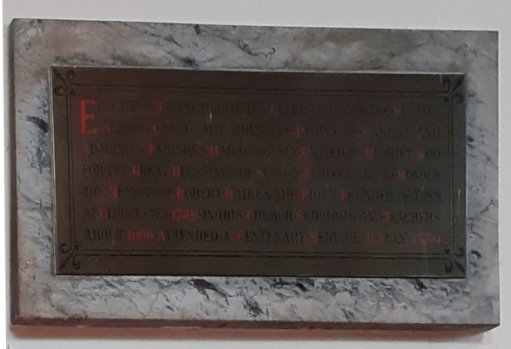
All Saints church in Oakham is not particularly well endowed with memorials to individuals and events, and there are no spectacular carvings. However some of those that do exist enable interesting stories to be told. In this post I present a number of these, with links to more information, and highlight those memorials that require further investigation. The post is very much a work in progress, and I will edit it as more information becomes available.
Note – to read some of the inscriptions below readers may well need to magnify them. Even then, some will take a little patience to read, particularly the brasses where it is difficult to take photographs without reflections obscuring the text.
Vestry
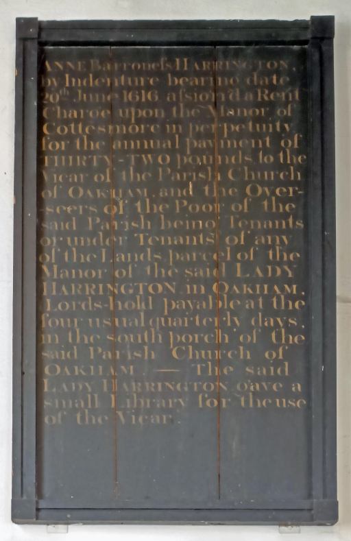
I have discussed the wooden memorial of the Lady Harrington bequest – money for the relief of the poor and a donation of a Parish Library – in two blog posts here and here. The memorial is in the vestry on the south side of the church and is not usually publicly accessible.
Chancel
A transcript of this plaque in the Chancel is given in the post From Oakham to Mandalay and a little more information is given on the career of Henry Jerwood.
Lady Chapel
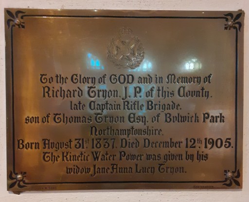
A transcript of this plaque in the Lady Chapel is given in the post Kinetic Water Power, and information is given there about Richard Tryon and (at some length) the Kinematic Water Power apparatus.
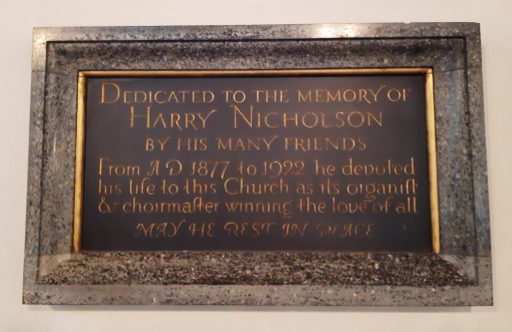
The life and times of long term organist of All Saints church and the founder of the Oakham Choral Society are well described in a blog from the Rutland County Museum.
Pulpit
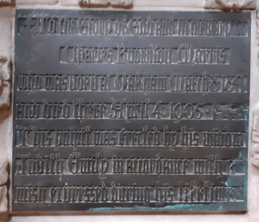
The pulpit has a dedicatory plaque, very low down near the foot of the steps. It reads as follows To the Glory of god and in remembrance of Charles Knowlton Morris, who was born in Oakham March 18 1841 and died there April 4 1905. This pulpit was erected by his widow Judith Emily in accordance with his wish expressed during his lifetime. Charles Morris was a brewer and a coal merchant. A window in the church has a similar dedication from his wife and is described in the following way Depicting Endurance, Humility, Innocence, Love, Principle, Sympathy, Fortitude, Charity and Justice, as mostly portrayed by scenes from Jesus’ life. The badge of the Vale of Catmose lodge of the Independent Order of Oddfellows is at the bottom.
South Transept
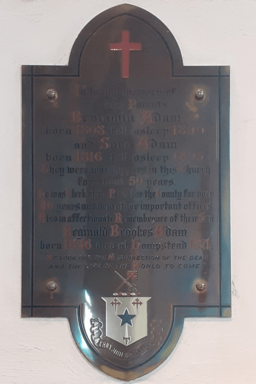
This difficult to read memorial is to Benjamin Adam (1808-1890?), his wife Sara (1816-1895?) and their son Reginald Brookes Adam (1846-1871?). We are told that Benjamin and Sara were worshippers at All Saints for over 50 years, and that Benjamin was Clerk of the Peace for the County (a legal officer) for over 40, and that he also held other important positions.
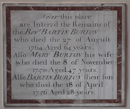
The Church of England Clergy database reveals that Bartin Burton was born in Oakham and served as Curate in the parish of Rockingham, Rector at Oxendon (both in Peterborough diocese) from 1728 to 1729 and Vicar of Ravenstone in Buckinghamshire (Lincoln diocese) from 1747 to 1764.
North Transept
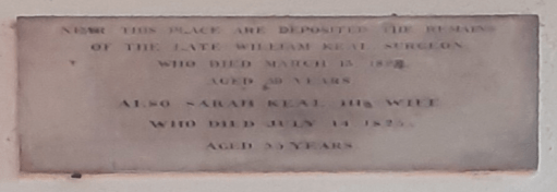
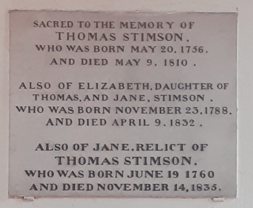
These four memorials in the north transept are placed one above the other in the order shown to the left. The top one commemorates William Keal, a surgeon (d1824?) and his wife Sara (d1825). The one below it commemorates the lives of Thomas Stimson (1756-1810), his wife (relict) Jane (1760-1835) and their daughter Elizabeth (1788-1832).
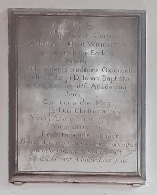
The third is in Latin and commemorates John Abraham Wright (d1690) aged 79, vicar for 30 years, during and after the Commonwealth period. In the first instance he served only one year (1644-5) before he was and replaced by the parliamentary favourite Benjamin King. He took up his post again after the Restoration in 1660.
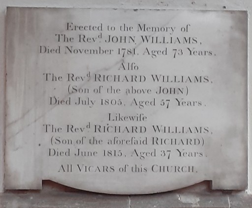
The lower memorial is to three generations of Vicars of the parish – John Williams (d1781), Richard Williams (d1805) and Richard Williams (d1815). More details of their appointments at Oakham and elsewhere can be found in the Church of England Clergy Database.
South Aisle
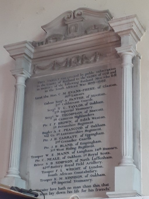
This Boer War monument is now above the choir vestry in the South aisle and not easily accessible – or indeed to photograph. The expertise of a military historian is probably required to unpack and present the stories of those listed here.
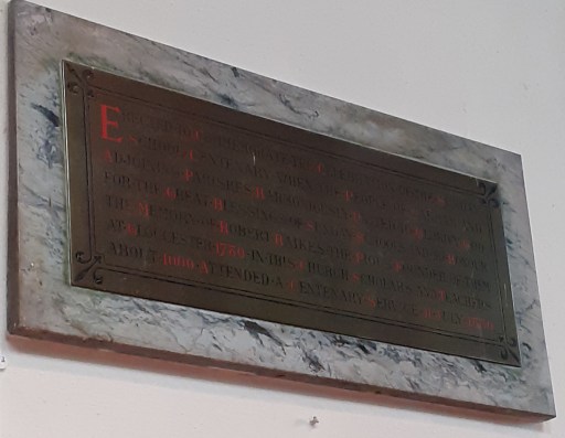
The monument above was both difficult to photograph (to avoid reflections) and difficult to read. It is shown in two forms – as originally taken, and with an attempt made to remove the effect of perspective. It commemorates the 100th anniversary celebration of the Sunday School movement, which around 1000 people attended, and commemorates its founder, Robert Raikes of Gloucester.
North aisle
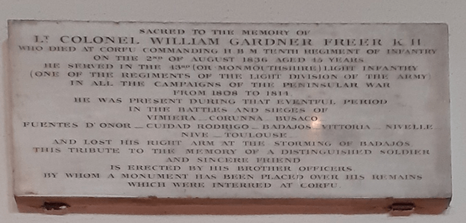
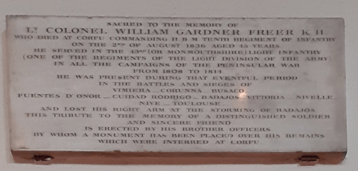
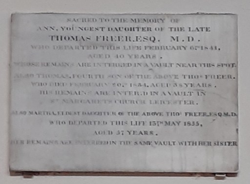
These three monuments are placed above each other in the north aisle in the order shown. The top one is too small to read easily from ground level. They all refer to the Freer family from the early 19th century. The bottom memorial is to Thomas Freer, a doctor, who died in 1835, his wife Martha who died in 1827, and his third son, Edward Gardner who fell in action in the Pyrennees in 1813 aged 20. The second memorial commemorates Thomas and Matha’s youngest daughter Ann (d 1844), their fourth son Thomas (d 1834) and buried in Leicester, and their eldest daughter Martha (d 1835). Finally the upper memorial describes in very small text, Lt. Colonel William Garner Freer who died in Corfu in 1836, whilst commanding the 10th Infantry Regiment. His long military career is outlined, including the loss of his right arm at the storming of Badajos. He is buried in Corfu.
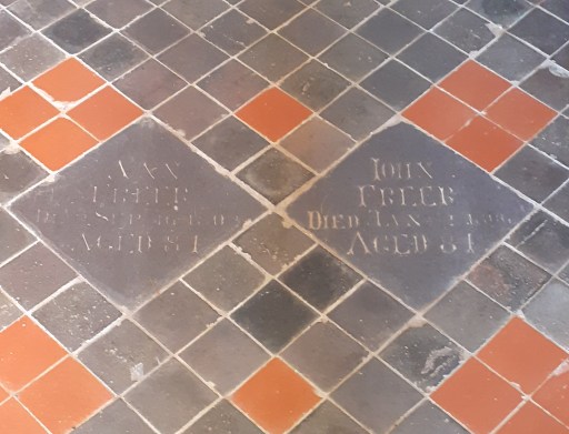
The Freer’s are also commemorated in two tiles in the nave aisle – much faded as they are on the main thoroughfare through church. They are dedicated to Ann and John who, as far as I can make out, died in the early 1800s.
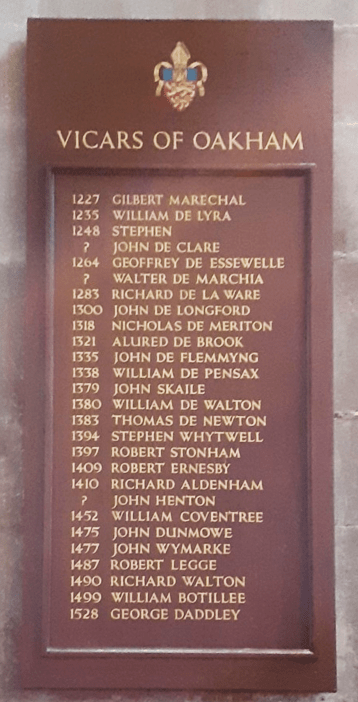
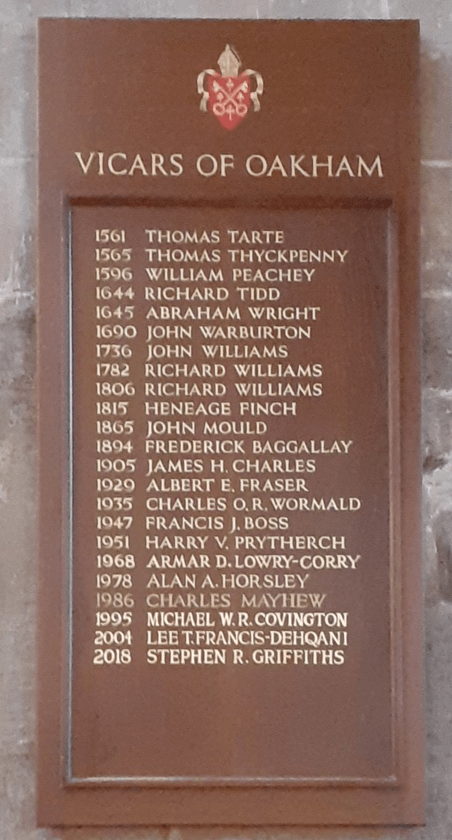
West End
More details of the Vicars of Oakham can be found in the church guide. The Church of England Clergy Database also includes records for both vicars and curates of the parish, and of the surrounding chapels from the mid-sixteenth to the early nineteenth centuries.
In this post we will consider how bus and train transport in Oakham has changed from the 1960s to the present day, for both good and bad. To do so, we will use a variety of historical resources, primarily old bus and rail timetables. We will look at four time slices – at the state of the railways in the early 1960s i.e. before the Beeching cuts; at the bus services and train service provided in the late 1960s, after Beeching but before bus deregulation; in the late 1990s after rail privatization and bus deregulation; and the current situation. The time slices chosen have in effect been determined by what information is available. However, between them they give a clear picture of how bus and train services in Oakham have developed (or perhaps degraded) over the last 50 to 60 years.
Sources and limitations
For the early 1960 rail services we use the following sources:
London Midland Region timetable for 1963 and 1965 (personal collection);
These are quite comprehensive and give a full coverage of the rail services at that time, which is of course before the Beeching Report and associated closures. The sources for the late 1960s are both taken from Timetable World:
London Midland Region timetable for 1969;
Bus timetables for the late 1960s.
Whilst the rail timetables can again be expected to be comprehensive, the bus timetables are probably less so. Finding services through Oakham requires a search of the index for bus companies operating in the area. It is possible that I have missed some potential sources of information, although I believe I have captured most of the main services. What I have almost certainly missed are any very local services operated by small operators in the Oakham district, which simply do not appear on the Timetable World web site. The bus timetables are from the years 19868 and 1969 with one exception from 1973 (for a Saturday only service). For the late 1990s we obtain information from the following sources:
Railtrack Great Britain timetable for 1999 (from Timetable World);
Great Britain Bus Timetable 1999 (personal collection).
The Great British Bus Timetable is a compilation of services from across Great Britain. It admits that it excludes local operators and services of a purely local nature, so again the bus information might not be fully comprehensive here. For the current situation we used information for bus and train times that is available on the web as follows:
In the analysis that follows, we will identify bus and train operators by a two letter code.
BL – Blands of Cottesmore – a local bus company based in a village to the east of Oakham.
BA – Bartons or Barton Tobin Hood – a large regional bus company based around Nottingham, but with a garage in Stamford.
BR – British Rail – the National pre-privatisation rail operator.
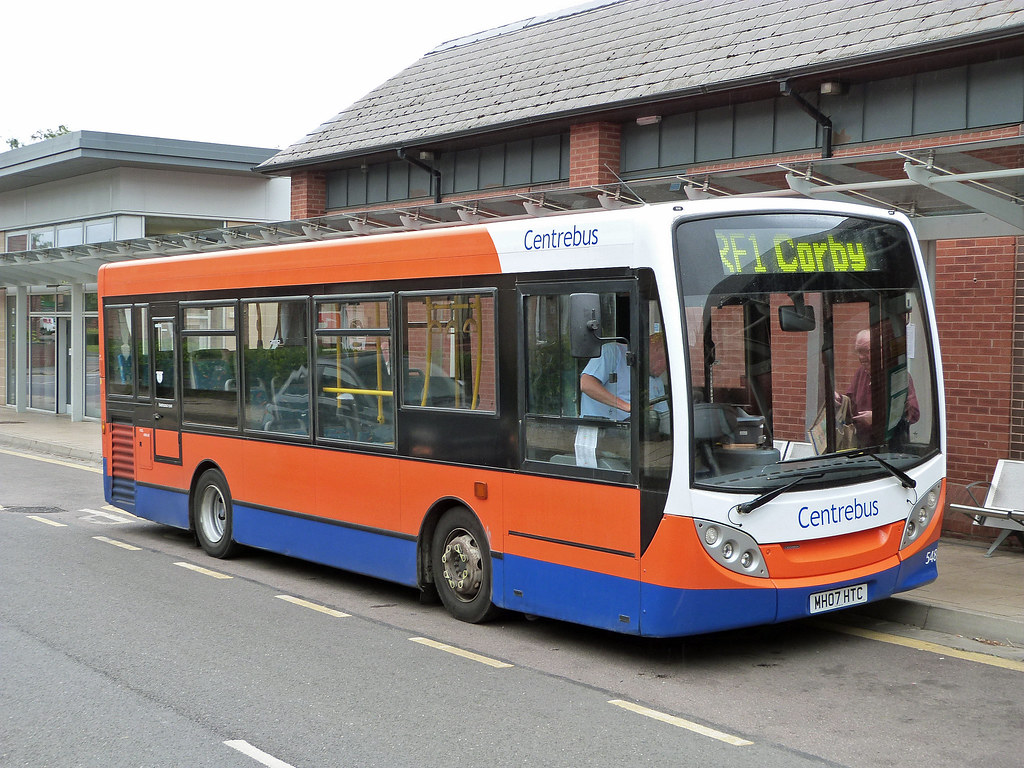
CB – CentreBus – an East Midlands regional operator.
CC – Cross Country Trains – the current franchise operator of trains through Oakham, with a wide nationwide network.
CT – Central Trains – a previous operator of trains through Oakham, based in Birmingham with a wide regional network across the Midlands.
EM – East Midlands Railway – the mainline train operator serving the East Midlands cities, that runs occasional services through Oakham (and is, bizarrely, the firm responsible for running the station).
KI – Kinchbus – a small Loughborough based bus company
LR – Lincolnshire Road Car – a large regional company in the 1960s, primarily based, as might be expected, in Lincolnshire.
MR – Midland Red Leicester – the regional operator of the very large Midland Red network that operated buses across the wider Midlands area.
RC – Rutland County Council – which currently operates a small number of services for which no franchise partner could be found.
UC – United Counties Omnibus Company – a large regional company primarily based in the Northampton area.
Analysis
In what follows we consider the public transport services through time in four categories:
Local interurban services to Stamford, Melton Mowbray and Uppingham;
Regional services to Peterborough, Leicester, Nottingham, Grantham and Corby;
Long distance services to Birmingham, Cambridge and London;
Miscellaneous services for which information is incomplete – very local services, long distance coaches etc.
For the first three categories we present the data in tabular form in a consistent format, and then discuss how these have evolved over time. Discussion of the latter category is inevitably rather more diffuse due to the lack of much historical information.
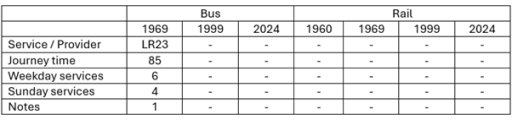
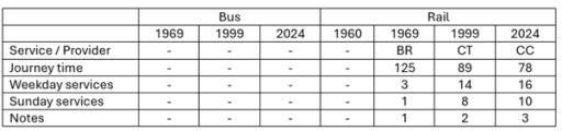
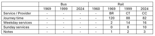
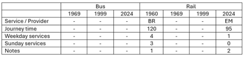
Local interurban services
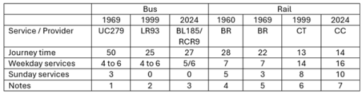
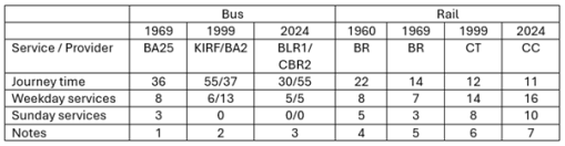
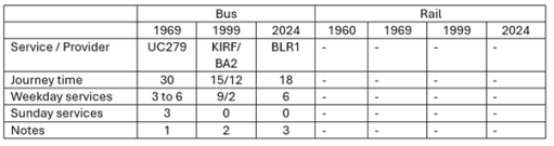
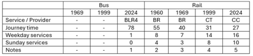
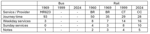
Tables 1 to 3 show, in standard form, the bus and train services between Oakham and Stamford, Melton Mowbray and Uppingham. Journey times and number of journeys / day are shown. Clearly there are both train and bus options to Stamford and Melton Mowbray, but only bus options to Uppingham. The bus journeys in 1969 and 1999 were provided by major bus operators for which Oakham was at the edge of their operating area – United Counties in Northampton, Lincolnshire road Car, Bartons in Nottingham, Kinchbus in Loughborough. Currently they are provided by more local operators – primarily Blands, but with Rutland County Council running the current Oakham to Stamford service. The bus journey times and service frequencies have remained similar over the period (although note that the former can vary significantly depending on what villages are served on the way between urban centres. The loss of Sunday services is obvious from the data in the tables. What is not so obvious is the fact that evening services on all the bus routes have been significantly cut over the study period.
By contracts the train services have seen major improvement. The Leicester to Peterborough shuttles stopped at all the village stations before Beeching and the journey times between Oakham and Melton Mowbray and Stamford were of the order of 20 minutes. By 1969 these stations had closed and the journey times significantly reduced. This reduction has continued up to the present with faster stock being introduced on the line and, most significantly, the number of journeys has increased by a factor of two with the introduction of hourly through Birmingham to Cambridge / Stansted Airport services. These improvements have however resulted in a significant loss of connectivity to the villages where stations were closed in the 1960s.
Table 1. Oakham to Stamford
Uppingham to Stamford via Ridlington, Wing, Oakham (Railway Station Crossing), Exton, Whitwell, Empingham and Great Casterton. UC also operated service 280 with one return journey on Fridays only from Oakham to Stamford vis Edith Weston.
Oakham to Stamford via Whitwell, Empingham and Great Casterton.
Oakham to Stamford via Whitwell, Empingham and Great Casterton. BL185 has one service from Monday to Friday and four on Saturday. RCR9 has five services Monday to Friday.
Leicester to Peterborough East via Syston, Frisby, Melton Mowbray, Saxby, Ashwell, Oakham, Manton for Uppingham, Luffenham, Ketton and Collyweston, Stamford, Helpston and (for some journeys) Peterborough North.
Leicester to Peterborough via Melton Mowbray, Oakham and Stamford
Birmingham to Cambridge / Stansted Airport via Leicester, Melton Mowbray, Stamford and Peterborough.
Birmingham to Cambridge / Stansted Airport via Leicester, Melton Mowbray, Stamford and Peterborough. Also, two early morning / late evening EM services from Nottingham to Norwich calling at Loughborough, Melton Mowbray, Stamford and Peterborough (not included in table).
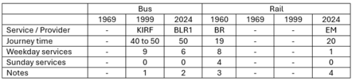
Table 2. Oakham to Melton Mowbray
Melton Mowbray to Oakham (Station Approach) via Whissendine, Ashwell and Langham. Also, four journeys / day Oakham to Langham only.
KIRF (Rutland Flyer) Corby to Melton Mowbray via Uppingham, Oakham and Cottesmore; BA2 Uppingham to Nottingham via Oakham, Langham, Whissendine and Melton Mowbray.
BLR1 Corby to Melton Mowbray via Uppingham, Oakham, Langham and Whissendine; CBR2 is Oakham to Melton Mowbray via Exton, Cottesmore and Whymondham. Also, one BLR4 service per day Melton Mowbray to Peterborough via Oakham and Uppingham (not shown in table).
Leicester to Peterborough East via Syston, Frisby, Melton Mowbray, Saxby, Ashwell, Oakham, Manton for Uppingham, Luffenham, Ketton and Collyweston, Stamford, Helpston and (for some journeys) Peterborough North.
Leicester to Peterborough via Melton Mowbray, Oakham and Stamford.
Birmingham to Cambridge / Stansted Airport via Leicester, Melton Mowbray, Stamford and Peterborough.
Birmingham to Cambridge / Stansted Airport via Leicester, Melton Mowbray, Stamford and Peterborough. Also, two early morning / late evening EMT services from Nottingham to Norwich calling at Loughborough, Melton Mowbray, Stamford and Peterborough (not included in table).
Table 3. Oakham to Uppingham
Uppingham to Stamford via Ridlington, Wing, Oakham (Railway Station Crossing), Exton, Whitwell, Empingham and Great Casterton.
KIRF (Rutland Flyer) Corby to Melton Mowbray via Uppingham, Oakham and Cottesmore; BA2 Uppingham to Nottingham via Oakham, Langham, Whissendine and Melton Mowbray.
Corby to Melton Mowbray via Uppingham, Oakham, Langham and Whissendine
Regional interurban services
In this section we consider the evolution of services from Oakham to the major surrounding conurbations of Peterborough, Leicester, Nottingham, Grantham and Corby (Tables 4 to 8). With regard to Peterborough and Leicester, the same remarks can be made as in the last section in terms of the rail services, with steadily decreasing journey times and a major improvement in service frequency. For both towns there have only ever been occasional and sporadic bus links, addressing specific leisure, employment or educational needs, with long journey times. Direct services to Grantham were an early casualty of service rationalization and were not provided after the early 1970s.
In the early 1960s train services were provided from Nottingham to Melton Mowbray, Oakham, Corby, Kettering and beyond. Services on this line were a major casualty of the Beeching closures and there are now only very limited rail services to both Nottingham and Corby. Whilst there was quite a good bus service from Oakham to Nottingham in 1999, operated by Barton, this did not last and there are now no direct bus services to that city. There are, however, regular services to Corby that run through Oakham to Melton Mowbray. In 1999 these were provided by Kinchbus and marketed as the Rutland Flyer. Now the service is operated by Blands. Journey times are of the order of 40 to 50 minutes.
Table 4. Oakham to Peterborough
Melton Mowbray to Peterborough via Langham, Oakham, Uppingham and South Luffernaham.
Leicester to Peterborough East via Syston, Frisby, Melton Mowbray, Saxby, Ashwell, Oakham, Manton for Uppingham, Luffenham, Ketton and Collyweston, Stamford, Helpston and (for some journeys) Peterborough North
Leicester to Peterborough via Melton Mowbray, Oakham and Stamford
Birmingham to Cambridge / Stansted Airport via Leicester, Melton Mowbray, Stamford and Peterborough.
Birmingham to Cambridge / Stansted Airport via Leicester, Melton Mowbray, Stamford and Peterborough. Also, two early morning / late evening trains from Nottingham to Norwich calling at Loughborough, Melton Mowbray, Stamford and Peterborough (not included in table).
Table 5. Oakham to Leicester
Saturdays only. Oakham (Station Road) to Leicester via Braunston, Knossington, Cold Overton and Melton Mowbray.
Leicester to Peterborough East via Syston, Frisby, Melton Mowbray, Saxby, Ashwell, Oakham, Manton for Uppingham, Luffenham, Ketton and Collyweston, Stamford, Helpston and (for some journeys) Peterborough North.
Leicester to Peterborough via Melton Mowbray, Oakham and Stamford
Birmingham to Cambridge / Stansted Airport via Leicester, Melton Mowbray, Stamford and Peterborough.
Birmingham to Cambridge / Stansted Airport via Leicester, Melton Mowbray, Stamford and Peterborough. Also two early morning / late evening trains from Nottingham to Norwich calling at Loughborough, Melton Mowbray, Stamford and Peterborough (not included in table).
Table 6. Oakham to Grantham
Oakham (Railway Station) to Grantham, calling at Cottesmore, Greetham, Market Overton and Thistleton. Also 3 journeys from Oakham to Cottesmore only.
Table 7. Oakham to Nottingham
Nottingham to Uppingham via Melton Mowbray, Whissendine, Langham and Oakham.
Nottingham to Kettering, via Old Dalby, Melton Mowbray, Oakham, Manton for Uppingham, Gretton, Corby and Kettering, Two or three of these were from Nottingham (and beyond) to London St Pancras.
Nottingham to Norwich calling at (Leicester), Loughborough, Melton Mowbray, Oakham, Stamford and Peterborough (early morning and late evening only)
Table 8. Oakham to Corby
Corby to Melton Mowbray via Uppingham, Oakham and Cottesmore.
Corby to Melton Mowbray via Uppingham and Oakham
Nottingham to Kettering, via Old Dalby, Melton Mowbray, Oakham, Manton for Uppingham, Gretton, Corby and Kettering. Two or three of these were from Nottingham (and beyond) to London St Pancras.
Melton Mowbray to London St Pancras calling at Oakham and Kettering.
Long distance services
The three long-distance services we consider are Oakham to Birmingham, Cambridge and London (Tables 9 to 11). All of these are rail based. The first two reflect the changes described above to the Leicester to Peterborough services with a significantly increased number of services and steadily reducing journey times. The London situation is very different. When services ran from Nottingham to London via Oakham in the early 1960s, there were four trains to and from London each day. After Beeching these were withdrawn completely and it is only in recent years that one journey, from Melton Mowbray to London has been reinstated. Thus whilst there has been considerable improvement in east / west connectivity, north / south connectivity has been reduced to a nominal level.
Table 9. Oakham to Birmingham
Birmingham to Cambridge / Norwich via Leicester, Melton Mowbray, Stamford and Peterborough.
Birmingham to Cambridge / Stansted Airport via Leicester, Melton Mowbray, Stamford and Peterborough.
Birmingham to Cambridge / Stansted Airport via Leicester, Melton Mowbray, Stamford and Peterborough
Table 10. Oakham to Cambridge
Birmingham to Cambridge via Leicester, Melton Mowbray, Stamford and Peterborough.
Birmingham to Cambridge / Stansted Airport via Leicester, Melton Mowbray, Stamford and Peterborough. Birmingham to Cambridge / Stansted Airport via Leicester, Melton Mowbray, Stamford and Peterborough
Table 11. Oakham to London
Nottingham to Kettering, via Old Dalby, Melton Mowbray, Oakham, Manton for Uppingham, Gretton, Corby and Kettering. Two or three of these were from Nottingham (and beyond) to London St Pancras.
Melton Mowbray to London St Pancras via Oakham and Kettering
Other services
When looking at the information available from the sources listed above, it is clear that there are two broad categories of bus service that are not fully represented – very local services in and around Oakham and the nearby villages; and long-distance coach services. With regard to the former, it is known that local companies such as Blands provided specific services to places of work and education and indeed that still continues in the latest timetable. These are usually one or two journeys a day with no wider public transport relevance. Als Rutland County Council operate a minibus Rutland Hopper service around the town to out-of-town stores and local villages.
It is also clear that some long distance coaches operated through Oakham, but these are not easy to find, usually occurring in specific operators timetables. For example, in 1968 Barton operated a long-distance coach service between Corby and Glasgow (presumably for steel worker s to visit families), with daytime trips on Sunday, Monday and Wednesday, and overnight trips on Friday and Saturday, that picked up and dropped off at the Crown Hotel. Similarly in 1969 Trent Motor Traction, based in Derbyshire and Nottinghamshire ran weekend services from Derby and Nottingham to Southend on Sea, Cambridge and Clacton that ran through Oakham, picking up and setting down at the Market Place. There were no doubt other similar occasional services.
Conclusions
So what can one conclude from the data presented above? Firstly with regard to rail services, it is clear that there have been major improvements in connectivity to the east and the west, with reducing journey times and increased frequencies. That being said, current reliability and punctuality is poor and requires improvement. Services to the north and south have however seen major degradation and are now only represented by one journey a day to London. With regard to bus services, in some sense these have seen little change, with journey times and frequencies on most routes remaining broadly constant, at least on weekdays. That being said, there have been some losses – to Grantham and Nottingham in particular, Sunday services are non-existent and evening services have been severely cut back, Perhaps more importantly the service times and frequencies that were acceptable in the 1960s now simply represent a very basic service that is not attractive to most car-owning travelers.
Since moving to Rutland last summer, I have come to realise that there are a number of enigmas in the early history of the county. Firstly, there is the fact that the county was the last one to be formed, and at Domesday, the northern Wapentakes of Alstoe and Martinsley were a detached part of Nottinghamshire, and the large double-hundred of Witchley in the south was part of Northamptonshire. In his consideration of this issue, Phythian-Adams (1), suggests that there was an underlying unity to the area that was to become Rutland, as it was formed from the dower lands of the late Mercian and Anglo-Saxon queens, and as it was also a Royal Forest, and that the split between Nottinghamshire and Northamptonshire occurred at some point during the period of the five Viking boroughs. This seems to have been generally accepted and seems to me quite plausible. Phythian-Adams also speculates that this area might have a longer history as a discrete unit. I have taken these thoughts a little further in a recent blog, and, noted that Rutland is essentially the upper catchment of the River Welland, whilst neighbouring South Kesteven is the catchment of the River Glen that joins the Welland east of Stamford. This of itself falls into the pattern of some early Anglo-Saxon polities in being based on river catchments, but the fact that both rivers run into the heavily managed fenland, in this case in the region of the Spalde of the Tribal Hidage (2) suggests that both Rutland and Kesteven would have required some authority, at least in terms of water management. I went further and suggested that these two polities could have been the East and West Wixna mentioned in the Tribal Hidage, as the order in which that document lists the polities in the fenland area, places them between the Gyrwe around Peterborough on the Nene and the Spalde to the north i.e. consistent with the geographical locations of Rutland and South Kesteven.
The second enigma is that within the county there are a number of place names that refer to the Anglo-Saxon tribe of the Hwicce. These have been investigated by Green (3) and include Witchley Warren, Witchley hundred, Whissendine and Witchely Leys. The Hwicce of course are known in the historical record as a West Midland polity, based around Worcestershire and Gloucestershire, so the existence of these names in Rutland is somewhat odd, and suggests that at some point in their history, at least a part of the Hwicce were resident in Rutland – probably before they became established in the Worcestershire area, so perhaps in the early sixth century. Phythian Adams (1) also points out that, on the western boundary of the county, there are a number of place names that refer to beacons, military guard posts etc., which suggest that the Rutland Hwicce had need to be wary of their neigbours to the west. I have addressed this issue in a second recent blog post, suggesting that the possible area name of East Wixna is another indication of the presence of the Hwicce, and also pointing out that in 1066 Queen Edith, the wife of Edward the Confessor, as well as holding much of Rutland in Lordship, was also the Lord of a large cluster of manors in Herefordshire, in the area usually ascribed to the Magonsaete tribe, sometimes referred to as the Western Hecani, or Hwicce. How far back these holdings go would require a detailed study, but on the face of it, it does suggest enduring links between Rutland and what was to become the main territory of the Hwicce.
There is however a third enigma – the often-observed fact that the place names within Rutland are overwhelmingly English, despite being surround by Danish areas, which suggest that although the Danes might have had political control of the area, they did not settle there. Phythian-Adams (1) speculates that this was due to an agreement in 893 between a representative of King Alfred of Wessex and the Danes of York, who seemed to be exercising political control in the area, because Rutland was the dower of the late Mercian queens – and thus of his own sister Aethelswyth, the wife of the last King of Mercia, Burged who was deposed by the Danes, and possibly his daughter Aethelflaed, the Lady of the Mercians who was married to Ealdorman Aethelred. Whist this plausible, I do not find it wholly convincing as a reason for Wessex to strike such a bargain with the Danes, presumably at some unspecified cost. In what follows I speculate on a further reason why the rules of Mercia, and later Wessex, might wish to retain Rutland as a specific English-speaking area. I will base this on the work of Green (4), who proposed a wave of migrations eastwards and northwards from Lincolnshire in the early sixth century, and of Jones (5) who mapped the place names associated with the early members of the Mercian royal house.
East of England migrations
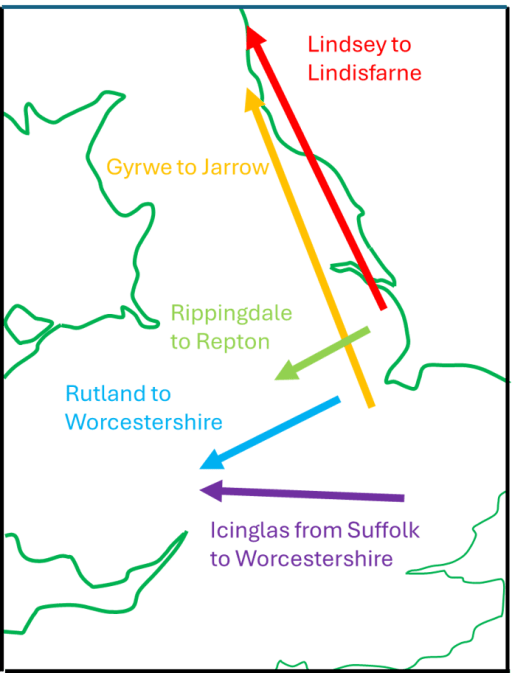
Through a detailed consideration of place and tribal names Green (4), in her extensive discussion of Anglo-Saxon Lindsey, shows, conclusively to my mind, that Lindisfarne off the coast of Northumbria, was colonized by settlers from Lindsey in Lincolnshire. She puts this migration in the early part of the sixth century, on the basis that the Anglo-Saxon Chronicle shows Anglo-Saxon expansion from Lindisfarne after 550, with activity around Bamburgh and Yeavering on the mainland. Further she notes that the other main centre of Northumbrian activity was at Jarrow, the early forms of the name are Gyrwe – the same as the people from the Tribal Hidage in the region of Peterborough. Thirdly she notes that Rippingale in Lindsay is cognate with the name Hrepingas, the tribe in the area around the Mercian ecclesiastical centre of Repton. She then further refers to the point that has been made above, that there are many place names in Rutland that relate to the Hwicce. All these relationships and possible migrations are shown on Figure 1. Taken together they show a considerable Anglo-Saxon expansion from the Lincolnshire / Fenland / Ruland area. It seems to me likely that these all occurred in the first part of the sixth century, on the basis of the formation of Northumbria, and that by a century later, Mercia and the kingdom of the Hwicce were well established. This timing suggests that this movement of peoples was associated with the climate catastrophes of the 530s (possibly due to a major volcanic explosion) and the spread of the Justinian plague across Europe in the 540s (6).
Figure 1. 6th Century Anglo-Saxon migrations from the East Midlands (after Green (4))
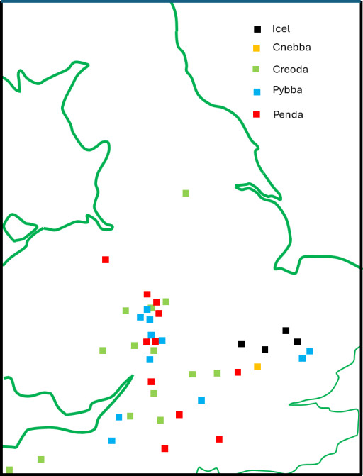
The early Mercian dynasty
The early kings of Mercia identified themselves as the Iclingas – the descendants of Icel. The early genealogies give their order as Icel, Cnebba, Cynewald, Creoda, Pybba and Penda, although there is much doubt about the veracity of the earlier names. However, Penda can confidently be placed in the early to mid seventh century. Counting back the generations, on the assumption that the list is vaguely reliable, puts the early names around the end of the fifth and beginning of the sixth century. Now Myers has pointed out that there are a series of place names in the Cambridgeshire / Suffolk area that can be associated with those of the early kings – Ickleford, Ickleton and Icklingham – and perhaps indicate a migration route. These are also shown on the map of Figure 1. However, it has long been known that there are clusters of place names in the Worcestershire / Gloucestershire area that are associated with the names of the later kings from Creoda onwards. These have been mapped by Jones (5), and a composite map for the kings up to Penda, redrawn from the data in Jones’ paper with some added information, is shown in Figure 2. The chronological procession from Suffolk and Cambridgeshire in the east to the West Midlands in the west is clear, and the clustering in the Worcestershire / Gloucestershire area is very striking. Despite the fact that these are Mercian kings, and early Mercia can be placed fairly confidently to the north in Staffordshire and Derbyshire, it seems that the kings from Creoda to Penda were closely associated with the region of the Hwicce.
Figure 2. Place names associated with the early Mercian kings (after Jones (5))
Synthesis
To sum up what has been written above, in the first half of the sixth century, there was a major movement of Anglo-Saxons (culturally if not ethnically) from the East Midlands to the West. The early ruling dynasty of Mercia was part of this, and place name evidence suggest that they were associated with the tribal area of the Hwicce in Worcestershire and Gloucestershire. Whilst the Hwicce seem to have migrated from the Rutland area, the dynasty of Icel seems to have migrated from somewhat further south in East Anglia. This does however bear on the third enigma outlined above. The fact that Creoda, Pybba and Penda had very close associations with the Hwicce area, could mean that later members of the dynasty regarded the territory of the Hwicce as their homeland of origin, and, by extension, Rutland came to be of ancestral importance for them. So my basic suggestion, which as ever is only really speculation, is that the later Mercian monarchs and their Wessex supporters and successors did all they could to keep Rutland from Danish settlement, not only because it was the dower land of their queens, but also because they regarded it as their place of origin, to which they had a significant historical, and perhaps emotional, attachment. Whatever price they paid to the Danes not to settle in the area was felt to be worth it to protect their (supposed) ancestral homeland.
The articles by Phythian-Adams (1977,1980) from several decades ago, and the more recent one by Green (2016) have highlighted the rather odd fact that within Rutland in the East Midlands, there are a number of place names that refer to the Hwicce, an Anglo-Saxon tribe whose territory was in the West Midlands, particularly in Worcestershire and Gloucestershire. In this short blog I firstly rehearse some of the findings of these authors and then extend the discussion somewhat, presenting some further, although tenuous, evidence of links between Rutland and the Hwicce based on consideration of the early Anglo-Saxon document known as the Tribal Hidage, and on estate holdings at the time of Domesday.
Place names
We begin by setting out the place name evidence as outlined by Phythian-Adams and Green. They showed that there are a number of place names in Rutland that strongly suggest an association with the Hwicce .These ae as follows.
Witchley Warren/Wicheley Heath – a farm in Edith Weston, but originally covering a significantly larger common area;
Withley East and Witchley West hundreds – the extensive area in the south of Rutland, that was included in the Northamptonshire Domesday;
The village of Whissendine in the north west of Rutland;
Witchley Leas on Whissendine parish.
In addition, around 20 miles to the south in Northamptonshire there is the parish of Whitson. A full discussion of these names, including their earlier forms is given in Green (2016) and their association with the name of the tribe of Hwicce is clear.
Topography and the Tribal Hidage
In an earlier blog I have shown that the current area of Rutland, plus the area around Stamford, matches fairly closely the catchment of the Upper Welland, whilst the catchment of the Glen, which joins the Welland below Stamford corresponds to at least the southern part of the Lincolnshire district of Kesteven. After the junction of the Glen and the Welland, the Welland flows towards Spalding – the territory of the early Anglo Saxon tribal grouping of the Spalde on the margins of Fenland . This was an extensively managed area, with well-defined common rights (Oosthuizen, 2017). In particular the control of water levels was vital to the pastoral economy, and thus the amount entering the area from the Welland was of crucial importance. This level of importance, and the fact that the two catchments of the river became well defined administrative areas, argues for their early definition as coherent units. Taking this further, I suggested that these land units corresponding to Kesteven and Rutland could be identified with the East and West Wixna of the Tribal Hidage (Hart, 1971), the first of 300 hides and the second of 600 hides, where the hide is an economic rather than a geographical measure. The reason for this assertion was that, in the listing of the Tribal Hidage these polities came between the Spalde and the South and North Gyrwa, which are known to be in the Peterborough area*. Although I am neither a linguistic nor a place name expert, it seems to me that the name of Wixna is also possibly associated with the name of Hwicce, and suggests that at the time of the production of the Tribal Hidage, which I take to be in the early seventh century following the argument of Higham(1995) at least part of the Hwiccan peoples populated the areas of Rutland and Kesteven.
*I also made the alternative suggestion that Rutland Kesteven could be identified with the East and West Willa, with names that are cognate with Welland, but on reflection I think their location in the list of the Tribal Hidage makes this less plausible.
Domesday and Queen Edith
It is well know that in 1066, Queen Edith, the wife of Edward the Confessor, held much of what was to become Rutland in Lordship, particularly in the southern Wycherley hundred, which was then part of Northamptonshire. However these were far from her only land holdings. The full extent of them is revealed through the analysis of the Open Domesday web site (Open Domesday, 2023), and shown on the map of Figure 1 below.
Figure 1. The Domesday holdings of Queen Edith (from Open Domesday)
The holdings where Edith was either Lord or Overlord, are shown by small red circles. There is a general dispersed group of holdings scattered across the north London / Oxford / Milton Keynes area, with further scattered holdings across the south Midlands. There are, however, a number of clusters. The Rutland cluster is indicated by the red circle labelled as A. The largest cluster is in the Herefordshire / Worcestershire area and is labelled B, with smaller clusters around Grantham (C) and Horncastle (D), with a further scatter across north Lincolnshire. Cluster B is of particular interest, as this lies in the western part of the territory of the Hwicce, which extends through Worcestershire and Gloucestershire. More specifically it lies within the territory of the Magonsaete, an early polity about which little is known (Pretty 1989), but which is sometimes referred to is referred to as the western Hecani – probably another name for Hwicce. Thus, we possibly have here another instance of Edith, as the Queen of England, and the successor of the Mercian Queens, as having much land in the predominantly Hwicce area, providing another link between the Hwiccan lands of Rutland and the larger Hwiccan kingdom in the west.
But what of the other clusters – can any Hwiccan connection be demonstrated between these and the Hwicce? Here the evidence is tenuous at best. The holdings around Grantham are in the Wapentake of Winnibriggs. This something of an odd name, and Coates (2009) would see it as a compound of a personal name and a bridge. I would make the very tentative suggestion however that this might be associated with the Hwicce, but this is very speculative. With regard to the Horncastle cluster, I can find no relationship at all with the Hwicce in terms of place names. For both however, it may be that historians of the locality may be able to identify any connection if it actually exists.
One further, tenuous connection exists between the Northampton shire village of Whitson mentioned above (which does have a Hwiccan association) with the isolated Queen Edith holding of Finedon. These are in the same area of the county, about 10 km apart. I will leave it to the judgement of the reader as to whether or not any weight should be placed on this.
References
Coates R (2009) “Reflections on some major Lincolnshire place names. Part Two: Ness wapentake to Yarborough”, Journal of the English Place Name Society, 41, 57-102