

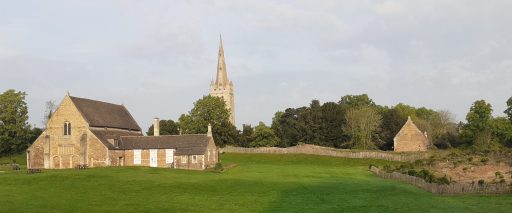
The Vicar Boards at All Saints Oakham
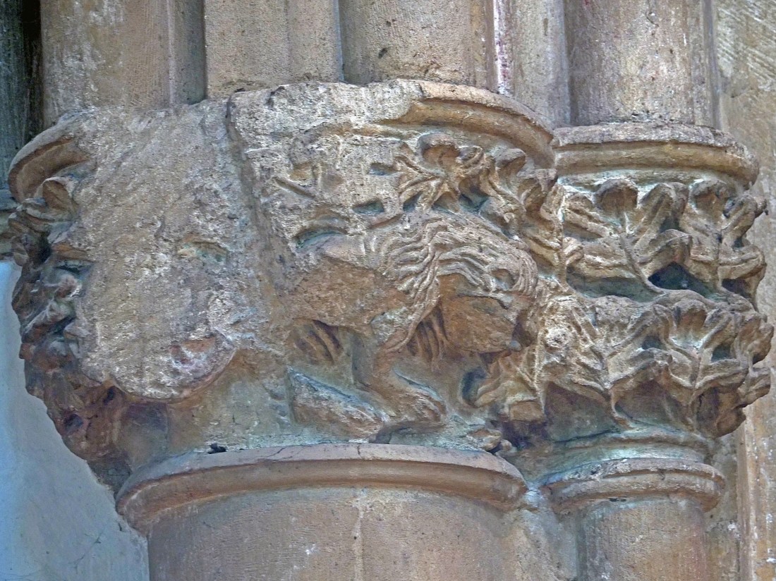
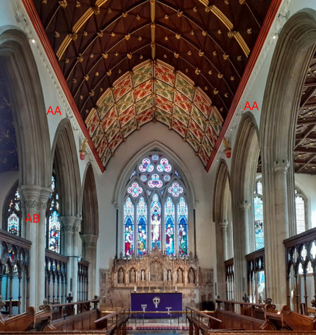
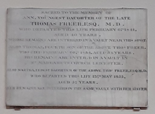
Two large inscribed boards at the west end of All Saints church list the vicars of the church from 1227 to the present day (figure 1). This list matches those found in church guides written over the last 100 years and date back to the primary research found in a 1903 article in the Rutland County Magazine and Historical Record of 1905. Whist this list is quite comprehensive, a more detailed resource is now available – the The Clergy of the Church of England Database 1540-1835 (CCEd) which contains information from a wider variety of sources than were available in 1905. In this post we look at the information that can be obtained from this database about the life and times of Vicars of Oakham for the period 1540-1835 – roughly corresponding to the top half of the second board in figure 1.
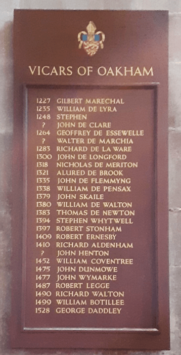
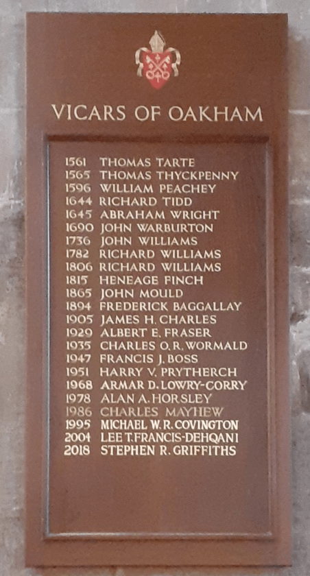
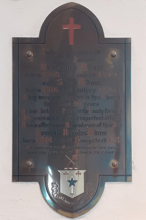
Figure 1. The Vicar boards at All Saints Church
The database listing
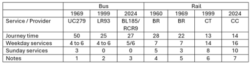
A listing of the Vicars of Oakham from the database is given in Table 1 below. The table gives the names and the year and type of the event recorded. The hyperlinks on the names link to the information held in the database of the career that particular person, both at Oakham and elsewhere, and the hyperlinks in the “View” column link to details of the particular event recorded. The types of event are as follows.
- Appt (Admission) – Definition not clear
- Appt (Collation) – Candidate appointed by the Bishop as Patron, combining presentation and institution
- Appt (Institution) – Appointment of the candidate to the living by the Bishop
- Appt (Licensing) – Appointed with a Bishop’s license
- Appt (Presentation) – Patron presents the candidate to the Bishop
- Disp (Dispensation) – Some variation of normal practice
- LibC – Liber Cleri – Name found in Visitation records
- Subsc – Subscription to various oaths
- Vac (Death) – Vacancy caused by death
- Vac (Resignation) – Vacancy caused by resignation
| Archbolde , Willimus | 1561 | Appt (Resignation) | Vicar | View |
| Tarte , Thomas | 1561 | Appt (Institution) | Vicar | View |
| Bartlett , Johannes | 1565 | Vac (resignation) | Vicar | View |
| Thyckpennye , Thomas | 1565 | Appt (Institution) | Vicar | View |
| Peachie , Willimus | 1596 | Appt (Institution) | Vicar | View |
| Greene, Johannes | 1609 | Appt (Presentation) | Vicar | View |
| Peachie , Will | 1629 | Disp-App | Vicar | View |
| Tyd , Richard | 1644 | Appt (Admission) | Perpetual Vicar | View |
| Wright, Abraham | 1662 | Subsc | Vicar | View |
| Wright, Abraham | 1664 | Libc | Vicar | View |
| Warburton, John | 1691 | Appt (Collation) | Vicar | View |
| Warburton, John | 1736 | Vac (Death) | Vicar | View |
| WIlliams, John | 1736 | Appt (Institution) | Vicar | View |
| Williams , John | 1777 | Libc | Vicar | View |
| Williams , John | 1782 | Vac (Death) | Vicar | View |
| Williams , Richard | 1782 | Appt (Institution) | Vicar | View |
| Williams , Richard | 1806 | Vac (Death) | Vicar | View |
| Williams , Richard | 1806 | Appt (Institution) | Vicar | View |
| Williams , Richard | 1806 | Vac (Death) | Vicar | View |
| Williams , Richard | 1806 | Disp (Dispensation) | Vicar | View |
| Williams , Richard | 1815 | Vac (Death) | Vicar | View |
| Finch , Heneage | 1815 | Disp (Dispensation) | Vicar | View |
| Finch , Heneage | 1815 | Appt (Institution) | Vicar | View |
Table 1. The Vicars of Oakham from The Clergy of the Church of England Database 1540-1835 (CCEd)
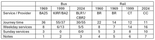
Not only does the database list the Vicars of Oakham, but also those who were curates or licensed preachers, and these are shown in Table 2. The intermittent nature of this listing suggests that this list is far from complete. Indeed the database also lists curates in the associated parishes of Egleton, Barleythorpe, Langham and other chapels, who were probably under the oversight of the vicar of Oakham.
| Gooche, Nathaniel | 1612 | Appt (Licensing) | Preacher | View |
| Chamberlain , Jacob | 1639 | Appt (Licensing) | Curate | View |
| Warburton, Charles | 1722 | Appt (Appointment) | Curate | View |
| Holwell, Benjamin | 1725 | Appt (Licensing) | Curate | View |
| Stokes, Charles | 1728 | Subsc | Deacon | View |
| Stokes, John | 1728 | Subsc | Deacon | View |
| Smith , William | 1776 | Appt (Licensing) | Curate | View |
| Smith , William | 1777 | Libc | Curate | View |
| Orme ? , Thomas | 1777 | Libc | Curate | View |
| Currie , John | 1783 | Appt (Licensing) | Curate | View |
| Barton , Matthew | 1808 | Appt (Licensing) | Curate | View |
| Jones , John | 1816 | Appt (Licensing) | Curate | View |
| Macfarlane , Robert | 1821 | Appt (Licensing) | Curate | View |
| Breynton , John Henry | 1821 | Appt (Licensing) | Curate | View |
| Foxton , George Lardner | 1825 | Appt (Licensing) | Curate | View |
| Philpot , William Doveton | 1833 | Appt (Licensing) | Curate | View |
| Heaton , George | 1834 | Appt (Licensing) | Curate | View |
Table 2. Other ministers at Oakham from The Clergy of the Church of England Database 1540-1835 (CCEd)
In what follows we delve deeper into the database to learn more about the clergy named in the above tables.
Reformation, counter Reformation and the Elizabethan settlement (1540 -1596)
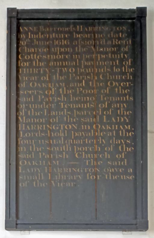
Henry VIII died in 1547, and was succeeded by his son Edward VI (1547-1553). In his reign the Protestant Reformation took hold, with the publication of the 1549 Prayer book in English. The situation rapidly changed when his sister Mary (1553 to 1558) came to the throne, with the Catholic Counter Reformation. This period was a time of turmoil for the church, with loyalties tested amid persecution and martyrdom. The situation stabilised when Elizabeth I came to the throne, with a return to Protestantism, but acceptance, if not approval of catholic worship as long as it was carried out discretely.
George Daddley, who appears on the board for 1528, does not appear in the database, presumably because all the information about him precedes 1540, the start date for the database. The first vicar recorded in the database after that date is William (Willimus) Archebolde who resigned in 1561. He was Vicar of Blakeskey from 1551 and presumably resigned at some time after that to take up the position at Oakham. He was also Vicar of Bugbrooke from 1560 to1561 and Vicar of Kislingbury 1559-1568. How he fared in the reigns of Edward and Mary is unknown – but he at least survived to the reign of Elizabeth. He was succeeded at Oakham by Thomas Tarte in 1561. Tarte presumably resigned after two or three years and was succeeded by John (Johannes) Bartlett (again not on the board) who himself resigned in 1565. This rapid turnover of clergy then came to an end with the appointment of Thomas Thyckpennye, who had been a curate at North Luffenham from 1562, who remained in post until 1596.
The Stuarts, the Civil War and the Restoration (1596-1691)
Over the course of the seventeenth century, the stability achieved under Elizabeth was to be lost under the Stuart Monarchs and during the Civil War and the Commonwealth. Again, this would result in far reaching disruption to he life of the church, with conflict between the episcopal Church of England and the Presbyterian parliament. However for the first 40 years of the century there was a sense of stability, with only one, long serving vicar, William Peachie. His career is well documented in the database.
- Father Thomas and born in Essex,
- Matriculated as a Pensioner at St John’s, Cambridge , Michaelmas 1582
- B.A. 1586-7; M.A. 1590; B.D. 1597. Fellow, 1590
- Ordained Deacon and Priest on the same day in 1591
- Vicar of Exton, Rutland, 1592-6.
- Vicar of Oakham, 1596-1643
- Father Thomas buried at Oakham in 1602
- Rector of Burrough-on-the-Hill, Leics., 1628-43.
- Died Oct. 6, 1643, aged 78. M.I. at Oakham.
- Father of Josias (1617), John (1620) and Samuel (1614).
Early in his incumbency, a report of a Visitation suggest the church was in poor repair.
The seats on the south aisle are all broken in the bottom and neither paved nor boarded. Pavement in the east and north aisles broken. The chancel and the chapel on the north side neither plastered nor whited…Two bell wheels broken but being mended. The communion table unfit. The linen cloths very old. The north door in decay
Peachie was buried in the chancel, with a plain gravestone, with the following inscription (The History and Antiquities of the County of Rutland, James Wright, 1684)
Subtus jacet Venerab. Vir Guil. Peachie S.T.B. quondam Coll. D. Joh. Cant. Soc. nuper bujus EcclesiaVic. Morum innocentia satis laudatus, in arte concionandi Versatiss.
Quator Trium, Insignum Theologor, Pater Soror
Qui OJob. 6.
Non tam morbo confectus, quam vivendi tedio lassatus, placide expiravit.
Dom. 1643.
Etat. 78.
Residentia, 47.
Noli vexare Quiescit.
The gravestone no longer exists. The English Translation is as follows.
Beneath lies the Venerable. Rev William Peachie S.T.B. formerly of the College of St John, Cambridge. Recently the Vicar of the Church. His innocence of morals is highly praised, he is skilled in the art of preaching.
Four Three, Insignia Theologian, Father Sister
Job 6
Not so much worn out by illness, as worn out by the tedium of life, he expired peacefully.
Died 1643
Age 78
Residence 47
Don’t bother him. He’s resting.
Peachie thus survived through the reigns of James I and Charles I, but by the time of his death, the Civil War was underway and the relative peace of the first half of the century shattered. In this context one can perhaps appreciate the world weariness expressed in the inscription. It may also be that Peachie would have been required to sign the Solemn League and Covenant – a Presbyterian document of 1643 to which all those appointed to livings were required to subscribe. There are other indications in the record that his tenure was not wholly without incident. The records indicate that in 1609 John (Johannes) Green was presented to be Vicar of Oakham by the Patron, King James. No further details are known, and this may simply be a mistake in the original record or the transcription to the database. But it might indicate some sort of conflict over the living. Then in 1612, Nathaniel Gooch was licensed as a Preacher in the parish, having been ordained deacon and priest in 1607. What this role was in relation to Peachie is unknown, and Gooch is next found in the record as being appointed Vicar of Twyford in Leicestershire in 1630. Neither Green or Gooch are on the Vicar’s board. Further to these appointments, in 1639 James Chamberlin was appointed curate of the Parish and Preacher throughout the Diocese of Peterborough. He had been a curate and preacher at Kirkby Mallory, Earl Shilton Chapel from 1633. Again what his role was in relation to Peachie’s is not clear. The record shows him again at Kirkby Mallory, Earl Shilton chapel in 1662 after the Restoration. Again, as a curate he does not appear on the Vicar’s board.
We have little information on the next vicar other than his name – Richard Tydd, who was appointed in 1644, by when the conflict between Bishops and Presbyterians for control of the church was underway. His incumbency only lasted a year and it might be that he too was required to sign the covenant, but refused to do so. The next incumbent was one of the most consequential of the period under study – Abraham Wright. Details of his career can be found on a Wkipedea page, an obviously AI written Grokipedea page, the Oxford Dictionary of National Biography and Rutland Record 8, 1988. The latter is most succinct and is reproduced below.
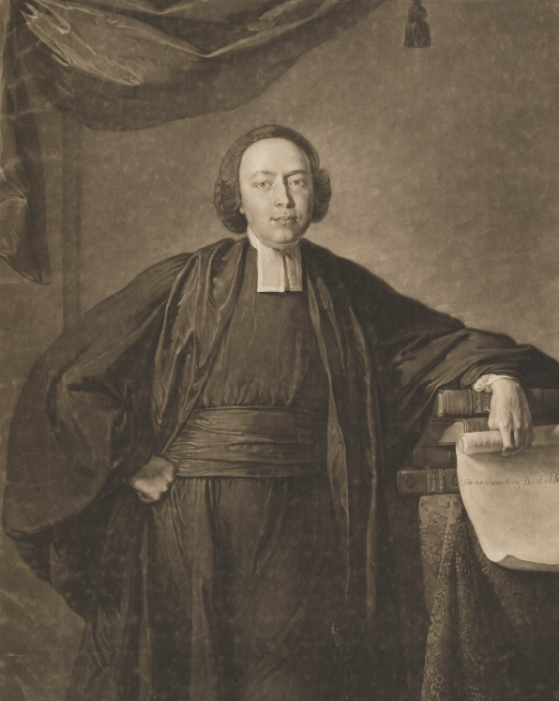
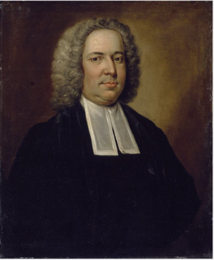
WRIGHT, Rev. Abraham (1611-90) Oakham’s notable Vicar, Abraham Wright, was born in 1611. He became a Fellow at St John’s College, Oxford, in 1632 and, in 1636, when Archbishop Laud, a former President, came with King Charles 11 and the Queen to open the new Library, it was Abraham Wright who read his own poem of welcome, later contained in “Parnassus Biceps”. During the same visit, he acted before the Royal Visitors in “Love’s Hospital”. Earlier, he had written a comic interlude, which he called “The Reformation”. Later, he published his own Sermons, including one which he preached at his own Ordination, and another given before the King. Other writings include an essay in praise of Strafford. In 1645, Wright was offered the living of Oakham by William Juxon, his President when he went up to Oxford, and by now Bishop of London but, because he could not accept the interregnum requirement to take the covenant, he was not instituted until 1660. Instead, he was active in Peckham and St Olave’s, Hart Street. When 1660 came, he was offered the Chaplaincy to the Queen of Bohemia, the new King’s sister. However, he refused this and other offers of high preferment and chose to come and remain in Oakham until his death in 1690. He married twice. His first wife bore him James, the writer of The History and Antiquities of the County of Rutland, towards which Abraham Wright provided the cost of two plates, including one of the windows of a former hall of the Hospital of St John and St Anne. As a disciple of Juxon, and as seen in some of his writings, Abraham Wright was a Laudian and, as such, insisted on ceremonial, belief in the Sacraments and the dignity of the Priesthood.
Some of his publications can be found on the web – for example “A practical commentary or exposition upon the Pentateuch” and “A Commentary on the Psalms“.
Again there seems to have been problems with the church fabric in the latter part of Wright’s incumbency, perhaps partly due to neglect during the Civil War. From the Victoria County History 1935.
In 1681 an order was made on Mr. Abraham Wright, vicar, and Mr. Burton, tenant of the Dean and Chapter of Westminster, to pave the chancel and repair the ceiling, seats and windows; and on the churchwardens to remove the rubbish out of the churchyard, repave the church alleys throughout, repair the seats and the roof and glaze the windows, rebind the Bible, provide a new Common Prayer Book, plaster and whitewash the vestry, provide a covering to one of the pewter flagons, a carpet for the Communion table of fine green or purple broad cloth, to repair the beam in the middle aisle over the minister’s pew and to take away the seats in the middle aisle.
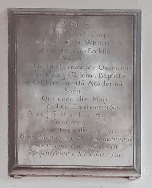
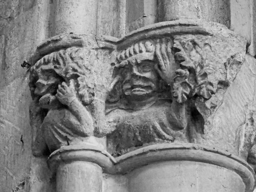
Figure 2. The Abraham Wright Memorial
The memorial to Wright still exists on the west wall of the north transept (Figure 2). It is the only monument in the church written in Latin.
P. M. S.
Prope jacet corpus venerabilis
Abraham Wright M.A. quondam hujus Ecclesia Vicarij
nata Londinensis, eruditione Oxoniensis,
olim Collegij d. Johan Baptista
in celebeuima ista Academia Socij.
qui nons die Maij
Salutis Christianæ 1690
ætatis sua 79,
Vicariatus 30, pie et tranquille expiravit
Beati mortui qui in domino moriuntur,
amodo jam dicit spiritus ut
requiescant a laboribus suis.
The English Translation is as follows.
P. M. S.
Near lies the body of the venerable
Abraham Wright M.A., formerly Vicar of this Church
born in London, educated in Oxford
formerly of the College of John the Baptist
in that celebrated Academic Society
who died on the 1st of May, 1690
aged 79
Vicar for 30 years, in piety and tranquillity.
Blessed are the dead who die in the Lord
from now on the Spirit says
that they may rest from their labours.
The other “vicar” that deserves further mention is the one who replaced Wright during the Civil War and Commonwealth – Benjamin King (1545-1660). His name, unsurprisingly, does not feature on the Vicar’s Board. After the Restoration he was ejected from the living at Oakham, one of six in Rutland to suffer that fate. But he seems to have remained in the area. From the Victoria County History.
In 1672 a licence was granted to Benjamin King, who had been intruding minister at Oakham during the time of the Commonwealth, for Presbyterians to meet at the house of Matthias Barry at Oakham. King had two daughters, one of whom married Vincent Alsop, usher of Oakham School and later an eminent minister in Westminster; the other married Robert Ekins, the first minister in the Northgate Barn.
The eighteenth and nineteenth centuries (1691-1835)
The eighteenth century again saw two long incumbencies – John Warburton from 1691 to 1736, and John Williams from 1736 to 1782. Curates become more common (or they are recorded more diligently) with six in total recorded during these incumbencies.
After the death of John Williams, his place was taken by his son Richard. He had been ordained deacon in 1771 and priest in 1772, a was curate of Stapleford in Leicestershire and vicar of Skillington in Lincolnshire from 1772. He was vicar of Oakham from 1782 to 1806 – a relatively short incumbency of only 24 years! He in his turn was succeeded by his son, another Richard, whose was ordained deacon and priest in 1801 and 1802. He was a curate in his father’s parish from 1801 until he succeeded him in 1806. In addition he was Usher at Oakham School from 1802-10. curate of Langham from 1801,vicar. of Enderby with Whetstone in Leicestershire from1803-15 and domestic chaplain to George Finch,9th Earl of Winchilsea and Nottingham of Burley House from 1806 to 1815 (the patron of the church, and thus the one who presented him to the living). Only two curates are recorded during the incumbencies of the two Richards.
A monument to all three Williams is still in place in the north transept of the church and is shown in Figure 3.
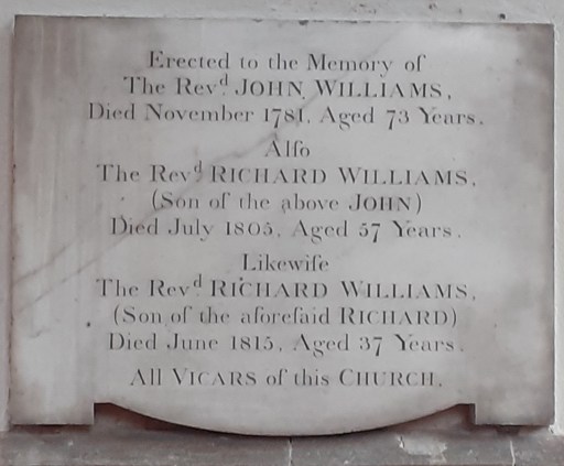
Figure 3. The Williams memorial
The final vicar in the period of the Clergy of the Church of England dataset is Heneage Finch, grandson of Heneage Finch, 3rd Earl of Aylesford (History of the Finch Family, Brayan I’Anson, 1933) and a distant relative of George Finch,9th Earl of Winchilsea and Nottingham mentioned above, the patron of the living. He was ordained deacon and priest in 1812, and was curate of Harpsden before moving to Oakham in1815. He was also Rector of Great Weldon from 1812 to 1819 and Domestic chaplain to William Legge, 4th earl of Dartmouth and Viscount Lewisham from 1815. He was another long serving vicar and died in post in 1865. It was during his incumbency that the church was restored by Gilbert Scott in 1858. Before that, as can be judged by Scott’s report, the church was again in a very poor state of repair. Indeed a lecture of 1860 that describes the pre-Restoration state of the church mentions
….that old ladies sat in church with their umbrellas up, and the pulpit to the last was in mourning for George III…
It would seem that Heneage Finch was content to let the status quo prevail and had to be urged (or one might say shamed) to let the restoration take place. In the end he contributed £200 to the overall contract cost of £4400. George Finch contributed £800.


