

The enigmas of early Rutland history
Since moving to Rutland last summer, I have come to realise that there are a number of enigmas in the early history of the county. Firstly, there is the fact that the county was the last one to be formed, and at Domesday, the northern Wapentakes of Alstoe and Martinsley were a detached part of Nottinghamshire, and the large double-hundred of Witchley in the south was part of Northamptonshire. In his consideration of this issue, Phythian-Adams (1), suggests that there was an underlying unity to the area that was to become Rutland, as it was formed from the dower lands of the late Mercian and Anglo-Saxon queens, and as it was also a Royal Forest, and that the split between Nottinghamshire and Northamptonshire occurred at some point during the period of the five Viking boroughs. This seems to have been generally accepted and seems to me quite plausible. Phythian-Adams also speculates that this area might have a longer history as a discrete unit. I have taken these thoughts a little further in a recent blog, and, noted that Rutland is essentially the upper catchment of the River Welland, whilst neighbouring South Kesteven is the catchment of the River Glen that joins the Welland east of Stamford. This of itself falls into the pattern of some early Anglo-Saxon polities in being based on river catchments, but the fact that both rivers run into the heavily managed fenland, in this case in the region of the Spalde of the Tribal Hidage (2) suggests that both Rutland and Kesteven would have required some authority, at least in terms of water management. I went further and suggested that these two polities could have been the East and West Wixna mentioned in the Tribal Hidage, as the order in which that document lists the polities in the fenland area, places them between the Gyrwe around Peterborough on the Nene and the Spalde to the north i.e. consistent with the geographical locations of Rutland and South Kesteven.
The second enigma is that within the county there are a number of place names that refer to the Anglo-Saxon tribe of the Hwicce. These have been investigated by Green (3) and include Witchley Warren, Witchley hundred, Whissendine and Witchely Leys. The Hwicce of course are known in the historical record as a West Midland polity, based around Worcestershire and Gloucestershire, so the existence of these names in Rutland is somewhat odd, and suggests that at some point in their history, at least a part of the Hwicce were resident in Rutland – probably before they became established in the Worcestershire area, so perhaps in the early sixth century. Phythian Adams (1) also points out that, on the western boundary of the county, there are a number of place names that refer to beacons, military guard posts etc., which suggest that the Rutland Hwicce had need to be wary of their neigbours to the west. I have addressed this issue in a second recent blog post, suggesting that the possible area name of East Wixna is another indication of the presence of the Hwicce, and also pointing out that in 1066 Queen Edith, the wife of Edward the Confessor, as well as holding much of Rutland in Lordship, was also the Lord of a large cluster of manors in Herefordshire, in the area usually ascribed to the Magonsaete tribe, sometimes referred to as the Western Hecani, or Hwicce. How far back these holdings go would require a detailed study, but on the face of it, it does suggest enduring links between Rutland and what was to become the main territory of the Hwicce.
There is however a third enigma – the often-observed fact that the place names within Rutland are overwhelmingly English, despite being surround by Danish areas, which suggest that although the Danes might have had political control of the area, they did not settle there. Phythian-Adams (1) speculates that this was due to an agreement in 893 between a representative of King Alfred of Wessex and the Danes of York, who seemed to be exercising political control in the area, because Rutland was the dower of the late Mercian queens – and thus of his own sister Aethelswyth, the wife of the last King of Mercia, Burged who was deposed by the Danes, and possibly his daughter Aethelflaed, the Lady of the Mercians who was married to Ealdorman Aethelred. Whist this plausible, I do not find it wholly convincing as a reason for Wessex to strike such a bargain with the Danes, presumably at some unspecified cost. In what follows I speculate on a further reason why the rules of Mercia, and later Wessex, might wish to retain Rutland as a specific English-speaking area. I will base this on the work of Green (4), who proposed a wave of migrations eastwards and northwards from Lincolnshire in the early sixth century, and of Jones (5) who mapped the place names associated with the early members of the Mercian royal house.
East of England migrations
Through a detailed consideration of place and tribal names Green (4), in her extensive discussion of Anglo-Saxon Lindsey, shows, conclusively to my mind, that Lindisfarne off the coast of Northumbria, was colonized by settlers from Lindsey in Lincolnshire. She puts this migration in the early part of the sixth century, on the basis that the Anglo-Saxon Chronicle shows Anglo-Saxon expansion from Lindisfarne after 550, with activity around Bamburgh and Yeavering on the mainland. Further she notes that the other main centre of Northumbrian activity was at Jarrow, the early forms of the name are Gyrwe – the same as the people from the Tribal Hidage in the region of Peterborough. Thirdly she notes that Rippingale in Lindsay is cognate with the name Hrepingas, the tribe in the area around the Mercian ecclesiastical centre of Repton. She then further refers to the point that has been made above, that there are many place names in Rutland that relate to the Hwicce. All these relationships and possible migrations are shown on Figure 1. Taken together they show a considerable Anglo-Saxon expansion from the Lincolnshire / Fenland / Ruland area. It seems to me likely that these all occurred in the first part of the sixth century, on the basis of the formation of Northumbria, and that by a century later, Mercia and the kingdom of the Hwicce were well established. This timing suggests that this movement of peoples was associated with the climate catastrophes of the 530s (possibly due to a major volcanic explosion) and the spread of the Justinian plague across Europe in the 540s (6).

Figure 1. 6th Century Anglo-Saxon migrations from the East Midlands (after Green (4))
The early Mercian dynasty
The early kings of Mercia identified themselves as the Iclingas – the descendants of Icel. The early genealogies give their order as Icel, Cnebba, Cynewald, Creoda, Pybba and Penda, although there is much doubt about the veracity of the earlier names. However, Penda can confidently be placed in the early to mid seventh century. Counting back the generations, on the assumption that the list is vaguely reliable, puts the early names around the end of the fifth and beginning of the sixth century. Now Myers has pointed out that there are a series of place names in the Cambridgeshire / Suffolk area that can be associated with those of the early kings – Ickleford, Ickleton and Icklingham – and perhaps indicate a migration route. These are also shown on the map of Figure 1. However, it has long been known that there are clusters of place names in the Worcestershire / Gloucestershire area that are associated with the names of the later kings from Creoda onwards. These have been mapped by Jones (5), and a composite map for the kings up to Penda, redrawn from the data in Jones’ paper with some added information, is shown in Figure 2. The chronological procession from Suffolk and Cambridgeshire in the east to the West Midlands in the west is clear, and the clustering in the Worcestershire / Gloucestershire area is very striking. Despite the fact that these are Mercian kings, and early Mercia can be placed fairly confidently to the north in Staffordshire and Derbyshire, it seems that the kings from Creoda to Penda were closely associated with the region of the Hwicce.
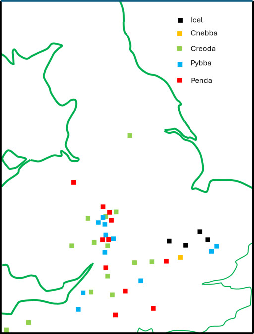
Figure 2. Place names associated with the early Mercian kings (after Jones (5))
Synthesis
To sum up what has been written above, in the first half of the sixth century, there was a major movement of Anglo-Saxons (culturally if not ethnically) from the East Midlands to the West. The early ruling dynasty of Mercia was part of this, and place name evidence suggest that they were associated with the tribal area of the Hwicce in Worcestershire and Gloucestershire. Whilst the Hwicce seem to have migrated from the Rutland area, the dynasty of Icel seems to have migrated from somewhat further south in East Anglia. This does however bear on the third enigma outlined above. The fact that Creoda, Pybba and Penda had very close associations with the Hwicce area, could mean that later members of the dynasty regarded the territory of the Hwicce as their homeland of origin, and, by extension, Rutland came to be of ancestral importance for them. So my basic suggestion, which as ever is only really speculation, is that the later Mercian monarchs and their Wessex supporters and successors did all they could to keep Rutland from Danish settlement, not only because it was the dower land of their queens, but also because they regarded it as their place of origin, to which they had a significant historical, and perhaps emotional, attachment. Whatever price they paid to the Danes not to settle in the area was felt to be worth it to protect their (supposed) ancestral homeland.
References
- Phythian-Adams C (1980) “The Emergence of Rutland and the Making of the Realm“, Rutland Record 1, 5-12
- Hart C (1971) “The Tribal Hidage”, Transactions of the Royal Historical Society, Fifth Series, 21 (1971), 133-157
- Green C (2016) “The Hwicce of Rutland? Some intriguing names from the East Midlands”, https://www.caitlingreen.org/2016/03/the-hwicce-of-rutland.html
- Green C (2020) “Britons and Anglo-Saxons: Lincolnshire AD 400-650)”, History of Lincolnshire Committee (Second edition)
- Jones G (1998), ‘Penda’s footprint? Place-names containing personal names associated with those of early Mercian kings’, Nomina, 21 (1998), 29–62.


