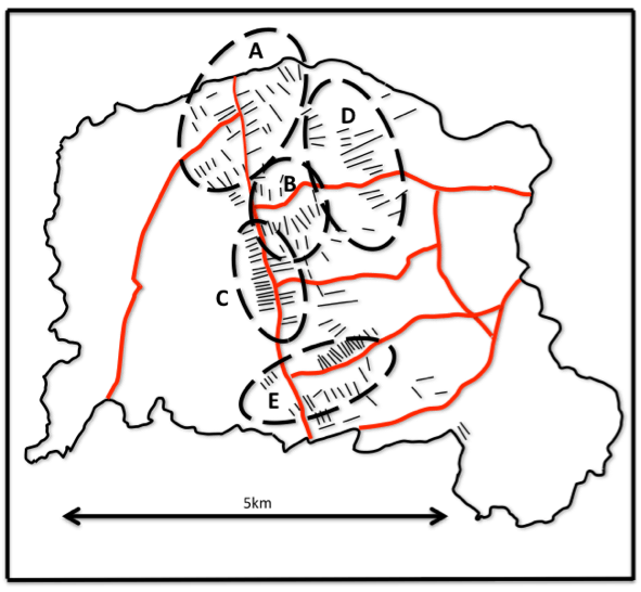
The Ashwood Hay Enclosure Act of 1776 discussed in Chapter 3 in “Kingswinford Manor and Parish” (KMP) mainly relates to the formal enclosure of around 600ha of land in the west of the parish of Kingswinford (see figure 1 which is figure 2.9 in KMP). However, it also contains extensive details of land exchanges between proprietors in the area marked as Common Fields Enclosure, which were not considered in any depth in KMP. These formalize long term leases that were entered into about a century before the enclosure to consolidate land holdings in the area, moving away from the concept of individuals holding strips in each of the three open fields. Figure 2 (figure 2.6 in KMP) shows the conjectured position of these fields that seem to have been variously named over the centuries – Wall Heath / Mosgrove field represented by the area A, Kingswinford / Old / Wartell field by area B and Wordsley / Broad field by area C.

In this blog, I give transcriptions of just two of these land exchanges as illustrations – frankly because a complete transcription would be a daunting task that I simply don’t have time for at the moment. Now it is, in the main, possible to locate the various packets of land that were exchanged from the corresponding names on the Fowler 1822 map of the parish, but that is not always the case, and the location of some of the exchanged plots below is very conjectural.
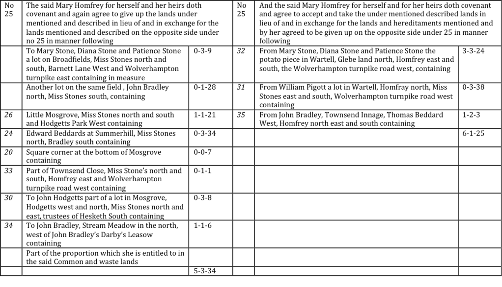
(The numbers in columns 1 and 4 refer to the exchange number. The top figure in normal type is that described below. The lower figures in italic type were handwritten and refer to the other exchange in which they were referred. The figures in colums 3 and 6 are the plot areas in acres – roods – perches)
The first exchange is shown in figure 3 for lands relinquished and received by Mary Homfrey, a relatively minor landowner in the parish. The lands that she relinquished were somewhat scattered in Wallheath / Mosgrove field and Wordsley / Broad field, mainly to the west of the Stourbridge to Wolverhampton turnpike road, but with at least one on the east in Wordsley field (near Stream Meadow) (figure 4). The lands that she received were in Kingswinford / Wartell field, and there it is clear that they all bordered land she already owned. She received about half an acre more than she relinquished, and it is stated that this will be allowed for in the division of the common lands in the Ashwood Hay enclosure.
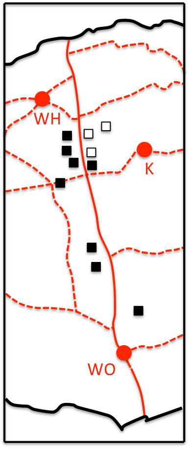
(solid red line is turnpike road; dotted red lines are other roads; red circles are Wall Heath (WH), Kingswinford (K) and Wordsley (WO); filled black squares are lands that were relinquished; open squares are lands that were received)
The second transcription is of lands relinquished and received by William Bendy (figure 5). From the tree of figure 3.6 in KMP it can be seen that this refers to William Bendy (1700-1782) the son of the second marriage of his father, William Bendy (1653-1725). He was the minor beneficiary of his father’s will, most of whose estates going to the Hodgetts and Dolman families, through the marriage of the daughter’s of his first marriage. He relinquished 22 acres of land in 5 lots. Four of these, amounting to around 4 acres, can be confidently placed in the area of Wall Heath field to the east and north of Wall Heath itself (figure 6). The major area, referred to as the Murclays, which was relinquished to John Hodgetts (1721-1789), cannot be precisely located with confidence, and was almost certainly subdivided by 1822. It is possible that it corresponds to an area of Wartell field close to Kingswinford village, that was owned by his son, John Hodgetts Hodgetts Foley (1797-1861) in 1822, which has an area of around 20 acres. It would have been close to the latters Shut End Estate, which itself had been inherited from William Bendy (1653-1725) through his great-grandfather’s marriage to William’s daughter Mary. In return the later William received six parcels of land amounting to 24 acres, with no indication that the areas would be equalized in the Enclosure allocation. These areas cannot all be located, but were clearly contiguous in the main with land he already owned, so again there seems to have been a consolidation of land. Those that can be located were to the east of Wall Heath bounded by the turnpike road. We know that William Bendy lived in the New House, somewhere on the Wolverhampton to Stourbridge Road in that area, so these lands were presumably around that house. A possible location is the triangle of land between Wall Heath and the turnpike road shown on figure 6, where the 1822 map shows a significant dwelling. On the 1882 OS map, this is named as Dawley House.
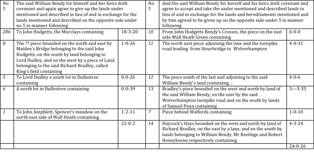
(The numbers in columns 1 and 4 refer to the exchange number. The top figure in normal type is that described below. The lower figures in italic type were handwritten and refer to the other exchange in which they were referred. The figures in colums 3 and 6 are the plot areas in acres – roods – perches)

(solid red line is turnpike road; dotted red lines are other roads; red circles are Wall Heath (WH), Kingswinford (K) and Wordsley (WO); filled black squares are lands that were relinquished; open squares are lands that were received)
If the somewhat speculative locations inferred above are accurate, then there were some interesting consequences. When the Kingswinford Railway was built in 1827, most of the land it passed over was owned by its main promoters – the Earl of Dudley and James Foster (who by then had purchased the Shut End Estate from Hodgetts-Foley for his new Iron Works). The exception was the land north of Kingswinford still owned by Hodgetts-Foley – identified here as the Murclays. The subsequent lease that was required was, to a significant extent, to determine the operation and life of the Kingswinford Railway and had various knock on effects to the whole of the Earl of Dudley’s Pensnett Railway network.
Secondly, in 1822 Thomas Dudley (1749-1825) was in residence in Shut End Hall, still at that stage owned by Hodgetts-Foley from the Bendy inheritance. The Dudley family tree is given in figure 3.10. His son Robert Dudley (1783-1856) was in residence in the house on the turnpike road identified here as the New House, by now owned by the Earl of Dudley, but again part of the Bendy inheritance. There is a pleasing symmetry here that the residences of William Bendy (1673-1725) and his son William Bendy (1700-1782) should come to be once more occupied by a father and son.
It can thus be seen from the above that the land exchanges containing the Ashwood Hay Enclosure Act contain a potential wealth of information concerning the life in Kingswinford at the time. They deserve fuller consideration. Perhaps one day I will look at them in more detail. Then again…..

One thought on “Land exchanges in the Ashwood Enclosure Act of 1784”