As I sit down to write this post, I find it hard to believe that there is anyone out there who will be interested in the ramblings that follow. But perhaps there are some from Pensnett who are as historically nerdy as I am……
In researching the history of Pensnett over the last few years, and in particular the history of the clergy of St Mark’s Church, I have come across mentions of a mission chapel in the Tansey Green area, but haven’t been able to find any further details or to locate where it was situated. There was another mission chapel in the parish of course, in Bromley, that is much better documented and had a long history. However, I have recently come across a 1949 history of the church by A Sergeant and L U Smith, written to mark its centenary (Dudley Archives LS9582/4B/21) . In that booklet there is the following little bit of information about the Tansey Green Mission Church.
In 1849 the village of Pensnett was much smaller than now, consisting of a straggling line of houses and small shops along the south side of the main road, with a few short streets leading off it to the south, The parish, however, comprised a much larger area, and in it there were two other villages or hamlets. One of these was Tansey Green, where some time about the 1860’s a small mission room was founded. No records exist of this mission apart from some notes in the Services register of the number of communicants. In the year 1888 they numbered 17 in all. Some old residents of the parish still remember the tiny mission room standing on a site on Dreadnought Road which has. now been excavated as a marl-hole, The Mission room itself was demolished some years before the turn of the century.
This short extract gives enough information to determine the location of the church. The three maps below show the Ordnance Survey maps from 1880, 1900 and 1910. Dreadnaught Road (or Nailor’s Row as it was known in the mid 19th century) can be seen extending from the bottom left of the figures to the junction with Tansey Green at the top right. The building which I think must contain the chapel is circled in red – there seems to be no other option. It can be seen to be in existence in 1880 and 1900, but by 1910, its location was the centre of what was presumably a marl hole for the adjacent brick works. This isn’t quite consistent with the extract from the history above, as the building is still shown on the 1900 map and had not been demolished by then. This could be due to the unreliable oral memories on which the 1949 booklet extract was based. or simply that the map details were slightly out of date.
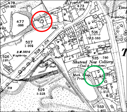
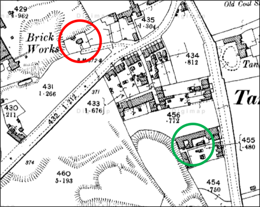
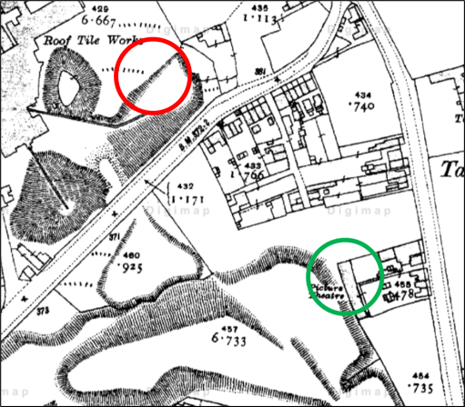
Two further points can be made. Firstly the mission chapel was very close to the Shut End Primitive Methodist church (shown by a green circle), which had a a large local congregation – so perhaps there was some level of competition there between the established church and the non-conformists. But note that the congregation abandoned that chapel in 1896 due to mining subsidence and moved to a new location on Commonside and the building became a picture house – one of the earliest in the Black Country. Secondly the building that I have identified can also be seen, with a very similar shape and ground plan in the Fowler maps of 1822 and 1840, and is listed in the Directories to those maps as “house and garden“, owned by John Hodgetts Hodgetts-Foley and occupied by John Colbourne in 1822, and owned by James Foster and occupied by Thomas Bradley in 1840. It would thus appear that the Mission Chapel was simply a converted house or part of a house.
But beyond that there is very little to say, although I find it satisfying that I have at last been able to locate where the chapel was actually situated. I am still left wandering if this is of interest to anyone else at all!

Thanks Chris. I am always fascinated to read about the history of the original Kingswinford parish and surrounding areas. Best wishes Gloria
LikeLike
As a born a bred Pensnett lad, I find this very interesting indeed!
LikeLike