The Pensnett Saxhorn Band. A post describing the life and times of the Pensnett Saxhorn Band in the mid-nineteenth century, giving a snapshot of some aspects of Black Country cultural life at the time. (March 30th 2021)
The fields that survived. An investigation of a small unit of land consisting of three late 17th century Black Country fields that escaped the ravages of mining, colliery waste and urban development to remain more or less intact to the present day. (July 23rd 2023)
The early history of the Crooked House. A post looking at the history of the Crooked House, or Glynne Arms, up to the 1870s, mainly based on early maps of the area (September 23rd 2023)
A policeman’s life – Samuel Hicklin (1858-1924). A policeman’s life – Samuel Hicklin (1858-1924). This presentation that describe the remarkable life of Sam Hicklin, the son of a farm labourer who was to progress to the highest ranks of the Staffordshire Constabulary (via Pensnett).
An Ecclesiastical Affair The video tells a true story from 1870, with many contemporary resonances, about the Victorian Black Country parish of Pensnett where the errant clergyman had a flirtation with a pupil teacher at the local school, that led to scandal in the village, a clergy discipline trial, a series of anonymous broadsheets circulating in the village making all sorts of accusations about church members (some comical, some rather nasty), and a nationally reported libel trial. Wayward clergy, scandal and libel – all the hallmarks of a good story!
This is the second of two blogs that set out a timeline of the destruction by fire and subsequent demolition of the Crooked House in Himley in early August 2023, through links to local and national press reports. It covers the period from January 2024 onwards. Earlier news items can be found in the first blog here.
In the days after the fire, there were many, very similar, press reports and thus there has been a need to be selective. In what follows, I thus use three main sources.
BBC local and national news websites, which was, and continues to be, the most comprehensive source.
The Express and Star website, which gives a local perspective. Note that many of the articles that are linked require free registration to be read.
The Guardian website – although many national newspapers reported the story in early August, the Guardian’s was probably the most comprehensive and, through its columnists, the most reflective.
I also include articles from other sources where they complement the above, including a few from overseas to demonstrate the reach of the story. I will update this list at intervals over the coming months.
In addition to the news links, there are two Facebook pages that contain news and (often robust) comments covering a range of opinion.
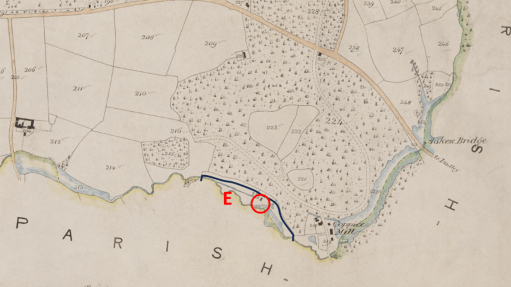
In the aftermath of the dreadful events at the Crooked House (or Glynne Arms) in August 2023 (the timeline of which I have documented here) my interests in the Oak Farm area were rekindled., and I wrote a blog post on the early history of the Glynne Arms that has been quite widely read. Perhaps the main insight to emerge from that post was to restate the often-missed fact that the Crooked House began life as a corn mill on the Oak Farm Estate owned by Stephen Glynne and evolved into a public house in parallel with the rapid industrialization of the estate in the 1840s and 1850s. This point was also made in a blog on the Black country Society site by Steve Roughton, who indeed argued that it was the existence of soft ground around the mill race that caused the building to tilt. The Oak Farm Mill stood on the Himley Brook on the boundary between Kingswinford and Himley parishes, and was powered by water from the brook, stored in a mill pool to the east and released into a mill race before rejoining the brook some way to the west. It was not the only mill in the area. To the east (i.e. upstream) the Himley Brook was joined by the Straits Brook, that formed the boundary between Himley and Sedgley parishes. Just upstream of the confluence, the waters of the Straits Brook were stored in a large mill pond that operated the Coppice Mill, owned by the Dudley Estate. This mill pond extended north to beyond Askew Bridge on the road from Himley to Dudley and is named in some sources as Furnace Pool – allegedly the site of one of Dud Dudley’s experimental furnaces in the 1620s – and the water was used to power the furnace bellows.
In this blog post, we look specifically at the watercourses that supplied the two mills, and how it evolved through the decades. It will be seen that it leads to some speculations that, in the 1840s the original Oak Farm Mill was much modified, and perhaps moved, taking water from the upstream Coppice Mill pool rather than its own. It also suggest that the Crooked House as we knew it up to August 2023 dates from that period.
Mills and watwerwheels
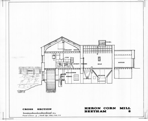
Firstly, however, we need to consider the nature of the mill itself, and in particular the possible waterwheels that were installed. Wikipedia gives a useful article on this. Basically, there are two types of wheel (although with many variants) – overshot and undershot (see Figure 1). Both of these require a differential height (or head) of water – from a reservoir of mill pool upstream, to a mill race downstream. For overshot wheels, the water fills buckets on the wheel circumference and the potential energy in the water is transferred into rotational energy in the wheel. For undershot weirs, the fall of the water upstream of the wheel decreases its potential energy and increases its kinetic energy (and thus its velocity), some of which is transferred to rotational energy in the wheel when it impinges on the vanes. A simple analysis indicates that the power output of both types of wheel is proportional to this height difference raised to the power of 1.5. Of course, the greater the head, the larger the wheel would need to be to extract the power, and the greater the mechanical challenge. The power from the wheel would have been suitably transmitted through gears to grindstones to produce flour from the cereal grains (see Figure 2 for an example from Cumbria). The miller of course would like to have a long period of operation of the wheel, but as water is released to the wheel, the level of the upstream mill pool will fall and the head available and hence wheel power will also fall. At some point the water level will fall below the level of the outlet weir or pipe in the reservoir. Thus, there is an advantage in having a large reservoir from which large quantities of water can be abstracted without too great a fall in the water level. There is no indication which type of wheel was present at the Glynne Arms.
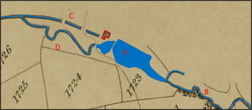
Moving on now to consider the development of the Mill and its watercourses, we will use a number of maps from a variety of sources. Each of the maps represents the same geographical area, and the buildings of the Mill / Glynne Arms are outlined in red, and the watercourses highlighted in blue. In their original forms, some of the maps did not have north at the top in the normal way, so these have been rotated, but the orientation can only be regarded as approximate. Figure 3 is an extract from the 1822 Fowler map of Kingswinford parish. The Oak Farm Mill was just outside the parish, so its appearance on the map is perhaps fortuitous. It is depicted as a simple L shaped building. The mill pool (A) is fed by the Himley Brook to the east (B) and itself feeds both the mill race (C) and the downstream channel of the brook (D). C and D join again at a point downstream. Water would have been diverted along the mill race by a system of sluices when the mill was in operation. The line of the mill race passes under the southern end of the building, which indicates that the mill wheel is at the southern end of the building. The parish boundary is defined by the brook and passes through the centre of the mill pool. The Oak Farm estate was wholly agricultural at this time. As this is a map of Kingswinford parish, nothing is shown of the area to the north of the mill in Himley parish.
Figure 4, from the Kingswinford Tithe map, surveyed in 1839, shows a very similar situation. The Oak Farm Mill is however indicated by a simple rectangular structure over the line of the mill race.
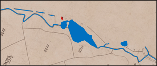
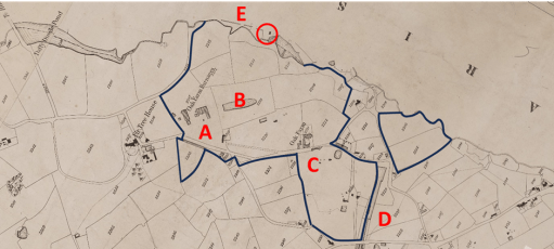
The map of Figure 5 is an extract from a document that was clearly drawn for the owners of the Oak Farm Estate and is dated November 1840. This map was used by Steve Roughton in his blog mentioned above, and I am grateful for his permission to use it here. He originally obtained it from the Clwyd archives many years ago, presumably amongst the Glynne papers relating to their home in North Wales. I have to admit that this is not a place I would have considered looking for details of the Crooked House. This shows a similar situation, with rather more detail of the watercourses to the east (i.e. upstream) and to the north (in Himley parish). In particular the buildings of Coppice Mill (A) are shown in green, with a channel leading from their vicinity into the Himley brook at the top of the Oak Farm Mill pool. The Coppice Mill pool was to the east of the mill buildings and is not shown The Oak Farm Mill itself is now represented by three distinct buildings, which suggests that the simple rectangular form in Figure 4 might be a schematic rather than realistic representation. On the other hand it suggest that the two northern buildings might have been constructed around that period. The line of the mill race (B) passes to the south of the most southerly building suggesting that the waterwheel was on the south of that building. Mine shafts of Oak Farm Colliery can be seen to the south of the brook near the downstream end of the Oak Farm Mill pool (C).
Figure 6, dating from sometime in 1841, is an extract from the Himley Tithe map. It can be seen that there have been some changes. The channel from Coppice Mill pool seems to have been replaced by one leaving the Coppice Mill pool at the north western corner (A), presumably connecting by an underground sough to the new pool on the north side of the Oak Mill pool (B). Alternatively these channels might simply represent construction phase of the new watercourse system that will be described below. This channel is distant from the Coppice Mill buildings and suggests that it is not intended as a channel to feed the mill, but rather to act as an overflow to the Coppice Mill pool, or to increase the flow to the Oak Farm Mill pool. There is perhaps an indication on Figure 6 of a channel corresponding to the mill race position (C), but this is not totally clear. The Oak Farm Mill is again shown by a simple rectangular building – again probably a simple schematic representation.
Figure 7 is an extract from a map that can be firmly dated to April 1849 that shows the whole Oak Farm Estate and may have been produced for when the Estate went on the market in that year. Is shows a similar situation to Figure 6 from 1841, although the shape of the mill pool is different and the small pool to the north no longer appears (perhaps because this wasn’t part of the Estate). The different buildings of the Corn Mill complex are individually shown.
Figure 7. Extract from Oak Farm Estate map of April 1849
Figure 8, produced for the Dudley Estate, has notes referring to the removal of some trees in 1849 and can probably be dated soon after that, perhaps the early 1850s, as the mill pool shape is similar to that of Figure 7.. The Coppice Mill race is clearer (A), and there have been some changes to the shape of the Oak Farm Mill pool (B). The major change, however, has been to the channel from the northern corner of Coppice Mill pool (C) which has now been extended as a surface channel with a sharp turn to approach Oak Farm Mill from a northerly direction (D). This looks to be a new mill race, bringing water from the higher Coppice Mill pool to the Oak Fame mill, which is here shown as a number of separate buildings, with the original mill building to the south. The change in direction would either have meant a complete rebuild of the original mill building to accommodate a new water wheel on its western side, or perhaps the relocation of the mill to the building to the north (the later public house) with a new mill wheel on its western side.
Figure 8. Oak Farm and Coppice Mills in the early 1850s
Figure 9 is the Ordnance Survey map of 1882. The situation can be seen to have changed completely with the topography being much changed by mining and other industrial activities and the development of the railway network. The Coppice Mill buildings (A) , and the Coppice Mill pool no longer exists (B), although there is a stream running through its location that runs underground to a junction with Himley Brook. In place of the mill there is a branch of the Earl of Dudley’s railway. Similarly, the Oak Mill pool is now longer visible (C), and the Himley Brook has been channeled, and west of the Oak Farm Mill (now named the Glynne Arms) runs along the old Oak Farm Mill race (D). The eastern end of the Himley brook now presumably runs underground (E). The original (southern) Oak Fam Mill building is no longer visible.
The 1882 situation is mirrored on the current Ordnance Survey map (Figure 10) and satellite view (Figure 11), where no trace of the mills and mill pools can be seen.
The main implication from the above discussion is that it is likely that, around 1841, significant works were carried out on the watercourses in the area, so that Oak Farm Mill was supplied with water from the Coppice Mill pool rather than its own mill pool. The reason for this was straightforward – this would have given a greater head of water, and thus enabled the waterwheel to produce more power for the process of corn grinding. In addition, the larger area of the Coppice Mill pool would have allowed for longer periods of water wheel operation. As there has been much change in the local topography since then due to mining and other activities, it is difficult to be precise about the magnitude of this increase in power, but an estimate can be made from the ground level heights obtained from, for example, Google Earth. The current ground level downstream of the Glynne Arms is around 84m above sea level (asl). Just upstream, in the region where the Oak Farm pool used to be, the current ground level is around 88m asl. At the site of the Coppice Mill the ground level is around 90m asl. The Coppice Mill pool extended beyond Askew Bridge on the road from Himley to Dudley. The ground level on either side of the bridge is around 98m, with the stream under the bridge a metre or so lower. There is thus a very considerable slope from Askew Bridge down to the Glynne Arms – which is of course the reason why two mills were built there. From these heights we can estimate the following.
Water level in race at Oak Farm Mill 84m
Water level in Oak Fame Mill reservoir 88m
Water level in race at Coppice Mill 90m
Water level in Coppice Mill pool 96m
Thus, the head of water available to the Oak Farm Mill was around 4m, and to Coppice Mill was around 6m. The full benefit of these heads would not be available because of head losses in pipes, and sluices etc, but we can estimate the available heads would be around 2m and 4m. Now if the waters in Coppice Mill pool were used to operate the Oak Farm Mill, the potential head available would be 12m. Much of this will be lost by the passage along the new millrace, but it would still be substantial – perhaps around 4m. This represents a doubling of the head available to the Oak Farm Mill, and, as the power is proportion to the available head to the power of 1.5, an increase in power of almost three times. Of course, a considerably bigger water wheel would have been needed to extract this power.
The provision of the Coppice Mill pool water to Oak Farm mill resulted in a ninety degree change in the direction from which the water was coming. As noted above this would either require a major change in the original mill building (the building at the south end of the building complex shown in Figure 8) to accommodate the change of direction and the installation of a larger wheel, or perhaps the construction of a new wheel on the western side of the main building (what was to become the Glynne Arms). Adding speculation to speculation, depending on the type of wheel that was used, this wheel might have rotated in a clockwise direction looking from the west. Now Steve Roughton hypothesized that the main reason for the tilt on the Glynne Arms was due to the soft ground around the original mill raise to the south of the main building. It may thus be that the moment caused by any new waterwheel on the building would have been in the direction to encourage this tilt.
Finally, some further speculation. The early maps show the Oak Farm Mill as a simple rectangular or L shaped building lying to the south of the final location of the Glynne Arms. The current building does not appear on maps in a recognizable form till the 1840s. Thus it may be that the Glynne Arms building was constructed at this period, possibly as a replacement mill when the watercourses were modified. Certainly in the 1841 census, the occupier of the property, John Cartwright was referred to as a farmer, miller and beer house keeper, so the Oak Farm Mill buildings also served as a beer house. That being said, a number of sources give the date of the building of the Glynne Arms as a farmhouse as 1765 – although I do not know the primary source of that date. I suspect it refers to the date when the original mill was constructed.
Whether or not the speculation above has any merit, it is nonetheless clear that in the early 1850s, major construction work was carried out to increase the supply of water to the Oak Farm Mill, but that the new water courses were all swept away as heavy industry spread across the area in the later 1850s and 1860s.
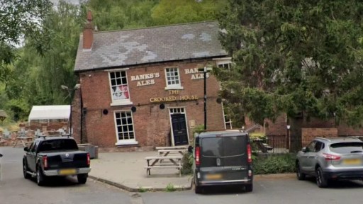
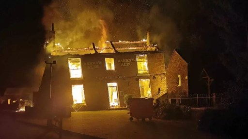
The recent burning down and demolition of the Crooked House public house in Himley in August 2023 has made news both nationally and internationally, and there are ongoing police investigations into the events and a vociferous campaign for rebuilding. In all the reporting, however, there has only been limited discussion of the history of the Glynne Arms, as it was formerly known. It is the intention of this post to fill in this gap, in terms of the early history of the property, up to around 1880. I feel this is important, as it gives something of the background and context that is perhaps somewhat lacking in the current conversations.
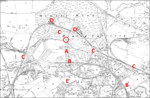
Figure 1 shows a modern Ordnance Survey map of the area. The Crooked House is indicated by a red circle on this figure and the ones that follow, which, unless otherwise stated, all show the same area to the same scale. The site of the Crooked House is situated on the north bank of the Himley Brook that flows east to west from the Old Park / Russell’s Hall area to the River Smestow, at the end of a mile long lane that leaves the Himley to Dudley Road just to the east of Askew Bridge (A). Footpaths from the site go north through Himley Wood (B), and south across an area of reclaimed industrial land (C) and the old GWR Kingswinford branch line (D) to Oak Lane (E), where there are various small-scale industrial businesses. But the area that we see now is very different from how it would have looked a hundred years ago, which itself was very different from how it would have looked a hundred years before.
Figure 1. Location of the Crooked House on a modern Ordnance Survey map
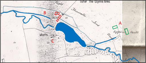
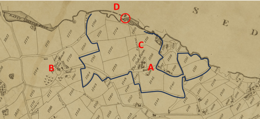
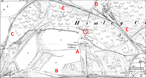
The Crooked House was built in 1765, probably as a corn mill, and first appears in the records on the 1822 Fowler map of Kingswinford parish (figure 2). The Himley Brook was the boundary between the parishes of Kingswinford and Himley, and the Crooked House, being to the north of the brook, was in Himley Parish, and thus its appearance on the Kingswinford map is quite fortuitous. At the time it was part of the Oak Farm Estate owned by Lady Mary Glynne of Hawarden in north Wales, that had been bequeathed to her and her husband by her father on her marriage to Rev Stephen Glynne in 1779 (Davies R (1983) “The Great Oak Farm smash”, Blackcountryman 16.3, 18). The estate consisted of around 90 acres of farming land mainly in the north of Kingswinford parish, with small areas in Himley and Sedgely parishes. The names of the fields give an indication of its rural character – for example Barn Close, Coppice Piece and Ox Ley. The land to the north of the Crooked House was part of the Dudley Estate and was a mixture of arable and coppiced woodland. The figure shows the boundary of the estate, Oak Farm itself (A), Fir Tree House outside the estate owned by Lord Dudley (B) and the footway from Oak Farm to the Crooked House (C). At the time, the Oak Farm estate was largely farmed by Richard Westwood, who lived at the Oak Farm. The Crooked House was at this stage, clearly a mill, and the mill race can be seen on the map passing beneath the house (D). There would have been a waterwheel operated by the water from the pool on the Himley Brook to the east, with the water being returned to the brook along the mill race. The road network at that time was very different from the modern network, although Stallins Lane and its predecessor can be seen in the bottom right-hand corners of both figures 1 and 2.
Figure 2. The Crooked House on the 1822 Fowler map of Kingswinford Parish
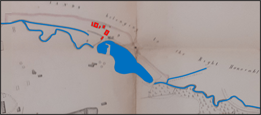
The next occurrence of the Crooked House in the historical record comes from the Tithe Apportionment records and maps in the early 1840s. The maps for Kingswinford and Himley parishes are shown in figures 3a and 3b. Note that the alignment to north is not quite consistent between the maps – the originals of both were aligned in somewhat arbitrary directions and alignment was not straightforward. In some ways the situation was very similar, with the surrounding countryside still very rural. But change was underway. The Oak Farm estate had passed to Lady Glyne’s son, Sir Stephen Glynne and in 1835 he and his partners had begun to exploit the large reserves of coal, ironstone and clay that had been found there. In the tithe allocation the estate is said to be owned by the Oak Farm Colliery Company, with the owners of the company being Thomas Bagnall, James Boydell, Baronet Sir Stephen Glynn, John Hignett, William Hignett and Charles Townshend. Already there were the Oak Farm furnaces to the south of Himley Brook (A and B), together with at least three coal pits and three ironstone pits and the associated pumping engines (C). The northern end of the Stourbridge Extension Canal can be seen on Figure 3b (D). The boundary of the estate is also shown and, whilst it remains substantially the same as in 1822, there have been some changes in the region of the Extension Canal. The somewhat reduced area of arable land (57 acres) was farmed by several tenants, with the majority (50 acres) by John Cartwright who was based at the Crooked House. In the 1841 census, his age is given as 62 and he is described as a miller, farmer and beer shop keeper. He was living with his wife Sally, aged 56, and three domestic servants. The mill race can again be seen on both maps (E). Again, the road network can be seen to be different to the current network, with the current long lane to the Crooked House not appearing.
a) Himley Tithe map
b) Kingswinford Tithe map
Figure 3. The Crooked House on the Kingswinford tithe map and the Himley tithe map
The fate of the Oak Farm company is well documented elsewhere – there seems to have been a major lack of financial control, probably to an over rapid expansion by James Boydell, who was in charge of the management of the company, that led to a level of debt that could not be serviced. The firm went bankrupt in 1849, and all its very considerable effects were put up for sale. This included
…. that conveniently situated and commodious dwelling-house, now used as a Public-house, with the garden, stabling, outbuildings and appurtenances, and water corn mill, now in the occupation of Mr. John Cartwright……
The whole estate was eventually bought by the future prime minister William Gladstone, Stephen Glynne’s brother, Stephen Glynne himself and his brother Rev Henry Glynne. It took many years, and a great deal of money, for Gladstone to resolve the financial issues of the Oak Farm concern and the other Glynne Estates, but the Oak Farm works began to prosper. However, by the 1860s and 1870s the mineral resources in the Oak Farm area were beginning to fail, and on the death of Sir Stephen in 1874, the family finally sold the estate.
During this period, the Crooked House no doubt continued as a corn mill whilst there was any arable land left to produce grain, but also came to serve the coal miners and iron workers of the area. In the 1851 census, it is simply referred to as Himley Oak Farm Mill, run by Sally Cartwright, aged 66, John’s widow, who also farmed 30 acres (note the reduction from 1840). Her son Joseph (aged 26) was the miller. It is interesting to note that Sally sister, Fanny Amis, aged 74, also lived with them. In the Directory to the Fowler map of 1822 she is recorded as being responsible for the Hollies Farm in the Old Park / Russell’s Hall area.
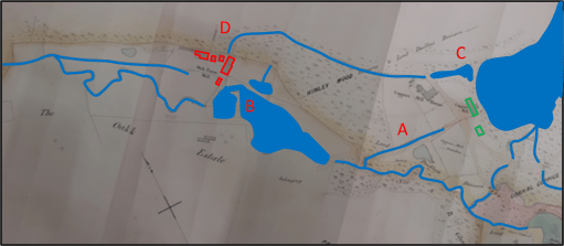
During the period of the Oak Farm concern rise and fall, the area around the Glynne Arms changed out of all recognition. Figure 4a shows the Ordnance Survey map of 1881 to the same scale as figures 1 to 3, whilst figure 4b shows the area around the Glynne Arms to a rather larger scale. The area to the south of Himley Brook had been extensively mined and the map shows the location of the Oak Farm Colliery and large areas of colliery waste (A). And the pub now seems to be surrounded by railway lines – the GWR Kingswinford branch to the south (B), at this time terminating in the Oak Farm area, and the complex tangle of lines of the Earl of Dudley’s Pensnett railway to the east, north and west (C). There are extensive railway sidings and collieries within Himley Wood itself (D). Very little undisturbed land remains. The mill pool has been drained, and the Himley Brook diverted, possibly along the mill race. A comparison of figures 1 and 4 does however show that the road network is approaching its final form and route of Oak Lane is very similar to the present and the long lane from the Himley Road to the Glynne Arms can also be seen, at least in part (E). The access still seems to be from the south however, showing that it was very much part of the Oak Farm estate.
(a)
(b)
Figure 4. The Crooked House on the 1881 Ordnance Survey map
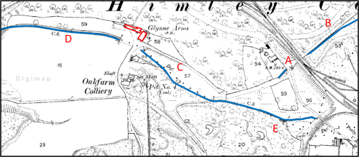
Figure 5 is taken from the Coal Authority web site and shows the mine entries that have been documented around the Crooked House. The cluster to the south of the Himley Brook (A) were part of the Oak Farm Collier and were in use from the 1860s to 1880s, and if mining subsidence caused the Crooked House to take on its iconic character before its destruction, the mines in this area are the cause.
Figure 5 Mine entries in the area of the Crooked House
In conclusion then, it is clear that the early history of the Glynne Arms / Crooked House was bound up with the development and tribulations of the Oak Farm Estate, and there was a gradual transition from its role as a Corn Mill to that of a Public House. It may be that, should the remaining foundations of the Crooked House ever be investigated as part of any rebuilding that some interesting archaeological remains might be found, pertaining to the corn mill (perhaps the wheel pit or supports, and remains of the mill race).