Introduction
A few years ago, whilst looking at some maps of the Lichfield area where I live, I was struck by the overall southwest / northeast alignment of the city, and wondered if this might hide some sort of topographical alignment based on midsummer sunrise (in the northeast) and midwinter sunset (in the southwest). The fact that the bronze-age ceremonial centre at Catholme was to the northeast of the city encouraged me in these views. Now seeing alignments of any sort from maps isn’t terribly well regarded by serious historians – those somewhat idiosyncratic types who spend their lives looking for “lay lines” connecting monuments of different types have rather made this sort of speculation somewhat less than respectable. And there is some cause for this suspicion, as alignments of different sorts can be found almost anywhere should one look hard enough. For instance I noted a few years ago that Borrowcop Gazebo, Lichfield Cathedral and Rugeley Power station were lined up very nicely, which I suspect doesn’t have much historical significance. But nonetheless these thoughts have stayed with me, and given that during the current lockdown situation I have time on my hands, I thought I would investigate this a little further. This blog post is the result. In the next section I outline how the directions of summer sunrise and winter sunset can be accurately calculated using some simple maths (readers who don’t like that sort of thing may care to pass over this section quickly). I then identify a possible midwinter sunset alignment from Catholme. Finally I speculate on what might be the implications of such an alignment,
Calculating solar alignments
Wood (1978) gives the following simple formula for calculating the azimuth (degrees from north) of the midsummer sunrise midwinter sunset

The site latitude is easily determined from geographical data. The elevation is the angle from the point of observation to the horizon over which the sun will set, corrected for the curvature of the earth and atmospheric refraction. The actual angle is easily obtainable from software such as Google Earth, and Wood (1978) gives values for the two corrections. The declination is the angle between the plane of the celestial equator and the terrestrial equator. The values of this angle for the midsummer sunrise and midwinter sunset have the same magnitude but different signs. The declination also varies with time, so the values from 4000 years ago differ from current values by about 0.6 degrees. This is quite important for the calculation and needs to be specified by a historically reasonable time being specified for the alignment in question.
The Catholme alignment
The first step in identifying whether or not there is a possible solar alignment is to identify the end points of such an alignment. So we begin with Catholme itself. The ceremonial complex is shown in figure 1. Essentially there are three monuments within the complex – a cursus dated to around 3000BC; a sunburst monument due east of the cursus, characterised by post holes radiating from the centre, and a Woohenge monument, characterised by concentric circles of post holes, to the east of the sunburst monument and slightly to the south. The Sunburst and Woodhenge monuments have been dated to between 2600 and 2400BC and remained in use for several centuries. There thus seem to be three possible starting points for the alignments, at each of the three monuments.
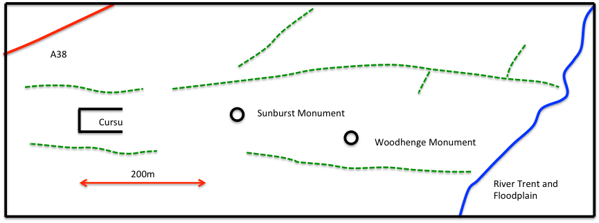
Figure 1 Sketch of the Catholme complex (Chapman et al, 2010)
But what of the other end of the alignment? In the first instance I expected this to be in the Lichfield area, but a study of the topography profiles (using Google Earth) on a south-westerly line from Catholme through Lichfield shows that Lichfield lies in a hollow and can’t be seen from Catholme. Also the horizon from Catholme is well beyond Lichfield in the Walsall Wood / Pelsall area. An investigation of maps of this area however revealed a very suitable location in Castlebanks (the site of an Iron Age Hill fort), a prominent hilltop that would have been on the horizon from Catholme and would act as a natural marker for observing the setting of the sun.
So as a first step, I calculated the directions from the three Catholme monuments to Catlebanks, simply using the longitude and latitude values for each of the sites. These are as follows, with direction measured clockwise from north.
Cursus to Castlebanks 225.7 degrees
Sunburst monument to Castlebanks 226.4 degrees
Woodhenge monument to Castlebanks 227.4 degrees
So there is a difference of around two degrees in the alignments from the various Catholme monuments. The next step is to find the direction of the midwinter sunset from Catholme around 2500BC. The latitude of that site is 52.74 degrees and the elevation can again be found from the profile produced by Google Earth. With the corrections specified by Wood (1978) this value comes out close to zero at -0.2 degrees. Wood (1978) gives a declination of – 23.98 degrees for 2500BC for the midwinter sunset. Putting these values into the above equation gives a value of 228.1 degrees for the midwinter sunset as seen from Catholme. This figure changes slightly to 228.0 degrees using the declination for 3000BC. Using the current value of declination, gives a direction of 229.1 degrees. Also of course there would be an offset of up to -0.5 degrees depending upon how the observer defined the sunset, and the particular topography that ultimately obscured it, giving the most likely value as being around 227.6 degrees. On this basis, the Woodhenge to Castlebanks line seems the most likely alignment. This is shown in the figures below. Figures 2 and 3 are Google Earth screenshots ands show the complete alignment and an expanded view of the alignment over the Lichfield area. Figure 4 is the elevation profile for the whole alignment. It can be seen that this line passes over Lichfield as expected, but its exact course is of interest. It passes over Greenhill (where the church of St Michael stands) and over the high ground at Pipehill, the source of the springs which provided water to Lichfield for many centuries. In fact from Carholme the midwinter sunset in 2500BC would have taken place over a line of hills – Greenhill in the foreground, the Pipehill ridge behind it and Castlebanks on the horizon. The midwinter sunset alignment here is so good, I do not think it can be accidental. The lining up of three prominent hills on a midwinter sunset alignment was probably just too good to miss for a Bronze Age priest who wanted to add another solar alignment to his ceremonial complex!
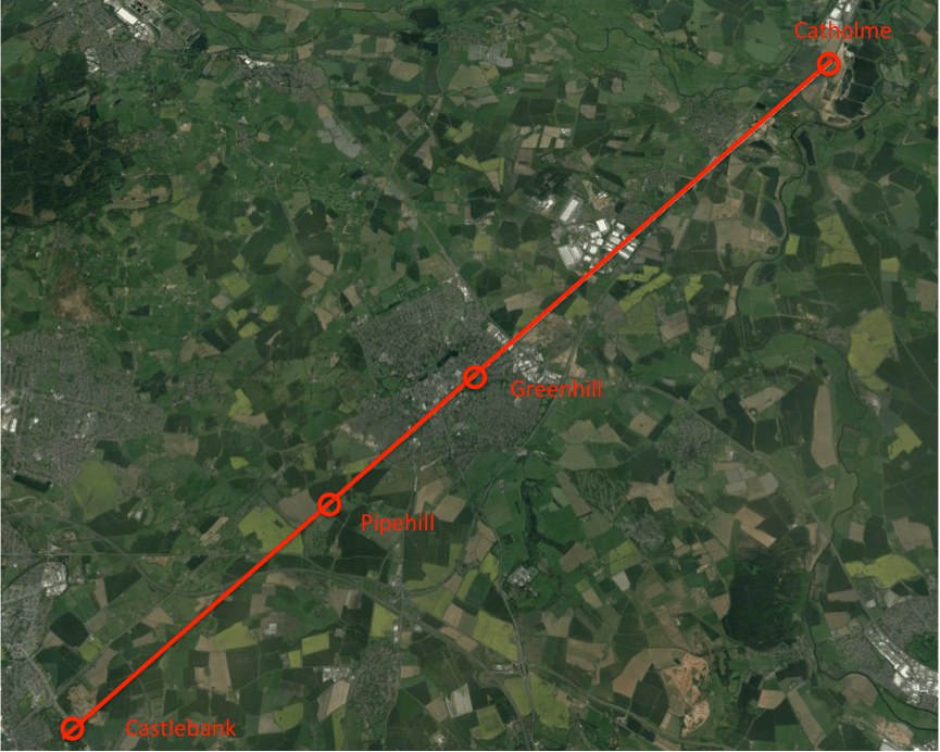
Figure 2 The Catholme – Castlebank alignment
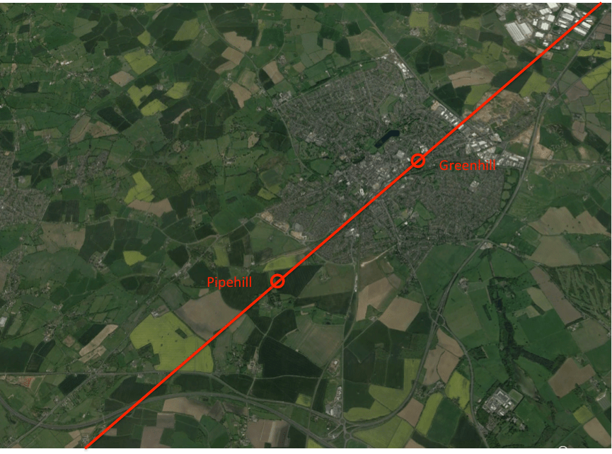
Figure 3 Expansion of the map of figure 2 over the Lichfield area

Figure 4 Elevation profile of the Catholme – Castlebank alignment
Speculations on meaning
Clearly Catholme included solar alignments from its earliest date – the east-west axis of the cursus, with the Sunburst monument on the same alignment, would give two spring / autumn equinox alignments. The Woodhenge monument thus seems to have been positioned to create a midwinter sunset alignment with Castlebanks. What the ultimate purpose of these alignments were is of course impossible to know – they may have been purely for calendar purposes, or may have had a deeper cultic aspect. But from the perspective of a current Lichfield resident, I would like to ask if the Lichfield area were in any way, other than an accidental one, part of this overall scheme?
Now Pryor (2003), based on a study of a wide range of pre-Roman sites, identified the following characteristics that indicate the ritual use of such sites.
- Solar or lunar alignments.
- Rivers, marsh or open water, which has been used for votive offerings of weapons and other utensils, sometimes with causeways in to or across the body of water.
- The proximity of barrows or other burials.
- A distinction between the “domain of the ancestors” identified by “hard” stone monuments, and the “domain of the living” identified by “soft” wooden henges or monuments.
- The usage of the site by many groups or tribes, as a communal meeting point.
Now let us address each of these issues in turn for the Lichfield area.
- Clearly the Lichfield area meets the first of these criteria – as part of the longer Catholme – Castlebank alignment and also with Greenhill and Pipehill being on that alignment and having an internal alignment of their own.
- In terms of rivers and bodies of water, there are clearly springs on both Greenhill and Pipehill, and the centre of Lichfield was likely to be quite swampy at the confluence of the Leamonsley and Trunkfield brooks. Both neolithic and bronze age axeheads have been found in the area, although the precise locations are not known. Such artefacts have been known to be ritually deposited at other sites (Carver, 1981).
- There are a number of prominent barrows in the area, and in particular Offlow to the south, and possibly Borrowcop to the south east.
- There is no archaeological indication of stone monuments from the bronze or iron ages in the Lichfield area, but there is of course the historical association of Greenhill with the rituals of death – the large graveyard at St Michael’s church and the dedication to the Christian “psychopomp”, the collector of souls. But these indications come from 2000 years after the Woodhenge monument was last in use.
- Similarly with regard usage of the site for communal gatherings, Bassett (1981) has shown that in the pre-Roman era, Lichfield was the centre of an extensive trackway system linking a range of communities in the area. But again this reflects a later age.
From this it can be seen that there are perhaps some indications that the Lichfield area fulfils some or all of Pryor’s criteria for a cultic site set out above, including the existence of the solar alignment, and may be of importance as a cultic site from early times. But of course, as with all such speculations, final proof is impossible.
References
Ancient Monuments UK (2019) https://ancientmonuments.uk/115453-hillfort-known-as-the-castle-fort-at-castlebank-plantation-aldridge-north-and-walsall-wood-ward#.Xo8tmi3MxzA
Bassett S (1981) “Medieval Lichfield: a topographic review”, Transactions South Staffordshire Archaeological and Historical Society, XXII, pp 93-121
Carver M G H (1981) “The archaeology of early Lichfield: an inventory and some recent results” Transactions South Staffordshire Archaeological and Historical Society, XXII, pp 1-12
Chapman, H, Hewson, M & Watters, M (2010) “The Catholme Ceremonial Complex, Stafforshire, UK”, Proceedings of the Prehistoric Society, London. 76, 135-163, 10.1017/S0079497X00000487
Pryor F (2003) “Britain BC”, Harper Collins, London
Wood J E (1978) “Sun, moon and standing stones”, OUP

An impressive share! I’ve just forwarded this onto a friend who had been doing a little research on this. And he actually bought me breakfast due to the fact that I found it for him… lol. So allow me to reword this…. Thanks for the meal!! But yeah, thanx for spending some time to discuss this issue here on your web page.
LikeLike