The “Britain from Above” archive contains a huge number of aerial photographs covering the entire country. These are usually arranged in sets of photographs concentrating on a particular notable landmark, and they give a huge amount of detail of the area around the site. Low-resolution photos can be downloaded and used on websites, and a simple free registration allows the reader to zoom in to small parts of the photographs for amazingly detailed views. When a search is made for Kingswinford, two sets of photographs appear – one is a set of six photographs of “Woodfield House and its Environs, Kingswinford, 1939” and the other a set of nine photographs of “Gibbons (Dudley) Ltd Silica Works at Corbyn’s Hall, Kingswinford, 1950”. It is with the second that this blog post is concerned. I will post some of the low-resolution photos taken as the plane flew around the site and label them with information contained on the large scale Ordnance Survey map for the 1950s from Edina Digimap. Taken together they provide us with a glimpse of the Corbyn’s Hall area in the 1950s and also, if one looks carefully, at the neighbouring villages of Kingswinford, Pensnett and Bromley.
Gibbons (Dudley) Ltd
The firm was founded in 1834 by Benjamin Gibbons, who is discussed at length in Kingswinford Manor and Parish, using high-grade fireclay to make bricks. They manufactured refractory products – firebricks, cements, concretes and plastic refractories. The main works was at Dibdale, Lower Gornal with additional works at Cooper’s Bank and Corbyn’s Hall, Pensnett. The Pensnett works was just one of the industrial concerns that grew and prospered on the Corbyn’s Hall estate that came into the ownership of the Gibbons Family in 1780. These included coal mines, iron and steel works and brick works. The map from the 1950s indicates a brick works at the centre of the site, with a number of chimneys, which was presumably the Sillica works, but also a large steel works and numerous disused coal and ironstone pits. In all the photographs that are used, the tallest chimney at the works will be marked by a red cross as a point of reference for the reader.
Looking northeast
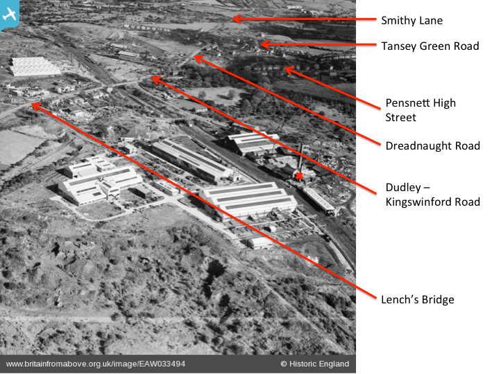

We begin with the view looking northeast over the site, given. Here the relevant photograph is given twice. The first highlights the roads in the area – the Kingswinford-Dudley Road, Dreadnaught Road, Tansey Green Road, Smithy Lane and Pensnett High Street. Lench’s Bridge is also shown. This was built to span the Stourbridge Extension Canal. Little can be seen of this canal by 1950, it having been abandoned several decades earlier, although I will indicate its course in later photographs. The second photograph shows the various industrial concerns in the area, mainly distributed along the Wombourne Branch Railway (at this time still part of the through route for goods trains from Stourbridge to Wolverhampton). Just south of the main road is the site of Pensnett Halt, one of the stops on the short-lived passenger service on the line in the 1920s. On the Corbyn’s Hall site itself the brick works and steel works can be seen, the former being marked by a red cross as mentioned above, together with a number of old colliery workings. On the northern side of the Dudley – Kingswinford Road there are the Dreadnaught tile works and Stourbridge Refactories, both rail connected. The sawmill just to the south of the road has a long history and it can be traced back in census records to the 1880s at least. One of the most obvious features of the photograph, that will be observed on all those that follow, is the large area of waste ground around the site – caused by a century or more of coal and ironstone mining and other industrial use. This area, with all its hidden dangers, was the playground of my youth.
Looking east
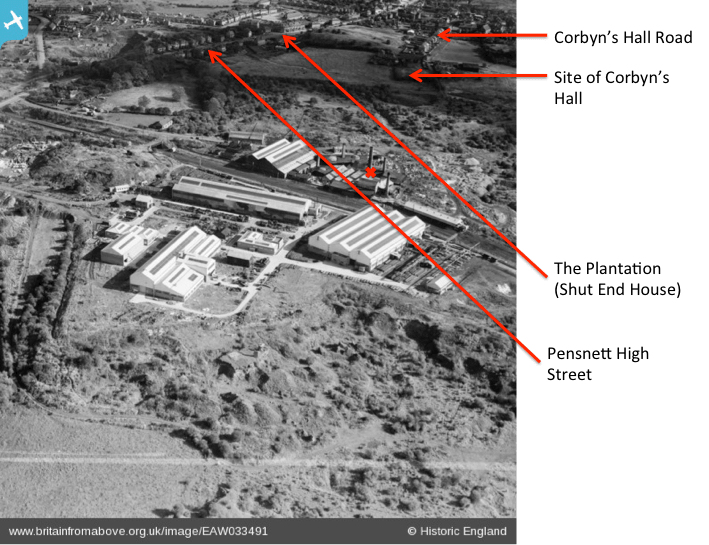
The next photograph shows the view looking east over the site. In the background we can see Pensnett High St, the large house known as the Plantation, which was formerly known as Shut End House, the residence of Ben Gibbons himself. The photo also shows the site of the original Corbyn’s Hall which suffered badly from subsidence due to the mining activities and was demolished in the early years of the twentieth century.
Looking southeast
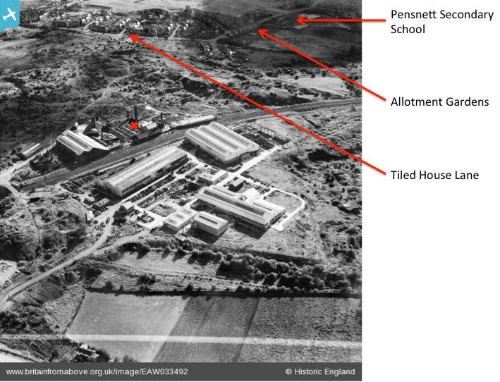
The next photograph swings round further and looks southeast. At the top of the photograph Tiled House Lane and its numerous cul-de-sacs is clearly seen, together with a region of allotments and Pensnett Secondary Modern School. The large area ofwaste land between Tiled House Lane and the works is very obvious.
Looking south

The next photograph looks due south towards Bromley, with Bryce Road, Bromley Iron Works and the disused New Bromley Colliery in the distance. I include on this photograph, and the following two, the line of the abandoned Stourbridge Extension Canal. It can be seen that the steel works is effectively built over the line of the former. The canal had a number of short branches. One of these served the Corbyn’s Hall old iron works which was on the left of the picture, and would have left the main line somewhere under the modern works, and gone under the railway line. The other was the Standhills branch, which left the main line somewhere around the top of the photograph and followed a large loop to the west.
Looking west
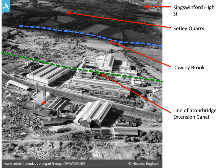
This photograph looks due west towards Kingswinford in the background. I have indicated on it the line of the Stourbridge Extension Canal, and also the line of Dawley Brook. The latter marks the bottom of the steep slope down from Commonside in Pensnett towards Kingswinford. The original Corbyn’s Hall estate extended well to the west of the brook. On the Fowler map of 1822, this brook had a number of pools along its length – which were possibly the remains of mill pools or ornamental features.
Looking northwest
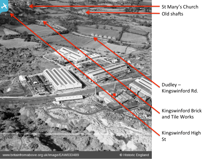

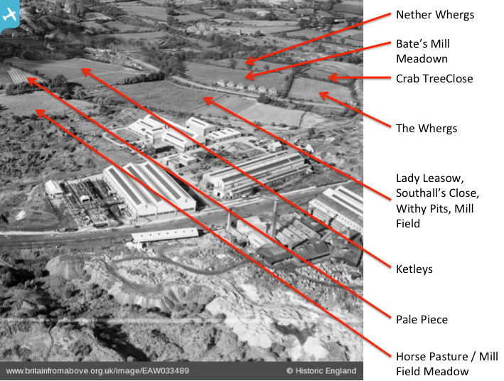
The last photograph, looking northwest, is repeated three times. On the first the Dudley –Kingswinford Road is again labeled, together with the Kingswinford Brick and Tile Works, St Mary’s Church and the old shafts and spoil tips of Shut End Colliery. The second again shows the lines of the Stourbridge Extension Canal (on both sides of Lench’s Bridge) and the Dawley Brook, and also shows the line of the original Kingswinford Railway (of Agenoria fame). The third shows the names of some of the surviving fields. These can be linked back to the 1822 Fowler Map of the area, and also earlier 18thCentury maps of the Corbyn’s Hall Estate. Their essentially rural names speak of a very different age. Some of these names indicate the presence of mills along the Dawley Brook. I find it remarkable that they were able to survive in an identifiable form as late as the 1950s.
More detail
As mentioned above, much more detail can be seen by zooming in on the photos on the Britain from Above site. It is tempting to reproduce screen shots of these views here, but I don’t think this would meet the license conditions. But I would urge interested readers to have a look. The specific views that intrigue me are on the “Looking east” photo, where one can see the large open cast area just west of Tansey Green (close to the old Shut End Methodist Chapel), the Birds Meadow school, and the back of the Independent Methodist Chapel on Commonside (the successor to the Shut End Chapel, and the one I attended as a child); and on the “Looking southeast” photo the close up of houses in Tiled House Lane – including the one where I spent the first 18 years of my life. Do take a look!
Cornyn’s Hall today
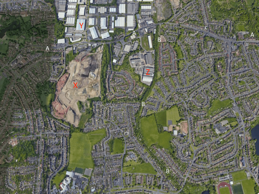
Finally, following a request from Tony Garratt (see comments), the figure below shows the area in 2020 (from Google Earth). I have marked the Kingswinford to Dudley Road (A-A-A) and the Wombourne Branch railway line (B-B-B) for comparison with the other photos. The picture is dominated by Ketley Quarry (X), the Pensnett Trading Estate (Y) and the industrial premises on the part of the site shown in the photos above, to the west of the railway line (Z).

Another great article! Thabk you. What would be nice at the end is to have a current photo of the site.
LikeLike
Another great article! Any chance of a photo of the site as it looks today as a comparison?
LikeLike
Excellent idea. I will prepare something using Google Earth and post it in the next day or so. Watch this space.
LikeLike
Modern map now added at the end of the article. Can anyone identify the current industrial use of the Corbyn’s Hall site – I haven’t physically been down that way for ages.
LikeLike
Hi, I find these articles very interesting, I have lived on The Plantation now for 12 years and I would really like to find a picture of the old house that used to stand here ( Shut End House later The Plantation) also the house that used to stand next door called Ivy Walls. We have a very old wall at the back of our house with a bricked up gateway still will the iron gate hangers in it, please could you find some photos, it would be much appreciated.
LikeLike
Thanks for this. There are a couple of photographs in the book “Britain in old photographs. Brierley Hill” by Stan Hill – see https://www.amazon.co.uk/Britain-Old-Photographs-Brierley-Hill/dp/1840150351. The first shows a picture of the house (built in 1760) and the caption tells of its purchase by Dr H W Plant and his family (hence the name). The second shows a picture of the family outside the front door – including Dr Plant’s son, Arthur, who was my doctor when I was a child. If you send me an email address to the address on my web site, I can send you a photo of the page but I can’t post it here for copyright reasons.
LikeLike
Dear mr Baker, thank you so much, for telling me about the book, I have now purchased it and will soon be able to see the photos of Shut End House. Many thanks, Kath Baker.
LikeLike
Dear Chris Baker, thank you for the info anout the book with the photos in of Shut End House, I have now purchased the book and I am waiting for its arrival. Many thanks Kath Baker.
LikeLike