
The Cathedral Prebends
In this post we will use the information provided on the Lichfield Tithe maps to investigate the nature of the Cathedral prebends. Until quite recently (in historical terms) members of cathedral staff (prebendaries)were supported by the income from various estates (prebends). In the case of Lichfield, there were basically two types of prebend – the first consisting of estates of various sizes that were leased for farming, industrial or residential purposes; and the second consisting of the income from specific ecclesiastical foundations. The system is well described in the Lichfield Cathedral section of the Victoria County History. At the peak of the prebendal system, Lichfield had 32 prebends, most of which were held by clergy who were only required to be in Lichfield for a few months a year. Twenty four these were of the second type, based on the income from various churches in the diocese and eight of the first type based around specific land allocations. It is thought that five of these – the prebends of Freeford, Handsacre, Longdon, Statfold and Weeford were actually the estates that supported the five canons of Lichfield mentioned in the Domedasy book. Since the prebends are named after areas around Lichfield, it seems reasonable to assume that they consisted of specific areas around the city. Now for many of the properties that are listed, the tithe maps give an indication of which prebend they were in in the middle of the nineteenth century, and thus offer the possibility of mapping these prebends in more detail than has been previously possible. In what follows, we will thus attempt to do this, and it will be seen that it offers a description of the Anglo-Saxon geography of the area that is quite distinct from the later geography. It must however be stressed that what the Tithe maps show is the outcome of many hundred years of land sales, exchanges and re-organisations and thus absolute clarity on the original extent of the prebends is not to be expected.
Lichfield from Domesday to the Reformation
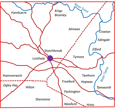
Figure 1. Lichfield and the surrounding area
(blue indicates rivers; solid brown lines indicate early, possibly Iron Age roads and trackways that survived to the present time, and dotted brown lines indicate Roman roads)
Figure 1 above shows the area around Lichfield, with the Rivers Tame and Trent and the early road system identified in the topographical studies of Stephen Bassett, that I have briefly described in an earlier post. The names shown in regular type are the members of the Manor of Lichfield given in Domesday that lie in the vicinity of the city itself, and those in italic type are places that occur in other Domesday entries. It can be seen that the extent of the Manor was large stretching west to Hammerwich and east to the Tame at Tamhorn. There are some obvious gaps on the map – for example around Longdon to the west and Whittington to the east. There are also names not included on the map as their location cannot be identified – Horton, Burweston and Littlebeech. The important thing to observe from the perspective of the current investigation is that the three ancient prebends that are named on the map – Freeford, Hansacre and Weeford have no special importance over the rest. This suggest that if they are basic building blocks of a geography of the area, then this geography significantly predates Domesday and is very old indeed.
The town of Lichfield was set out by Bishop Roger de Clinton around 1140 and became styled as the Manor of Lichfield in its own right, with the rest of the area taking the title of the Manor of Longdon. Over the following centuries many of the members of the Manor became parishes in their own right (as we shall see below) and Lichfield itself shrank to the region of the what were to become the parishes of St Michael’s, St Mary’s and St Chad’s. Within this area there was no parochial system as such, with pastoral care being on the basis of the prebend. The three churches were staffed by the vicars of the five ancient prebends of Freeford, Handsacre, Longdon, Statfold and Weeford. A vicarage was created for St Mary’s with jurisdiction over the city centre in 1491 with the stipend paid from a number of prebends, with the five ancient prebends contributing the majority of the resource. The parishes of St Michael’s and St Chads came into existence in the seventeenth century, although they remained as perpetual curacies until the nineteenth.
Lichfield Parishes
The parishes in the wider area around Lichfield around 1840 are shown in figure 2, drawn with information from The Parish Atlas of England, by Tim Cockin. The three Lichfield parishes can be seen to be of very different sizes, with St Michael’s parish extending a long way to the west at Burntwood, with a detached portion to the east at Fisherwick. St Chads, occupies the northern area of Lichfield, whilst the parish of St Mary and the extra-parochial areas of the Close and the Friary, are very small in comparison. Whilst much of the rest of the area shown in figure 2 is divided into parishes in the normal way, there are a number of extra-parochial areas, often representing areas of former or existing common land such as the Hays at Ogley, Alrewas and Kings Bromley.
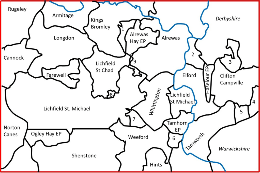
Figure 2. Parishes in the Lichfield area around 1840
(1 – Kings Bromly Hay EP; 2- Croxall; 3- Ingale; 4- Thorpe Constantine; 5 – Statfold, 6- Hopwas Hay EP; 7- Freeford EP; 8 – St Mary’s, Lichfield; The Close EP; The Friary EP; 9 – Detached parts of Farewell)
The immediate area around Lichfield is shown at a somewhat larger scale in figure 3. The individual townships in St Michael’s and St Chad’s parishes are shown. It can be seen that the parish of Farewell and Chorley, to the west of St Chad’s parish has detached portions to the east.
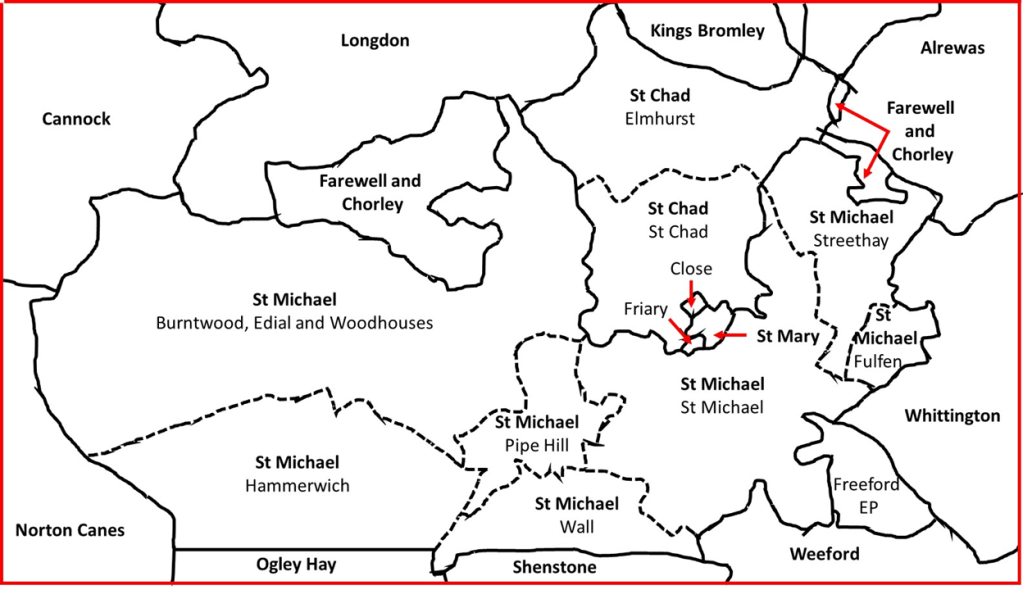
Figure 3. Lichfield parishes and townships
The prebends mapped

Figure 4. Prebends in the Lichfield parishes
(Letters referred to in text; diagonal stripes indicate prebend to which tithe allocated; vertical stripes indicate region with name of prebend; red – Freeford; green – Weeford; blue – Statfold; yellow – Gaia Major)
The tithe maps give details of the tithes payable for each individual property that they list. Where appropriate they also give an indication of which prebend the tithe is allocated to. The information given varies somewhat in form from parish to parish, and thus we will consider each parish in the area around Lichfield below. We begin by considering the Lichfield parishes themselves in figure 4.
- St Michael’s parish, St Michael’s township (A on figure). Here the prebendial split was at its most complex. Figure 4 shows only the regions that can be identified as part of Freeford prebend, which occur across the township, and probably indicates the major underlying land unit. The rest of the area was in the main occupied by land that was allocated to Freeford, Handsacre, Statfold and Weeford jointly, either as part of what is referred to as the Part Pound Tithing, or simply a two or more prebends being allocated tithes jointly. In addition each of these prebends were allocated the tithes from cluster of residential properties close to the city in the Greenhill and St John’s area. There was also a small area where tithes were allocated to the prebends of Bishopshull, Bishops Itchington, Prees and Pipa Minor, but in general the underlying prebend, seems to have been Freeford.
- St Michael’s parish, Burntwood, Edial and Woodhouses, Wall and Pipe Hill townships (B, C, D). Almost uniformly the tithes in this area were allocated to Weeford prebend, again with allocations for small residential areas to the other prebends near the city. The large tract of land to the west is indicated on the tithe map as Burntwood Common and no prebend is indicated.
- St Michael’s parish, Hammerwich township (E) Tithes in this are allocated to the “Appropriator” – the one to whom the rights to the tithes were sold at some point in the past. No prebends are given.
- St Michael’s parish, Streethay township (F). Here the major allocation of tithes is to Statfold prebend (shown on the map), with some small allocations to Bishops Itchington, Curborough and Gaia Minor prebends.
- St Michael’s parish, Fulfen township (G). As with Hammerwich, tithes are allocated to an Appropriator in this region.
- St Chad’s parish, St Chad’s township (H). Here the situation is again complex. There are large allocations to Freeford and Weeford, together with a large allocation to the prebend of Gaia Major in the central area. There are also smaller allocations to the major prebends in the residential areas, and also small allocations to Bishopshull, Curborough, Gaia Minor and Pipa Minor.
- St Chad’s parish, Elmhurst township (I). The tithes of most of the land in this township are allocated to the Mark Part Tithing – jointly between Freeford, Weeford, Handacre, Statfold and Gaia Minor. There are some allocations to Bishopshull, Curborough, Gaia Minor, Handsacre and Pipa Minor prebends in the north.
- Freeford extra parochial area (J). There is no tithe map available for this area, but it has been assumed on figure 4 that the entire area here was allocated to Freeford prebend, which does not seem unreasonable.
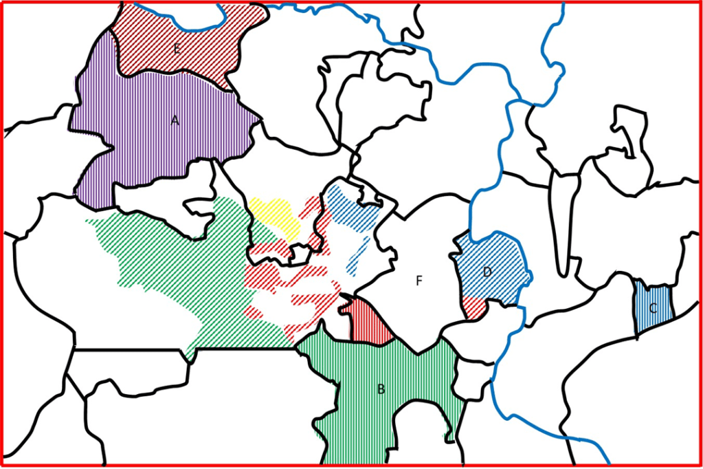
Figure 5. Prebends in the wider area around Lichfield
(Letters referred to in text; diagonal stripes indicate prebend to which tithe allocated; vertical stripes indicate region with name of prebend; red – Freeford; green – Weeford; blue – Statfold; yellow – Gaia Major; purple – Longdon; brown – Handsacre and Armitage)
Figure 5 shows a rather wider area around Lichfield indicating the situation in the surrounding parishes. The parishes of Longdon (A), Weeford (B) and Statfold (C) have tithes allocated to the vicar of the parish, or to an Appropriator, but are here marked as belonging to Longdon, Weeford or Statfold prebend. The outlying pat of St Michael’s parish at Fisherwick (D) has tithes with discrete areas allocated to Statfold and Freeford prebends. The parish of Aldridge and Hansacre (E) has tithes allocated exclusively to the prebend of Handsacre and Armitage, the successor of the ancient prebend of Handsacre. The tithes of the parish of Whittington (F) are allocated to the prebend of Whittington and Berkswell (the latter being in Stafford), which is a relatively modern prebend. All the other parishes shown have tithes that are allocated to the vicar of the parish, or to an Appropriator. At this point it should be noted that there is a minor discrepancy between the tithe maps and material in the Parish Atlas for Farewell parish. On the tithe maps, the lower arm to the east of the parish is shown to be a detached part of Elmhurst township in St Chad’s parish, with its tithes allocated to Pipa Minor prebend, whilst in the latter it is shown as integrated into Farewell, as shown here.
Discussion
So what of the original premise of this post – can the ancient prebends be said to have well defined territories. I would suggest, on the basis of the maps of figures 4 and 5, the answer is a tentative yes. Let us consider each of the ancient prebends in turn.
- The area where the tithes are allocated to Freeford, together with the eponymous hamlet, suggest that the original Freeford estate included most of St Michael’s township and part of St Chad’s and probably the city centre parish of St Mary as well. To the east it included Freeford, part of Whittington, the southern part of Fisherwick and perhaps extended to the river Tame through Tamhorn.
- The territorial extent of Weeford prebend was very large, assuming that the later parish of Weeford was included within it. As well as the parish, it included the eastern part of Brownhills, Edial and Woodhouses township, Pipe Hill township and Wall township, as well as a small part of St Chad’s parish. It also possibly contained the Hammerwich area and the parish of Hints. Figures 4 and 5 suggest that part of Shenstone parish would probably have been included as well in order to make the eastern and western portions more of a coherent whole. If that were the case it would have been centred on Wall, the oldest settlement in the area at the junction of the Roman roads. In total it formed a wide arc around the southern and western edges of the city.
- Statfold prebend extended from Streethay township in the west, through Whittington and the northern part of Fisherwick, and presumably to the parish of Statfold itself in the east. If it formed a coherent connected estate, it would have to have included parts of Elford and Clifton Campville parishes, for which there is no evidence.
- The situation with respect to the two western prebends of Longdon and Handsacre is complex, probably because of the early formation of Longdon parish, and its role as the centre of the manor after the setting out of the town by Bishop Clinton. From figures 4 and 5 it can tentatively be suggested that it included Longdon parish itself, Farewell and Chorley parish, Elmhurst township and perhaps the area in St Chad’s parish allocated to Gaia Major. The latter could as easily be part of Weeford or Freeford prebends.
- Handsacre prebend obviously included the later parish of Armitage and Handsacre in its entirety. If it ever extended closer to the city, it would have needed to include at least part of Kings Bromley parish and perhaps Elmhurst township too. There is no indication that this was ever the case. Geographically the parish boundaries suggest it may once have been associated with Longdon and perhaps represents and early division of the prebends in the Anglo Saxon era.
So what then might be the implications of this study? It points to an early Anglo-Saxon subdivision of the area around Lichfield into a small number of large divisions. One of these, that later bore the name Weeford, was probably centred on Wall and was thus a territory associated with the Roman settlement of Letocetum. Another, Freeford, seems to have embraced the location of the current city centre and extended eastwards a considerable direction. The -ford in Freeford has been taken to refer to the rather inconsequential ford over a brook close to the current Freeford House. If one accepts that Freeford originally encompassed the city centre, then the ford referred to might be the more substantial one that would have crossed the Leomansley Brook in the region of the current Minster pool.
A comparison of the prebend areas with the road system shown in figure 1 is of interest. Basically each of the prebends is connected with the centre of Lichfield via an ancient road – Freeford via the road that is now the Tamworth Rd, Weeford by the London Road and the Roman road network, Longdon by the Stafford Road and Hansacre by the road to Rugely. Statfold is connected by the road that enters the city via Darnford Lane and Boley Cottagee lane. If this extended all the way to Statfold, its route east of Whittington is however not clear. The prebends thus form a well-connected network with easy access to the central area.
I have argued elsewhere, based in the main on place name studies, that the Lichfield area was a centre of pre-Christian pagan worship, and that the ancient prebends played a significant role in this. The current work does nothing to counter such a proposal, and perhaps, by showing the extent of the prebends tends to confirm it.

2 thoughts on “A study of the ancient prebends of Lichfield Cathedral”