This post contains edited extracts from Kingswinford Manor and Parish, which gives full details of background sources etc.
The Tiled House Estate sat to the south of the Corbyn’s Hall estate, extending from Commonside in the east to the Standhills area in the west and Bromley Lane, the Bromley House estate and the hamlet of Bromley to the south. I speculate in KMAP that it may originally have been associated with the Corbyn’s Hall estate as part of the early enclosure of Pensnett Chase in the area. Against this is the evidence of the 1840 tithe map which gives a clear distinction between the Corbyn’s Hall estate, which was formally tithe free, and the rest of the land in the area on which tithes were levied. Whatever its origins, by the late 17th century, it was an established estate, based around the building that was known as the Tiled House – presumably because of its novel roofing material.
We first read of the Tiled House in 1688 when John Heydon made steel there using a novel process that involved the importation of Swedish Coal. Thus it seems to have been a place of industry from its earliest days. At some point in the 18th century it was occupied by Waldron Hill, father of John Hill who built the Wordsley Flint Glass House. During the latter part of the that century it was owned by the Mee family, and in 1760 Patience Mee, the widow of John Mee, leased it to Thomas Brettell. He was still in occupation in 1800. At this point the affairs of the estate become very complex, and one can do no better than quote the words of an exasperated cataloguer at Dudley Archives who writes the following in one of the most eloquent archivist entries that the author has had the pleasure to read.
A full description of the legal and equitable nightmare surrounding this estate between the 1790s and the 1840s is impossible. Many of the deeds are wanting. Suffice to say that a mother buys in the life interest of her bankrupt son and, in effect transfers it to his children, but leaves other actual and potential interests to be inherited by those grandchildren and her other children; the actual estates taken are the subject of litigation, particularly in respect of her eldest grandchild, Richard Mee like his father, who predeceases his father and leaves an infant daughter as his heir, whose husband eventually buys out most (all?) of the other interests and settles the outstanding charges on the estate. Other bankruptcies, insolvencies and imprisonments for debt just muddy the waters.
A court case of 1830 explains a little more. Patience Mee left the estate in the hands of trustees, with instructions to give her son Richard up to £50 a year from the proceeds (and no more!). The rest of the estate was to be used to provide for the education and upbringing of Richard’s three children, Richard, Sarah and John, during the life of Richard the elder. In 1830, Richard the elder was still alive, but John was the only one of the grandchildren still living, and although he was over 21, was arguing that because his father was still alive he was still entitled to support from the estate. He won his case. Much detailed work is required to elucidate the complexities of the situation.
The Fowler maps of Kingswinford enable the boundaries of the estate to be drawn, and these are shown from the 1822 map in the figure below. There was little difference between the 1822 and 1840. Indeed, the plan produced for the unsuccessful sales of the estate in 1817 and 1825 show very similar boundaries. The particulars of the estate from the attempted sale of 1825 are included below, and illustrate the extent and nature of the property (and give an indication of how houses and lands were sold in the early 19th century.
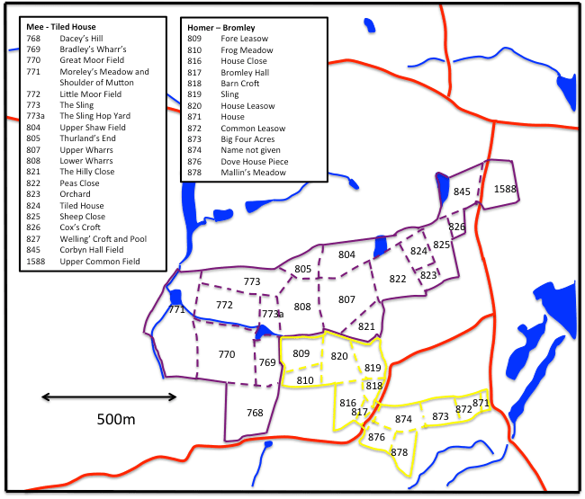
In 1822 the entire estate was stilled owned by the impecunious Richard Mee, and Thomas Brettell was still in residence. In 1833 and 1838, the elector’s lists indicate that it was occupied by John Dudley, who was a partner of the Iron Works on the Corbyn’s Hall estate. In 1840 the estate was in the hands of Trustees, Richard Mee having died some years previously. It is not clear who purchased the Tiled House Estate from the Trustees of Richard Mee, but certainly by the late 1830s William Matthews was in residence, and clearly came to own the estate at some point in the years that followed. Matthews died in 1871 and his estate passed to his son, Benjamin St John Matthews. However, William Matthews’ actual residence at the Tiled House was brief, and in the 1841 and 1851 census it is recorded as being occupied by Charles Woodcock, a Coalmaster. From sometime before 1861 till after 1891, the house was occupied by the family of William and Letticia Barlow. Barlow was a corn merchant and one of the founders of the New Connexion Chapel in Chapel St and remained an active member of that church and a Sunday School Superintendent for many years.
As with the neighbouring Corby’s Hall estate, the Tiled House estate gradually became more and more industrialised. Indeed, it would seem that both estates were operated as a unity, particularly during the ownership of William Matthews – see the earlier posts describing the Corbyn’s Hall estate, the mining activities in the area, and the development of the transport network.
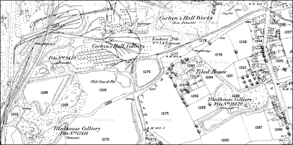
The later development of the area can be seen in the large-scale Ordnance Survey maps. In 1882, what was to become Tiled House Lane was in formation, with the lane from Commonside down to the Tiled House itself being joined by Rookery Lane, now the bottom end of Tiled Hose Lane coming from Bromley. A long railway siding ran parallel to the lane on the Corbyn’s Hall side. This line had quite a fearsome gradient of 1 in 25, and it seems to me likely it was used to deliver coal to the Corbyn’s Hall works, with the trucks being lowered from the top of the incline by gravity and the empties being pulled back up by horses. The present site of Mullet Park was Tiled House Colliery Pits Number 19 and 20 (disused) and between Rookery Lane and the GWR railway line, there were Pits 17 and 18 (disused). At the top of the lane at the junction with Commonside there was a Brick Works. This being said, a number of the fields shown in the figure above were still in use for arable purposes.

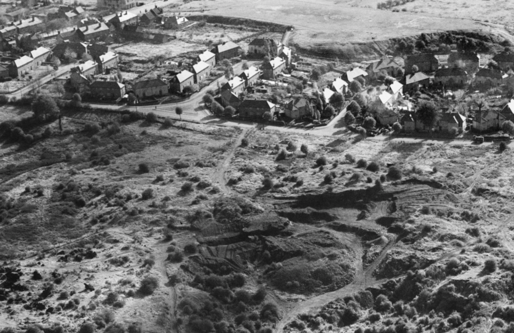
The situation had changed little by the time of the 1910 map, but by the time of the 1930 map shown above, the current Tiled House Estate had been built, together with the school near the Bromley end of the lane. Tiled House Colliery pits 19 and 20 had been replaced by Mullet Park, and large areas of dereliction can be seen to the north of Tiled House Lane in the Corbyn’s Hall area. This area is shown in the clip from a 1950s aerial photograph of Corbyn’s Hall shown below. This photograph is taken from over Corbyn’s Hall looking south over the upper end of Tiled House Lane, with Mullet Park in the background. The old industrial area north of Tiled House Lane is in the foreground. And here things become personal. I was brought up in Tiled House Lane in one of the houses shown in the picture, and Mullet Park and the broken ground to the north of the Lane were my childhood playgrounds. They bore little relationship to the agricultural estate of Richard Mee in the 1950s – and even less today!
Transcript of Tiled House Estate Sale Particulars – 1825
TO be SOLD by AUCTION by BUNCH and JOHNSON at the Dudley’s Arms Inn, In Dudley, on Wednesday the 30th day of March, 1825, at 12o’clock at noon, in the following or such other lots as shall be agreed upon, and subject to such conditions as shall be produced at the time of sale:-
LOT 1. All that capital Messuage or Mansion House, with the malthouse, barns, stables, coach-house, granary, cowsheds and other outbuildings, fold-yard, plantations, garden and orchard thereto belonging, called the TILED HOUSE, situate in the said parish of Kingswinford and county of Stafford; together with the several closes or pieces of Land thereto adjoining, and occupied therewith, and containing the quantities following:-
| A. | R. | P. | |
| House, Yards, Gardens, Orchard, Plantation and Rick-Yard | 5 | 1 | 11 |
| Upper Leasow, or Sheep Close | 4 | 1 | 15 |
| Lawn, Welling Croft and Pool | 8 | 1 | 3 |
| Upper Shaw’s Field, including Road | 5 | 3 | 31 |
| Thurland’s End, including Road | 2 | 3 | 39 |
| Upper Wharrs | 8 | 3 | 1 |
| The Hilly Close | 3 | 0 | 39 |
| Lower Wharrs | 6 | 1 | 36 |
| 45 | 1 | 15 |
LOT 2. All those five closes of Land, adjoining together, and also adjoining the last lot, and fronting up to Bromley Lane, called by the names and containing the quantities following.
| A. | R. | P. | |
| Dacey’s Hil | 8 | 0 | 8 |
| Bradley’s Wharrs | 2 | 2 | 23 |
| Great Moor Field | 9 | 3 | 38 |
| Sling Hop-yard | 2 | 1 | 39 |
| Little Moor Field | 6 | 2 | 25 |
| Sling | 7 | 0 | 12 |
| 36 | 3 | 24 |
LOT 3. A capital Meadow, adjoining the last lot, and communicating with the lane called the Greenlane, and called by the name of Moseley Meadow or Shoulder of Mutton Piece, and containing 12A. 1R. 25P.
LOT 4. A plot of Land, part of a close of land called Corbyn’s Hall Field, fronting the public highway leading from Shut End to Brockmore, containing in front 74 yards, and in the whole three roods and six perches.
LOT 5. Another plot of Land, also part of Corbyn’s Hall Field aforesaid, adjoining the last lot and fronting to the said public highway, containing in front 60 yards, and in the whole 3 roods and 18 perches.
LOT 6. Another plot of Land, also part of Corbyn’s Hall Field aforesaid, adjoining the last lot, and fronting the said public highway and also a private road leading to the Tiled House, containing in front next the said highway 38 yards, and next the said private road 80 yards, and in the whole 3 roods and 6 perches.
LOT 7. Another plot of Land, adjoin to the three last lots at the back part thereof, and also adjoining to the said private road, being other part of Corbyn’s Hall Field, containing in front, next the said private road 92 yards, and in the whole 2A. 2R. 8P. or thereabouts.
LOT 8. Another plot of LAND, part of a close called Tiled House Green, or Cox’s Croft, fronting the said private road, and containing in front 37 yards, and in the whole 2R. 23P.
LOT 9. Another plot of Land, other part of the said close called the Tiled House Green, or Cox’s Croft, also fronting the said private road, and containing also in front 37 yards, and in the whole 2R. 23P.
LOT 10. Another plot of Land, part of a close called the Upper Common Field, adjoining the last lot, and also fronting the said public highway, containing in front 67 yards, and in the whole 1A. 1R. 37P.
LOT 11. Another plot of Land, also taken out of the said Upper Common Field, adjoining the last lot, and also fronting the said public highway leading from Shut En to Brockmore, containing in front 67 yards, and in the whole 1A. 3R. 5P.
LOT 12. Another plot of Land, also taken out of the said Upper Common Field, adjoining the last lot, and fronting to the said public highway, containing in front 67 yards, and in the whole 1A. 2R. 21P.
LOT 13. Another plot of Land, adjoining the last lot, taken out of a close of land called Lower Common Field, and also fronting up to the said public highway, and also to an intended road 10 yards wide, and containing in front next to the said highway 69 yards, and next to the said intended road 94 yards, and in the whole 1A. 0R. 13P.
LOT 14. Another plot of Land, adjoining the last lot, also taken out of the said close called Lower Common Field, and fronting the said intended road, containing in front 94 yards, and in the whole 1A. 0R. 13P.
LOT 15. Another plot of Land, opposite to the last lot, also taken out of the said close called Lower Common Field, and fronting the said intended road, containing in front 72 yards and a half, and in the whole 1A. 1R. 33P.
LOT 16. Another plot of Land, adjoining the last lot, also taken out of the said close called Lower Common Field, containing in front 72 yards and a half, and in the whole 1A. 1R. 33P.
LOT 17. Two Dwelling Houses, with brewhouse, shops and gardens, fronting the said highway, and also the said private road leading to Tiled House,containing 1R. 20P. including the site of the buildings.
All the above lots are in the occupation of Thomas Brettell, Esq. of his under tenants.
The Mansion House is very roomy and commodious, and substantially built, and the out-offices and farming buildings are very extensive and convenient, and all the buildings are in good repair.
The whole of the Estate is freehold of inheritance, is in the parish of Kingswinford, and is distant about two miles from Dudley and four from Stourbridge.
Lots 4, 5, 6, 7, 8, 9 10,11, 12, 13, 14, 15, and 16 are staked out, and the whole may be viewed by application to Thomas Brettell, Esq. upon the premises.
Further particulars may be known by applying to Mr. Badham, Solicitor, Bromyard: to the Auctioneers, or at the office of Messrs, Bourne and Sons in Dudley, where maps of the Estate as marked out in lots may be seen.

2 thoughts on “The Tiled House Estate”