
This post contains edited extracts from Kingswinford Manor and Parish, which gives full details of background sources etc.
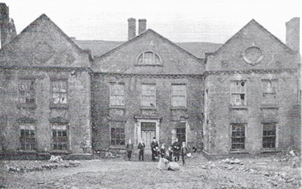
Corbyn’s Hall in the late 19th century
The Estate up to 1780
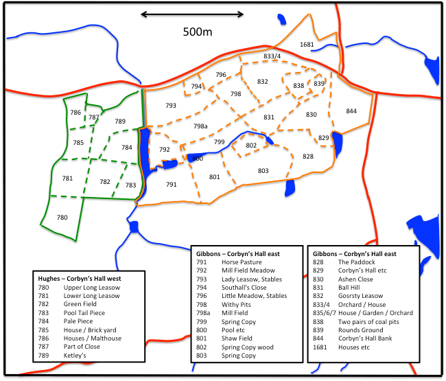
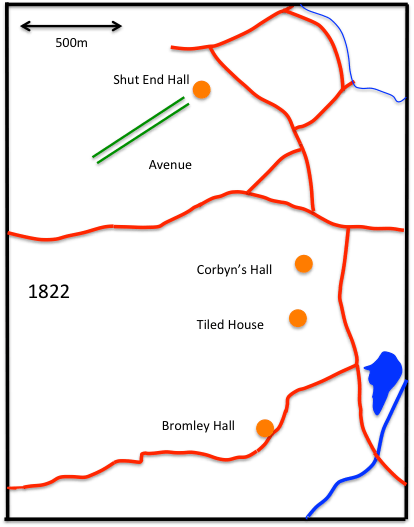
I have described the Corbyn family in an earlier post here. They occupied a large parcel of land in the centre of the manor of Kingswinford, that may have originally been allocated by John de Sutton II, 1st Baron Sutton of Dudley, to William Corbyn on his marriage to the former’s daughter Felicia de Sutton around 1350. On this land they constructed the large house that became known as Corbyn’s Hall. The extent of these lands doesn’t become clear however until the Corbyn family sold the estate to John Hodgetts in 1680. Two early maps exist – from 1703 and 1754 which show estate boundaries very similar to those of the Fowler Map of 1822, shown in the figure below. The map shows the Kingswinford to Dudley Road running from east to west, with the junctions with Tansey Green and Commonside to the east of the area, The estate occupied a large parcel of land that extended south of the Kingswinford – Dudley Road to what was to become Tiled House Lane, and from Commonside in the east to the Standhills area in the west. It sloped quite steeply from the east down to the valley of the Dawley Brook. The brook and its feeders seem to have been landscaped into a series of pools. The land then rose again towards Standhills. The maps also give the field names from 1822. Small changes occurred in these names from the earlier maps also, with corruptions / changes creeping in as the names were passed from generation to generation – for example Mansell’s Meadow in 1704 and 1754 (then in the Corbyn’s Hall Estate) has become two fields in the Tiled House Estate in 1822 – Moreley’s Meadow and Shoulder of Mutton, the latter name being descriptive of the shape of the field. The different colours of the field indicate the two different owners of the estate in 1822 – William Hughes to the west of Dawley Brook and the Gibbons brothers to the east.
The Corbyn’s Hall estate from the 1822 Fowler Map
The Gibbons era – 1780 to 1840
The Gibbons family were originally from the Sedgley area, and developed a significant banking and industrial concern in Bristol, Kingswinford and Wolverhampton by the late 18th century, headed by the three brothers – Thomas (1730-1813), William (1732-1807) and Benjamin (1735-1832). In 1779, the family purchased the Corbyns Hall estate, which included Shut End House. In 1814 Benjamin made over the Level furnaces and other industrial plant to his nephews – John (1777-1851), Benjamin (1783-1873) and Thomas (1787-1829) in return for an annuity and ownership of the Corbyn’s Hall Estate. The three younger Gibbons brothers were declared bankrupt as bankers in 1816, in the slump following the Napoleonic Wars, pulling the iron business down with them. Fortunately, the elder Benjamin, as a preferential creditor, was able to take control of some of the iron and coal interests and save the family firm from total ruin. The younger Gibbons brothers continued to develop the Corbyn’s Hall Collieries and Blast Furnaces, which were built by them about 1824. The Gibbons brothers were major innovators in terms of iron production, and the hydraulic lift at Corbyn’s Hall furnaces could raise around 500 tonnes of raw material a day to the top of the furnaces. The Book of Reference for the 1822 Fowler map lists Benjamin as proprietor, but many of the fields were rented to others. There is a reference to two pairs of coal pits, machine office, engine, tool house etc., in a field to the south of Shut End House. Corbyn’s Hall was occupied by Michael Grazebrook, who also leased a number of the surrounding fields. Benjamin senior (1735-1832) occupied a house on Commonside, whilst the younger Benjamin (1783-1873) occupied Shut End House.
The elder Benjamin died in 1832. In the 1830s the Electoral Registers indicate that the younger Benjamin and brother John were living at Corbyn’s Hall. In 1833 Shut End House was occupied by Henry Bradley, the business partner of James Foster of Shut End. In 1838 much of the estate was leased to William Mathews and John Dudley, ironmasters, for a period of 63 years to 1901. Benjamin however continued to live in Corbyn’s Hall and is recorded as being there in the Book of Reference for the 1840 Fowlers Map and the 1841 census. The 1840 Fowler map shows considerable changes to the estate, with the Stourbridge Extension Canal dividing it in two, with a branch from the canal serving the Corbyn’s Hall furnaces. That Book of Reference indicates that by then, whist the estate was still owned by the Gibbons, it was almost fully leased to Matthews, Dudley and Co. The Corbyn’s Hall furnaces are listed, as are three coal plus three (iron) stone pits etc., and the mines to the south of Shut End House are also referred to. A William Gibbons, Benjamin and John’s cousin, is recorded as living at Shut End House. A portrait of Benjamin from the 1860s is shown below.
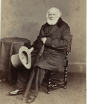
Benjamin Gibbons (1783-1873) in the 1860s (National Portrait Gallery)
During the Gibbons time at Corbyn’s Hall, there were major developments in the transport infrastructure in the area. The figure below shows three large scale scale maps of the region, that show the transport links on the 1822 Fowler map, the 1832 Ordnance survey map (the original of which was at 1 inch to the mile) and the 1840 Fowler map. In 1822 this area was ill-served by transport links, and industry was clustered around the Stourbridge Canal main line and its Fens Branch and thus to improve the accessibility of this area, Lord Dudley and James Foster of Foster Rastrick and Co. opened the Kingswinford Railway in 1829. This ran from a new basin at Ashwood on the Staffordshire and Worcestershire canal, up a 1:28 incline to a level section from the top of the incline to just north of Kingswinford village. From there it ran up another inclined plane with a gradient of 1:29, known as Foster’s incline (A) to a final level stretch in the Corbyn’s Hall area (B). The railway carried coal traffic from a number of mines along its route, and pig iron and iron products from the works of John Bradley and Co. (owned by James Foster) at Shut End (C). It also probably carried limestone from outside the area to the works. It is perhaps best known for its main means of motive power – the locomotive Agenoria, which was built by Foster Rastrick. A fuller discussion of coal mining activity in the area is given in another post here.
There can also be seen to be an extensive series of tramways in the area, almost certainly worked by horse-power, man-power and, where possible, gravity. The major tramway ran from north of the Kingswinford Railway (D), which it seems to have predated as the latter crossed it via a bridge, through Corbyn’s Hall Iron Works (E), where there were a number of loops and branches, and then on through Bromley to a wharf on the Fens Branch of the Stourbridge Canal (F). This tramway was owned by the Gibbons and was used to take coal and iron from their mines and works on the Corbyn’s Hall estates. This involved some sizeable cuttings to keep its gradient constant and a tunnel beneath what is now Bromley High Street. The second tramway ran from the top of Foster’s incline (G) into the Shut End works (C) (see below), whilst a third ran from Lord Dudley’s mines in Shut End (H) to another wharf on the Fens branch (I). Finally, there was a shorter tramway from south of Bromley (J) to a third wharf on the Fens branch, some way to the west of the others (K).
By 1840 the Stourbridge Extension Canal had been built in close association with the Stourbridge Canal Company – indeed half of the members of the Extension Canal Committee were also on the corresponding committee of the Stourbridge Canal. The major shareholder were Sir Stephen Glynne, resident in north Wales and the owner of Oak Farm Iron and Brick works, James Foster, owner of the Shut End works and Francis Rufford, a clay merchant. The canal ran from a junction on the Fens branch to Oak Farm, just off the top of the map of Figure 3.2c where it served the Oak Farm works and the Shut End works. There was a short branch into Corbyn’s Hall (L) that removed the need for the tramway system. Indeed, the main tramway, from Corbyn’s Hall to Bromley, was purchased by the Extension Canal Company under the terms of the Extension Canal Act. As far as can be ascertained from the 1840 map, this tramway was by then in a fragmentary state (M), although the long stretch through Bromley to the Fens branch still existed. The other tramways outlined above were also still in existence, with some extra branches and quite possibly some route changes. It can thus be seen that, even within the two decades between the Fowler maps a complex tramway system was developed and discarded in the Corbyn’s Hall estate. Without the use of the interim 1832 OS map, this would not have been picked out. Another Extension canal branch left the main line and ran to the Standhills House area (N). In the 1840 Reference this is referred to as the new branch and there is no evidence for industry in this region in 1840. It seems likely that this branch was built as a precursor to the opening of mines in the area.
(a) 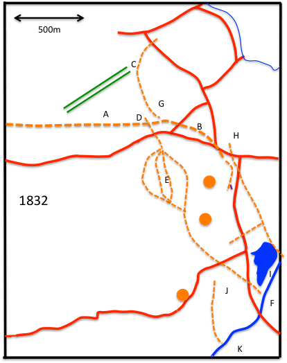
(b) 
(c)
Development of Canals, Railways and Tramways in the Shut End and Bromley areas
William Matthews
As noted above, from 1838 much of the land and the industrial concerns at Corbyn’s Hall had been leased to William Mathews and John Dudley, ironmasters, for a period of 63 years to 1901. William Matthews was born in Hagley in 1796 and in his obituary from 1871 we read the following.
He acquired a minute knowledge of all the practical details and the successive improvements in the manufacture of pig, iron from the South Staffordshire ores, as well as a very extensive acquaintance with everything relating to the iron and coal trades of that district; and was constantly consulted upon all matters affecting these interests. He took an active part in the promotion of various railways in the district, especially the Oxford Worcester and Wolverhampton Railway, of which as well as of the South Wales Railway he was a director..
In 1860 he read a paper to the Institution of Mechanical Engineers on the South Staffordshire Coalfield, with particular reference to Corbyn’s Hall. It is clear from that paper, that he was much more than a simple entrepreneur, but rather he possessed deep knowledge of the nature of the coalfield and the working methods – and was able to write about them fluently and lucidly. A copy of one of the figures from that paper, showing the fractured nature of the seams below Corbyn’s Hall, is given below, and gives some indication of the difficulties that would have been involved in extracting the coal.
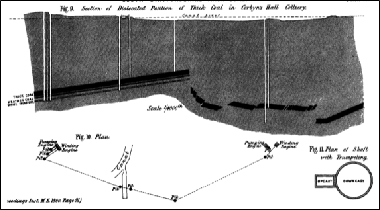
Section through Corbyn’s Hall showing coal seams from Matthews(1860)
In 1842, Matthews and Dudley seem to have bought at least part of the Estate themselves for a sum of £9995. The Matthews / Dudley partnership was dissolved by mutual agreement in 1846, and the estate passed fully into the hands of William Matthews. John Dudley (1807-1861) was a member of the Tipton Dudley family. He was a grandson of Thomas Dudley who was the last resident of Shut End Hall. It seems that he emigrated to New Zealand and the breakup of the partnership with Matthews night have been to facilitate this move.
From then on, for the next 50 years, the lease of the Corbyn’s Hall estate was held by a number of industrialists. These are given in outline in the Table below – taken from Graces Guide for Corbyn’s Hall. The plan with the lease of 1847 is interesting in that it shows the land that has been spoiled by industrial activities – and indicates that any holder of the lease would be required to make it good. These intentions never seem to have been acted on. The regularity with which the lease changed hands would suggest an inherent lack of profitability.
The most notable event to occur during that period was the major boiler explosion in 1862. The Chelmsford Chronicle gives the following account.
A fearful boiler explosion occurred at about six o’clock on the 27th ult. at the Corbyn’s Hall Malleable Iron Works (Messrs. Blackwell and Sparrow), situated about two miles from Dudley, which resulted in the death of four men and serious injuries to about ten others. The exploded boiler was about 30 horsepower and was heated by the flues of the puddling furnaces. At six o’clock number of men were at work in the puddling furnaces, when a fearful explosion took place. The roof of the furnaces was immediately broken through by a mass of falling debris, and the whole place presented a scene of wreck. The bodies of four men were speedily found in the debris, all of them being employed at the works. Ten or twelve others were found to be seriously injured, some of them so seriously that no hopes are entertained of their recovery. The cause of the explosion at present remains a mystery.
The inquest revealed that the boiler had run out of water before the explosion. Those who died were Thomas and George Hudley, Daniel Mason and Ezekiel Newnman (puddlers), Joseph Harper (a fireman) and Morris Christopher, a labourer. The person in charge, Mark Simpson, was absent from the building when the accident occurred, which seems to have not been an unusual occurrence. He was duly charged by the coroner with manslaughter and tried at Stafford Assizes, but the charges could not be proved, and the judge ordered the jury to acquit him.
| 1847 | Lease by William Mathews of Edgbaston esquire to William Malins of Mansion House Place, London and George and Charles Rawlinson of Newton Nottage, Glamorgan, iron and coalmasters, of the Corbyn’s Hall estate, 4 blast furnaces with foundaries, casting houses and related buildings (with specified reservations), and thick coal/ten yard coal, heathen coal and brooch coal, and ironstone, etc., etc. plus other adjacent lands and minerals (specified), for a term of 56 years |
| 1849 | Corbyn’s Hall and Tiled House estates offered for lease (to 1901 and 1863) |
| 1853 | Lease to Samuel Holden Blackwell of Dudley of a mill, forge and premises |
| 1853 | Lease by the Trustees of the will of William Hughes of Kingswinford, gentleman, to William Mathews of Edgbaston and George Hickman Bond of Tiled House, parish of Kingswinford, coalmasters and co-partners, of coal and ironstone under the Ketley Estate for a term of 14 years |
| 1862 | Lease of mill and forge to Henry Sparrow of Woodfield House, Wordsley for 6 years |
| 1867 | Lease to Paul Robinson of Sedgley, Staffs., coalmaster, Gabriel Jones of Kingswinford, coalmaster, George Glaze of Brockmoor, parish of Kingswinford, ironfounder & Daniel Parsons of Pensnett, same parish, engineer, of mines under Tiled House Estate |
| 1868 | Agreement with Samuel Hingley of Cradley, Staffs., ironmaster for an annual tenancy of the Corbyn’s Hall Estate, with plan and detailed schedule of buildings, fixtures and machinery |
| 1869 | Agreement with Hingley for renting number 1 Blast Furnace |
| 1870 | Lease to Hingley of ironworks at Corbyn’s Hall for 7 years |
| 1872 | Lease to Benjamin Williams, Benjamin Williams the younger and George Williams, all of Kingswinford, iron manufacturers, of the ironworks at Corbyn’s Hall, for 7 years |
| 1903 | Sale to Caleb William Roberts of Stourbridge, Worcs., colliery proprietor, of the Tiled House and Common Side Estates, parish of Kingswinford and mines under 97a of land there |
Leases of Corbyn’s Hall and associated estates
The Corbyn’s Hall Iron Works.
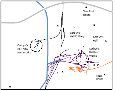
GWR and Pensnett Railways are indicated by black and brown lines respectively, and the Corbyn’s Hall railway by purple lines. Old mine shafts are shown as open circles, and the major residential properties as filled triangles.
By the time of the next major mapping of the area for the 1882 Ordnace Survey map, Corbyn’s Hall had an internal railway network for the transportation of coal and iron products to and from the canals and other railways that surrounded it. The situation in 1882 is shown in the figure below. It can be seen that there are two iron works. The original one was to the east of the Canal, near to Corbyn’s Hall itself, and is marked on the 1882 map as disused, but was clearly still in situ. The new works was to the west of the canal, so we probably here have a picture of the transitional situation. The map also shows the major residential properties of Corbyn’s Hall itself, by this time becoming increasingly derelict; the Tiled House and Shut End House. Many disused collieries can also be seen, from where the original raw material was obtained in the 1820s and 1830s. The Corbyn’s Hall railway itself is a complex set of interlinked lines serving the immediate needs of the old works and providing connections to the Corbyn’s Hall branch of the Stourbridge Extension canal and the GWR Kingswinford Branch. The Tiled House branch of the Pensnett Railway (in brown) can be seen in the bottom right of the figure, ending in a set of sidings. The gradient of this branch is severe, at about 1 in 25, and there is no indication of an engine house anywhere that could provide motive power for hauling full trucks up the branch. It thus seems sensible to regard this branch as being to supply the needs of the Iron Works for coal and ironstone, rather than taking away finished products, with trucks descending the branch by gravity (but with brakes!) and empty trucks being hauled up the branch by horses. It can also be seen that the Corbyn’s Hall railway provides a somewhat convoluted connection between the Pensnett Railway and the GWR in this region.
After the estate was leased by Matthews and Dudley, both the 1840 Fowler Directory and 1841 census indicates that Benjamin Gibbons continued to live at Corbyn’s Hall and his cousin William and his family in Shut End House . By 1851, the situation had reversed with Benjamin living at Shut End House with a solitary housekeeper, and William’s widow and family living in Corbyn’s Hall itself. By 1861, Shut End House only has a housekeeper present and Benjamin is living near Stourport. He was later to move to the Leasows in Birmingham and then to Halesowen where he died in 1873.
After the Gibbons moved out, Corbyn’s Hall then found a variety of uses. In 1861 it was occupied by M. H de Summercourt (originally from Paris) and his family, the Manager of the Ironworks. By that time a considerable community, presumably of estate workers had come into existence around Corbyn’s Hall, and the new Corbyn’s Hall St and Corbyn’s Hall Lane are recorded in the census. In 1871 the occupation is not clear, as the hall was not specifically identified in the census returns. In 1881 there was again record of a community of sorts around the Hall with a set of houses called Corbyn’s Hall cottages, and the offices of the old Corbyn’s Hall Ironworks (to the east of the canal) were also used as a family residence. Corbyn’s Hall itself was occupied by the families of John Wilkinson, a timber merchant, and David Greenway, a coalminer. In 1891, it seems to have been subdivided still further. Corbyn’s Hall cottages still existed, but there was also a Corbyn’s Hall Villa and an Old Corbyn’s Hall. John Wilkinson and his extended family and servants lived in Old Corbyn’s Hall, whilst at Corbyn’s Hall villa we find Thomas Brown and his family, an Inland Revenue Officer. There thus seems to have been an effort to make as much accommodation as possible, with the old house now providing for the local professional class. Around this time the house became increasingly derelict (see the picture at the top of the post) and was eventually demolished in the early twentieth century.
In the twentieth century, the Corbyn’s Hall area retained some industrial activity (as indeed it does to this day) but became largely residential in nature. A discussion of some aerial photographs of the area taken in the 1950s, is given in another post.

What are the names of industries, contaminants, and pathways of historic land use of Corbyn’s Hall furnace of 1840?
LikeLike
I don’t know to be honest. Most of the activity was in iron and steel and related industries, so the main waste product was probably slag, but there were probably other chemical contaminants too – much the same as in large areas of the Black Country. From personal experience as a child in the area, there were large areas of waste in the 1950s and 1960s – see the aerial photos at https://profchrisbaker.com/2020/04/01/corbyns-hall-from-above/ . Presumably there was at least a minimum degree of clean up when the new estates were built – I guess there might be some records of them held by the Council. But I really don’t know anything specific.
LikeLike