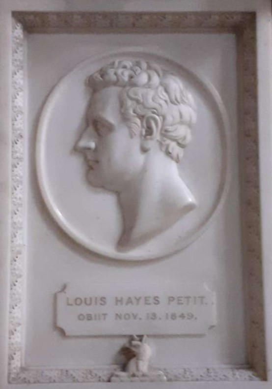
The Black Country pictures of John Louis Petit

Preamble

The landscape artist and architectural critic John Louis Petit (1802-1868) painted a small number of scenes of Black Country activity during his career. In this post I look at two of them, one depicting mines at Wolverhampton, and the other the Spring Vale Furnaces at Bilston. I do not consider their artistic merits – indeed I would be quite incapable of doing so – but rather I will discuss the scenes the paintings portray and the locations from which they might have been painted.

Mines at Wolverhampton

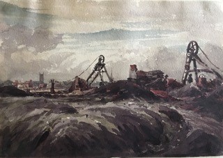
The picture Mines at Wolverhampton is shown above and is reproduced by permission of the Petit Society. On the Petit Society website, it is captioned

c1830-35, 15x20cm, watercolour on paper, private collection.

The main feature of the painting is the pair of pits showing the scaffoldings of the “Rattle Chain”. This is a very early representation of such mechanisms. The nature of the structure between the scaffoldings is not clear but could perhaps be some sort of furnace or processing plant. The grim reality of the destruction of the surrounding countryside by spoil from the mines is also very apparent in the foreground. The figures of two mine workers wearing brimmed hats can also be seen. Nothing by way of safety equipment was provided and there were may injuries and deaths, which were simply regarded as part of the costs of the operation.

In the background there are two churches shown, one with a tower and one with a spire. It is from these churches that I guess the painting finds its title, because at first sight they would seem to show the Wolverhampton churches of  St. Peter’s to the left with the tower, and St. John’s to the right with the spire. The former was a favourite subject of Petit. However, this placing of the churches suggest that the scene was painted from the west of Wolverhampton, as St. Peter’s is to the north of St. John’s. This however is not possible, as there were simply no mines in this region – indeed the boundary of the south Staffordshire coal field is to the east of the town – see the picture below from the Coal Authority website that shows mine openings in the Wolverhampton area.  Indeed, if the picture does show Wolverhampton, it is painted from either the south east or the east, and there are no church pairs that match from that direction. We are left with two possibilities – either the artist added the church towers to a scene painted from elsewhere to contrast the old and the new (which of course as a painter he was perfectly at liberty to do), or the painting depicts a scene from elsewhere. In terms of other locations, I can find only one other location in the vicinity from which a church tower and spire could be observed – somewhere to the west of Dudley where St. Edmund’s and St. Thomas’s churches are so aligned. This would give a location for the pits somewhere in the Gornal area, which would be quite possible, being close to Petit’s Ettingshall Park estate. However, if this were the location, one would have expected Petit to have skewed the scene slightly to show Dudley Castle, which would be just off the left of the current picture. There may however be alternative possibilities that I have not identified in the Wolverhampton area.  Reader’s thoughts would be very welcome.

Mine openings around Wolverhampton – From Coal Authority website

Springvale Ironworks, Bilston

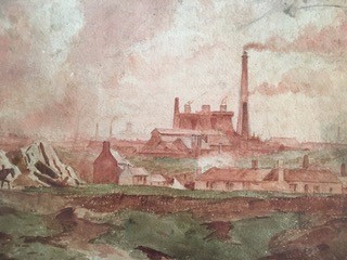
This picture appears in the book “Petit’s Tours of Old Staffordshire” and is again reproduced with permission of the Petit Society. It is believed to have been painted in 1852 or 1853 and to depict the Springvale Ironworks at Bilston to the south of Wolverhampton. It clearly shows a number of blast furnaces and other industrial buildings. In the foreground there is the depiction of a small housing settlement. The land here is greener than in the Wolverhampton painting, but still broken, looking as if it had been used for some extraction activity. The horses walking along the foreground track again give the contract between the old and the new. In the background we can see the chimneys of the Black County and perhaps, just to the left of the furnaces, a depiction of a church tower.

After some investigation, I am led to the conclusion that the painting does indeed show the Springvale works, although there is perhaps another possibility I will consider below.  In my view the painting is clearly looking east – there are too many chimneys etc in the background for a westerly view which would look out over more open country. There are two detailed maps of the area available for the relevant period – the Tithe Allocation maps of Sedgley and Bilston of 1845, and the large-scale Ordnance Survey map of 1882. Sketches prepared from both these maps are shown below. The track running north to south on the left of the sketches is the current Spring Road, and that running across the top of the sketch is the current Millfields Road. The church shown is the original Holy Trinity, not the current building. The painting shows what is referred to as the left hand “Iron Works etc” on the 1845 map and “Spring Vale Furnaces” on the 1882 map. The building in front of the furnaces is Spring Vale Iron Works on the 1845 map and Spring Vale Foundry on the 1882 maps. The maps only show the ground plan of what was in existence at the time they were produced, so the details of the furnaces and other buildings cannot be seen. Also of course all the buildings, with the exception of the furnaces, were ephemeral in nature and would be regularly modified and replaced. The canals and railways that can be seen on the maps are not visible on the painting – they would have been low lying and obscured by the topography. Most ironworks in this region were situated close to the canal which was used for both bring in raw materials and taking out finished products.

From 1845 Tithe allocation maps – blue indicates canals; brown roads or tracks
From 1882 Ordnance Survey map – blue indicates canals; brown roads or tracks

The position from which the picture is painted can be more precisely defined. A sketch from the 1845 map showing a wider area,  is shown below and indicates the likely position – at the road junction to the top left, where the name (presumably of a pub) is given as the Fighting Cocks. This is at the junction of the current Parkfield Road with the Dudley / Wolverhampton  Road. The 1845 map indicates a cluster of housing at this point. Interestingly the1882 map shows the latter road is the course of a tramway, and this might also be the case for the 1845 map, although tramways and roads are not always distinguished on these maps. If this were the case then the horses in the foregrounnd might be pulling wagons along the tramway. The ground also dips from this site towards the site of the ironworks as in the painting, although it is difficult to compare modern topography with that from the 1850s as most of the land is “made ground” of one sort or another. The painting position sits just outside John Louis Petit’s Ettingshall estate, although he did not live there, so one can conjecture that the picture was painted on a trip to the estate to conduct whatever estate business was required with his agent and tenants.

From 1882 Ordnance Survey map – blue indicates canals; brown roads or tracks; black dotted line – from painting position to furnaces

As noted above, there seems to be a church tower in the background, although this is far from clear. If this indeed is the case, then this depicts St. Bartholomew’s at Wednesbury. This church has a tower and a short spire, which was even shorter in 1853. Perhaps just a hint of this spire can be seen in the picture. The position of the church in the picture does however give confidence in the deductions of the painting position as the alignment is very much as expected given the position of painting.

As mentioned above, there is however another possibility for what the picture shows. It is possible that it depicts the Parkfield Furnaces, shown on the maps above. The reasons for thinking that this might be the case  are firstly that one might expect these furnaces to be shown on the left of the picture if the painting position is as suggested, secondly that on the 1882 map there is a long building in front of the furnaces that could be that shown on the painting, whereas no such buildings are shown the vicinity of the Spring Vale Furnaces on either map. Against this suggestion is the fact that the Parkfield Furnaces do not seem, from the maps, to have been on the same scale as those at Spring Vale. On balance my feeling remains that the picture displays the Spring Vale Furnaces.

The Ettingshall Park Estate of John Louis Petit

I have shown in an earlier post that the painter and architectural critic John Louis Petit (1802-1868) was a major landholder in the West Midlands in the nineteenth century. In this post I want to discuss in a little more detail what was perhaps the major estate that he  owned – the Ettingshall Park estate in Sedgley, to the south of Wolverhampton.

The extent of the lands owned by Petit in Ettingshall in the 1840s are shown on the map below. The estate boundaries are taken from the Tithe Allocations and are superimposed upon the 1882 Ordnance Survey map of the area. The estate was in the north of Sedgley parish, just south of the Wolverhampton boundary and the holding was 413 acres in total. It is centred on Ettingshall Park farm and lies west of another large estate – that of Ettingshall Hall. Note that part of the northern boundary is shown as a dotted line, as it is hard to locate the precise boundary on the 1882 map because of variations in the topography due to mining.

The Ettingshall Park estate. (The lands owned by John Louis Petit in the 1840s are outlined in red, and those owned by Louis Hayes Petit in green. Black triangles – collieries; red triangles – ironstone pits; green triangles – lime works; purple squares – iron works; blue circle – Sedgley Beacon

We first read of Ettingshall Park in 1581 when it was amongst the lands restored to Edward Sutton, 4th Baron Dudley, by Queen Elizabeth following the downfall of John Dudley, Earl of Northumberland who had taken over the estates through some morally dubious financial interactions with Edward’s father John Sutton, the third Baron. The fifth Baron, another Edward, sold the Estate to Charles Cornewallys of Norwich in 1597, and by 1604 it was either occupied or owned by one Thomas Marsh, styled as a gentleman. At sometime in the next century the Estate passed to the Hayes family. John Hayes appears to have been the Steward of the Dudley estate in the 1710s and 1720s and is referred to in various documents as being from Wolverhampton, and again styled as a gentleman. His son, another John, was in 1733 at the Junior Temple in London. John Hayes the elder died in 1736, and left Ettingshall to John the younger. This John himself died in 1745 and the estate went to his sisters. One of these sisters, Sarah was by then married to John Peter Petit, the second English generation of the Petits, and living at Little Aston.   It then passed down the Petit family, as is described elsewhere. The Petits did not occupy it however, and it was leased to others – in the early years of the nineteenth century to Dudley Bagley, from 1808 around 1820 to Samuel Fereday, Ironmaster, and then to his son Dudley Fereday up to the late 1850s.

From at least the end of the seventeenth century, Ettinghsall Hall was occupied by the Homers, who exploited the estate for its coal reserves. By 1780, the mining works had encroached up the estate to such an extent that it was no longer fit to be a gentleman’s residence, so Richard Homer sold it and moved to Bromley House in Kingswinford, which they also exploited and eventually reduced to colliery waste. The Gibbons family of iron and coal masters were also near neighbours in the eighteenth century.

But now let us return to the map of the estate shown above. In the 1840s it formed a coherent block of land surrounding Ettingshall Park that was owned by John Louis Petit. A small block at the south of the estate was owned by his uncle and former MP, Louis Hayes Petit. Most of the land, even at that stage was arable or pasture. There were a small number of collieries to the north west, and two lime workings at Round Hill and Beacon Hill. However just beyond the estate heavy industry was beginning to encroach, with the Spring Vale Ironworks to the north east and the Parkfields iron works to the north. The former was served by basins from the Birmingham Canal (as indeed were most ironworks in the area). The underlying 1882 Ordnance Survey map shows a similar situation in the south of the estates, with most of the field boundaries being identical to those on the tithe map, but in the north mining activities have completely eliminated the fields (and indeed makes the estate boundary difficult to determine) and indeed many of the roads shown on the tithe map. In effect the area of mining in the 1880s came right to the edge of the South Staffordshire Coal Field.

Although John Louis owned the land, he leased it to others. The central area around Ettinghsall Park Farm was leased to Dudley Fereday as noted above, with smaller agricultural plots leased to Edwin Dixon, William Fletcher and Edward Jay. The mines and pits were operated by George Jones, John Neve and Coo, or the Parkfields Company who operated the nearby ironworks. Essentially we see here, as in so many places in the western Black Country at this time, the transition from a farming to an industrialised way of life.

As noted above Louis Hayes Petit owned some land to the south of the Ettingshall estate. This encompassed the highest point in the locality at Beacon Hill. It was on this hill in 1846 that the Beacon Tower was erected, which still stands if in a somewhat dilapidated state. The Sedgley Local History society attributes the building of this tower to “a local landowner, Mt Petit”, although it might have been used for astronomical observations by Lord Wrottesley a well-known Staffordshire amateur astronomer. Whether this was John Louis or Louis Hayes is not clear, but perhaps we have here the architectural critic dabbling in architecture himself, if only in the construction of what can probably fairly be described as a folly.

Sedgley Beacon

John Louis Petit – painter and landholder

Preamble

John Louis Petit was a noted landscape painter and critic of ecclesiastical architectural practice in the 19th century. After his death, his work languished in obscurity for many years, but has recently been brought to public attention by the J L Petit Society and is well described on the website of that organisation and elsewhere. He and his sisters painted several hundred pictures of landscapes and churches across England, Europe and beyond. He was able to do so because he was from a wealthy family, descended from Huguenot immigrants to England in 1685. Concerning that wealth the Petit society web site simply says “Petit’s family were moderately wealthy landowners, active in professions, from Staffordshire“. The question then arises as to where the wealth came from that enabled him to pursue his interests through extensive and no doubt expensive, travel, This post unpacks the source and extent of his wealth in a little more depth and leads me to the conclusion that the Petit family were much more than simply “moderately wealthy”. It will be seen that the main source of this wealth seems to have been an estate in the Sedgley / Wolverhampton area, and I will investigate this estate further in a future post.

To help the reader in navigating the travels of the Petit family around the Midlands, the map below shows the places mentioned in this post that are in the vicinity of Wolverhampton.

Places named in the text in the vicinity of Wolverhampton

The Petits in England

We begin by considering the first of the Petit family to arrive in England. Lewis Petit (1665-1720), a member of the ancient Norman family of Petit des Etans, fled to England from Caen on the revocation of the Edict of Nantes in 1685, along with many thousands of others. The revocation of this edict led to severe persecution of the protestant Huguenots by Catholics, and many fled the country at that time. He served in the British army as an engineer, rose to the rank of brigadier-general and was appointed lieutenant-governor of Minorca from 1708 to 1713. He was later involved in the suppression of a revolt by Highland clans. More detail can be found in his Wikipedia entry. No doubt he was well rewarded for his services. He had two sons, John Peter Petit and Captain Peter Petit. The former married Sarah, daughter of John Hayes of Wolverhampton, the owner of the Ettingshall Estate near Sedgley, and they occupied the manor of Little Aston from 1743 to the early 1760s. John Hayes died in 1736, and left Ettingshall to his son, another John. This John himself died in 1745 and the estate went to Sarah and her sister, and thus ultimately to John Peter Petit. Ettingshall was a large, originally arable estate, that even at that stage was beginning to be exploited for its coal and ironstone reserves. John Peter also appears to have owned Saredon Hall farm in the village of Shareshill.

John Peter and Sarah’s only son, John Lewis Petit (1736-1780) was educated at Queens College, Cambridge, qualified as a doctor in 1767 and was physician to St. George’s Hospital from 1770 to 1774, and to St. Bartholomew’s from 1774 until his death. He was a Fellow of the Royal Society from 1759 and was clearly regarded as a leader in his profession. He married Katherine Laetitia Serces, the daughter of Rev. James Serces, pastor of the French Church in London. They had three sons John Hayes Petit (1771-1822), Peter Hayes Petit (1773-1809) and Louis Hayes Petit (1774-1849), but clearly lacked imagination in the giving of names. The Ettingshall Estate was inherited in its entirety by John Hayes, with financial provision being made for the other sons. In John Lewis’ will there is the following rather interesting provision.

I desire my body may be opened [for medical science] if the distemper of which I may die shall not have rendered it so loathsome as to endanger the operator and that the sum of ten guineas shall be given to the person who shall perform the operation.

Of the two younger brothers, Peter Hayes was a lieutenant-colonel of the 35th Foot and died at Deal of a wound received at Flushing in Holland during the Napoleonic war. Louis Hayes became a barrister and, from 1827 to 1832, was MP for Ripon. He bought property at Yeading, Middlesex, and a house in Tamworth Street, Lichfield. He also acquired an estate at Merridale in Wolverhampton, not far from Ettingshall, which the sources suggest provided him with income from mineral rights. This cannot however be wholly true as Merridale is to the west of Wolverhampton, and is not in fact on the coal field. It will be seen below that he also possessed land to the east of the town at Bilston, on which there were indeed coal mines, and this was probably the source oft he confusion. After ceasing to be an MP, his remaining years were largely devoted to literary and philanthropic pursuits There is a monument to him at the east end of the north aisle of St Michael’s church in Lichfield.

The Ecclesiastical Petits – John Louis and his father

The eldest of the three brothers, John Hayes Petit (1771-1822) inherited the Ettingshall estate, but also seems to have followed an ecclesiastical career. He was born in Bloomsbury and graduated from Queens College Cambridge with a BA in 1793 and an MA in 1796. He was ordained priest in Chester in 1798 and served a curacy at Ashton under Lyme near Stalybridge in Cheshire.  During his time there he married Harriet Astley of the nearby town of Dukinfield. Harriet was born in 1779 to the painter John Astley (1724-1787) and his third wife Mary Wagstaffe (1760-1832). John Astley had a colourful life, painting portraits of many 18th century notables, arousing strong passions of admiration (mainly in women) or distaste (mainly in men). His first wife was an unknown Irish lady who died in 1749. The second was Penelope Dukinfield Daniel (1722–1762) widow of Sir William Dukinfield Daniel, 3rd baronet, and a daughter of Henry Vernon, former High Sheriff of Staffordshire. John and Penelope were married with some rapidity after she intimated that the original of the portrait he was painting of her would be available if he wished. On Penelope’s death, and the death of his stepdaughter, Astley inherited the substantial Dukinfield and Daniel estates in Cheshire and was able to lead a life of some luxury and idleness thereafter.  Harriett was one of three sisters, known as the Manchester beauties, and her marriage to John Hayes would have brought him both a beautiful wife and a substantial supplement to his already considerable income. 

John Louis Petit, the artist, was John Hayes and Harriet’s eldest son and was born in 1802. For the next few years the family lived a somewhat peripatetic existence. The oldest sister, Harriet Letticia Petit (later Salt) was baptised in Stretton on Dunmore in Warwickshire in 1803. The next two children Mary Ann Petit (1805-) and Peter John Petit (1806-1852), later a Lieutenant Colonel in the 50th Regiment, were baptised at Darfield in Yorkshire. No reason for the Petit family’s presence in these places can be traced. The next two children, Emma Gentile Petit (1808-1893) and Elizabeth Petit (later Haig) (1810-1895) were baptised at Donnington in Shropshire to the north west of Wolverhampton. In January 1811 John Hayes was appointed Stipendary Curate of that parish, and then in February of that year he was appointed as a Perpetual Curate at Shareshill, to the north east of Wolverhampton where he already owned land.  How these posts interacted with each other is not clear. The Vernon family, from whom Harriet was descended, owned Hilton Hall, which was close to Shareshill, and may have been influential in John Hayes obtaining the post.  He held the Perpetual Curacy at Shareshill till his death in 1822. Their next three children were all baptised in Shareshill – Louisa Petit (1813-1842), who died after a “life of uninterrupted suffering, which she bore with a true Christian patience and cheerfulness”; Susannah Petit (1813-1897); and Louis Peter Petit (1816-1838) a barrister at Lincoln’s Inn. Around 1817 John Hayes leased Coton Hall at Alveley in Shropshire from Harry Lancelot Lee, and it was there that their final child, Maria Katherine (later Jelf) (1818-1904) was baptised. Coton Hall was a very substantial property that once belonged to the Lee family. In 1636, Richard Henry Lee emigrated to the US, and the family became rich through the ownership of tobacco plantations with a large slave population, and from whom the US Confederate General Robert E Lee was descended. It would not have been a cheap place to lease. After John Hayes Petit’s death in 1822, Coton Hall was bought by James Foster (1786 -1853), the very successful and wealthy ironmaster and coalmaster of Stourbridge.  John Hayes’ wife Harriet and her unmarried daughters moved to the house in the house in Tamworth St, Lichfield that was owned by her brother-in-law Louis Hayes Petit.

John Louis Petit inherited the Ettingshall estate on the death of his father in 1822, and also inherited the bulk of the estate of his uncle Louis Hayes Petit when the latter died in 1849. In total they formed a very substantial estate in the Wolverhampton area, that was being heavily exploited for coal, iron ore and limestone. He and his sisters also had a less tangible inheritance from his mother and his grandfather – the passion and the ability for painting and sketching. After he graduated from Trinity College in Cambridge in 1825, John firstly pursued an ecclesiastical career being curate at St Michael’s in Lichfield from 1825 to 1828, under the Perpetual Curate Edward Remington, and then curate at Bradfield and Mistley in Essex from 1828 to 1834. During his time at St. Michael’s, the registers tell us he carried out 61 baptisms, 35 weddings and 163 funerals, as well as presumably leading the Sunday worship – a not inconsiderable load. He married Louisa Reid, the daughter of George Reid of Trelawny in Jamaica in 1828. The Reid family derived much of their wealth from slave plantations in Jamaica and the family received considerable compensation for their lost income when slavery was abolished in the 1830s.

The Petit estates in the 1840s

But that is not the end of the matter. Details of the holdings of John Louis and Louis Hayes at the time of the tithe apportionments in the 1840s can be obtained from the tithe maps for Staffordshire. These are shown in the table below. It can be seen that the estates around Ettingshall and Wolverhampton were far from all their holdings. John Louis also held land in Wolverhampton itself, and in Hilton and Featherstone in the north of the town, and in Shareshill, Hatherton and Acton Trussell further to the north. At the time he lived in a house at Shifnal in Shropshire. Louis Hayes, as well as the land in Wolverhanpton also had holdings in the vicinity of the town at Sedgley and Bilston, as well as at Bushbury and Hatherton to the north. He also held the property in Lichfield where Harriet and her daughters lived. A photograph of this rather imposing property, Redcourt House, is shown below. It was situated on Tamworth Street downhill from the junction with George Lane, and its grounds extended a considerable distance behind it between what was then Back Lane and Frog Lane. In total John Louis held nearly 1100 acres and Louis Hayes nearly 450. This would have put them amongst the major landowners in the Midlands. Whilst the lands around Wolverhampton and Sedgley can be explained as an expansion of the Ettingshall and Merridale estates and the family had held land in Shareshill for several generations, there is no obvious reason why the lands at Bushbury, Hatherton and Acton Trussell came into their possession. One possible reason might be that these were holdings of Penelope Dukinfield Daniel through her descent from the Vernon family who held land in that part of Staffordshire. This might explain why John Hayes and Harriet made their home at Shareshill and the former became the Perpetual Curate in the parish.

Petit land holdings in Staffordshire in the 1840s. Numbers indicate the area in acres
Redcourt House

But there is yet more. In Staffordshire Archives, there is an index record that states ” Abstract of title of late John Louis Petit in Staffordshire and Hereford, Radnor and Brecknock “. It would appear that the property in Hereford was the estate of Bollitree Castle, a large house with mock fortifications, with Louis Hayes owned at the time of his death. I have not been able to identify any properties in Radnor and Brecknock.

Epilogue

So to return to my original query, it would seem that the Petit wealth derived in the main from a series of very advantageous marriages – and in particular those between John Peter Petit and Sarah Hayes, which brought the Ettingshall estate into their positions. This estate will be the subject of a further blog post. In addition the family were clearly successful in the professions in which they worked as a result of their very considerable talents. One point that I still find difficult to understand is why John Hayes and John Louis pursued ecclesiastical careers – the clergy stipends were almost certainly of little significance in terms of their overall wealth. Perhaps the holding of a clergy post gave a degree of respectability to a life of leisure. At any rate, John Louis gave up his post in Essex in 1834 and from the mid-1830s onwards he devoted his time to his painting and architectural criticism, and his story is told elsewhere.