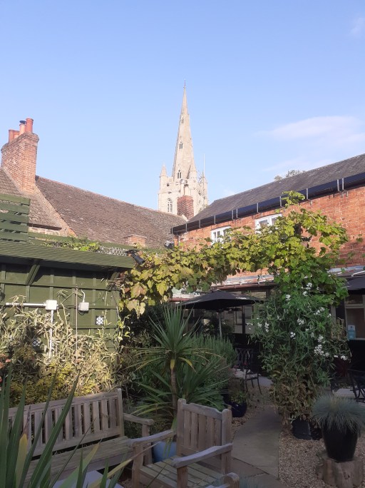
This is a picture blog, that simply gives pictures of a walk around Oakham. This is not a walk that takes in the traditional historical highlights, although some of those are included, but is rather one in which I show the things that have caught my eye, mainly on my wonderings about the town with the dog. So it is a little idiosyncratic, but I hope will be of interest to some. Except where otherwise indicated, the pictures were all taken by me, and I am happy for them to be used by others, properly credited of course.
The map
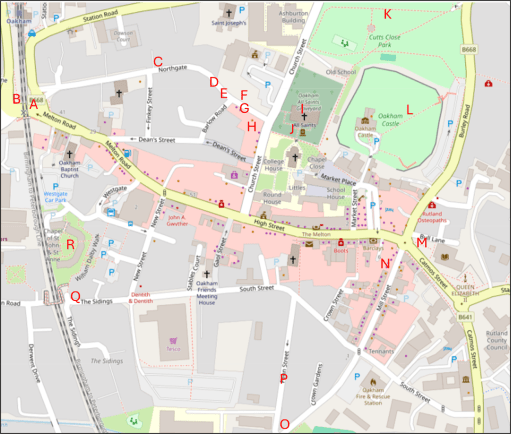
The map below shows the approximate locations from which the photographs (A to R) were taken, superimposed on an up to date map from Open Street Map.
The pictures
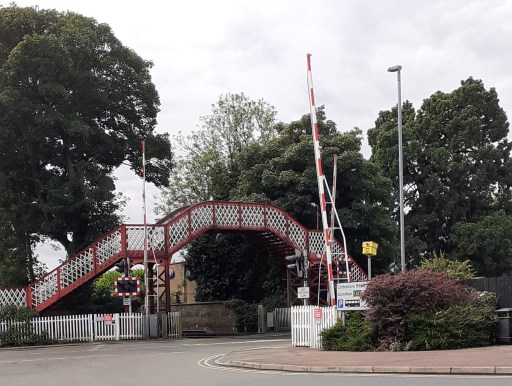
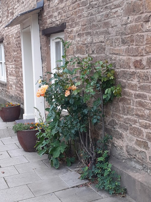
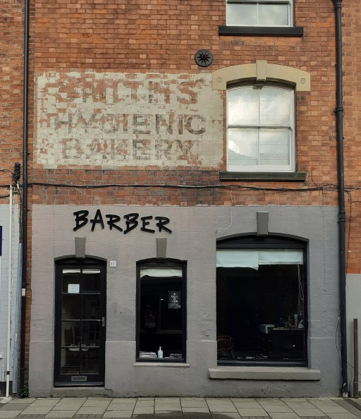
A. The railway crossingB. The signal boxC. Roses on NorthgateD. Roses on NorthgateE. Roses on NorthgateF. House on Northgate
The first picture is of the listed Midland Railway bridge and level crossing (Picture A) a source of endless frustration to drivers, and, as the location of the meeting of five roads, a horribly hazardous place for pedestrians. There must be a better way of doing traffic management here. Picture B is the Midland Railway Signal Box, which was the inspiration for the Hornby Railway model. Turning along Northgate, there are three pictures of rose bushes (Pictures C to E), some cultivated, some not. but in early summer their cumulative effect is striking. Picture F is of a house a little further along Northgate, with a wonderful display of creepers and climbing foliage.
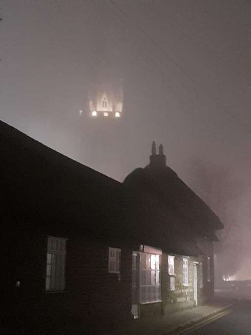
G. All Saints Church through the mistH. All Saints Church from the Wheatsheaf gardenI. Green Man carving in All Saints ChurchJ. Possible Anglo-Saxon cross at All Saints ChurchK. Castle Great Hall, Old School and Church from Cutts CloseL. Castle Great Hall, Church and Old School from Castle grounds
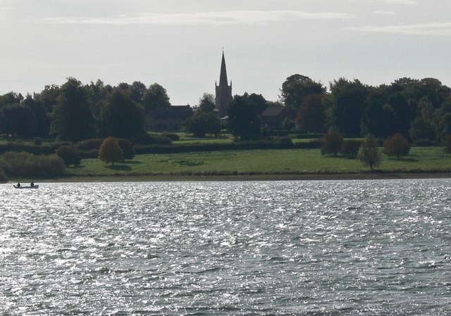
The next six photos all figure All Saints Church in one way or another. Picture G is a photo taken from Northgate on a misty evening where all that can be seen of the tower is a small floodlight area. The thatched cottages on Northgate can be seen in the foreground. Picture H shows the spire of the church from the garden of the Wheatsheaf pub opposite on a pleasant summer afternoon. Picture I (from here) shows the Green Man stone capital within the church – one of a series of wonderful capital carvings I have blogged about elsewhere. Picture J shows a possible Anglo-Saxon Saxon cross built into the south porch of the church. The identification is very speculative, but the cross is very similar to other, demonstratively, Anglo-Saxon examples. Pictures K and L shows t wo views of the Castle Great Hall, Old School and Church, from Cutts Close and the Castle grounds. I have argued elsewhere that these might be an indication of an early church group in the area. Click on the pictures to see the full extent of the photographs.
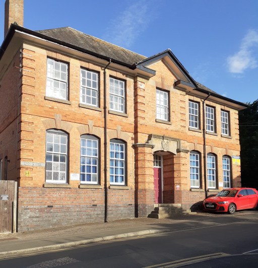
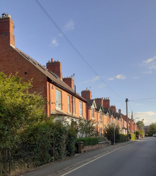
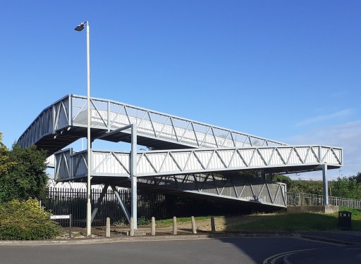
M. Ghost sign on Catmose St.N. Ghost sigh on Mill St. O. The Old Drill Hall on Penn St. P. Houses on Penn St. Q. Pedestrian bridge over the railway at the end of South St. R. The chapel of St. John and St. Anne
Pictures M and N show two nice examples of ghost signs from Catmose Street and Mill Street – faded, painted signs indicating a former usages. Picture O shows the Old Drill Hall on Penn Street which is impressive despite looking as if it could do with a bit of TLC. Picture P, also on Penn Street shows row of houses with a pleasing skyline. South Street Railway Bridge (Picture Q) is hardly beautiful, but very functional ,offering a way over the railway for pedestrians old and young, cyclists, mobility scooters, prams, shopping trolleys etc. For obvious reasons it is know in my household as the “slow bridge”. Finally Picture R (from here) shows the chapel of St John and St Anne – a medieval foundation serving the sheltered housing around it. It is the only place I know where the minister presiding at communion can watch, through the west window, the tops of passenger and freight trains passing within a few yards of the outer wall.#
Further posts on aspects of Oakham can be found using the button below.
Amended on 8th May 2024 to include further details of Our Lady’s Well.
In her book describing the architecture and liturgy of the Anglo-Saxon church in England (1), Gittos describes, in some detail, the existence of what she calls “church groups”. By this she means the practice of constructing a number of churches close to each other in some sort of relationship, which can be demonstrated archaeologically at a number of sites around England, primarily from the early Anglo-Saxon period. These usually take the form of two or more churches aligned on one axis (usually approximately east / west), sometimes with other churches on a parallel axis a few hundred metres away. The alignments can also include crosses or other monuments. Typical examples can be found at St. Augustine’s Abbey in Canterbury, with the linear group of St Peter and St Paul, St Mary and St Pancras and the non-linear groups at Hexham and Ripon. These are of course from a monastic context. Gittos hypothesizes that these churches were used for different aspects of the liturgy, with processions between them. A similar linear arrangement can be shown to have existed at the secular Yeavering site.
Figure 1. All Saints Oakham (from the south)
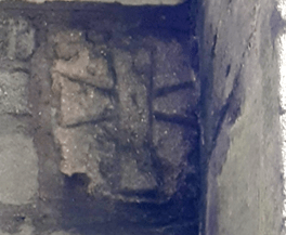
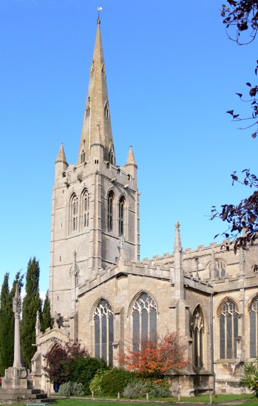
Readers of my blogs will know that I recently moved to Oakham in Rutland and have become a member of the parish church of All Saints (Figure 1). In looking at the layout of the church and its environs, it seems to me that there are some topographical hints (and I would put it no stronger than that), that this was the site of an Anglo-Saxon church group. The oldest part of the current church, the south porch, visible at the left of the photograph of figure 1, dates from around 1190, but the church almost certainly stands on the site of an Anglo-Saxon predecessor (2). In the wall of the south porch, there is what was thought to be a consecration cross, but it is visually very similar to the one shown in Gittos (p 239) from Earls Barton in Northamptonshire, that is demonstrably Anglo-Saxon (Figure 2). If the Oakham cross is Anglo-Saxon, it was presumably taken from the Anglo-Saxon church in the rebuilding of the late 12th century.
Figure 2. The crosses at Earls Barton (left) and All Saints Oakham (right)
All Saints now consists of a nave, transepts and chancel, with side chapels to either side of the chancel – dedicated to the Holy Trinity to the north, and to the Virgin Mary to the south. The original Norman church just consisted of the nave with the current transepts, the latter acting as side chapels (the communion niches, which would have been next to the altars, can still be seen). The earlier Anglo-Saxon church was probably of similar shape and dimensions.
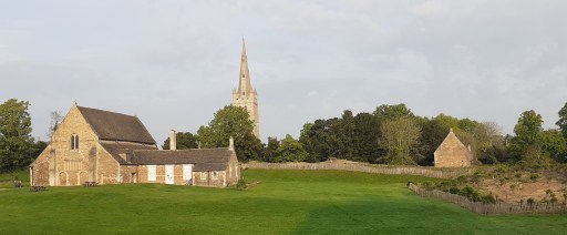
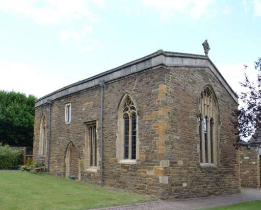
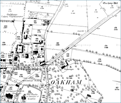
The first hint that the church might once have been part of a group arises from the fact that it lies within a substantial enclosure that now contains the Hall, inner bailey and outer bailey of Oakham Castle, as well as the church and church yard. This can be seen in Figure 3. The interesting fact is that the Great Hall of the Castle, regarded as possibly the best surviving example of Norman Domestic Architecture (Figure 4) lies fairly precisely on the same axis as the church, and eighteenth century maps show a postern gate in the wall on the alignment, offering access between the Great Hall and the church.. There seems to be no reason for these features, other than whatever was on the site before the hall was built was in some way associated with the church. Interestingly, early sources indicate that there was a chapel within the Great Hall (3) to which specific individuals held right of appointment, which suggests that it was more than simply a domestic chapel. One can thus conjecture that there was a church / chapel on this site before the castle was built in 1190.
Figure 3. The church and castle enclosure (from 1900 Ordnance Survey Map)
Figure 4. The Great Hall of the Castlefrom the south
The second indication that there was a church group comes from extending this alignment to the west. This takes it through the medieval site of Northgate, shown in Speed (4) as a large open area with a small drawing of a cross on a plinth (Figure 6). Whilst the cross is somewhat south of the strict alignment (although due west of All Saints), its presence is again suggestive. Note that alignment of the church and the castle shown on the map is not accurate and does not represent the situation on the ground. The area around Northgate was bisected by the building of the Midland Railway in the 1840s and, if the Speed map is accurate, the location of the cross was at the position of the current signal box. This is itself a grade II listed building and the prototype for model railway signal box construction kits (Figure 6). Whether or not this is enough to make up for the loss of the cross must be left for the reader to decide.
Figure 5. The Speed map of Oakham (the cross can be see on the left of the picture)
Figure 6. Oakham signal box at the site of the Northgate Cross
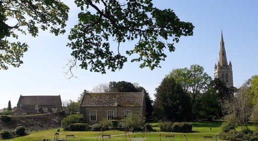
The third hint is the building to the north of the church, but on a roughly parallel axis that can also be seen in Figure 3. This is the original Oakham Grammar School, dating from just after the Reformation. It is built on the site of two former Guild chapels – one dedicated to St Mary, and one to St Michael the Archangel (3). The former included a toft, possibly the Guild Hall, and the latter at least was quite substantial, having dimensions of 60 feet by 30 feet. (3). Their topographical relationship to All Saints echoes that at Hexham and Ripon, referred to above. Perhaps here we have survivors of other ancient chapels that were part of the overall church group. Figure 7 shows a modern (i.e. May 2024) photograph of the castle (on the left), the old school (in the centre) and the church of All Saints (on the right) from the north side of Cutts Close Park (once the outer bailey of the castle). Visually they form quite a striking arrangement.
It also seems that there were another two pre-Reformation guilds at All Saints – one dedicated to All Saints itself, and presumably centred on the high altar, and one to the Holy Trinity, presumably centred on the chapel of that name within the church itself. How the Guild chapel of St Mary relates to the chapel with the same dedication in the church itself is not clear.
Figure 7. The castle, old school and church
Reference (3) also indicates that there were pre-Reformation processions to a well dedicated to St Mary a “quarter of a mile to the north of the church”, and to an image of St. Michael, possibly within the chapel of that name – another of the characteristics of church groups identified by Gittos. The well still exists. It is shown on the 1880 and subsequent Ordnance Survey maps as “Our Lady’s Well”, actually almost half a mile north east of the church (Figure 8) with a straight path across Cutts Close and the Burley Road forming a direct and prominent link between the church and the well. It is not currently accessible being in an overgrown area managed for wildlife. Our Lady’s Well and All Saints church are on quite an accurate midwinter sunset / midsummer sunrise alignment. Whether or not this was intentional I will leave for others to judge. If it was then it suggests some sort of ritual activity at the site that predates the Anglo-Saxon era.
Figure 8. Our Lady’s Well and All Saints Church (from an 1880s OS map – the church is in the bottom left and the well in the top right).
At this point it is also worth noting that there is another surviving chapel in Oakham – that of the medieval Alms Houses of St. John and St Anne. This is however, not on the same alignment as the cross, church and castle and is some distance to the south west, and not likely to be part of any group. Neither is it in any sort of solar alignment with All Saints, being too far north to lie on the All Saints / Lady Well alignment. But the dedication is rather odd and perhaps hints at an earlier history.
So we can conjecture that we have here the surviving topography of a church group, with one church on the site of the current church in a linear alignment with one on the site of the Castle Great Hall and a cross at Northgate, and two on the Old School site where the guild chapels once stood. A church or chapel on the site of the current chancel of the church of All Saints is also a possibility. In making this suggestion we are of course making major assumptions that all the current buildings stand on the site of Anglo-Saxon originals, for which the evidence, such as it is, is very weak. There is also no evidence that there was ever monastic activity at Oakham, which seems to have been the context of many early church groups. So the suggestion that we have here the remains of a church group, attractive as it is, must only be regarded as very speculative.
References
Gittos H (2015) Liturgy, Architecture, and Sacred Places in Anglo-Saxon England, Oxford University Press, 978-0198737056
Aston N (2003) All Saints’ Oakham. A guide and history. Friends of All Saints, Multum in Parvo Press.
Speed J (1611) Theatre of the Empire of Great Britaine. Modern version by Nigel Nicolson (1998) The counties of Medieval Britain. A Tudor atlas by John Speed. Pavilion Books Ltd.
By way of introduction, you will see that in Worship for the Week I am referred to as a professor, which seems to give this address some level of academic respectability. And while that appellation is true enough, my actual title is Professor of Environmental Fluid Mechanics, and I have spent my career teaching civil engineering students. In terms of expertise on Queen Edith, I fear, ladies and gentlemen, you have an imposter in your midst. But let’s see where we get to.
Edith of Wessex was born sometime around 1024 or 1025, so saying we are celebrating the 1000th anniversary of her birth is a bit of a guess, but not a bad one. Her father was one of the most powerful men in the country at that time – the Saxon Earl Godwin. Her mother was Danish, Gytha, a relative of Cnut, the then king of England, Norway and Denmark. England was that time was an ethnically and linguistically very diverse society with the undoubted tensions that resulted. Edith’s brothers and sisters mostly had Danish names, and she too most probably was given a Danish name that was to be changed when she married. I think it likely her mother tongue was Danish. She was brought up and educated at Wilton Abbey near Salisbury, and came to speak Danish, English, Latin and Irish fluently. She also was very capable in weaving and embroidery and, we are told, in a work she commissioned, accomplished in grammar, rhetoric, arithmetic and astronomy.
After the death of Canute and his son Harthacnut, the Anglo-Saxon dynasty that their ancestors had forced into exile was re-established in 1043 with Edward, ultimately to be known as Edward the Confessor, taking the throne. Edith was married to Edward in 1045 and, unusually for the time consecrated as well crowned as queen. For the first few years of her marriage, she would have lived in the shadow of Edward’s mother, the dowager queen, Emma of Normandy, the wife of Edward’s father Aethelred, and then the wife of Canute, a redoubtable and quite ruthless lady. I would imagine there were mother-in-law issues. The marriage was childless, which no doubt caused both personal and political tensions. In 1051, Godwin came close to armed rebellion, and he and his family were forced into exile, with the loss of his titles and his lands. Edith also fell out of favour and was consigned to a nunnery, perhaps as a prelude to a planned divorce because of her childlessness. Just over a year later, the situation was reversed, and Edward, faced with the threat of an armed conflict that he could not win, was obliged to reinstate Godwin to his former titles and lordships, and over the next 13 years, the Godwins became very powerful, holding most of the large earldoms in England. Edith too was released from the convent and reinstated as Queen. She was to become a close confidante and advisor to her husband, a de facto if not de jure member of the Witan, his body of counselors. We are told she took care to ensure that his royal dignity was appropriately displayed in his dress and his presentation. She acquired large estates and became a very wealthy woman – including most of Rutland, which were the dower lands of the later Mercian and Anglo-Saxon queens. That wealth was also used in generous benefactions to the church, particularly in Winchester and Abingdon.
The question of succession was ever apparent. Edward brought back to his court other members of the Anglo-Saxon dynasty who had been in exile following the Danish takeover, and Edith took on parental responsibilities for the young boy Edgar, named the Aetheling as being eligible for the throne, and his sister Margaret, who Edith arranged to be educated at Wilton. The latter was to marry Malcolm Canmore, King of Scotland in around 1070, for whom, allegedly, Birnam Wood to Dunsinane didst come, and it was through their descendant’s marriage into the Norman royal line that the ruling family of England again came to be connected to Cerdic, the sixth century founder of the Wessex dynasty. In retrospect, Edith’s care for the child Margaret was thus to be of major long-term significance.
Over the latter part of his reign, Edward became increasingly occupied by the building of the Abbey Church at Westminster, which was consecrated in December 1065, just before his death and burial there in January 1066. The succession question then became critical. The claims of Edgar the Aetheling were swept aside, and the throne was taken by Harold Godwinson, Edith’s elder brother. This was disputed by both the King of Norway and, of course William of Normandy. By October that year, Edith had lost not just a husband, but her brother Tostig at the battle of Stamford Bridge, where he fought against Harold on the side of the Norwegian king, and three other brothers at the battle of Hastings. Edith submitted to William at Winchester and was allowed to keep her estates, the only surviving member of the Anglo-Saxon royal family to remain in England. In the years before her death in 1075, she continued to be a benefactor of various churches, and if some historians are correct, was instrumental in the design and production of the Bayeux Tapestry, or more properly the Bayeux embroidery. She also commissioned a book on the life of her husband and continued to manage his reputation after his death – and her actions were in large part responsible for his cannonisation several hundred years later. In the Anglo-Saxon Chronicle of 1075, we read
Edith the Lady died seven nights before Christmas in Winchester, she was King Edward’s wife and King William had her brought to Westminster with great honour and laid her near King Edward, her lord.
But what can we say about Edith as a person? Well, it depends upon what you read – the sources that we have can best be described as propaganda for various parties. They were either produced under the direction of Edith herself, or by those who saw her as a traitor. They describe her variously as moderate and wise, or hard and interfering. She is also alleged to have been involved in a number of church and court intrigues and was accused of rapaciously appropriating religious relics from churches around the kingdom and giving them to those she favoured. and of facilitating the murder of a Northumbrian noble, on behalf of her brother Tostig, the then Earl of Northumbria. It is simply not possible to say whether these descriptions or the allegations were true, and most probably have the same level of historical reliability as the Marriott Edgar poem that sees, at the conclusion of the Battle of Hastings
King Harold so stately and grand, Sitting there with an eyeful of arrow, On his horse, with his hawk in his hand.
But, with regards to Edith, taking all things together, it is probably fair to say that she was no saint. The words of Dylan Thomas through the Rev Eli Jenkins of Llareggub seem applicable.
We are not wholly bad, or good, who live our lives under Milk Wood.
In our consideration of the life and times of Queen Edith, we see the emergence of much that contributes to our modern world, and many historical parallels and continuities. Our language is a direct descendent of the one of those that Edith spoke; our constitutional monarch is still a descendent of Cerdic; in the gathering of counsellors around the king on the Witan, we see a foreshadowing of our system of government; and the system of shire, shire reeves and shire courts that underpinned late Anglo-Saxon England, we see the foundations of our local government and legal systems. Indeed, the very existence of Rutland is due to it being Edith’s dower lands, and she has left her name in one of its villages. And shire reeves are of course still around. Despite these solid foundations, English society in Edith’s time was in a state of turbulence – divided by ethnicity, politics and language; threatened by external powers; at the mercy of the ambitions of powerful men, again foreshadowing something of current tensions in our own society and around the world. The life of Edith herself also evokes many modern issues some of which have a particular resonance for Mothering Sunday – the shame of childlessness, the struggles of an arranged marriage, the pain of loss of family and friends on the one hand and devotion to husband and adopted children on the other. And above all the simple struggle for a woman to survive in a male dominated society. And this is perhaps the most significant thing about Edith – she was a survivor – a woman who tried to hold things together as family and society were falling apart; something we see in the faces of women in refugee camps and war zones around the world.
But there is I would suggest a deeper continuity between Edith’s times and ours, one that is perhaps not obvious in our secular age where religion is largely seen as a private pastime, and spiritual experiences and realities dismissed. But in Queen Edith’s time that was not the case, and the spiritual was enmeshed in everyday life to a degree we would find hard to understand. Prof Richard North of University College London writes of the perceptions of the Anglo-Saxons in the pre-conversion era, with words that are equally applicable to Edith’s time, that spiritual realities
…were varied and widespread, and to the heathen mind in the early seventh, if not our own blind folly in the twentieth century, the world was charged with their power.
It is perhaps the rhythms of our worship that are a clock through which we can come to a deeper understanding of Edith’s times – as we go from Advent to Pentecost, from Lady Day to Michaelmas, we experience the unfolding of the scriptural and seasonal narratives with which those of Edith’s day would have been familiar, rhythms that would have constrained and ordered her life. She would have experienced the daily rhythm of the nunnery – the Magnificat sung in Latin at Vespers and the Nunc Dimittis at Compline. And further, whilst there can be no certainty, it seems to me highly likely that at some stage in her 20 years of marriage, Edith would have visited her dower land in Rutland, and we can imagine her in one of her manorial churches in Ridlington, Hambleton or Oakham, and can picture her participating in the mass or Eucharist that has been regularly celebrated down the centuries in these churches, with very few breaks – perhaps only in the interdict of King John’s Day, the turmoil of the Civil War, and most recently during the Covid lockdown. They were presided over by priest’s wearing very similar vestments to those used today – indeed when it was suggested we dress up as Anglo-Saxons at yesterday’s events, I thought about simply turning up wearing the Eucharist vestments! And the liturgy that she would have taken part in there would have been very similar indeed to the Eucharistic ceremonies of today – in Latin rather than English, but nonetheless essentially the same. God is praised, his saving work for the reconciliation of all things to himself is narrated, bread is broken, and wine is shared. I would suggest that it is in our worship that we can understand the rhythms of Edith’s time, and in which we find the deepest continuities between past and present.
And the Eucharist of course points to a yet deeper continuity, a longer thread, a thousand years before Edith – to Jesus and his disciples eating the Passover meal in Jerusalem just before his death and, three days later his resurrection. And that Passover celebration itself points to an even more remote time perhaps twelve hundred years before that, in a time and culture that for us would be utterly strange, as the people of Israel fled from Egypt to worship their God Yahweh, I am what I am, in the cloud and the fire on Sinai.
As Edith, with all her flaws and ambiguities, watched the mass in her Rutland churches, as we, being all too aware of our inadequacies, similarly eat the bread and drink the wine of the Eucharist here in Oakham, as we move in the rhythm of the year towards Lady Day, Good Friday and Easter, we become part of that long thread of history that takes us back to Sinai and Jerusalem, and to the England of a 1000 years ago, in which we join with all God’s children, alive and dead, the saintly and the not so saintly, and become part of the outworking of God’s plan for the salvation of the world.
It thus seems appropriate to end with words of praise to God – the words of the earliest known English hymn – that of the Northumbrian cowherd Cadmaeon from the late 7th century.
Now we must praise – the protector of the heavenly kingdom the might of the measurer – and his mind’s purpose, the work of the glory father – as he for each of his wonders, the eternal Lord – established a beginning. He shaped first – for the sons of the earth heaven as a roof – the holy maker; then the middle-earth – mankind’s guardian, the eternal Lord – made afterwards, solid ground for men – the almighty Lord.
One of the most interesting features of the parish church of All Saints in Oakham is the set of elaborately decorated capitals at the top of the pillars supporting the arches in the nave. The subject matter includes biblical stories, images of grotesque beasts, angels, devils and a green man. This blog posts will consider these capitals in some detail, trying to understand what is represented on each one, and speculating as to whether or not there are relationships between some or all of the individual designs.
There have been a number of descriptions of the capitals in the past – the Victoria County History for Rutland (1), Pevsner’s Buildings of England (2) and Aston’s Guide and history of the Church (3). These will be referred to as VCH, Pevsner and Guide in what follows. In addition, Lionel Wall has a web page on his “Great English Churches website (4), with many photographs of the capitals. These are significantly better than the photographs I have managed to take, and he has kindly given me permission to use them in this post. Thus nearly all the photographs in what follows are from this source, although they have all been rendered in greyscale for comparative purposes. However, I will use a few of my own photographs, which will be clearly distinguished in what follows, even if only by their poor quality.
I have adopted an identification system for the Capital carvings, and this is shown in figure 1 below, the underlying plan being taken from (1). T indicates the carvings on the Tower capitals, C those on the chancel, CA those on the chancel arch and P1, P2 and P3 those on the pillars. N indicates those on the north side of the church, and S those on the south side.
Figure 1. Key to the Capitals – plan taken from (1)
On P1N, P2N, P1S, P2S and P3S the carvings encircle the capitals, whilst on P3N the carving is only on the Nave side. TN, TS, CN, CS, CAN and CAS are, due to the local geometry, carved on one side only. CAN and CAS have been partially damaged by the installation, and possibly the later removal, of the Victorian rood screen.
I will begin by looking at the Capitals in turn, and then move on to speculating as to the nature of a possible overall arrangement with links between the individual designs.
Descriptions of the Capitals
Tower North (TN)
VCH – expulsion from Eden; Pevsner – expulsion from Eden; Guide – the expulsion of Adam and Eve from Eden
Figure 2. The Tower North Capital
The three earlier descriptions are clearly correct, but more can be said. The carving on the left of figure 2 shows Adam and Eve either side of either the Tree of Life or the Tree of the Knowledge of Good and Evil – there is debate amongst scholars as to whether or not these names refer to the same tree. The serpent can be seen between them (Genesis 3.1-6). Eve’s arm is extended to Adam, perhaps offering him the apple from the tree. The figure on the right shows the pair being expelled from the garden, with the angel with flaming sword depicted blocking the way back (Genesis 3.23-24).
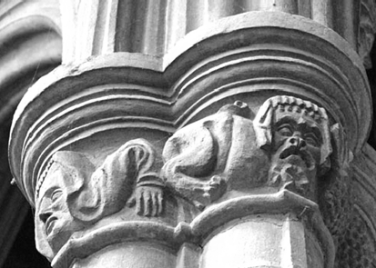
Pillar 1 North (P1N)
VCH – grotesque heads and hands; Pevsner – grotesque figures; Guide – grotesque heads and legs
Figure 3 Pillar 1 North Capital (photographs by author)
The four figures are indeed grotesque, with faces showing a range of expressions from aggression to horror. If they represent anything at all other than the stonemason’s fancy, they could represent the state of fallen humanity, or be representations of demons. This capital was very difficult to photograph because of the lighting conditions, and the pictures are not all that I would wish for.
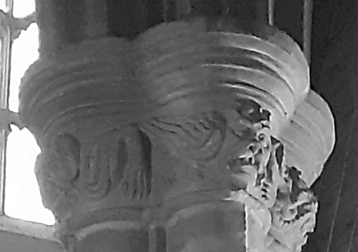
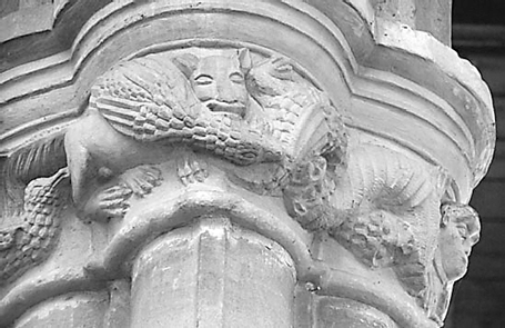
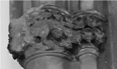
Pillar 2 North (P2N)
VCH – grotesque heads and limbs with a dragon biting itself; Pevsner – dragon; Guide – grotesque heads and a dragon.
Figure 4. Pillar 2 North Capital
There are more grotesque heads on one side of the capital, a male and a female in my view, with a coiled dragon on the other. The dragon only occurs in scripture at several places in the book of Revelation, where it is unambiguously a representation of Satan. So perhaps we have here a picture of the oppression of humanity by the devil. The two faces have animal like bodies however, so perhaps these too are meant to represent demons or evil spirits.
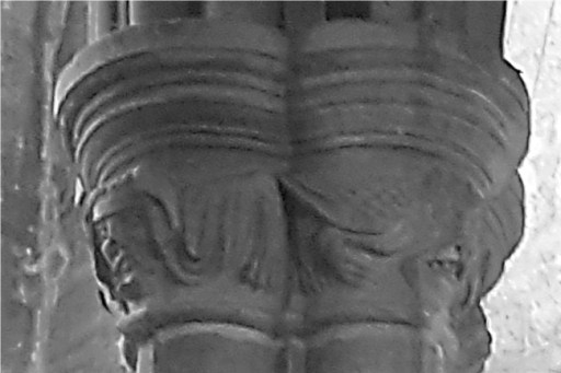
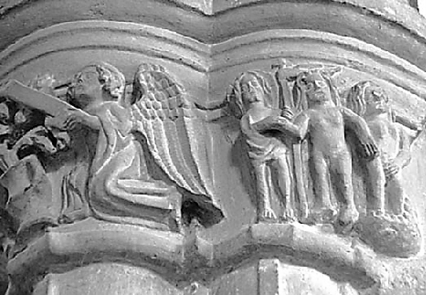
Pillar 3 North (P3N)
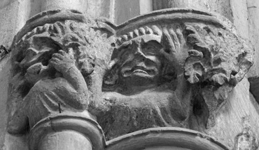
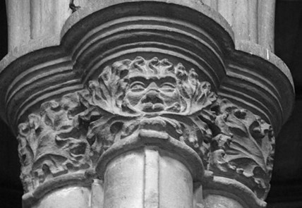
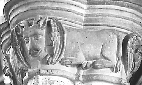
VCH – foliage; Pevsner – leaves; Guide – the Green Man.
Figure 5. Pillar 3 North Capital
Oddly both VCH and Pevsner miss the main feature of this Capital – a rather fine Green Man with foliage sprouting from its mouth. This design is on one side of the capital only. The notion that the Green Man represents a survival from pagan worship has been thoroughly debunked in recent years (5), and historians have demonstrated an origin in India that came, via the Arab world to be used with a decorative function in European churches. In terms of Christian iconography, some think that Green Men with foliage springing from their mouths, such as the one here, reflected the Golden Legend of Jacobus de Voragine, from the 13th century, which describes how Seth, the third son of Adam, planted seeds from the Tree of Life in his dead father’s mouth as he lies in his grave. The tree that grew from them became the tree of the true cross of the crucifixion. The figure could thus represent the death mask of Adam, with a foreshadowing of the cross and resurrection.
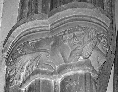
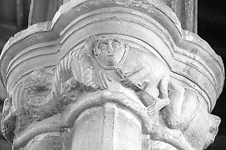
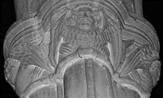
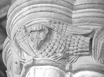
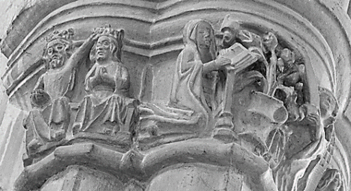
Chancel North (CN)
VCH – a beast-like figure playing upon a musical instrument, the figure ending in foliage; Pevsner – not described; Guide – a beast with a human head plays an instrument.
Figure 6. The Chancel North Capital
The decoration on the pillar next to the chancel show a winged beast with a human head playing an instrument that looks like a lyre, using a bow. The only meaning I can give to this is that it is a Siren of the legends of antiquity, that lured sailors to their death by the beauty of their song – the medieval period was much influenced by such classical legends. As such it may represent the alluring temptations of sin.
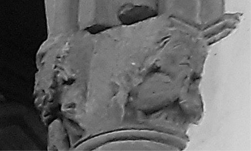
Chancel arch north (CAN)
VCH – not described; Pevsner – not described; Guide – not described.
Figure 7. The Chancel Arch North Capital (right hand photograph by author)
This carving was damaged by the installation of the Victorian rood screen, long since removed. Thank you, Gilbert Scott. The front figure shows two figures making faces, and there was presumably a third to the right. Around the back however, on the other side of the rood screen damage, there is a much more serious, although rather worn, person in prayer. What this all represents is beyond me – I am inclined to think it is simply the sense of humour of the mason.
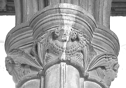
Tower South (TS)
VCH – rich foliage and a pelican in piety; Pevsner – birds; Guide – the pelican in her piety – symbol of the sacrament.
Figure 8. The Tower South Capital
The identification of the Pelican with Holy Communion is well set out in the following quote from the Catholic Education Resource Centre (6).
The symbolism of the mother pelican feeding her little baby pelicans is rooted in an ancient legend which preceded Christianity. The legend was that in time of famine, the mother pelican wounded herself, striking her breast with the beak to feed her young with her blood to prevent starvation. Another version of the legend was that the mother fed her dying young with her blood to revive them from death, but in turn lost her own life. Given this tradition, one can easily see why the early Christians adapted it to symbolize our Lord, Jesus Christ. The pelican symbolizes Jesus our Redeemer who gave His life for our redemption and the atonement He made through His passion and death. We were dead to sin and have found new life through the Blood of Christ. Moreover, Jesus continues to feed us with His body and blood in the holy Eucharist.
On the Capital we have the pelican and her chicks on a nest in a tree – perhaps again representing the Tree of Life.
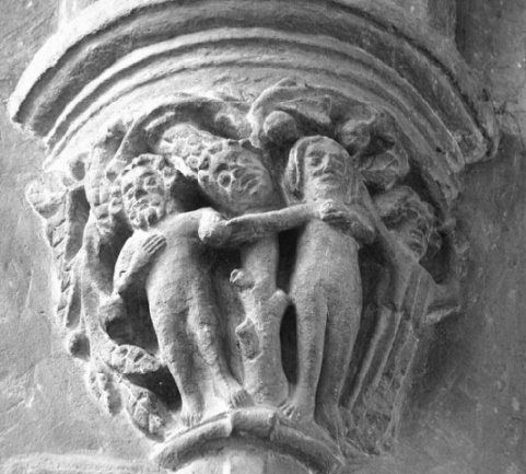
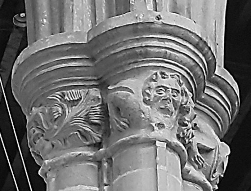
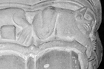
Pillar 1 South (P1S)
VCH – fox stealing goose followed by goslings and man with a besom, and on the other side an ape with his clog; Pevsner – a fox, an ape with a chain ending in a clog; Guide – the legend of Reynard the Fox.
Figure 9. Pillar 1 South Capital
This is perhaps the most complex of the carvings and certainly the most difficult to interpret. VCH and Pevsner’s descriptions are brief and partial, whilst that of the Guide makes quite a firm statement as to its content. The Guide goes on to give the following further explanation.
The carving of Reynard the Fox is similar to that at Tilton on the Hill, 8 miles west in Leicestershire. At Oakham Reynard is seen on the north side of the capital, with a goose in his jaws, followed by goslings. A man points his distaff at the fox. A fettered monkey is also depicted, and two snake-like creatures intertwine, each biting the others tail. The fox may represent the Abbot of Westminster making off with the great tithe, leaving only the small tithe for the local priest (the fettered monkey). Alternatively, it could be and illustration of Chaucer’s Nun’s Priest tale.
I find some of this very debatable indeed. Firstly, my reading of the medieval stories of Reynard the Fox suggests he is primarily a trickster, and I can find no reference to him stealing a goose. The Nuns Priest’s tale is perhaps a better fit. A summary from the Harvard Geoffery Chaucer web site (7) reads as follows.
In a chicken yard owned by a poor widow, the rooster Chaunticleer lives in royal splendor with his seven wives, of whom his favorite is the fair Pertelote. He dreams that he is attacked by a strange beast (a fox, which he does not recognize because he has never seen one). Pertelote advises he forget the dream; dreams, she says, come from indigestion. Chaunticleer insists on the power of dreams to predict the future. But he takes her advice. Later that day a fox appears and by trickery seizes Chaunticleer and carries him off, pursued by all of the old widow’s household. Chaunticleer tells the fox to taunt his pursuers; the fox opens his mouth to do so, and Chaunticleer is free to fly into a tree. Chaunticleer, the fox, and the narrator all draw morals from the adventure.
The specific moral of interest is a warning against vanity – as demonstrated by both Chaunticleer and the fox.
As the fox seems to have dropped the “goose” from his mouth, and he is pursued by seven “goslings”, this would seem to fit with at least part of the Capital depiction, although how well a stonemason might be expected to know what was essentially a courtly tale is debatable. It could however be based on a folk tale that was used by Chaucer for his composition.
But, there are other characters in the carving that certainly don’t figure in the Nuns Priest’s tale: the recumbent man holding a distaff (but why should be holding a distaff, usually the symbol of a women, is another issue); the creature with the chain around its neck which is almost certainly an ape or a monkey – the “weight” that seems to hang from it is a clog – a wooden block that was used to attach to a chain (although the animal appears unfettered); and the serpentine figure between the fox and the ape.
I presume the notion that this is representative of the disagreements between the clergy of Westminster Abbey and the local clergy has a source somewhere, but I have never come across it, and why the former should be represented by a fox and the latter by an ape / monkey is a bit of a mystery.
So what are we to make of this? Perhaps the answer lies in Christian symbolism. Foxes are occasionally mentioned in scripture, almost always negatively. Jesus refers to King Herod as “that fox” (Luke 13.32). In the Song of Solomon we read
Catch for us the foxes, the little foxes that ruin the vineyards (Song of Solomon 2.15)
Perhaps we have here the likely meaning – the fox is a symbol of and of the sins of church members that are the ruination of faith – in particular, if the Nuns Priest’s tale is referred to, the sin of vanity. In Christian iconography, monkeys or apes represent base instincts such as lust, greed and malice, particularly when unchained (8). The snakes might also be representations of the devil. So taken together we might have an allegorical representation of the sins that defile individuals and the church. But the level of speculation here is becoming excessive.
Pillar 2 South (P2S)
VCH – four angels; Pevsner – four angels; Guide – four angels facing the points of the compass.
Figure 10. Pillar 2 South Capital
The four angels are indeed facing in the four cardinal directions. They are all quite similar in form. Symbolically they may simply be an indication of the protection of God’s people, or they might refer more explicitly to the four angels of Revelation 7.1.
After this I saw four angels standing at the four corners of the earth, holding back the four winds of the earth, that no wind might blow on earth or sea or against any tree.
The winds here indicate the coming judgement of God on the world, held back until the right time by the heavenly powers.
Pillar 3 South (P3S)
VCH – symbols of the four Evangelists; Pevsner – signs of the Evangelists; Guide – the four Evangelists
Figure 11. Pillar 3 South Capital (bottom two photographs by the author)
These figures do indeed represent the four gospel writers – Saint Luke (Ox – top left picture), Saint John (Eagle – top right picture) and St Mark (Lion – bottom left picture) and Saint Matthew (Angel – bottom right picture). These in turn reflect the natures of the four living creatures of Ezekiel’s vision from the Old Testament, the seraphim bearing the throne chariot of God each with the same four faces. Ezekiel 1.10 describes them as follows.
Their faces looked like this: Each of the four had the face of a human being, and on the right side each had the face of a lion, and on the left the face of an ox; each also had the face of an eagle.
This chapter, and its associated symbolism, was very influential in early Christian and Jewish apocalyptic literature (9). These symbols then probably represent the Word of God, and the presence of God.
Chancel South (CS)
VCH – the Expulsion from Eden, the Annunciation, the Coronation of the Virgin; Pevsner – Adam and Eve, the Annunciation and the Coronation of the Virgin; Guide – Coronation of the Virgin – the Annunciation.
Figure 12. Chancel South Capital
This is perhaps the most intricately carved of all the capitals in All Saints. There are three scenes. The first shows a king crowning a queen, taken as being the Crowning of the Virgin Mary in heaven by either God the Father or her son Jesus, also crowned – a thoroughly non-biblical story. The very anthropomorphic nature of the scene suggests to me that this is based on a model of the coronation of a medieval queen. The second scene is a representation of the Annunciation – the appearance of the angel Gabriel to Mary to announce the coming birth of Christ. Between Mary and Gabriel, we can see the Lily – the symbol of Mary. Finally on the right we seem to have another Adam and Eve scene, accompanied by an angel with a scythe – perhaps representing the final harvest of souls, where the first couple are given a vision of the redemption of the world by the son of Mary.
Chancel arch south (CAS)
VCH – not described; Pevsner – not described; Guide – damaged by the Victorian rood screen
Figure 13. Chancel Arch South Capital (photograph by author)
As with the north chancel arch carving, this was damaged to install the Victorian rood screen. Its contents are not clear, but seem to be largely foliage. However it is perhaps possible that some of the foliage is actually small heads, and digits, but there is too much damage to be certain. Again, hearty thanks are due to Mr Scott for his contribution.
A bigger picture
So, having discussed all the Capital designs individually, is it possible that they fit into an overall scheme in some way? In what follows I will try to make the case that there is an overarching theme that connects all the designs, although in doing so, I am conscious I might simply be reading too much into the available evidence – and that the collection simply represents the imagination and arbitrary decisions of the masons.
Figure 14 below is an annotated version of Figure 1 that will help to understand the musings that follow with relationships between the different capitals indicated by arrows. Firstly, there are clear similarities of them between TN and CS – the story of Adam and Eve, both at the creation and at the end of time. These are on a diagonal across the church. Moving clockwise PIN and P3S are clearly similar although opposites of each other. – grotesque animals and faces in the former, with a devilish aspect, with similar, but sanctified beasts in the latter representing the evangelists. P2N and P2S are also opposites – the devil in the former and the angels in the latter. Carrying on clockwise, we come to P3N (the Green Man) and P1S (the fox and his entourage). It is hard to see much in common or in opposition here, other than their ambiguity of meaning. Perhaps in the former we see good coming from evil, whilst the latter shows that evil is always aiming for a comeback. Then we come to CN and TS – both featuring birds or winged beast – the first luring humanity to sin, and the second showing the cure for sin – the eucharist. That leaves us with the chancel arch decorations – I can see no linkage here, and, if there is an overall plan to the other carvings, I do not think these are part of it.
Figure 14. Relationships between Capitals
Overall then, these carvings seem to show a set of images in opposition to each other across the nave of the church – symbols of evil and darkness on the north and symbols of redemption and light on the south – which is quite consistent with many aspects of church and churchyard architecture.
One final puzzle however – nowhere I the carvings is there an unambiguous representation of Christ, unless that be in the scene of the Coronation of the Virgin. This seems to me odd, but perhaps the reader better versed in medieval symbolism might be able to enlighten me.
Since moving to Rutland last summer, I have come to realise that there are a number of enigmas in the early history of the county. Firstly, there is the fact that the county was the last one to be formed, and at Domesday, the northern Wapentakes of Alstoe and Martinsley were a detached part of Nottinghamshire, and the large double-hundred of Witchley in the south was part of Northamptonshire. In his consideration of this issue, Phythian-Adams (1), suggests that there was an underlying unity to the area that was to become Rutland, as it was formed from the dower lands of the late Mercian and Anglo-Saxon queens, and as it was also a Royal Forest, and that the split between Nottinghamshire and Northamptonshire occurred at some point during the period of the five Viking boroughs. This seems to have been generally accepted and seems to me quite plausible. Phythian-Adams also speculates that this area might have a longer history as a discrete unit. I have taken these thoughts a little further in a recent blog, and, noted that Rutland is essentially the upper catchment of the River Welland, whilst neighbouring South Kesteven is the catchment of the River Glen that joins the Welland east of Stamford. This of itself falls into the pattern of some early Anglo-Saxon polities in being based on river catchments, but the fact that both rivers run into the heavily managed fenland, in this case in the region of the Spalde of the Tribal Hidage (2) suggests that both Rutland and Kesteven would have required some authority, at least in terms of water management. I went further and suggested that these two polities could have been the East and West Wixna mentioned in the Tribal Hidage, as the order in which that document lists the polities in the fenland area, places them between the Gyrwe around Peterborough on the Nene and the Spalde to the north i.e. consistent with the geographical locations of Rutland and South Kesteven.
The second enigma is that within the county there are a number of place names that refer to the Anglo-Saxon tribe of the Hwicce. These have been investigated by Green (3) and include Witchley Warren, Witchley hundred, Whissendine and Witchely Leys. The Hwicce of course are known in the historical record as a West Midland polity, based around Worcestershire and Gloucestershire, so the existence of these names in Rutland is somewhat odd, and suggests that at some point in their history, at least a part of the Hwicce were resident in Rutland – probably before they became established in the Worcestershire area, so perhaps in the early sixth century. Phythian Adams (1) also points out that, on the western boundary of the county, there are a number of place names that refer to beacons, military guard posts etc., which suggest that the Rutland Hwicce had need to be wary of their neigbours to the west. I have addressed this issue in a second recent blog post, suggesting that the possible area name of East Wixna is another indication of the presence of the Hwicce, and also pointing out that in 1066 Queen Edith, the wife of Edward the Confessor, as well as holding much of Rutland in Lordship, was also the Lord of a large cluster of manors in Herefordshire, in the area usually ascribed to the Magonsaete tribe, sometimes referred to as the Western Hecani, or Hwicce. How far back these holdings go would require a detailed study, but on the face of it, it does suggest enduring links between Rutland and what was to become the main territory of the Hwicce.
There is however a third enigma – the often-observed fact that the place names within Rutland are overwhelmingly English, despite being surround by Danish areas, which suggest that although the Danes might have had political control of the area, they did not settle there. Phythian-Adams (1) speculates that this was due to an agreement in 893 between a representative of King Alfred of Wessex and the Danes of York, who seemed to be exercising political control in the area, because Rutland was the dower of the late Mercian queens – and thus of his own sister Aethelswyth, the wife of the last King of Mercia, Burged who was deposed by the Danes, and possibly his daughter Aethelflaed, the Lady of the Mercians who was married to Ealdorman Aethelred. Whist this plausible, I do not find it wholly convincing as a reason for Wessex to strike such a bargain with the Danes, presumably at some unspecified cost. In what follows I speculate on a further reason why the rules of Mercia, and later Wessex, might wish to retain Rutland as a specific English-speaking area. I will base this on the work of Green (4), who proposed a wave of migrations eastwards and northwards from Lincolnshire in the early sixth century, and of Jones (5) who mapped the place names associated with the early members of the Mercian royal house.
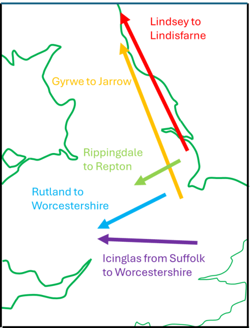
East of England migrations
Through a detailed consideration of place and tribal names Green (4), in her extensive discussion of Anglo-Saxon Lindsey, shows, conclusively to my mind, that Lindisfarne off the coast of Northumbria, was colonized by settlers from Lindsey in Lincolnshire. She puts this migration in the early part of the sixth century, on the basis that the Anglo-Saxon Chronicle shows Anglo-Saxon expansion from Lindisfarne after 550, with activity around Bamburgh and Yeavering on the mainland. Further she notes that the other main centre of Northumbrian activity was at Jarrow, the early forms of the name are Gyrwe – the same as the people from the Tribal Hidage in the region of Peterborough. Thirdly she notes that Rippingale in Lindsay is cognate with the name Hrepingas, the tribe in the area around the Mercian ecclesiastical centre of Repton. She then further refers to the point that has been made above, that there are many place names in Rutland that relate to the Hwicce. All these relationships and possible migrations are shown on Figure 1. Taken together they show a considerable Anglo-Saxon expansion from the Lincolnshire / Fenland / Ruland area. It seems to me likely that these all occurred in the first part of the sixth century, on the basis of the formation of Northumbria, and that by a century later, Mercia and the kingdom of the Hwicce were well established. This timing suggests that this movement of peoples was associated with the climate catastrophes of the 530s (possibly due to a major volcanic explosion) and the spread of the Justinian plague across Europe in the 540s (6).
Figure 1. 6th Century Anglo-Saxon migrations from the East Midlands (after Green (4))
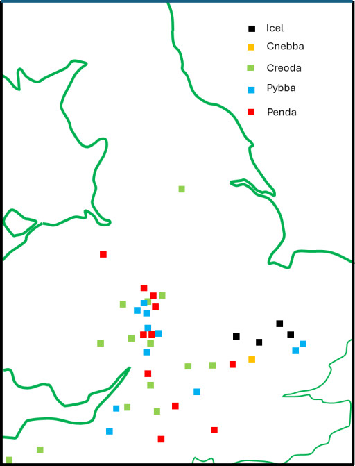
The early Mercian dynasty
The early kings of Mercia identified themselves as the Iclingas – the descendants of Icel. The early genealogies give their order as Icel, Cnebba, Cynewald, Creoda, Pybba and Penda, although there is much doubt about the veracity of the earlier names. However, Penda can confidently be placed in the early to mid seventh century. Counting back the generations, on the assumption that the list is vaguely reliable, puts the early names around the end of the fifth and beginning of the sixth century. Now Myers has pointed out that there are a series of place names in the Cambridgeshire / Suffolk area that can be associated with those of the early kings – Ickleford, Ickleton and Icklingham – and perhaps indicate a migration route. These are also shown on the map of Figure 1. However, it has long been known that there are clusters of place names in the Worcestershire / Gloucestershire area that are associated with the names of the later kings from Creoda onwards. These have been mapped by Jones (5), and a composite map for the kings up to Penda, redrawn from the data in Jones’ paper with some added information, is shown in Figure 2. The chronological procession from Suffolk and Cambridgeshire in the east to the West Midlands in the west is clear, and the clustering in the Worcestershire / Gloucestershire area is very striking. Despite the fact that these are Mercian kings, and early Mercia can be placed fairly confidently to the north in Staffordshire and Derbyshire, it seems that the kings from Creoda to Penda were closely associated with the region of the Hwicce.
Figure 2. Place names associated with the early Mercian kings (after Jones (5))
Synthesis
To sum up what has been written above, in the first half of the sixth century, there was a major movement of Anglo-Saxons (culturally if not ethnically) from the East Midlands to the West. The early ruling dynasty of Mercia was part of this, and place name evidence suggest that they were associated with the tribal area of the Hwicce in Worcestershire and Gloucestershire. Whilst the Hwicce seem to have migrated from the Rutland area, the dynasty of Icel seems to have migrated from somewhat further south in East Anglia. This does however bear on the third enigma outlined above. The fact that Creoda, Pybba and Penda had very close associations with the Hwicce area, could mean that later members of the dynasty regarded the territory of the Hwicce as their homeland of origin, and, by extension, Rutland came to be of ancestral importance for them. So my basic suggestion, which as ever is only really speculation, is that the later Mercian monarchs and their Wessex supporters and successors did all they could to keep Rutland from Danish settlement, not only because it was the dower land of their queens, but also because they regarded it as their place of origin, to which they had a significant historical, and perhaps emotional, attachment. Whatever price they paid to the Danes not to settle in the area was felt to be worth it to protect their (supposed) ancestral homeland.
The articles by Phythian-Adams (1977,1980) from several decades ago, and the more recent one by Green (2016) have highlighted the rather odd fact that within Rutland in the East Midlands, there are a number of place names that refer to the Hwicce, an Anglo-Saxon tribe whose territory was in the West Midlands, particularly in Worcestershire and Gloucestershire. In this short blog I firstly rehearse some of the findings of these authors and then extend the discussion somewhat, presenting some further, although tenuous, evidence of links between Rutland and the Hwicce based on consideration of the early Anglo-Saxon document known as the Tribal Hidage, and on estate holdings at the time of Domesday.
Place names
We begin by setting out the place name evidence as outlined by Phythian-Adams and Green. They showed that there are a number of place names in Rutland that strongly suggest an association with the Hwicce .These ae as follows.
Witchley Warren/Wicheley Heath – a farm in Edith Weston, but originally covering a significantly larger common area;
Withley East and Witchley West hundreds – the extensive area in the south of Rutland, that was included in the Northamptonshire Domesday;
The village of Whissendine in the north west of Rutland;
Witchley Leas on Whissendine parish.
In addition, around 20 miles to the south in Northamptonshire there is the parish of Whitson. A full discussion of these names, including their earlier forms is given in Green (2016) and their association with the name of the tribe of Hwicce is clear.
Topography and the Tribal Hidage
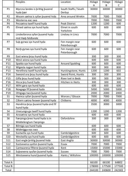
In an earlier blog I have shown that the current area of Rutland, plus the area around Stamford, matches fairly closely the catchment of the Upper Welland, whilst the catchment of the Glen, which joins the Welland below Stamford corresponds to at least the southern part of the Lincolnshire district of Kesteven. After the junction of the Glen and the Welland, the Welland flows towards Spalding – the territory of the early Anglo Saxon tribal grouping of the Spalde on the margins of Fenland . This was an extensively managed area, with well-defined common rights (Oosthuizen, 2017). In particular the control of water levels was vital to the pastoral economy, and thus the amount entering the area from the Welland was of crucial importance. This level of importance, and the fact that the two catchments of the river became well defined administrative areas, argues for their early definition as coherent units. Taking this further, I suggested that these land units corresponding to Kesteven and Rutland could be identified with the East and West Wixna of the Tribal Hidage (Hart, 1971), the first of 300 hides and the second of 600 hides, where the hide is an economic rather than a geographical measure. The reason for this assertion was that, in the listing of the Tribal Hidage these polities came between the Spalde and the South and North Gyrwa, which are known to be in the Peterborough area*. Although I am neither a linguistic nor a place name expert, it seems to me that the name of Wixna is also possibly associated with the name of Hwicce, and suggests that at the time of the production of the Tribal Hidage, which I take to be in the early seventh century following the argument of Higham(1995) at least part of the Hwiccan peoples populated the areas of Rutland and Kesteven.
*I also made the alternative suggestion that Rutland Kesteven could be identified with the East and West Willa, with names that are cognate with Welland, but on reflection I think their location in the list of the Tribal Hidage makes this less plausible.
Domesday and Queen Edith
It is well know that in 1066, Queen Edith, the wife of Edward the Confessor, held much of what was to become Rutland in Lordship, particularly in the southern Wycherley hundred, which was then part of Northamptonshire. However these were far from her only land holdings. The full extent of them is revealed through the analysis of the Open Domesday web site (Open Domesday, 2023), and shown on the map of Figure 1 below.
Figure 1. The Domesday holdings of Queen Edith (from Open Domesday)
The holdings where Edith was either Lord or Overlord, are shown by small red circles. There is a general dispersed group of holdings scattered across the north London / Oxford / Milton Keynes area, with further scattered holdings across the south Midlands. There are, however, a number of clusters. The Rutland cluster is indicated by the red circle labelled as A. The largest cluster is in the Herefordshire / Worcestershire area and is labelled B, with smaller clusters around Grantham (C) and Horncastle (D), with a further scatter across north Lincolnshire. Cluster B is of particular interest, as this lies in the western part of the territory of the Hwicce, which extends through Worcestershire and Gloucestershire. More specifically it lies within the territory of the Magonsaete, an early polity about which little is known (Pretty 1989), but which is sometimes referred to is referred to as the western Hecani – probably another name for Hwicce. Thus, we possibly have here another instance of Edith, as the Queen of England, and the successor of the Mercian Queens, as having much land in the predominantly Hwicce area, providing another link between the Hwiccan lands of Rutland and the larger Hwiccan kingdom in the west.
But what of the other clusters – can any Hwiccan connection be demonstrated between these and the Hwicce? Here the evidence is tenuous at best. The holdings around Grantham are in the Wapentake of Winnibriggs. This something of an odd name, and Coates (2009) would see it as a compound of a personal name and a bridge. I would make the very tentative suggestion however that this might be associated with the Hwicce, but this is very speculative. With regard to the Horncastle cluster, I can find no relationship at all with the Hwicce in terms of place names. For both however, it may be that historians of the locality may be able to identify any connection if it actually exists.
One further, tenuous connection exists between the Northampton shire village of Whitson mentioned above (which does have a Hwiccan association) with the isolated Queen Edith holding of Finedon. These are in the same area of the county, about 10 km apart. I will leave it to the judgement of the reader as to whether or not any weight should be placed on this.
References
Coates R (2009) “Reflections on some major Lincolnshire place names. Part Two: Ness wapentake to Yarborough”, Journal of the English Place Name Society, 41, 57-102
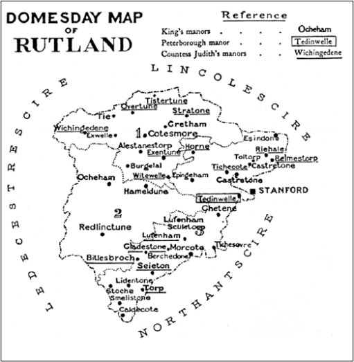
The study of local history is often a very personal affair. I recently moved from Lichfield to Oakham in Rutland, and have thus naturally become interested in the local history of the area, about which I previously knew very little. In particular the early, pre-Domesday, history of the area intrigues me. The nature of the now the county of Rutland in that period is far from clear. At Domesday in 1086 (1), it was divided between “Roteland” – the two northern wapentakes of Alstoe and Martinsley, which were recorded as a detached part of Nottinghamshire, and the southern hundred of Witchly, which was part of Northamptonshire (Figure 1 – from (2)). In a detailed study Phythian-Adams (3,4) argued that there was a deeper underlying unity and that Martinsley and most of Witchley formed the dower lands of late Anglo-Saxon queens, and possibly Mercian queens before that; and that a royal hunting forest stretched over these two regions. He hypothesized that the division of the region took place during the Viking period in the ninth and tenth centuries and this division was incorporated into the newly formed counties in the area in the late 10th and early 11th centuries. In addition, the whole region is also remarkably free from Danish place names, despite being firmly within the sphere of influence of the Five Boroughs of Lincoln, Nottingham, Derby, Leicester and Stamford, again suggesting a shared history of some sort.
Figure 1. Rutland at Domesday (from (2))
(1 indicates Alstoe Wapentake; 2 is Martinsley Wapentake, and the remaining area is Witchly Hundred.)
Be that as it may, Phythian-Adams was unable to make much headway into the origin of the land unit that was to become Rutland prior to the Danish invasions. He suggested that it might be a small polity similar to those listed in the area of Middle Anglia in the Tribal Hidage (5), that most enigmatic of documents that I have discussed elsewhere, but was unable to say any more. He also demonstrated that there were a number of settlement names on the western county boundary that could be interpreted as watchtower / beacon or something similar, suggesting a contested boundary with whatever polity lay to the west. In addition, he noted that where the Roman Road known as Ermine Street crossed the county boundary, there were significant Roman settlements at Great Casterton and Thistleton. Roman towns on boundaries seems to have been a characteristic of the Roman east midlands, possibly to control the boundaries of different tribal areas, which again suggests that the Rutland area had an identifiable identity at that period as a sub-region of the Corieltauvi tribal area.
In this blog post we revisit this issue of the early origin of Rutland through rather a different approach – by looking at the topography and river catchments of the area, and the interaction with the eastern fenland tribal areas that have been extensively studied by Oostthuizen (6). We will conclude that in these terms, the areas that were to become Rutland and the Lincolnshire “Part” of Kesteven formed two coherent neighbouring territories with rivers that drained into the highly managed fenland boundary and the polities of the Tribal Hidage that existed there and were important in maintaining the fenland habitat. In addition, a VERY speculative reanalysis of the Tribal Hidage gives two possibilities identifications of these territories.
Topography
Figure 2. The Welland catchment
Figure 2 shows a map of the catchment of the River Welland, produced by the Welland Valley Partnership (7). On it we have superimposed
the boundaries of the modern County of Rutland and the Lincolnshire area of Kesteven (dotted red lines)and the location of the town of Stamford (red circle);
the tentative boundary of the Tribal Hidage region of the Spalde (around Spalding) – Oostthuizen suggests that this represented by the hundred of Elloe in the Lincolnshire part of Holland.
The locations of the western “defensive” settlements mentioned above (green circles).
It can immediately be seen that the Martinsley and Witchly areas of Rutland, together with the area around Stamford, is effectively the area of the major part of the Upper Welland catchment and its tributaries, the Eye, the Chater and the Gwash, with the exception of a relatively narrow strip to the south of the Welland. The position of Stamford just outside Rutland in a narrow strip of Lincolnshire has frequently been noted as being anomalous, and consideration of a number of late Anglo-Saxon estate holdings suggest it was once part of the Rutland with significant estate links to the area. In topographic terms, the boundary between Rutland and Kesteven would make much more sense if it were to the east of Stamford. The defensive settlements can be seen to be at the upper end of the catchment, close to the watershed.
The area of Kesteven contains the catchment of the Glen that feeds into the Welland below Stamford. The Welland then feeds in to the fenland region of the Splade. This is of some significance. Oostthuizen shows that this area was heavily utilised for agriculture, with communal rights to use specific areas of the Fen for grazing. There are indications of the control of rivers and drainage channels in this and other fen boundary areas. This is of importance, as it implies that the Spalde would have every incentive to ensure some degree of control of the contents of the Welland and its tributaries, particularly in times of drought and flood, to ensure the productivity of their region. Thus, the two areas of Kesteven and Rutland would have been of some importance to the fenland economy of the Spalde, which points to the need for some sort of level of organization, either as separate polities, or as upland extensions of the territory of the Spalde, even if only with the status of a modern drainage authority. This in turn suggests that the origin of these two areas could arise from their topography as important catchments for the fenland economy. There is an anomaly here however – the wapentake of Alstoe is outside this catchment, with its streams flowing to the Soar and the Trent. Taken with the fact that this area was not part of the lands of the Anglo-Saxon queens, or of the Royal Forest, tends to suggest that it was not part of the original land unit.
But can we say any more about the nature and names of these two areas of Rutland and Kesteven? To that question we now turn.
The Tribal Hidage
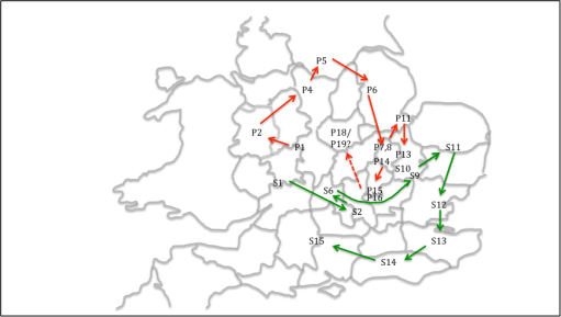
I have discussed the nature of the document known as the Tribal Hidage elsewhere – see here and here. Almost everything about this document is disputed in one way or another and great care needs to be taken in its interpretation and any conclusions that are drawn from it must be viewed with some circumspection. In its various versions, it consists of what was probably a Mercian or Northumbrian tribute list of various polities of a wide range of sizes (Table 1 reprinted from here), some of which can be identified and located, whilst the locations of others are disputed. It is arranged in two lists – a primary list and a secondary list, both, as far as can be judged proceeding a roughly clockwise direction (Figure 3 reprinted from here). Its date is as uncertain as any other aspect of the document, but for me the early date of around 620 proposed by Higham (8) seems the most logical.
Table 1 The Tribal Hidage
Figure 3. The order of the primary and secondary lists in the Tribal Hidage
Now in the primary list we have, at P7 and P8, the south and north Gyrwa. These can be located with some confidence in the Peterborough area, around the River Nene. The Spalde are at P11. Between The Gyrwa and the Spalde at P9 and P10 on the list, we have the East and West Wixna. These have not been located, with some writers placing them around Wisbech or the Norfolk edge of the fen to the east. However, their position in the list would suggest a location between the Gyrwa and the Spalde. As these two polities bordered each other, this is a bit tricky, but to identify them with Rutland and Kesteven is broadly consistent with the order of the list.
But there is another possibility. As mentioned above, the Tribal Hidage consists of two lists. In the Primary list, after the Hicca at P16, which can be located around Hitchen, there is the Whitgara. In the map of figure 3 I did not suggest a location for this. However, in the view of some scholars, such as Hart (5) this is an obvious reference to the Isle of Wight. In placing the unknown entities of P18 and P19 (Noxgaga and Ohtaga) in the Leicestershire / Northamptonshire area, I conveniently ignored this suggestion (on the basis that if some evidence doesn’t fit, it is best ignored – which I observe is a common practice of historians!). But if in fact the identification with the Isle of Wight is accepted, this means that the Primary list has two parts – the rotation round the north of Mercia, and then possibly three large entities in the south – Wight, Noxgaga and Ohtaga added on at the end. This would match with the suggestion of Hart who placed the latter two in the Surrey / London area. Pushing this line of reasoning a little further for the Secondary list, if this was again in two parts, we would have a rotation around the south and east of Mercia, and then a list of major subject kingdoms beginning with East Anglia running around the east and south of England. This in turn opens up the possibility of not having to consider placing S7 to S10 in the South Midlands in order to proceed from S6 (Faerpingas) in Oxfordshire to East Anglia (S11) in a reasonably logical way, but they could be allowed to be in the East Midlands where there is something of a hole on the map. Of particular interest are S9 and S10 – the East Willa and the West Willa. Hart places these in southern Cambridgeshire and argues that the name Willa is cognate with the name of the Well stream, a major waterway in the area. An identical argument could apply for polities next to the River Welland ie Rutland and Kesteven. However , the chain of assumptions is a long one, and this identification should be regarded as very speculative.
Concluding remarks
A consideration of the topography of the Welland Catchment, suggest that this may have been what defined the boundaries of what were to become Rutland and Kesteven. In the early Anglo-Saxon era, both these polities would have been important to the economy and agriculture of the Fenland boundary, and especially the region of the Spalde. In addition, it seems possible that we could identify Rutland and Kesteven with the Tribal Hidage polities of either the East and West Wixna, or the East and West Willa. Of these, the first two fit most naturally into the order of the Tribal Hidage, whilst the last two are most linguistically likely. But neither may be correct!
References
Thorn F (1980) “Rutland Domesday*”, Domesday Book 29, series editor John Morris
In the recently published book “Come wind, come weather” (Lichfield Press, 2021), Trevor James draws attention to the Midland Tornado of 1545 which caused very considerable damage along a very long storm track in Derbyshire. A description of the damage from that time is given in the Derbyshire edition of the Magna Britannia in 1817 and is reproduced below. In this short post, the nature of the storm will first be discussed and then we will make some estimates of the windspeeds that occurred, using modern damage scales. I will then address the question as to whether the event was actually a tornado, or some other type of wind storm.
The event
From the Magna Britannia.
” At Darbie the 25th daye of June 1545.
“Welbeloved sonne I recomend me unto you, gevyng you Godds blessyng & myne. Son this is to sertifie you of soche straunge newes, as that.hath of late chauns,ed in thes p’ties; that is to wytt, apon Satterday last past, being the 20th daye of this moneth, on Say’te Albons day, we had in thes p’tyes great tempest. … wether, about xi of the clok before none: & in the same tempest, The dev[ill] as we do suppose beganne in Nedewood, wch is ix myles from Da[rbie]; & there he caste downe a great substance of wood; & pulled up by the rotts: & from thens he came to Enwalle [Etwall] wher at one Mre Powret [Porte] dothe dwell, & he pulled downe ij great elmes, that there was a dossyn or xvj loode apon a piese of them; & went to the churche & pullyd up the leade, & flonge it apon a great elme that stondyth a payer of butt lenghthes from the churche, &. … it hangyd apon the bowys lyke stremars; & afte. …….. tourned. …… & the grounsells upwards & some layd bye apon. ….. heape &. ……. that was apon viij bayes long he set it a…….. gge & the. …… ro[ots] sett upwards; & he hathein the same towne lefte not past iiij or v housses hole. And from thence he came a myle a this syde, & there grewe opon Ix or iiijxx wyllowes, & apon xij or xvi he hathe brokyn in the mydds, & they were as great as a mans body: & so he lefte them lyke a yard and a half hye: And from thence he went to Langley, wch is lyke iiij myles from Darby, & there he hath pullyd downe a great p’te of the churche, & rowled up the leade & lefte it lyeing, & so went to Syr Wyllam Bassetts place in the same [towne] & all so rente it, & so pullyd a great parte of it downe wth his. …..& the wood that growethe abowte his place, & in his parke he pulled downe his pale & dryve out his deare, & pulled downe his woods, & so[me] broken in the mydds that was xvj or xx loode of wood of some one tre. And after that he went into the towne to Awstens housse of Potts & hath slayne his sonne & his ayer, & perused all the hole towne, that he hath left not past ij hole howsses in the same towne. And from thence he went to Wy’dley lane, & there a nourse satt wt ij chylderen uppon her lappe before the fyre, & there he flonge downe the sayde howse, & the woman fell forwards ap[on the] yongechyl[dren] afore the fyre, & a piese of ty’ber fell apon her. …… & so killed [her] but the chylderen were savyd, & no more hurte, [and none] of the house left standyng but the chymney, & there as the house stode, he flange a great tre, that there is viij or x lood of wood apon it. And from thence he went to Belyer [Belper] & there he hath pullyd & rent apon xl housses; & from thence he wente to Belyer [Belper] wood & he hathe pullyd downe a wonderous thyng of wood & kylled many bease; & from thens to Brege [Heage] & there hath he pulled downe the chappyl & the moste parte of the towne; & from thens to WynfeldmaJ that is the Erie of Shrowseberys [Wingfield Park], & in the parke he pulled him downe a lytell…… & from thens to Manfyld [Mansfield] in Shrewood & there I am sure he hath done [no] good, & as it is sayd he hathe donne moche hurte in Chesshire &….. shire. And as the noyse goeth of the people ther felle in some places hayle stons as great as a mans fyste, & some of them had prynts apon them lyke faces. This is trewe & no fables, there is moche more hurte done besyds, that were to moche to wryte, by the reporte of them that have sene it; and thus fare you well.”
James is persuaded that the account is genuine, not least by the mention of the damage to the chapel at Heage. The church at Heage was indeed officially a chapel (dependent upon another church) at the time and there are records elsewhere that indicate it was rebuilt after the storm. James quotes a further source (Warkworth’s Chronicle) which again suggests strong winds in Cheshire and Lancashire on that day.
The personification of the event as the “devil” is of interest and may reflect both the belief that such events were demonically rather than divinely inspired but might also refer to the name of such events – indeed even today small whirlwinds are referred to as dust-devils or something similar.
The description allows the track of the storm to be determined quite accurately, and this is shown on the map of figure below. In all the track where precise damage details are given seems to have been about 40 km long at least.
The track of the event. Purple lines indicate the boundary of Derbyshire and the purple circle is Derby itself. Red circles indicate the places where damage occurred, and green arrows indicate the storm track
Wind speeds
On the assumption that we are dealing with an tornado here, rather than another type of windstorm (see below), is it possible to obtain estimates of what the windspeeds actually were? Tornado windspeeds are usually estimated by inspecting the damage that they cause, and then using a damage classification method to determine the broad range of wind speeds that would cause that damage. Two methods are commonly used – the Enhanced Fujita (EF) scale developed in the US, and the T scale developed by the Tornado Research Association TORRO. Extracts from the damage descriptors are given below.
Enhanced Fujita EF Scale
EF2 49–60m/s Roofs torn off from well-constructed houses; foundations of frame homes shifted; mobile homes completely destroyed; large trees snapped or uprooted; light-object missiles generated; cars lifted off ground.
EF3 60-74m/s Entire stories of well-constructed houses destroyed; severe damage to large buildings such as shopping malls; trains overturned; trees debarked; heavy cars lifted off the ground and thrown; structures with weak foundations are badly damaged.
EF4 74-89m/sWell-constructed and whole frame houses completely leveled; some frame homes may be swept away; cars and other large objects thrown and small missiles generated.
TORRO T scale
T4 52 – 61m/s Motor cars levitated. Mobile homes airborne / destroyed; sheds airborne for considerable distances; entire roofs removed from some houses; roof timbers of stronger brick or stone houses completely exposed; gable ends torn away. Numerous trees uprooted or snapped.
T5 62- 72m/s Heavy motor vehicles levitated; more serious building damage than for T4, yet house walls usually remaining; the oldest, weakest buildings may collapse completely.
T6 73 – 83m/s Strongly built houses lose entire roofs and perhaps also a wall; windows broken on skyscrapers, more of the less-strong buildings collapse.
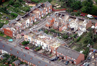
To give some context, the Birmingham Tornado of 2005 (pictured above), one of the strongest in recent years, was classified as a T5 event.
It is immediately clear that these descriptions are very subjective and the classification of damage into a particular class is not straightforward. It is perhaps less clear that each of these scales is to some extent culturally dependent. The EF scale reflects North American building and vehicle types, and the T scale reflects building and vehicle types from the UK in the 1970s when the scale was first produced. Neither reflects building practice in the 1540s and neither were there any cars to be lifted up in that period! Nonetheless, the description of 1545 can be used within these classifications at least in an approximate way. I would thus classify the 1545 event as borderline EF2 / EF3 or borderline T4/T5. These classifications give a wind speed range around 135 mph or 60 m/s. However, Neaden, in a study of tornado risk for the HSE, based on the above description, assigns a category of T6 to the event, giving a wind speed of at least 73m/s. This again illustrates the subjectivity of the classification.
The T scale also gives a classification based on path length
T4 2.2 to 4.6km
T5 4.7 to 9.9km
T6 10 to 21km
T7 22 to 46km
On the basis of path length Neaden again gives a T6 classification, although the length as shown in figure 1 suggests a T7 classification. My view would be that the event should properly be categorised as EF2/EF3 or T4/T5 with an unusually long path length but the subjectivity of this assessment must again be emphasised.
Was it a tornado?
The question that then needs to be addressed is whether or not the 1545 event was a tornado or some other storm type – presumably one of the usual extra-tropical cyclones that pass across the UK quite frequently. Even in such storms there are known to be smaller tracks of major damage. In the 1987 storm for example there was a swathe of extreme damage to trees in a arc a few miles wide across the south of England. This was attributed to a high-level jet of wind sweeping down to ground level – a phenomenon know as a “sting jet” because of the scorpion tail-like cloud formation with which such events are often associated.
The points that suggest the event was a tornado are firstly the existence of a coherent storm track, albeit significantly longer than would normally be the case, and secondly the fact that the event occurred in June, when extra-tropical cyclones are uncommon but tornadoes are. On the other hand, the point that suggest the damage was due to an extra-tropical cyclone is the reference in more than one source to concurrent strong winds in Cheshire and Lancashire. Indeed, wind speeds of 60 m/s have been measured in extra-tropical cyclones in the past – for the 1987 Burns Night storm for example the peak wind speed was somewhere around this value.
Referring again to the work of Neaden, his data indicates that between 1800 and 1985 there were around 10 tornadoes with a classification of T5 or higher in Derbyshire. This indicates that one would occur on average every 20 years or so. One would expect that most of these would have path lengths of a few kilometres and thus the effects would be localised – and in a rural county like Derbyshire not much damage might be recorded.
Now, one might expect that an extra-tropical cyclone with wind speeds of the order of 60m/s would only occur in lowland Britain once every 200 to 300 years – indeed the 1987 storm was assessed as having this return period. Thus they are very rare events indeed.
A comparison of the likelihoods of a T5 tornado and an extra-tropical storm with the same windspeeds thus suggests to me that it is most likely that the 1545 event was indeed a tornado with an EF2 / EF3 or T4/T5 classification, albeit with an unusually long storm track, but also that it was quite possibly embedded in a larger extra-tropical cyclone of some strength. However, as with any other historical phenomenon of this type, absolute certainty as to its cause is of course not possible.
In coming to a the definition of the Original Mercia outlined in “The first Mercian Lands”, I included Seisdon Hundred in south Staffordshire within its bounds (figure 1). The reason for doing so was primarily because this area became part of the Mercian Diocese of Lichfield. However there is some rather disparate evidence that at least part of Seisdon hundred was Hwiccan territory at some stage before the formation of the diocese.
Topographically, the area is in the catchment of the Smestow and Stour and thus of the Severn itself, as is the case for the other Hwiccan territories. Other parts of Staffordshire are in the Trent catchment.
There are Domesday linkages between the manors of Tardebigge and Clent in Worcestershire and Kingswinford in Staffordshire – and indeed Clent was for many centuries post-Domesday an island of Staffordshire within Worcestershire.
The manors of Kingswinford and Amblecote (in Staffordshire) and Oldswinford (in Worcestershire) were almost certainly once part of the same land unit.
The ecclesiastical parish of Oldswinford was split between the manors of Oldswinford in Worcestershire and Amblecote in Staffordshire.
The large Worcestershire enclave of Dudley has been surrounded by Staffordshire since the Domesday survey.
The name of the Hundred itself is taken from the village name of Seisdon, which can plausibly be translated as the Hill of the Saxons. This ties in with the now rather dated assumption that the Hwicce represent the northward advance of Saxons up the Severn valley.
Thus a case can be made that the area of Seisdon Hundred was originally Hwiccan territory that was absorbed into the Original Mercia. The reason for this is clear from the map of figure 1 – strategically it is a very important area. The Roman road system centred on Greensforge controls access along the Saltway from Droitwich to the north, access to Shropshire, the borders and Wales, and gives a direct link to Quatford on the Severn, allowing control of river traffic. Three potential roads are shown on the map that are not shown on the larger scale map of figure 8 in the main text – those from Greensforge north east to Wall, from Water Eaton to Metchley and from Metchley to Greensforge. The routes of the first two can be traced in places on the ground (Horovitz, 2005; Bassett, 2001), but the lines shown on the map are purely conjectural. It is however likely that the two routes crossed at Wednesbury. The route between Metchley and Greensforge (Baker, 2013) begins with the Metchley to Water Eaton route but branches from it through the village known as the Portway near Oldbury and then passing though, or to the south of Dudely, to Kingswinford and Greensforge. Taken together this road network clearly adds to the connectivity of the region and emphasises its strategic importance.
Figure 1 – Seisdon Hundred
(Red shows boundary of the hundred – a solid line where it coincides with the county boundary, and a dotted line otherwise; grey shows other county and hundred boundaries; brown shows the pre-1974 county boundary, reflecting the early post-Domesday losses to Shropshire; roads are shown (schematically) in green and rivers in blue).
On the page “The first Mercian Lands”, 1 have drawn on information in the document known as the Tribal Hidage, as part of the investigation into the location of the original Mercian lands. In this short note, I consider this document in a little more detail. Table 1 above gives a summary of the three separate recensions of the Tribal Hidage. The description of the polities from Recension A is given, together with the location where there is general scholarly agreement. As noted in the main text, there are two combined lists – Primary (P) and Secondary (S). The Hidages from the three recensions are then also given. It can be seen that these vary somewhat. The sum of the hidages in all three recensions is given for both lists A and B. In Recension A, a false total is given for the total hidage of 242,700.
Figure 1. Tribal Hidage. “Firm” locations of regions in the primary and secondary lists (figure 3 in main text)
It was noted on “The first Mercian Lands” that the clockwise ordering of the primary and secondary lists seems to be a very deliberate tactic on behalf of the original compiler of the list – see figure 1 above. At the risk of pushing this schema too far, it is worth asking the question if the location of the polities whose locations are not known can be inferred by imposing this clockwise presentation scheme. Thus let us consider those polities in table 1 where no location is given.
Westerna (P3). Scholars usually identify this as one of the Magonsaete in south Shropshire / Herefordshire, somewhere in Wales, or the region around Chesire. Higham would see it as representing the tribute payment of the Welsh Overkingship from somewhere in Gwynedd. It does not seem to the author that the Magonsate is a possibility as this kingdom seems to have been established late in the 7thcentury i.e. after the Tribal Hidage was compiled. The clockwise rotation would best place this polity in Wales or the Cheshire region. My preference would be to see it as the Western half of the Civitas of the Cornovii that was ultimately to become the kingdom of Powys, which fits best with both the name and the clockwise rotation.
East and West Wixna (P9 and P10). Within the Fenland there seems to be a subsiduary clockwise rotation, at least based on those polities identified by Oosthuizen. If this is the case then the East and West Wixna would lie somewhere on the Fenland margin between the Gwyre and the Spalda. This is not however consistent Oosthuizen’s analysis.
Wigesta (P12). The clockwise rotation within the fens would place this to the south and west of the Spalda.
Wiht gara (P17). This is taken by most scholars to be the Isle of Wight. The present author finds this very difficult to believe, as it lies within the primary list, but is separated from all the other polities in that list by those in the secondary list. In the author’s view this probably represents a typographical error, with the original name being confused for the (more familiar) name for the Isle of Wight. The clockwise rotation would see this region in the Bedfordshire area.
Noxgaga (P18) and Ohtgaga (P19).It has already been argued on “The first Mercain Lnds”, that the clockwise rotation places these two sizeable entities in the Northanptonshire /Leicestershire area.
Hendrica (S3).The Ciltern sætna and Hendrica together have an assessment of 7000 or 7500, suggesting they are subdivisions of one unit. If so this would obviously place the Hendrica in the Chilterns area, which is consistent with the clockwise rotation of the secondary list.
Unecunga-ga (S4).This name is clearly corrupt and no convincing location seems to have been proposed. Again, the clockwise rotation would suggest that it be placed somewhere in the Oxfordshire area.
Arosætna (S5). Conventionally, this polity is identified as being in the valley of the River Arrow in Worcestershire and Warwickshire. However there is no indication elsewhere that this area was ever anything other than part of the Hwicce, and I find it difficult to accept this identification. The clockwise rotation would again suggest that this be placed somewhere in the Oxfordshire region.
Bilmiga (S7) and Widerigga (S8). Various locations have been suggested for these entities, including the area of Lincolnshire to the west of the Wash, and regions in Eastern Northamptonshire. Both these suggestions however cut across the boundary between primary and secondary lists i.e. between the Midlands and Southern Overkingships. The clockwise rotation would see them best placed in the south Midlands area perhaps in Buckinghamshire or Hertfordshire.
It has been noted above that the hidage values are generally expressed in terms of a duodecimal system for the smaller polities, and in units of 7000 for the middle sized polities. The larger kingdoms seem to have punitive assessments of 30,000 or 100,000. One must approach these numbers with a very great deal of caution and be very wary of giving them too great a significance. In an early study of the Tribal Hidage,Russell (1947)give an interpretation of the significance of the numbers in a tour de force of somewhat dubious arithmetic and remarkable assumptions of copyists errors to show hidden additions and totals throughout the list. What he actually demonstrates is the remarkable flexibility of the duodecimal system to provide all sorts of totals and subtotals from any subset of numbers. However there are perhaps two numbers that do have some significance – the figure of close to 36000 of the primary list of the Tribal Hidage (excluding the original Mercia), and the approximate 144,000 total of the primary and secondary lists excluding Wessex. Both these numbers have rich biblical symbolic meanings, which would have been well appreciated by later copyists, and in particular latter might be thought to emphasize the totality of the tribute being paid by the Midlands and Southern overkingships. These numbers are not of course exact, but there is perhaps some indication that those who later edited the lists attempted to make the additions more precise. For example Recension C removes a 100 hides from the 900 for the Wigesta, which would reduce the overall total for the primary list (excluding the original Mercia) to 36,000 – although he also removes 600 from the Pecsaete and 598 (!) from the Herefina, which destroys this calculation. A similar change of 100 hides would also bring the overall total for the two lists to 144,000 (excluding Wessex), although this is again obscured by other minor changes (which are possibly copyists errors). It is not argued here that the numbers in the list should be seen as having any particular significance – but rather that later editors and compilers thought that this might be the case and tried to make them fit to what they believed were appropriate numbers.