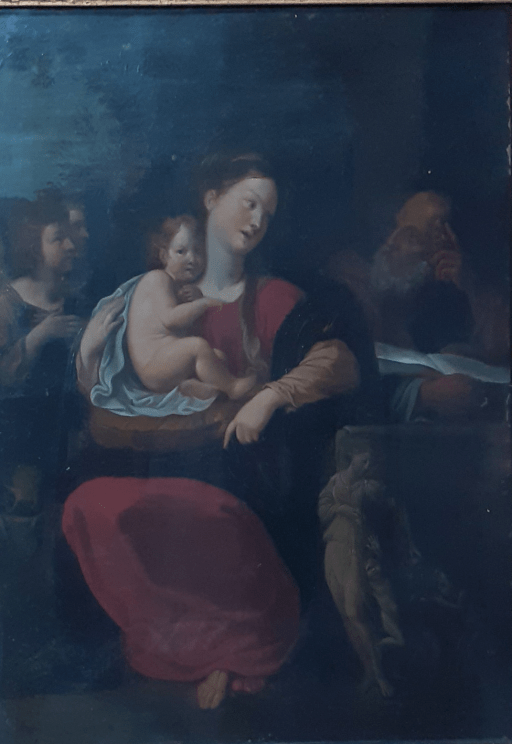
The painting of the Holy Family shown below has hung in the Vicar’s Vestry at All Saints church in Oakham for many years, and has, until recently, never been properly identified. Recent expert advice suggests it is a late 18th / early 19th century copy of a composition by Francesco Albani of between 1608 and 1610. It is believed that it was produced by a workshop in Italy, or perhaps the Netherlands, to satisfy the demands of those on the “Grand Tour” for devotional works. Whilst thus not of any great value, it thus does have an interesting back story.
After a composition by Francesco Albani, paint on metal, late 17th / early 18th century
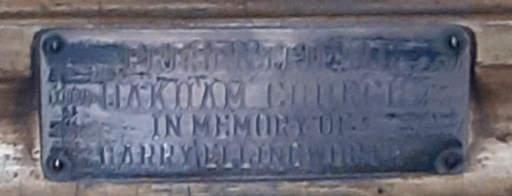
It’s detailed provenance is not known, but a difficult to read caption on the painting frame (below) has the inscription
“Presented to Oakham Church in memory of Harry Ellingworth”.
The Ellingworth family were prosperous shopkeepers in Oakham in the late 19th and early 20th century, and a number of them were named Harry. The most significant of these seems to have been a Harry Ellingworth who was a Town Crier in Oakham in 1881.
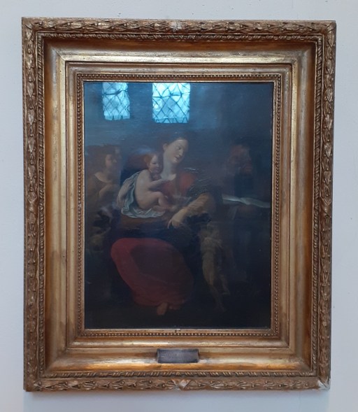
Painting in frame (with window reflections)
Dedication label
Interestingly a number of similar copies of the painting can be traced – either painted in Albani’s workshop or elsewhere (see below). The details vary, but the basic composition is the same. The market for such paintings was clearly buoyant.
Print of the original by Francesco Albani housed in the Museum of Fine Arts in Boston. 1608-1610
Dulwich Art Gallery Holy Family by Studio of Francesco Albani 1610-60
The painting shows a somewhat weary and pensive looking Madonna in a red dress with a dark blue shawl, The Christ child sits on a golden cushion on her lap, partly surrounded by a blue sheet. Joseph looks on from the right, with an open book in front of him, that seems to be placed on a stone chest or altar or perhaps a tomb. It may be that the directions in which the Madonna and her husband are pointing is of some iconographic significance – Joseph, in his contemplation of scripture pointing upwards to God, and Mary, with the Christ child on her lap, pointing down to earth, the direction, if that is an appropriate word, of the incarnation. Two angelic figures look on from the left. There is a figure carved on the stone chest, that, from the original, appears to be some sort of Bachannalia, with wine being poured out for small dancing child like figures. Again there may be some iconographic significance here with a representation of Christ’s blood being poured out at the Eucharist. The mixture of biblical and classical themese seems to have been common at the period of the original composition.
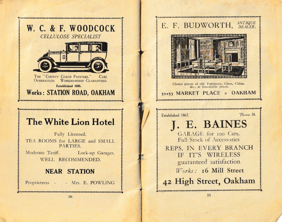
Recently I have come across a number of old Church Guides and Histories for All Saints Church in Oakham- from 1932, 1972 and 1980. PDFS of these can be found on the History and Heritage page of the church website. There comes a time of course when old guides and histories become historical documents in their own right, revealing how the church was thought of and communicated at the time of writing, and in their description of their contemporary activities, give an indication of the nature of the church’s worship and other activities. This is particularly true of the 1932 guide – The Story of Oakham Church, School and Castle by the then vicar, A. Edward Fraser. In what follows I post just a few pages from this this guide – the adverts it contained for local businesses that paid for its publication. These are given below, and I suspect that Oakham readers will find them of considerable interest.
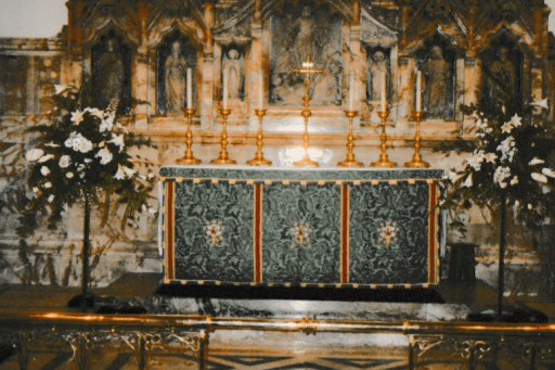
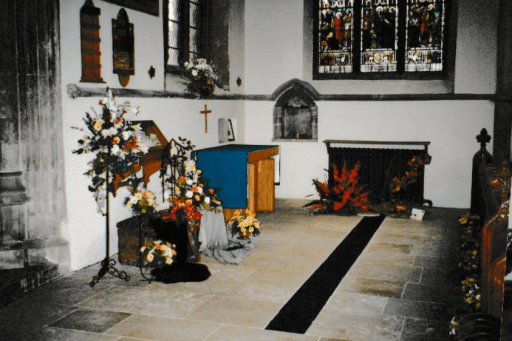
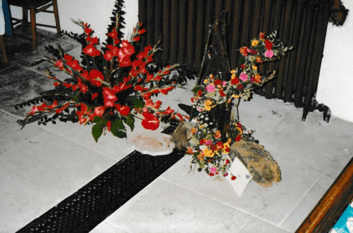
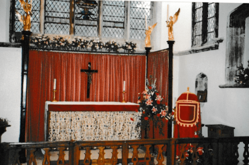
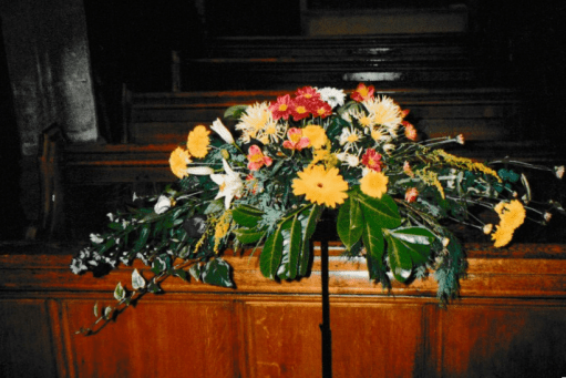
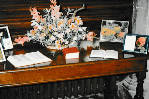
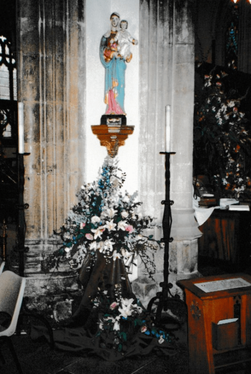
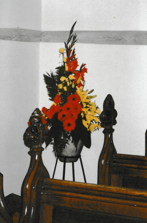
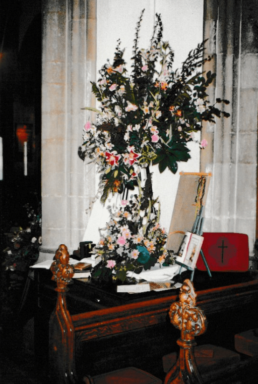
In 1996, All Saints church in Oakham, organised a flower festival. Some photographs from this event were deposited in the church safe for safe keeping, and I have recently come across these whilst searching the safe for other items. It seems to me that these photos are well worth sharing – both for the flower displays but also for the glimpse they give of the church from 30 years ago. Pleas click on the photos below for larger versions of the pictures. The colours aren’t marvellous – they can only be as good as the prints – but they will be of interest to some.
Holy Trinity ChapelHoly Trinity ChapelNorth TranseptHigh altarSouth TranseptSouth TranseptSouth TranseptLady ChapelLady ChapelArea near north doorCentral CrossingCEntral CrossingNorth TranseptNear pulpitEntrance to Lady ChapelWest End
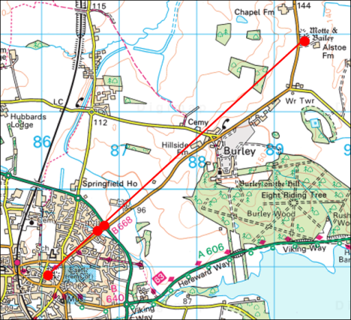
In a post “A possible Anglo-Saxon church group at Oakham in Rutland” from May 2024, I noted that All Saints Church in Oakham, and Our Lady’s Well to the north east were on what could be a mid-summer sunrise / mid-winter sunset solar alignment. I went no further than simply noting this, and didn’t speculate further about what it might imply. One always needs to be cautious about such alignments – they can be simple coincidences, and, if they are being looked for, can be found in the most unlikely places. For example from Borrowcop Hill in Lichfield, possibly an ancient burial mound, there was until recently a perfect alignment with the medieval spires of Lichfield Cathedral and the cooling towers of Rugeley power station, the latter sadly now demolished, which can hardly be of ancient origin. That being said, a reader of the May 2024 post sent me some further information that suggests that a cluster of Stone Age / Bronze Age / Iron Age remains have been found to the north east of Our Lady’s well that could also be on the same alignment. Looking at this further, I realised that several kilometres to the north east of that, and again on much the same alignment, we have Alstoe Mount, another historic monument. These are all shown on the Ordnance Survey map extract of Figure 1 below. The nature of this possible alignment, along the axis of the mid-summer sunrise and mid-winter sunset is discussed further in this post.
Figure 1. The possible alignment. The sites are shown as red circles – from the south west to the north east these are All Saints church in Oakham, Our Lady’s Well, the historic monuments and Alstoe Mount.
The sites
All Saints church, Oakham
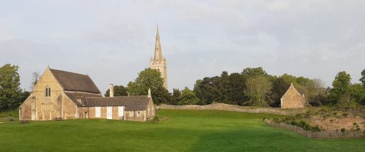
All Saints Church is Oakham (Figure 2) is a twelfth century church with thirteenth to fifteenth century additions. Internally it is pure Victorian, having been restored by Gilbert Scott. However it almost certainly stands on the site of an Anglo-Saxon church, and a church in Oakham is mentioned in the Domesday book. A compendium of historical information is given on the church website.
Figure 2. All Saints Oakham and Oakham Castle (photograph by the author)
Our Lady’s Well
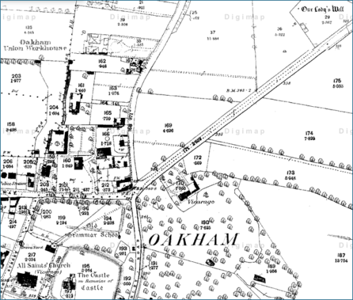
Our Lady’s Well is a historically well-attested pilgrim site to the north east of All Saints church – see Figure 3. To quote from Leicestershire and Rutland’s Holy Wells by Bob Trubshaw from 2004;
Our Lady’s Well was once famed for curing sore eyes – providing that a pin was thrown in first. In 1291 indulgences could be obtained by visiting Oakham Church during its patronal festival and, for a price, joining a pilgrimage to Our Lady’s Well. In 1881 it was visited by the future Queen Alexandra. The well is to the north-east of the town, in a somewhat overgrown area between the Cottesmore road and a modern housing estate (NGR SK:866095).
It’s current condition is no better, and it is now impossible to access the well, in an overgrown plot of wasteland, which seems a shame.
Figure 3. Location of Our Lady’s Well from the 1880 Ordnance survey Map (All Saints church is at the bottom left, and the well at the top right.)
The Stone Age / Bronze Age / Iron Age monuments
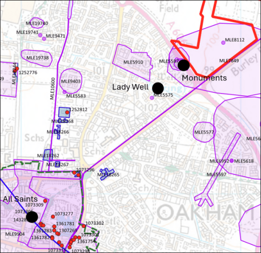
The material I was sent concerning the Stone Age / Bronze Age / Iron Age monuments came from “Land off Burley Road Oakham, Vision and Delivery Document” produced by Pigeon Investment Management with regard to a proposed hosing development. Figure 4 is taken from that document and shows the location of Our Lady’s Well and the relevant monuments.
The monuments are listed as follows, where the numbers are those on the Historic England National Heritage list.
MLE5587 – Possible Mesolithic site west of Burley Road MLE5592 – Late Iron Age/Roman site west of Burley Road MLE5593 – Bronze Age burial, west of Burley Road MLE5594 – Neolithic pit circle site west of Burley Road
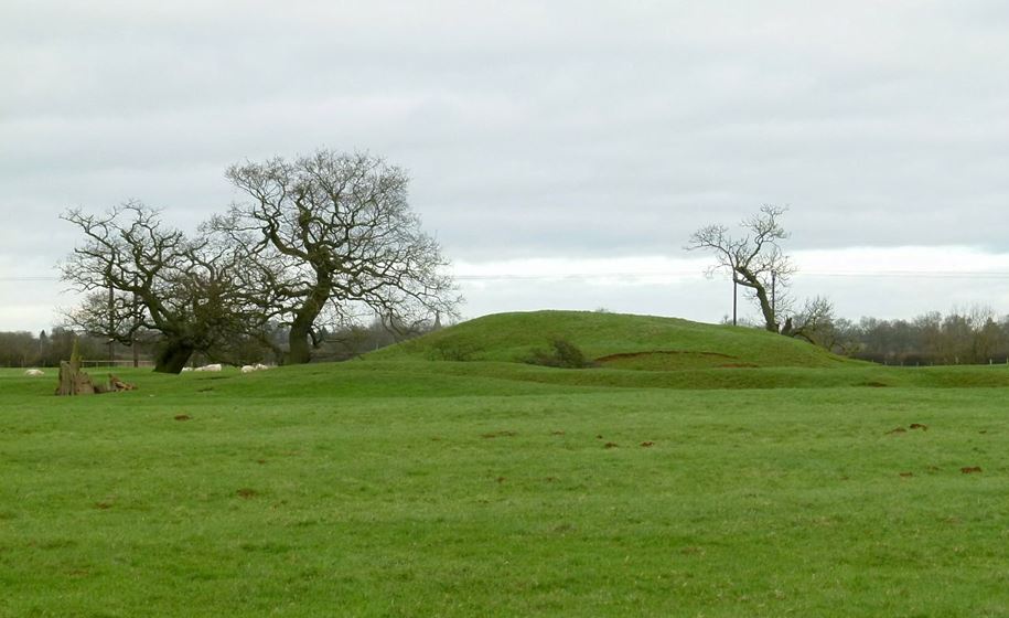
Alstoe Mount
The substantial mound of Alstoe Mount (Figure 5) is described on the Ordnance Survey map as a Motte and Bailey. That is almost certainly not true. It was probably the Moot location for Alstoe Hundred. Details of the mound and the surrounding deserted village are given in the Historic England list entry.
Figure 5. Alstoe Mount (photograph from Historic England by Alan Murray-Rust, 2016)
The possible solar alignment
A current mid-summer sunrise / midwinter sunset direction from Oakham is 47.5 degrees east of north (from SunCalc). However obtaining a precise value to compare with the possible alignment shown in Figure 1 is difficult for two reasons. Firstly the actual direction of sunrise and sunset has varied over the millennia – and as things stand, we have no date for which a calculation can be made. This change is however small – of the order of 0.2 to 0.5 degrees. Also the apparent direction from any point depends upon the precise topography of the horizon over which the sunrise / sunset is observed – and as we know nothing about the observation point or the direction of observation, this is again not possible to specify. This again results in an uncertainty of around 0.5 degrees. So all we can probably say is that we are looking for an alignment of 47.5 +/-1.0 degrees east of north.
The actual directions between All Saints Oakham and the other sites is as follows.
Oakham to Our Lady’s Well – 46.3 degrees Oakham to Stone Age / Bronze Age / Iron Age monuments – 47.1 degrees Oakham to Alstoe Mount – 47.8 degrees
Again there is uncertainty here – particularly in the specification of the precise site at Our Lady’s Well of any structure that might have been visible from All Saints, and similarly the precise position of any relevant structure in the monument field. The location point for All Saints (taken as the centre of the building) could be around 10m to the east or west. This can have an effect of the bearings of Our Lady’s Well and the monuments by around 0.25 degrees. Considering these uncertainties the above bearings and a sunrise / sunset direction of 47.5 degrees seem broadly consistent, and thus there does seem to be some evidence for all four sites lying along a solar alignment of some significance.
But there is another issue – that of elevation. A cross section along the proposed alignment is shown in Figure 6. From this it is clear that Alstoe Mount would not be visible from Our Lady’s Well or from the Monument field, and would only just be visible from All Saints if any observation platforms that existed there and at Alstoe were raised off the ground by a metre or so. Beacons however would have been visible.
Figure 6. Section through the proposed alignment (from Google Earth Pro.).
Discussion
So what does the above analysis lead to. Firstly I think there is plausible (but far from conclusive) evidence for a mid-summer sunrise / mid-winter sunset alignment, at least between the Monument field / Our Lady’s Well and All Saints, and possibly between Alstoe Mount and All Saints. but the available evidence gives us no chronological information as to when the alignment might have been of significance. Our Lady’s Well is first mentioned in the late Middle Ages and All Saints and Alstoe Mount can only be said to become of important in the pre-conquest period. There is no evidence at all, except in the monument field, for the other sites being important in the Stone Age / Bronze Age / Iron Age. So in my view it is probably better to stop at this point – acknowledging that there may be a solar alignment, but not taking speculation any further. The boring, cautious approach I guess, but I don’t think there is much more to be said.
Some summer reading and viewing – a compilation of some of my recent blog posts and a presentation on the history and heritage of All Saints church in Oakham.
Blog posts
The memorials of All Saints Oakham. Photographs and brief descriptions of the wall mounted memorials at All Saints church in Oakham (May 19th 2025)
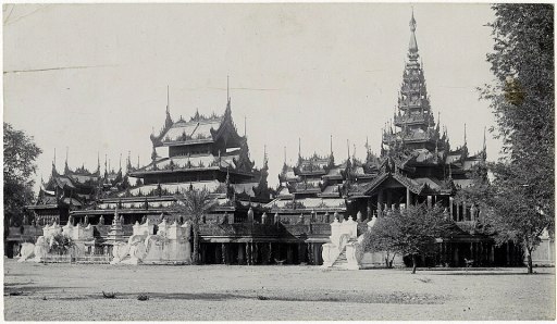
From Oakham to Mandalay. The story of a young curate from Oakham and his brief service as a missionary in Burma before his early death (April 29th 2025)
Kinetic Water Power – some odd words on a memorial in All Saints Oakham led to some interesting findings about how church organs were powered at the start of the 20th century (25th April 2025)
The 1858 Restoration of All Saints church in Oakham. Part 1, Part 2,Part 3 Three linked posts giving the transcripts of press reports of the restoration and re-opening of All Saints church in 1858, including the condition report by Gilbert Scott (October 9th 2024)
A time to mourn and a time to dance. A time to mourn and a time to dance – the All Saints season through the ages. The video of a talk given at All Saints Oakham on October 31st 2024
For some summer reading – a compilation of some of my recent blog posts on ancient and more modern Oakham and Rutland history.
The street topography of early Oakham. A post that considers how the street of Oakham and the surrounding areas might have been configured in the Anglo-Saxon and Norman periods (December 8th 2024)
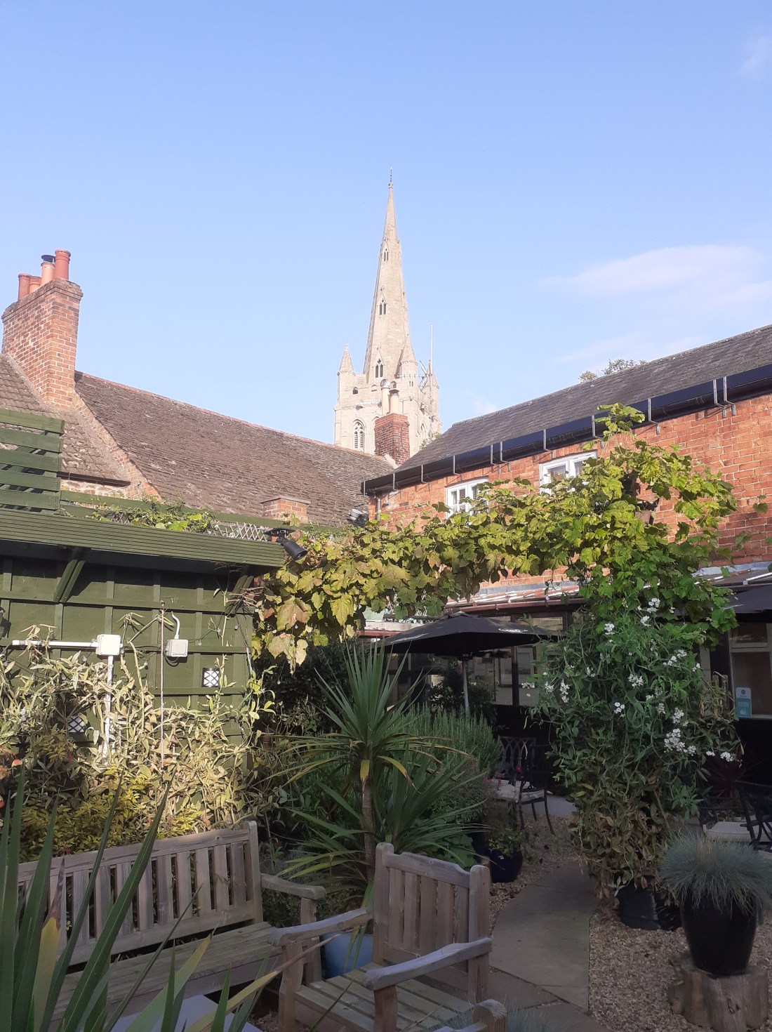
Oakham roofs. A photo blog simply showing the upper floors and roofs of the buildings on the north side of the High Street in Oakham. For no other reason than I like roofs. The history is implicit rather than explicit (July 23rd 2024)
Rutland – an enigmatic history – a further speculative consideration of three oddities about the early history of Rutland (2nd February 2024)
Rutland and the Hwicce Some further thoughts on the County of Rutland and its association with the Hwiccan tribe of Worcestershire and Gloucestershire (30th December 2023)
The Origin of Rutland – some speculations on the early history of the area where I now live (2nd December 2023)
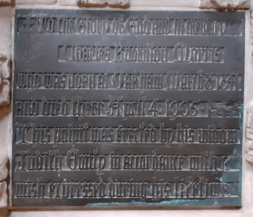
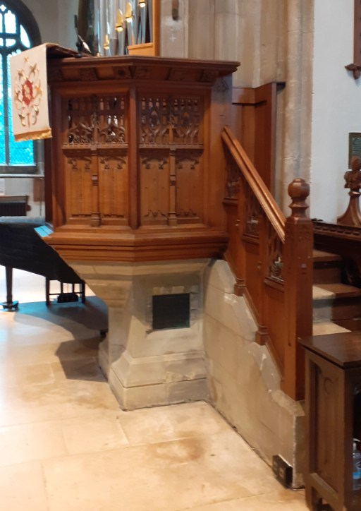
Memorials in churches can be in some really odd places. I recently noticed a brass plaque almost at ground level on the base of the pulpit at All Saints in Oakham. Even sitting on the floor in close proximity I was unable to make out much of it, but by taking some photographs and enhancing the contrast, I was able to get the image on the right. This reads
To the Glory of god and in remembrance of Charles Knowlton Morris, who was born at Oakham March 18 1841 and died there April 4 1905. This pulpit was erected by his widow Judith Emily in accordance with his wish expressed during his lifetime.
Pulpit memorial tablet
The name rang a bell in my mind – there is a very similar dedication on the stained glass window in the south transept.
To the glory of God and in remembrance of Charles Knowlton Morris who was born at Oakham 8th March 1841 and died there 4th April 1905. This memorial is erected by his widow Judith Emily.
Window memorial dedication
Charles Knowlton Morris
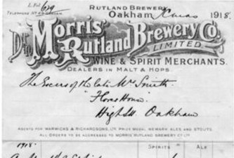
So who was this Charles Knowlton Morris? He turned out to be quite easy to trace through the historical record. He was born in 1841, the son of Clarke and Francis Morris (nee Hare) of Catmose Street in Oakham, one of at least six children. Clarke Morris was a brewer in Northgate in Oakham. Two of his sons – William Clarke Morris and Charles Knowlton Morris took over the business after Clarke’s death in 1857. The brewery moved to Cross St / New St in 1866 and in censuses and trade directories, the business is usually described as Morris’ Rutland Brewery, and they were also listed as coal, salt and seed merchants at the railway station wharf. William Clark died in 1895 and it appears that the business passed directly to his brother. The Reredos and Marble flooring in the chancel at All Saints were donated by Charles in memory of his brother in 1898.
All Saints Reredos
Reredos dedication plate
Charles married late in life, in 1898 aged 57 to Judith Emily Tiptaft, the daughter of a Northamptonshire farmer, who was seventeen years his junior. There were no children. Charles died on 4/4/1905, leaving a very considerable business and effects worth £19448. The business was sold off by auction fairly soon after his death. It is described in the Grantham Journal of 25/11/1905 as consisting of the brewery in New Street, and nineteen public houses in Oakham and the surrounding area. Those in Oakham included the Railway Hotel on Station Road, the Roebuck Inn on Church Street, the Bell Inn on Catmose Street, the Royal Duke Inn on West Road, Oakham, the Angel Inn on Northgate Street, and two off licenses, the Rutland Arms in New St and the Britannia Inn on Northgate Street. The estate was bought for £28,250 by Warwicks & Richardsons Ltd, Newark. Brewing ceased in 1907, but Warwicks continued to use the name Morris Rutland Brewery on Guiness bottled in Newark until 1962.
Comapny banner
The Brewery in New St in 1980
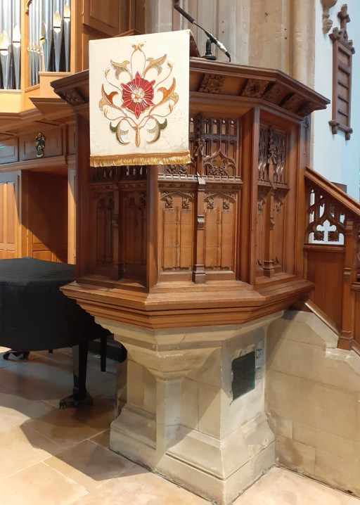
The dedication service
On 6/9/1896 at a service at All Saints church in Oakham, a new pulpit and stained glass window were dedicated to the memory of Charles. These are described at length in the Grantham Journal of 8/9/1906 as follows.
The window composed of three long lights, surmounted by beautiful tracery, and is now the best of the many fine windows in this Church. The stained-glass design is governed by the architectural features, which are typical 14th century work, demanding small subjects and canopies. The subjects are nine in number, massed in rich deep colours, all contributing to the design of three bands running laterally through the tall lights in the window, and are set off by the intercepting canopies, which are soft, and display a silvery effect. Incidents in the life of our Lord with which all are familiar are represented, and portray, respectively, ” Endurance,” “Love,” ” Fortitude,” “Humility*,” “Principle,” “Charity,” ” Innocence,” Sympathy,” and “Justice.” These help to illustrate, in their appropriateness, the beautiful life of Charles Knowlton Morris, whose memory they will perpetuated.…..……. Flowers and birds are delicately introduced as emblems, and the Past Masters’ jewel .and badge of the Vale of Catmos Lodge (No. 1265) of Freemasons are shown a small shield at the foot of the centre light.
The apex of the window contains the dove, and rays emanate from it into the surrounding side lights, and disappear behind the finials of the canopy, which runs out from main design below. The window was designed and executed by Mr. Dudley Forsyth, 335, Finchley-road, Hampstead, London
The new pulpit, as detailed on the inscription panel at fulfils wish expressed by the late Mr. Morris during his lifetime. It is in the Gothic style, and has been carefully designed so as to harmonise with its surroundings. The steps and the stone base by which the pulpit is supported are green Chilmark stone. A large moulded corbel, springing from the base, carries the pulpit, which is, in shape, five sides octagon. The material used is Austrian oak, slightly tongued, in order that it may resemble the existing oak fittings in the Church. Each side of the octagon is divided into two panels, the lower part of each carved, the upper part pierced; and care has been taken vary the design of the carving, as avoid monotony and give interest work. The cornice which crowns the pulpit is variously carved to represent the of the Passion of our Lord. The balustrade to the steps is similarly treated panels, and the whole, including the brass memorial tablet, reading-desk, and black fittings, has been designed Messrs. Forsyth and Maale, architects, of London, and carried out for the pulpit by J. P. White, of Bedford, and for metal work by Messrs. J. Elsley, of London.
Later years
Judith Morris must have spent a considerable part of her inheritance on these monuments to her husband. She was later to marry Dr Henry Drew in London in 1922. She died in 1945 at the age of 87. Pictures are available of her here and here, although an Ancestry subscription will be required to access these.
After her death in 1945 we read in the Leicester Evening Mail of 16/3/1945
Under the will of the late Mr. Charles Knowlton Morris, a former Oakham brewer, the vicar and churchwardens of Oakham receive a legacy, following the death of his widow, Mrs, Judith Emily Drew. of Leadenham House, Braunston Road. Oakham, to provide pensions for members of the Church of England. The sum is £3O annually. to provide three £l0 pensions for three poor persons of good character of the age of 85 and upwards residing in the town, and being members of the Church. It will be called the “Morris Gift.”
So it can be seen that much of what can now be seen at the “business” end of the church – around the altar where the Eucharist is celebrated, and the pulpit where sermons are preached was donated by the Morris family. Now the late 19th century was a time when the Teetotaller movement was very strong in reaction to the obvious ill effects of excess alcohol consumption, mainly on the poor. But clearly the Church of England in Oakham had no scruples about accepted considerable donations from a brewer. But, even in this more moderate age (at least in terms of alcohol consumption) the fact that Sunday services take place on structures funded by the receipts of nineteen public houses in Rutland might manage to raise a few eyebrows.
All Saints Church in Oakham is a long term supporter of the Church Mission Society (CMS). It has recently been allocated two new mission partners, both working in Myanmar (formerly Burma). CMS have requested that the church does not publicise these links, as the partners work in a dangerous and sensitive situation. Nonetheless we pray for them and support them as best we can.
Very recently, after a service of Morning Prayer in which the mission partners were remembered, I happened to look at a plaque on the wall of the chancel just behind the pulpit, over one of the clergy stalls. The plaque’s location, and the plaque itself are shown in the photographs below.
The typography of the plaque makes it quite difficult to read, which is presumably the reason I have never done so in the past, despite the fact that I have sat in front of it on numerous occassions. But on reading it, I noted that the church in 1906 already had a link with Burma. The plaque reads as follows.
To the glory of God and in memory of Henry Arthur Jerwood, scholar and prefect of Oakham School; a faithful and beloved curate of this parish and a zealous missionary. The lamps in the chancel and sanctuary are erected by his schoolfellows, friends and parishioners. He died serving in obedience to his Master’s call at Mandalay on March 26th 1906.
Mandalay is the second largest city in Myanmar, 600km north of the capital Yangon (formerly Rangoon) and is the centre of a largely Buddhist area. Our current mission partners are thus not the first links that the church has had in that area.
Henry Arthur Jerwood
Can we say any more about Henry Jerwood? His basic biographical details can easily be traced on Ancestry. He was born in 1878, the eldest child of Rev. Thomas Frederick Jerwood (1846-1926), Rector of Little Bowden and Dorothea Elizabeth Longsdon (1853-1942) who were married in Yorkshire in 1877. The couple had a number of other children, amongst them Helen Dorothea Jerwood (1880-1965), who will be mentioned below, Rev. Frederick Harold Jerwood (1885-1971) who was to become Chaplain at Oakham School, amd Major Hugh John Jerwood MC (1890-1918) who was killed in action. The latter had a son, born in 1918 after his death – John Michael Jerwood (1918-1991), a businessman and philanthropist, who was to become a significant benefactor of Oakham School, and a number of the school facilities bear his name.
St. Nicholas, Little Bowden, Northants
Oakham School
Henry Arthur attended Oakham School, as his father had done before him, and his brothers were later to follow him there. He matriculated at Sidney Sussex College, Cambridge in 1897, taking his BA in 1902 and his MA in 1905. He took some time out just before he graduated to fight in the South African (i.e. Boer) War from 1900 to 1902 with the Suffolk Regiment.
Clergyman and Missionary
After graduation, Henry Jerwood attended the Clergy Training School in Cambridge (the early name of Wescott House) and was ordained deacon in 1902 and took up the curacy at All Saints church in Oakham, a town with which he would have been very familar from his schooldays. The chronology of his training and ordination as deacon and priest is not wholly clear from the sources. In 1905 he applied to become a missionary to Burma. We can trace his short career there through the pages of the Quarterly Paper of the Rangoon Diocesan Association (RQP), a nationwide organisation that supported the work of missionaries in Burma, and was affiliated to the Society for the Promulgation of the Gospel (SPG). These are all available as pdfs in the SOAS missionary archive. As an aside, those who, like myself, dabble in historical matters, are hugely indebted to the patience and the perseverance of the archivisits who made such material available. In RQP 34, June 1905 we read the following under the heading Reinforcements, which says something of the military mindset of the organisation.
…….The Rev. Henry Arthur Jerwood, B.A., of Sidney Sussex ‘College, Cambridge, and the Clergy Training School, was ordained in 1902, to the Curacy at All Saints, Oakham, in the Diocese of Peterborough……
The Rev. A. Jerwood, at present an assistant Curate at Oakham, will join Mr. Fyffe at Mandalay~ a man stout and , vigorous in body and stout of heart, who went to South Africa when the war broke out, and did his part there man fully, and will carry to his work in Burma the same vigour he gave to South Africa and Oakham.
In the next edition (RQP 35, September 1905) we read that, as a consequence of Jerwood’s departure, Rev H J C Knight, the Commissary of the Rangoon Diocesan Association (who recruited for the Association and was living in Jesus Lane in Cambridge), preached at All Saints on Sunday July 30th. The collection of £3 4s was given to the R.D.A.
Then in RQP 36 from December 1905 Jerwood’s arrival in Burma is noted, under the heading News from the Front, again another military metaphor.
The newcomers have arrived, and are settling down to work, the Rev. H. A. Jerwood and Mr. Hart with Mr. Fyffe at Mandalay, the Rev. R. J. Stone at Bishop’s Court as Chaplain, the Rev. R. G. Fairhurst at S. Luke’s, Toungoo, and the Rev. W. H. C. Pope at Rangoon .
We also have the following description of the work in Mandalay,
The Buddhist Field – The Winchester Brotherhood has been founded at Mandalay, on the general lines of the Indian Community Missions, for systematic study of Buddhism and work in the field. The Head, Rev. R. S. Fyffe, has at present only one Brother (Rev. H. A. Jerwood). These two men are the only English Clergy for Missionary work in the chief town of Upper Burma, a city of 180,000 souls. They need at once two men of (if possible) a studious type, of patience, hope, and brotherliness. There is work to do while learning Burmese. The Brothers have passage and outfit paid, maintenance, lodging together, and £40 a year.
The mention of Jerwood in RQP 37 for March 1906 is very brief and simply says that he had taken over the role of Principal at the School run by the Winchester Brotherhood from Mr. Hart, who arrived in Burma at the same time as he did. Jerwood died on March 28th 1906. We read his obituary in RGA 38 June 2006, written by the Commissary Rev H. J. C. Knight.
Though most of our readers will have read the Bishop’s notice of Mr. Jerwood in the Mission Field for June, our R. Q. P. ought to have some notice of him. He was born on February 25th, 1878, the eldest son of the Rev. Thomas Frederick Jerwood, Rector of Little Bowden. He must have owed much to his home. On hearing from Bishop Montgomery that he had fallen asleep, his father was able to write “we hope to send another son.” and assuredly in homes that can speak thus:
“The father’s passion arms the son, And the great work goes on, goes on.”
All his school days were spent at Oakham School; thence he entered Sidney Sussex College, Cambridge. While yet an undergraduate he served in the S. A. war. On his return he graduated, entered the Clergy Training School, and was ordained to Oakham in 1902. Last autumn he went to Burma, calling at Delhi {where his sister was working under S. P. G. in the Cambridge Mission), and other Brotherhoods, and joined Mr. Fyffe at Mandalay in December. On the 28th March last he passed from us. The cause of his death was a rare type of paralysis – nothing climatic. The Bishop and the Rev. R. J. Stone, who was with him at the C. T. S., were in Mandalay at the time. His body rests near the graves of the Colbecks.
We had looked for great things from his ministry in Burma. His qualities of simple manliness, unaffected and robust piety, a very-single-hearted devotion, unselfishness, courage and affection, drew men to him. These, and his unfailing cheerfulness, promised much for our Winchester Brotherhood. He went out “for life,” and so his home gave him. His letters from Mandalay were always touched with humour, and were full of hope and determination. It is easy to pray “Thy will be done,” while we have no disappointments or reversing of our purposes; but it is hard really to bow to the surrender of such a man. When Bishop Maples was drowned on Lake Nyassa. on the very day of his arrival as Bishop of Likoma, Augustine Ambati wrote, “God liked to take him, to make white (i.e., consecrate) so the waters of the lake.” Even so may Mr. Jerwood’s death in Mandalay be one more consecration of the city. To his friends – there and here – it will be one more tie binding us to the missionary spirit, and the forward march of the Church. It is good to know that Mr. Garrad, whom God has moved to carry on his torch, will be, we believe, in every way a brother to Mr. Fyffe. Those who loved H. A. J. will pray “The Lord bless his going out and coming in. ”
H. J. C. K.
The sister in Dehli that is referred to is Helen Dorothea. At the time she worked for the Cambridge Mission of SPG, but was later to work for the East India Company in Dehli. She remained in India all her life, dying in 1965.
Some final thoughts
Interesting as it is to find that All Saints had a link with Myanmar one hundred and twenty years before our current one, and to read Arthur Jerwood’s interesting and ultimately tragic story the aspect that has struck me most in the preparation of this post, is how very different our current Christian culture is to that of 1906. As noted above, military metaphors are often used in the RQP, and indeed the whole publication shows an extremely ordered and extensive organisation that itself has a military flavour. The form of Christianity that one finds in its pages is a very muscular and forceful one and whilst one can admire the earnestness and zeal of those determined to bring the gospel to those who had never heard it, the tone of the publication reflects the colonial era of its time, and the implicit superiority of European (and particularly British) civilisation and culture to that of the “natives”. Howerver, whilst I find this aspect more than a little repellent, I do wonder if we have lost something over the last century, in terms of our zeal and enthusiasm for the mission of the church, both at home and overseas. The words of Revelation 3.15-16 come uncomfortably to mind.
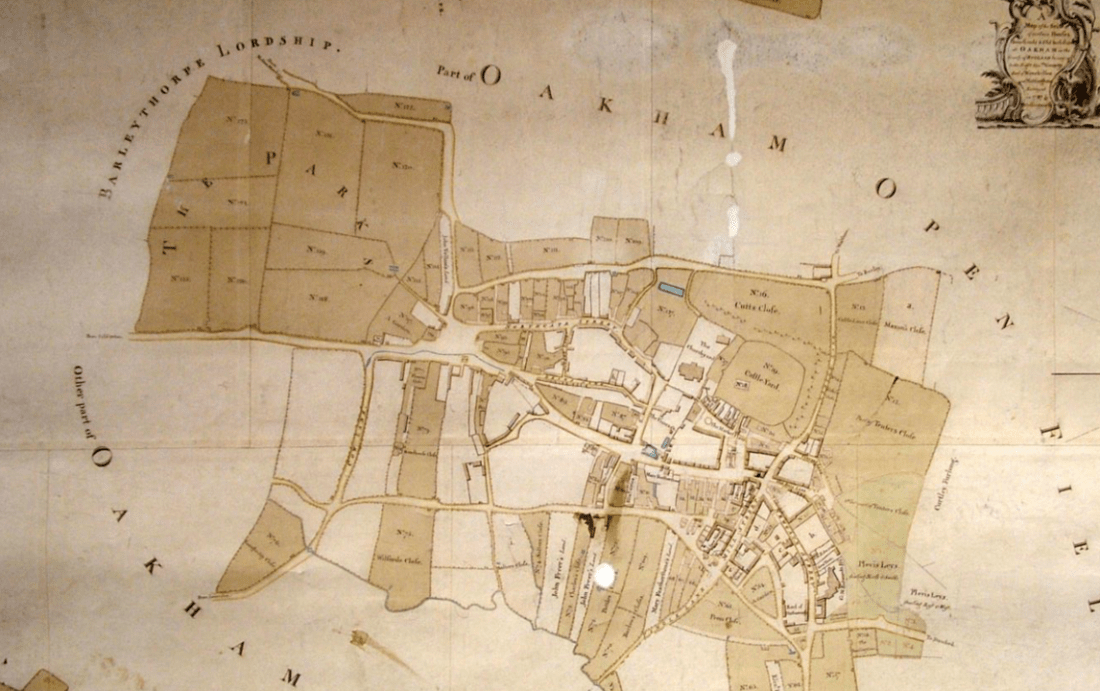
In the monograph “Oakham Lordshold in 1787”, Clough (2016) considers the map of the town of Oakham in Rutland produced for Lord Winchilsea in that year. This is the earliest map to show significant detail of the urban topography of the town, and from it Clough was able to infer some aspects of its late Anglo-Saxon / early Norman topography, in particular the existence of two enclosures encompassing the castle and the church, and the castle and a large portion of the town. In this post. I take his considerations somewhat further and, by considering the likely Anglo-Saxon road network around Oakham, infer some further features of the Anglo-Saxon urban topography.
Oakham connections
Cox (1994) in his extensive survey of Rutland place names, identifies a number of settlements in the Oakham area that were likely to have been in existence in the sixth and seventh centuries i.e. early on the Anglo Saxon era. These are as follows.
Place names ending in -ham, meaning village or estate. These include Oakham itself; Langham and Wymondham to the north west; Greetham and Grantham to the north east, Empingham to the east and Uppingham to the south.
Place names ending in -dun meaning a large hill, of which the only one in the vicinity of Oakham is Hambleton.
Place names associated with the Anglian tribe of the Hwicce of which Whissendine to the north of Oakham is the only one locally.
The villages of Brooke, which has an early attestation, and Braunston, which incorporates an early form of Anglo-Saxon name and has possible Roman antecedents.
The -well names meaning spring, and in particular Ashwell, although this might be slightly later than the others.
The major settlements in the wider region either with proven continuity since the Roman period or are of an early form- Leicester, Nottingham, Lincoln and Stamford.
In what follows we presume that in the Anglo-Saxon and Norman periods, Oakham had road / pathway connections to these early settlements that are, broadly, the predecessors of those we see today at least out of the settlements themselves. Country roads are very conservative topographical features and change little over the centuries. Within, and on the entry to settlements, they would however have been more prone to change, because of building and commercial developments. In these terms we will consider seven such roads that converge on Oakham and in particular we attempt to trace the “natural” course of these roads into and through the town, again assuming that these are the courses that would have been followed in the Anglo-Saxon period, rather than the courses that have developed over the centuries.
But first a broader point is worth making. Oakham was in the ninth and tenth centuries was in many ways at the centre of the Danelaw, with roads passing through it that connected Leicester in the west to Stamford and Lincoln in the east, and Northampton in the south with Derby and Nottingham in the north. As such, it is likely to have been of some strategic importance, particularly during the period when King Edward and Lady Aethelflead finally defeated the Danish armies in the area between 910 and 920.
The Anglo-Saxon roads
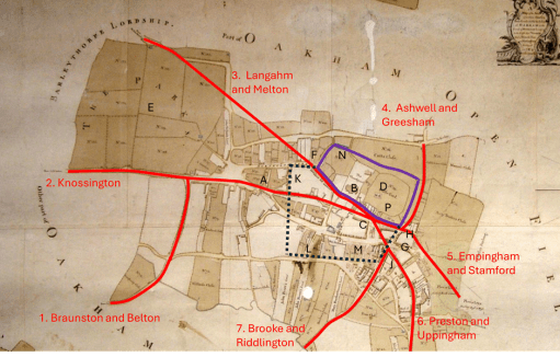
The roads that we are considering are shown in Figure 1 on a copy of the 1787 map as given in Clough (2016). These are as follows.
Figure 1. The proposed early road layout
Road 1 from Belton and Braunston (and beyond that Leicester) that runs up what is now Braunston Road and West Road (formerly known as Cow Lane) and joins Road 2 to the west of Oakham.
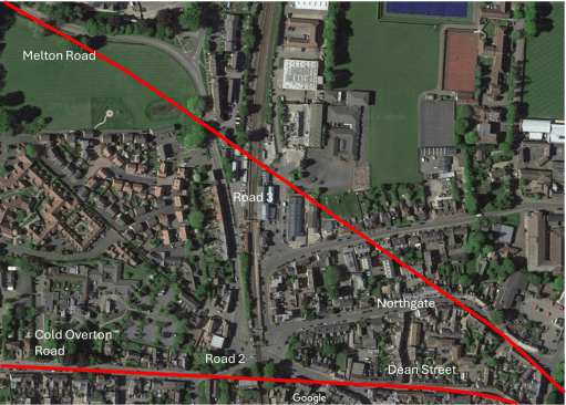
Road 2, the current Cold Overton Rd from Knossington, runs in a west to east direction, across what would become many centuries later the railway crossing and into Oakham. If the line of the road is continued, it runs along Dean Street (A) towards the church (B), and not along High Street. This straight alignment is very clear from the satellite view of figure 2. I will argue below that High Street was a relatively late development and was laid out in the Norman period. I have then shown the road running to a point in the current market place (C) in front of the castle (D) although this last stretch is conjectural.
Road 3 is the road from Melton Mowbray (and Derby and Nottingham beyond) through Wymondham and Langham. The modern approach to Oakham is via a sharp 90 degree turn along the railway down towards the level crossing. It will be seen below that this route was actually in place in the 16th century at the latest, so it is not a modern development. However, here we take the natural line of the road to continue from the north of the area marked as the Parks (E) towards the sharp kink in the modern Northgate (F) and then following Northgate and Church Alley to a junction with Road 2 in the Market Place. Again, this natural course is very obvious on the satellite view of Figure 2. This seems a much more natural route into the centre of the town.
Road 4 is from Ashwell and Greesham (and beyond that Grantham) that is taken to follow the existing course of Burley Rd. east of the castle to a junction with Road 5.
The course of Road 5 from Stamford and Empingham has changed significantly over the centuries, as it was moved to loop around Catmose Hall. Clough conjectures that it used to entire town through either or both of Bull Lane (G) or Tanners Lane (H) to the north of Bull St. We choose the latter course here as it allows this road to meet those from the west in the Market Place.
Road 6 from Uppingham and Preston follows its modern course to the end of Mill St. (J) and then cuts across to meet the other roads in the Market Place,
Road 7 from Brooke and Riddlington follows the current course of Mill St. to a junction with Road 6 (J).
Figure 2. Satellite views of the western and northern approaches
The Saxon / early Norman enclosures.
Figure 1 also shows two enclosures. The black dotted lines is a (very) conjectural boundary of the Anglo-Saxon settlement, based on the discovery of boundary ditches at K, L and M summarised by Clough. The purple solid line is the enclosure surrounding the castle and the church identified by Clough, largely on the basis of the flooded ditch at N (that has also been identified in archaeological investigations). Taken together these two enclosures would seem to represent the extent of the Anglo—Saxon and early Norman settlement. The strategic and defensive position of the castle (and in particular the Motte in the south east corner P) adjacent to the meeting point of the roads through the town is very clear. The most striking point about the proposed reconstruction is the absence of the High Street – its anomalous orientation with regard to the other roads suggests it postdated the original road layout. South Street was however likely to be in existence early as it marks the southern boundary of the enclosure. Note its original course ran straight from the west to the east, and did not diverge to the south east at its eastern end.
Changes in the Norman period
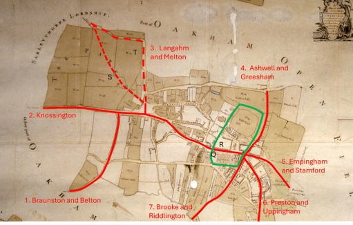
Figure 3. The post-conquest road layout
Figure 3 shows the road system and enclosures in the later Norman period. Clough identified the enclosure outlined in green that contains the castle and the portion of the town to the south. He speculates that the pattern of enclosures was changed when the manor was relinquished by (probably) William II and divided between Lordshold and Deanshold (the Dean referring to being that of Westminster Abbey), with the results that the church and the castle holdings were separated. This enclosure was again identified on the basis of a flooded ditch at Q. Clearly the function of this enclosure is very different and seems to be about controlling the movement of people and goods through the town (presumably for taxation purposes). It is like that this is the period when the current High Street came into existence. The Speed map of 1611 (Figure 4) shows “Bargate” at R, (built into the current Flores House) where presumably people and goods were assessed . The road system has also been changed to ensure all traffic flows along High Street. In the west, Road 3 was rerouted, probably in the first instance to follow the current line of Park Lane (S) down to Road 2. At some point the area named as the Parks was enclosed (both routes are shown on the 1611 map), and the route would again have been changed to run around this area, resulting in the modern road configuration (T). The current traffic chaos around the level crossing on the Cold Overton Road thus has its genesis many centuries ago! The combined roads 2 and 3 were then rerouted along the new High Street, rather than down Dean Street. To the east, it is likely that the Stamford Road was rerouted to come into town via what is now Bull Lane.
Figure 4. The Speed map of 1611
Loose ends
In this final section we note a number of what might be called loose ends in the above argument – the lack of destinations for one of the identified roads; the lack of direct roads from a significant place in the locality and the nature of the town “gates”.
A road to nowhere
Road 2 approaches Oakham on a straight route from the west, and within the town becomes Dean Street. But where was it coming from? There are no settlements out in that direction that can be confidently given an early date. Two thoughts come to mind – either that it was part of a somewhat roundabout route to Leicester, or that it was the route to what can be surmised to be early fortifications of the Rutland border to the west (where a number of names indicate beacons). There are no doubt other possibilities.
The route to Hambleton
There are clear indications in Domesday that the major settlement in the area at the time was Hambleton, and it was suggested above that this settlement was of an early date. As far as can be ascertained from the fairly recent maps that are available, the route there was a 90 degree junction of the Stamford Road (see the 1900 Ordnance Survey map of Figure 5). However the map shows a pedestrian way to the west of the junction that cuts of a corner and is a much more natural way to Hambleton. It seems possible that the Stamford Road bifurcated at that point with branches to Empingham and Stamford to the north and Hambleton and Ketton to the south, but that this junction was supressed during the enclosures. So Road 5 might better be referred to as the road to Hambleton, Empingham and Stamford
Figure 5. The road to Hambleton (from 1900 Ordnance Survey map
The gates
“Gates” is an ambiguous word. It can either refer to a physical gate to the town, or be a derivation from the Norse -gata simply meaning road. Bearing this in mind, Clough identifies two gates – an East gate at the entry of the Stamford Road into the enclosure around the present Bull Lane, and a West gate – the Bar-gate mentioned above. The road system was clearly arranged to direct all traffic through these, and resulted in quite a small central enclosure.
Now, whilst no south gate has ever been identified, from the earliest maps, there is a Gibbet Gate shown on the Speed Map on Stamford Road (Figure 4). This is someway outside the enclosed areas, and is this case the word gate probably simply defines a road rather than anything else. albeit one leading to a somewhat grisly destination.
The name Northgate, however, appears on a number of maps. On the Speed map this is positioned somewhere near the railway crossing, and on later maps, the current Northgate is known by either that name or by Northgate Street. Again, this could either refer to an actual gate to the town, or simply a way to denote a road. But if there was an actual North Gate, where was it? In my view, the most likely position is at the current sharp junction of the modern Northgate – F in figure 1, on the original Melton Road and at the possible confluence of the Saxon town and Castle / Church enclosures. A modern photograph is shown in Figure 6 below – taken from the east showing the possible location of the north gate (the thatched cottages) and the line of the road from there to the castle.
Figure 6. The possible location of the north gate
References
Clough T. H. McK. (2016) ” Oakham Lordshold in 1787 – A map and survey of Lord Winchilsea’s Oakham estate” Rutland Local History & Record Society, Occasional Publication No 12
Cox B (1994) “The place-names of Rutland” English Place Name Society
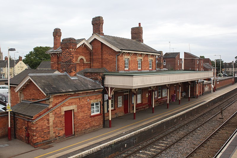
In this post we will consider how bus and train transport in Oakham has changed from the 1960s to the present day, for both good and bad. To do so, we will use a variety of historical resources, primarily old bus and rail timetables. We will look at four time slices – at the state of the railways in the early 1960s i.e. before the Beeching cuts; at the bus services and train service provided in the late 1960s, after Beeching but before bus deregulation; in the late 1990s after rail privatization and bus deregulation; and the current situation. The time slices chosen have in effect been determined by what information is available. However, between them they give a clear picture of how bus and train services in Oakham have developed (or perhaps degraded) over the last 50 to 60 years.
Sources and limitations
For the early 1960 rail services we use the following sources:
London Midland Region timetable for 1963 and 1965 (personal collection);
These are quite comprehensive and give a full coverage of the rail services at that time, which is of course before the Beeching Report and associated closures. The sources for the late 1960s are both taken from Timetable World:
London Midland Region timetable for 1969;
Bus timetables for the late 1960s.
Whilst the rail timetables can again be expected to be comprehensive, the bus timetables are probably less so. Finding services through Oakham requires a search of the index for bus companies operating in the area. It is possible that I have missed some potential sources of information, although I believe I have captured most of the main services. What I have almost certainly missed are any very local services operated by small operators in the Oakham district, which simply do not appear on the Timetable World web site. The bus timetables are from the years 19868 and 1969 with one exception from 1973 (for a Saturday only service). For the late 1990s we obtain information from the following sources:
Railtrack Great Britain timetable for 1999 (from Timetable World);
Great Britain Bus Timetable 1999 (personal collection).
The Great British Bus Timetable is a compilation of services from across Great Britain. It admits that it excludes local operators and services of a purely local nature, so again the bus information might not be fully comprehensive here. For the current situation we used information for bus and train times that is available on the web as follows:
In the analysis that follows, we will identify bus and train operators by a two letter code.
BL – Blands of Cottesmore – a local bus company based in a village to the east of Oakham.
BA – Bartons or Barton Tobin Hood – a large regional bus company based around Nottingham, but with a garage in Stamford.
BR – British Rail – the National pre-privatisation rail operator.
CB – CentreBus – an East Midlands regional operator.
CC – Cross Country Trains – the current franchise operator of trains through Oakham, with a wide nationwide network.
CT – Central Trains – a previous operator of trains through Oakham, based in Birmingham with a wide regional network across the Midlands.
EM – East Midlands Railway – the mainline train operator serving the East Midlands cities, that runs occasional services through Oakham (and is, bizarrely, the firm responsible for running the station).
KI – Kinchbus – a small Loughborough based bus company
LR – Lincolnshire Road Car – a large regional company in the 1960s, primarily based, as might be expected, in Lincolnshire.
MR – Midland Red Leicester – the regional operator of the very large Midland Red network that operated buses across the wider Midlands area.
RC – Rutland County Council – which currently operates a small number of services for which no franchise partner could be found.
UC – United Counties Omnibus Company – a large regional company primarily based in the Northampton area.
Analysis
In what follows we consider the public transport services through time in four categories:
Local interurban services to Stamford, Melton Mowbray and Uppingham;
Regional services to Peterborough, Leicester, Nottingham, Grantham and Corby;
Long distance services to Birmingham, Cambridge and London;
Miscellaneous services for which information is incomplete – very local services, long distance coaches etc.
For the first three categories we present the data in tabular form in a consistent format, and then discuss how these have evolved over time. Discussion of the latter category is inevitably rather more diffuse due to the lack of much historical information.
Local interurban services
Tables 1 to 3 show, in standard form, the bus and train services between Oakham and Stamford, Melton Mowbray and Uppingham. Journey times and number of journeys / day are shown. Clearly there are both train and bus options to Stamford and Melton Mowbray, but only bus options to Uppingham. The bus journeys in 1969 and 1999 were provided by major bus operators for which Oakham was at the edge of their operating area – United Counties in Northampton, Lincolnshire road Car, Bartons in Nottingham, Kinchbus in Loughborough. Currently they are provided by more local operators – primarily Blands, but with Rutland County Council running the current Oakham to Stamford service. The bus journey times and service frequencies have remained similar over the period (although note that the former can vary significantly depending on what villages are served on the way between urban centres. The loss of Sunday services is obvious from the data in the tables. What is not so obvious is the fact that evening services on all the bus routes have been significantly cut over the study period.
By contracts the train services have seen major improvement. The Leicester to Peterborough shuttles stopped at all the village stations before Beeching and the journey times between Oakham and Melton Mowbray and Stamford were of the order of 20 minutes. By 1969 these stations had closed and the journey times significantly reduced. This reduction has continued up to the present with faster stock being introduced on the line and, most significantly, the number of journeys has increased by a factor of two with the introduction of hourly through Birmingham to Cambridge / Stansted Airport services. These improvements have however resulted in a significant loss of connectivity to the villages where stations were closed in the 1960s.
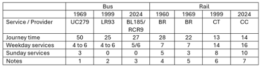
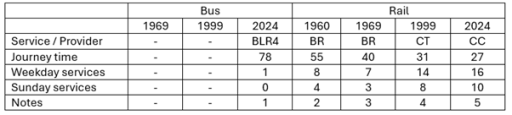
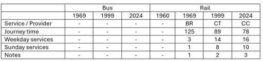
Table 1. Oakham to Stamford
Uppingham to Stamford via Ridlington, Wing, Oakham (Railway Station Crossing), Exton, Whitwell, Empingham and Great Casterton. UC also operated service 280 with one return journey on Fridays only from Oakham to Stamford vis Edith Weston.
Oakham to Stamford via Whitwell, Empingham and Great Casterton.
Oakham to Stamford via Whitwell, Empingham and Great Casterton. BL185 has one service from Monday to Friday and four on Saturday. RCR9 has five services Monday to Friday.
Leicester to Peterborough East via Syston, Frisby, Melton Mowbray, Saxby, Ashwell, Oakham, Manton for Uppingham, Luffenham, Ketton and Collyweston, Stamford, Helpston and (for some journeys) Peterborough North.
Leicester to Peterborough via Melton Mowbray, Oakham and Stamford
Birmingham to Cambridge / Stansted Airport via Leicester, Melton Mowbray, Stamford and Peterborough.
Birmingham to Cambridge / Stansted Airport via Leicester, Melton Mowbray, Stamford and Peterborough. Also, two early morning / late evening EM services from Nottingham to Norwich calling at Loughborough, Melton Mowbray, Stamford and Peterborough (not included in table).
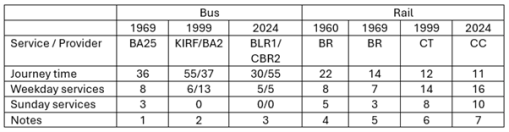
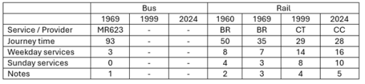
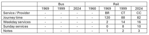
Table 2. Oakham to Melton Mowbray
Melton Mowbray to Oakham (Station Approach) via Whissendine, Ashwell and Langham. Also, four journeys / day Oakham to Langham only.
KIRF (Rutland Flyer) Corby to Melton Mowbray via Uppingham, Oakham and Cottesmore; BA2 Uppingham to Nottingham via Oakham, Langham, Whissendine and Melton Mowbray.
BLR1 Corby to Melton Mowbray via Uppingham, Oakham, Langham and Whissendine; CBR2 is Oakham to Melton Mowbray via Exton, Cottesmore and Whymondham. Also, one BLR4 service per day Melton Mowbray to Peterborough via Oakham and Uppingham (not shown in table).
Leicester to Peterborough East via Syston, Frisby, Melton Mowbray, Saxby, Ashwell, Oakham, Manton for Uppingham, Luffenham, Ketton and Collyweston, Stamford, Helpston and (for some journeys) Peterborough North.
Leicester to Peterborough via Melton Mowbray, Oakham and Stamford.
Birmingham to Cambridge / Stansted Airport via Leicester, Melton Mowbray, Stamford and Peterborough.
Birmingham to Cambridge / Stansted Airport via Leicester, Melton Mowbray, Stamford and Peterborough. Also, two early morning / late evening EMT services from Nottingham to Norwich calling at Loughborough, Melton Mowbray, Stamford and Peterborough (not included in table).
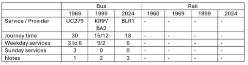
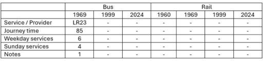
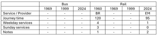
Table 3. Oakham to Uppingham
Uppingham to Stamford via Ridlington, Wing, Oakham (Railway Station Crossing), Exton, Whitwell, Empingham and Great Casterton.
KIRF (Rutland Flyer) Corby to Melton Mowbray via Uppingham, Oakham and Cottesmore; BA2 Uppingham to Nottingham via Oakham, Langham, Whissendine and Melton Mowbray.
Corby to Melton Mowbray via Uppingham, Oakham, Langham and Whissendine
Regional interurban services
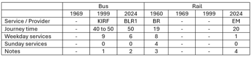
In this section we consider the evolution of services from Oakham to the major surrounding conurbations of Peterborough, Leicester, Nottingham, Grantham and Corby (Tables 4 to 8). With regard to Peterborough and Leicester, the same remarks can be made as in the last section in terms of the rail services, with steadily decreasing journey times and a major improvement in service frequency. For both towns there have only ever been occasional and sporadic bus links, addressing specific leisure, employment or educational needs, with long journey times. Direct services to Grantham were an early casualty of service rationalization and were not provided after the early 1970s.
In the early 1960s train services were provided from Nottingham to Melton Mowbray, Oakham, Corby, Kettering and beyond. Services on this line were a major casualty of the Beeching closures and there are now only very limited rail services to both Nottingham and Corby. Whilst there was quite a good bus service from Oakham to Nottingham in 1999, operated by Barton, this did not last and there are now no direct bus services to that city. There are, however, regular services to Corby that run through Oakham to Melton Mowbray. In 1999 these were provided by Kinchbus and marketed as the Rutland Flyer. Now the service is operated by Blands. Journey times are of the order of 40 to 50 minutes.
Table 4. Oakham to Peterborough
Melton Mowbray to Peterborough via Langham, Oakham, Uppingham and South Luffernaham.
Leicester to Peterborough East via Syston, Frisby, Melton Mowbray, Saxby, Ashwell, Oakham, Manton for Uppingham, Luffenham, Ketton and Collyweston, Stamford, Helpston and (for some journeys) Peterborough North
Leicester to Peterborough via Melton Mowbray, Oakham and Stamford
Birmingham to Cambridge / Stansted Airport via Leicester, Melton Mowbray, Stamford and Peterborough.
Birmingham to Cambridge / Stansted Airport via Leicester, Melton Mowbray, Stamford and Peterborough. Also, two early morning / late evening trains from Nottingham to Norwich calling at Loughborough, Melton Mowbray, Stamford and Peterborough (not included in table).
Table 5. Oakham to Leicester
Saturdays only. Oakham (Station Road) to Leicester via Braunston, Knossington, Cold Overton and Melton Mowbray.
Leicester to Peterborough East via Syston, Frisby, Melton Mowbray, Saxby, Ashwell, Oakham, Manton for Uppingham, Luffenham, Ketton and Collyweston, Stamford, Helpston and (for some journeys) Peterborough North.
Leicester to Peterborough via Melton Mowbray, Oakham and Stamford
Birmingham to Cambridge / Stansted Airport via Leicester, Melton Mowbray, Stamford and Peterborough.
Birmingham to Cambridge / Stansted Airport via Leicester, Melton Mowbray, Stamford and Peterborough. Also two early morning / late evening trains from Nottingham to Norwich calling at Loughborough, Melton Mowbray, Stamford and Peterborough (not included in table).
Table 6. Oakham to Grantham
Oakham (Railway Station) to Grantham, calling at Cottesmore, Greetham, Market Overton and Thistleton. Also 3 journeys from Oakham to Cottesmore only.
Table 7. Oakham to Nottingham
Nottingham to Uppingham via Melton Mowbray, Whissendine, Langham and Oakham.
Nottingham to Kettering, via Old Dalby, Melton Mowbray, Oakham, Manton for Uppingham, Gretton, Corby and Kettering, Two or three of these were from Nottingham (and beyond) to London St Pancras.
Nottingham to Norwich calling at (Leicester), Loughborough, Melton Mowbray, Oakham, Stamford and Peterborough (early morning and late evening only)
Table 8. Oakham to Corby
Corby to Melton Mowbray via Uppingham, Oakham and Cottesmore.
Corby to Melton Mowbray via Uppingham and Oakham
Nottingham to Kettering, via Old Dalby, Melton Mowbray, Oakham, Manton for Uppingham, Gretton, Corby and Kettering. Two or three of these were from Nottingham (and beyond) to London St Pancras.
Melton Mowbray to London St Pancras calling at Oakham and Kettering.
Long distance services
The three long-distance services we consider are Oakham to Birmingham, Cambridge and London (Tables 9 to 11). All of these are rail based. The first two reflect the changes described above to the Leicester to Peterborough services with a significantly increased number of services and steadily reducing journey times. The London situation is very different. When services ran from Nottingham to London via Oakham in the early 1960s, there were four trains to and from London each day. After Beeching these were withdrawn completely and it is only in recent years that one journey, from Melton Mowbray to London has been reinstated. Thus whilst there has been considerable improvement in east / west connectivity, north / south connectivity has been reduced to a nominal level.
Table 9. Oakham to Birmingham
Birmingham to Cambridge / Norwich via Leicester, Melton Mowbray, Stamford and Peterborough.
Birmingham to Cambridge / Stansted Airport via Leicester, Melton Mowbray, Stamford and Peterborough.
Birmingham to Cambridge / Stansted Airport via Leicester, Melton Mowbray, Stamford and Peterborough
Table 10. Oakham to Cambridge
Birmingham to Cambridge via Leicester, Melton Mowbray, Stamford and Peterborough.
Birmingham to Cambridge / Stansted Airport via Leicester, Melton Mowbray, Stamford and Peterborough. Birmingham to Cambridge / Stansted Airport via Leicester, Melton Mowbray, Stamford and Peterborough
Table 11. Oakham to London
Nottingham to Kettering, via Old Dalby, Melton Mowbray, Oakham, Manton for Uppingham, Gretton, Corby and Kettering. Two or three of these were from Nottingham (and beyond) to London St Pancras.
Melton Mowbray to London St Pancras via Oakham and Kettering
Other services
When looking at the information available from the sources listed above, it is clear that there are two broad categories of bus service that are not fully represented – very local services in and around Oakham and the nearby villages; and long-distance coach services. With regard to the former, it is known that local companies such as Blands provided specific services to places of work and education and indeed that still continues in the latest timetable. These are usually one or two journeys a day with no wider public transport relevance. Als Rutland County Council operate a minibus Rutland Hopper service around the town to out-of-town stores and local villages.
It is also clear that some long distance coaches operated through Oakham, but these are not easy to find, usually occurring in specific operators timetables. For example, in 1968 Barton operated a long-distance coach service between Corby and Glasgow (presumably for steel worker s to visit families), with daytime trips on Sunday, Monday and Wednesday, and overnight trips on Friday and Saturday, that picked up and dropped off at the Crown Hotel. Similarly in 1969 Trent Motor Traction, based in Derbyshire and Nottinghamshire ran weekend services from Derby and Nottingham to Southend on Sea, Cambridge and Clacton that ran through Oakham, picking up and setting down at the Market Place. There were no doubt other similar occasional services.
Conclusions
So what can one conclude from the data presented above? Firstly with regard to rail services, it is clear that there have been major improvements in connectivity to the east and the west, with reducing journey times and increased frequencies. That being said, current reliability and punctuality is poor and requires improvement. Services to the north and south have however seen major degradation and are now only represented by one journey a day to London. With regard to bus services, in some sense these have seen little change, with journey times and frequencies on most routes remaining broadly constant, at least on weekdays. That being said, there have been some losses – to Grantham and Nottingham in particular, Sunday services are non-existent and evening services have been severely cut back, Perhaps more importantly the service times and frequencies that were acceptable in the 1960s now simply represent a very basic service that is not attractive to most car-owning travelers.


.jpg)