Introduction
In this post we will consider how bus and train transport in Oakham has changed from the 1960s to the present day, for both good and bad. To do so, we will use a variety of historical resources, primarily old bus and rail timetables. We will look at four time slices – at the state of the railways in the early 1960s i.e. before the Beeching cuts; at the bus services and train service provided in the late 1960s, after Beeching but before bus deregulation; in the late 1990s after rail privatization and bus deregulation; and the current situation. The time slices chosen have in effect been determined by what information is available. However, between them they give a clear picture of how bus and train services in Oakham have developed (or perhaps degraded) over the last 50 to 60 years.
Sources and limitations
For the early 1960 rail services we use the following sources:
- London Midland Region timetable for 1963 and 1965 (personal collection);
- Bradshaw’s Guide 1961 (from Timetable World).
These are quite comprehensive and give a full coverage of the rail services at that time, which is of course before the Beeching Report and associated closures. The sources for the late 1960s are both taken from Timetable World:
- London Midland Region timetable for 1969;
- Bus timetables for the late 1960s.
Whilst the rail timetables can again be expected to be comprehensive, the bus timetables are probably less so. Finding services through Oakham requires a search of the index for bus companies operating in the area. It is possible that I have missed some potential sources of information, although I believe I have captured most of the main services. What I have almost certainly missed are any very local services operated by small operators in the Oakham district, which simply do not appear on the Timetable World web site. The bus timetables are from the years 19868 and 1969 with one exception from 1973 (for a Saturday only service). For the late 1990s we obtain information from the following sources:
- Railtrack Great Britain timetable for 1999 (from Timetable World);
- Great Britain Bus Timetable 1999 (personal collection).
The Great British Bus Timetable is a compilation of services from across Great Britain. It admits that it excludes local operators and services of a purely local nature, so again the bus information might not be fully comprehensive here. For the current situation we used information for bus and train times that is available on the web as follows:
- Rutland County Council Bus Timetable 2024;
- Cross Country Train timetable 2024;
- East Midlands Railway Timetable 2024.
Operators
In the analysis that follows, we will identify bus and train operators by a two letter code.
- BL – Blands of Cottesmore – a local bus company based in a village to the east of Oakham.
- BA – Bartons or Barton Tobin Hood – a large regional bus company based around Nottingham, but with a garage in Stamford.
- BR – British Rail – the National pre-privatisation rail operator.
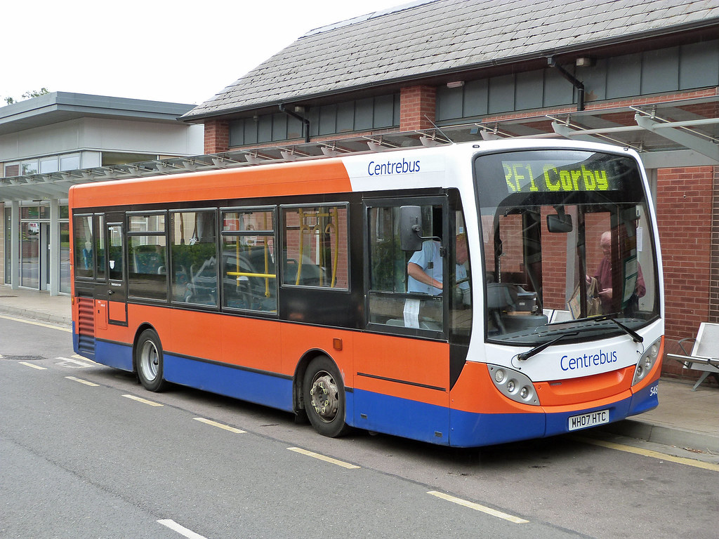
- CB – CentreBus – an East Midlands regional operator.
- CC – Cross Country Trains – the current franchise operator of trains through Oakham, with a wide nationwide network.
- CT – Central Trains – a previous operator of trains through Oakham, based in Birmingham with a wide regional network across the Midlands.
- EM – East Midlands Railway – the mainline train operator serving the East Midlands cities, that runs occasional services through Oakham (and is, bizarrely, the firm responsible for running the station).
- KI – Kinchbus – a small Loughborough based bus company
- LR – Lincolnshire Road Car – a large regional company in the 1960s, primarily based, as might be expected, in Lincolnshire.
- MR – Midland Red Leicester – the regional operator of the very large Midland Red network that operated buses across the wider Midlands area.
- RC – Rutland County Council – which currently operates a small number of services for which no franchise partner could be found.
- UC – United Counties Omnibus Company – a large regional company primarily based in the Northampton area.
Analysis
In what follows we consider the public transport services through time in four categories:
- Local interurban services to Stamford, Melton Mowbray and Uppingham;
- Regional services to Peterborough, Leicester, Nottingham, Grantham and Corby;
- Long distance services to Birmingham, Cambridge and London;
- Miscellaneous services for which information is incomplete – very local services, long distance coaches etc.
For the first three categories we present the data in tabular form in a consistent format, and then discuss how these have evolved over time. Discussion of the latter category is inevitably rather more diffuse due to the lack of much historical information.
Local interurban services
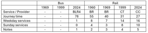
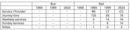
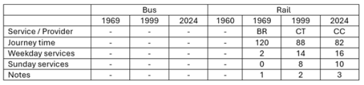
Tables 1 to 3 show, in standard form, the bus and train services between Oakham and Stamford, Melton Mowbray and Uppingham. Journey times and number of journeys / day are shown. Clearly there are both train and bus options to Stamford and Melton Mowbray, but only bus options to Uppingham. The bus journeys in 1969 and 1999 were provided by major bus operators for which Oakham was at the edge of their operating area – United Counties in Northampton, Lincolnshire road Car, Bartons in Nottingham, Kinchbus in Loughborough. Currently they are provided by more local operators – primarily Blands, but with Rutland County Council running the current Oakham to Stamford service. The bus journey times and service frequencies have remained similar over the period (although note that the former can vary significantly depending on what villages are served on the way between urban centres. The loss of Sunday services is obvious from the data in the tables. What is not so obvious is the fact that evening services on all the bus routes have been significantly cut over the study period.
By contracts the train services have seen major improvement. The Leicester to Peterborough shuttles stopped at all the village stations before Beeching and the journey times between Oakham and Melton Mowbray and Stamford were of the order of 20 minutes. By 1969 these stations had closed and the journey times significantly reduced. This reduction has continued up to the present with faster stock being introduced on the line and, most significantly, the number of journeys has increased by a factor of two with the introduction of hourly through Birmingham to Cambridge / Stansted Airport services. These improvements have however resulted in a significant loss of connectivity to the villages where stations were closed in the 1960s.
Table 1. Oakham to Stamford
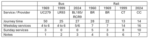
- Uppingham to Stamford via Ridlington, Wing, Oakham (Railway Station Crossing), Exton, Whitwell, Empingham and Great Casterton. UC also operated service 280 with one return journey on Fridays only from Oakham to Stamford vis Edith Weston.
- Oakham to Stamford via Whitwell, Empingham and Great Casterton.
- Oakham to Stamford via Whitwell, Empingham and Great Casterton. BL185 has one service from Monday to Friday and four on Saturday. RCR9 has five services Monday to Friday.
- Leicester to Peterborough East via Syston, Frisby, Melton Mowbray, Saxby, Ashwell, Oakham, Manton for Uppingham, Luffenham, Ketton and Collyweston, Stamford, Helpston and (for some journeys) Peterborough North.
- Leicester to Peterborough via Melton Mowbray, Oakham and Stamford
- Birmingham to Cambridge / Stansted Airport via Leicester, Melton Mowbray, Stamford and Peterborough.
- Birmingham to Cambridge / Stansted Airport via Leicester, Melton Mowbray, Stamford and Peterborough. Also, two early morning / late evening EM services from Nottingham to Norwich calling at Loughborough, Melton Mowbray, Stamford and Peterborough (not included in table).
Table 2. Oakham to Melton Mowbray
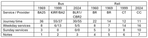
- Melton Mowbray to Oakham (Station Approach) via Whissendine, Ashwell and Langham. Also, four journeys / day Oakham to Langham only.
- KIRF (Rutland Flyer) Corby to Melton Mowbray via Uppingham, Oakham and Cottesmore; BA2 Uppingham to Nottingham via Oakham, Langham, Whissendine and Melton Mowbray.
- BLR1 Corby to Melton Mowbray via Uppingham, Oakham, Langham and Whissendine; CBR2 is Oakham to Melton Mowbray via Exton, Cottesmore and Whymondham. Also, one BLR4 service per day Melton Mowbray to Peterborough via Oakham and Uppingham (not shown in table).
- Leicester to Peterborough East via Syston, Frisby, Melton Mowbray, Saxby, Ashwell, Oakham, Manton for Uppingham, Luffenham, Ketton and Collyweston, Stamford, Helpston and (for some journeys) Peterborough North.
- Leicester to Peterborough via Melton Mowbray, Oakham and Stamford.
- Birmingham to Cambridge / Stansted Airport via Leicester, Melton Mowbray, Stamford and Peterborough.
- Birmingham to Cambridge / Stansted Airport via Leicester, Melton Mowbray, Stamford and Peterborough. Also, two early morning / late evening EMT services from Nottingham to Norwich calling at Loughborough, Melton Mowbray, Stamford and Peterborough (not included in table).
Table 3. Oakham to Uppingham
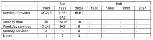
- Uppingham to Stamford via Ridlington, Wing, Oakham (Railway Station Crossing), Exton, Whitwell, Empingham and Great Casterton.
- KIRF (Rutland Flyer) Corby to Melton Mowbray via Uppingham, Oakham and Cottesmore; BA2 Uppingham to Nottingham via Oakham, Langham, Whissendine and Melton Mowbray.
- Corby to Melton Mowbray via Uppingham, Oakham, Langham and Whissendine
Regional interurban services
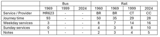
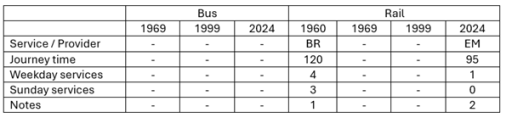
In this section we consider the evolution of services from Oakham to the major surrounding conurbations of Peterborough, Leicester, Nottingham, Grantham and Corby (Tables 4 to 8). With regard to Peterborough and Leicester, the same remarks can be made as in the last section in terms of the rail services, with steadily decreasing journey times and a major improvement in service frequency. For both towns there have only ever been occasional and sporadic bus links, addressing specific leisure, employment or educational needs, with long journey times. Direct services to Grantham were an early casualty of service rationalization and were not provided after the early 1970s.
In the early 1960s train services were provided from Nottingham to Melton Mowbray, Oakham, Corby, Kettering and beyond. Services on this line were a major casualty of the Beeching closures and there are now only very limited rail services to both Nottingham and Corby. Whilst there was quite a good bus service from Oakham to Nottingham in 1999, operated by Barton, this did not last and there are now no direct bus services to that city. There are, however, regular services to Corby that run through Oakham to Melton Mowbray. In 1999 these were provided by Kinchbus and marketed as the Rutland Flyer. Now the service is operated by Blands. Journey times are of the order of 40 to 50 minutes.
Table 4. Oakham to Peterborough
- Melton Mowbray to Peterborough via Langham, Oakham, Uppingham and South Luffernaham.
- Leicester to Peterborough East via Syston, Frisby, Melton Mowbray, Saxby, Ashwell, Oakham, Manton for Uppingham, Luffenham, Ketton and Collyweston, Stamford, Helpston and (for some journeys) Peterborough North
- Leicester to Peterborough via Melton Mowbray, Oakham and Stamford
- Birmingham to Cambridge / Stansted Airport via Leicester, Melton Mowbray, Stamford and Peterborough.
- Birmingham to Cambridge / Stansted Airport via Leicester, Melton Mowbray, Stamford and Peterborough. Also, two early morning / late evening trains from Nottingham to Norwich calling at Loughborough, Melton Mowbray, Stamford and Peterborough (not included in table).
Table 5. Oakham to Leicester
- Saturdays only. Oakham (Station Road) to Leicester via Braunston, Knossington, Cold Overton and Melton Mowbray.
- Leicester to Peterborough East via Syston, Frisby, Melton Mowbray, Saxby, Ashwell, Oakham, Manton for Uppingham, Luffenham, Ketton and Collyweston, Stamford, Helpston and (for some journeys) Peterborough North.
- Leicester to Peterborough via Melton Mowbray, Oakham and Stamford
- Birmingham to Cambridge / Stansted Airport via Leicester, Melton Mowbray, Stamford and Peterborough.
- Birmingham to Cambridge / Stansted Airport via Leicester, Melton Mowbray, Stamford and Peterborough. Also two early morning / late evening trains from Nottingham to Norwich calling at Loughborough, Melton Mowbray, Stamford and Peterborough (not included in table).
Table 6. Oakham to Grantham
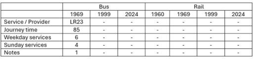
- Oakham (Railway Station) to Grantham, calling at Cottesmore, Greetham, Market Overton and Thistleton. Also 3 journeys from Oakham to Cottesmore only.
Table 7. Oakham to Nottingham

- Nottingham to Uppingham via Melton Mowbray, Whissendine, Langham and Oakham.
- Nottingham to Kettering, via Old Dalby, Melton Mowbray, Oakham, Manton for Uppingham, Gretton, Corby and Kettering, Two or three of these were from Nottingham (and beyond) to London St Pancras.
- Nottingham to Norwich calling at (Leicester), Loughborough, Melton Mowbray, Oakham, Stamford and Peterborough (early morning and late evening only)
Table 8. Oakham to Corby
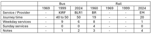
- Corby to Melton Mowbray via Uppingham, Oakham and Cottesmore.
- Corby to Melton Mowbray via Uppingham and Oakham
- Nottingham to Kettering, via Old Dalby, Melton Mowbray, Oakham, Manton for Uppingham, Gretton, Corby and Kettering. Two or three of these were from Nottingham (and beyond) to London St Pancras.
- Melton Mowbray to London St Pancras calling at Oakham and Kettering.
Long distance services
The three long-distance services we consider are Oakham to Birmingham, Cambridge and London (Tables 9 to 11). All of these are rail based. The first two reflect the changes described above to the Leicester to Peterborough services with a significantly increased number of services and steadily reducing journey times. The London situation is very different. When services ran from Nottingham to London via Oakham in the early 1960s, there were four trains to and from London each day. After Beeching these were withdrawn completely and it is only in recent years that one journey, from Melton Mowbray to London has been reinstated. Thus whilst there has been considerable improvement in east / west connectivity, north / south connectivity has been reduced to a nominal level.
Table 9. Oakham to Birmingham
- Birmingham to Cambridge / Norwich via Leicester, Melton Mowbray, Stamford and Peterborough.
- Birmingham to Cambridge / Stansted Airport via Leicester, Melton Mowbray, Stamford and Peterborough.
- Birmingham to Cambridge / Stansted Airport via Leicester, Melton Mowbray, Stamford and Peterborough
Table 10. Oakham to Cambridge
- Birmingham to Cambridge via Leicester, Melton Mowbray, Stamford and Peterborough.
- Birmingham to Cambridge / Stansted Airport via Leicester, Melton Mowbray, Stamford and Peterborough. Birmingham to Cambridge / Stansted Airport via Leicester, Melton Mowbray, Stamford and Peterborough
Table 11. Oakham to London
- Nottingham to Kettering, via Old Dalby, Melton Mowbray, Oakham, Manton for Uppingham, Gretton, Corby and Kettering. Two or three of these were from Nottingham (and beyond) to London St Pancras.
- Melton Mowbray to London St Pancras via Oakham and Kettering
Other services
When looking at the information available from the sources listed above, it is clear that there are two broad categories of bus service that are not fully represented – very local services in and around Oakham and the nearby villages; and long-distance coach services. With regard to the former, it is known that local companies such as Blands provided specific services to places of work and education and indeed that still continues in the latest timetable. These are usually one or two journeys a day with no wider public transport relevance. Als Rutland County Council operate a minibus Rutland Hopper service around the town to out-of-town stores and local villages.
It is also clear that some long distance coaches operated through Oakham, but these are not easy to find, usually occurring in specific operators timetables. For example, in 1968 Barton operated a long-distance coach service between Corby and Glasgow (presumably for steel worker s to visit families), with daytime trips on Sunday, Monday and Wednesday, and overnight trips on Friday and Saturday, that picked up and dropped off at the Crown Hotel. Similarly in 1969 Trent Motor Traction, based in Derbyshire and Nottinghamshire ran weekend services from Derby and Nottingham to Southend on Sea, Cambridge and Clacton that ran through Oakham, picking up and setting down at the Market Place. There were no doubt other similar occasional services.
Conclusions
So what can one conclude from the data presented above? Firstly with regard to rail services, it is clear that there have been major improvements in connectivity to the east and the west, with reducing journey times and increased frequencies. That being said, current reliability and punctuality is poor and requires improvement. Services to the north and south have however seen major degradation and are now only represented by one journey a day to London. With regard to bus services, in some sense these have seen little change, with journey times and frequencies on most routes remaining broadly constant, at least on weekdays. That being said, there have been some losses – to Grantham and Nottingham in particular, Sunday services are non-existent and evening services have been severely cut back, Perhaps more importantly the service times and frequencies that were acceptable in the 1960s now simply represent a very basic service that is not attractive to most car-owning travelers.