The Oxford, Worcester and Wolverhampton Railway (OWWR) was authorised by Parliament in 1845 and was built in stages over the next few years as money became available. In the Black Country, the main line of the railway went from Stourbridge Junction to Dudley and thence to Wolverhampton. This was completed in 1853. The Kingswinford branch left the main line at Kingswinford Junction, in between the passenger stations at Brettell Lane and Brierley Hill. The route then passed through Brockmoor and Bromley to the north west, and then followed the eastern bank of the Stourbridge Extension Canal from Bromley to Corbyn’s Hall (figure 1). It then diverged from the line of the canal and followed a northwards line several hundred yards to the east, crossing the Dudley to Kingswinford Turnpike Road and the line of the Kingswinford Railway before curving westwards around the terminal basin of the canal at Oak Farm, and coming to an end at Oak Farm Iron Works. Just before the westward curve there was a branch to Askew Bridge on the Himley Road. It seems to have been completed to Bromley by 1858 and to Oak Farm and Askew Bridge by 1860 and the route was broadly as authorised by parliament. The OWWR merged with other companies to become the West Midlands Railway in 1860 and in 1863, this in turn was absorbed by the GWR. In 1875 a short link was constructed near Askew Bridge to link to the Pensnett Railway, and in later years this was to be the source of much traffic onto the line from Baggeridge Colliery. Over 60 years later, in 1925, the branch was extended to Wombourne and Wolverhampton, mainly as a freight route, but for a while between 1925 and 1932 it boasted a passenger service calling at a number of halts and stations along the line.
Now whilst researching a quiet different topic, I came across a remarkable document on the Michael Clemens Railways web site – a pdf of an 1854 document that was presumably laid before parliament with proposed alterations of, amongst others, the route of the Kingswinford branch, at a time well before it was built. This route is also shown on figure 1. It diverges from the authorized route at Corbyn’s Hall, crosses the Extension canal and then follows a north westerly route several hundred yards to the west. This would have crossed the Dudley-Kingswinford Turnpike Road close to Kingswinford village, and then cross both the main line of the (then) Kingswinford Railway and Bradley’s incline that ran into the Shut End Iron Works. It would then have passed just to the west of Becknell Fields Farm and, before curving to the east and approaching the Oak Farm works from the west i.e. the opposite direction from what was eventually built, before coming to a terminus a few hundred yards to the east of Askew Bridge on the Himley Road.

Figure 1. The Kingswinford branch of the OWWR.
The red solid line shows the branch as authorised and built. The red dotted line shows the alterations proposed in the 1854 documents. The blue line shows the Stourbridge Extension Canal and its branches. The green lines show roads – those running left to right are (from top to bottom Dudley Rd/ Himley Rd (in top corners), Stallings Lane, Kingswinford to Dudley Turnpike and Bromley Lane. The road running from bottom to top is the Stourbridge to Wolverhampton Road.
The route would thus have reached much the same destinations as the one that was actually built and might be thought of as no more than an interesting option. However, two aspects of the document are of considerable interest. The first is that the proposed alteration branched close to Becknell Fields where the line turned to the east, with the branch continuing in a north westerly direction across fields before coming to a terminus at Himley Church and Rectory at the junction of the Wolverhampton and Dudley Roads. There were never any mineral resources in that area, so the branch would have served no purpose in this regard. However, Himley Hall, close to the church, was the home of William Ward, 11th Baron Ward and later Earl of Dudley. Indeed, Ward was one of the promoters of the OWWR and for a while in the early 1850s was its chairman. It seems to me that we can here see the justification for the proposed route alterations – to effectively provide a personal line to Lord Ward’s residence. The proposals however clearly failed to persuade parliament, whatever may have been the political influence of Baron Ward.
The second point of significance is some of the incidental detail shown on the map of the route. For example, in the Bromley area, Bromley Hall is shown as being on Bromley Lane to the west of Bromley Bridge (where the road crosses the canal). It seems that there were two properties that were sometimes called by this name, one to the west and one to the east of the bridge. This shows that in 1854 at least, the name was associated with the former, which is elsewhere referred to as Slater’s Hall. On the Fowler Map of 1840 (which was also the tithe map), the old Corbyn’s Hall furnaces are shown to the east of the Canal, and the area to the west is still arable with ornamental pools. The railway map shows, for the first time I believe, the location of Corbyn’s Hall new furnaces to the west of the canal, with the ornamental pools still surviving to some extent (but probably highly polluted by that stage).
But perhaps the most significant is the detail of the layout of the Oak Farm Iron works, and its associated railways. This is shown in figure 2 below. In the 1840 Fowler Map, the Oak Farm area is essentially rural, and thus the works developed massively in the period between 1840 and 1854. The map shows what I believe is the earliest representation of the layout of the works and is of some historical significance. The existence of an internal works railway system is particularly interesting which may at the time have led to the terminal basin of the canal.
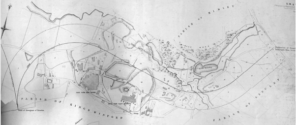
Figure 2. The Oak Farm Works in the 1854 document

Fascinating. Could you improve the resolution of Figure 2 please? Its a bit hard to see. Also the brown on the roads on Figure 1 could be a different colour since they almost look red. Thanks for this research – really interesting.
LikeLike
Thanks for the feedback. I have changed the colour of the roads to a lurid shade of green which at least makes them more visible. There’s not a lot I can do about figure 2 I am afraid, as it depends on the source. But if you want to email me, I will end a pdf.
LikeLiked by 1 person
Fascinating. Could you improve the resolution of Figure 2 please? Its a bit hard to see. Thanks for this research – really interesting.
LikeLike
Wonder if anyone’s given a thought to make this a ‘Midland Metro line’ ,subject to there being enough of it available to make it a viable project ? This would be of a great use to the commuter belt between Dudley/South Staffs/and Wolverhampton were it could link up with other transport links and it would have a ‘green credential’ to it.Would be expensive but its benefit would be megga ! One for Andy Street to ponder on maybiz ?
LikeLike
On this se the following from December 2019 (which seems a lifetime away) https://www.expressandstar.com/news/transport/2019/12/09/survey-launched-on-stourbridge-to-brierley-hill-shuttle-idea/
LikeLike
Do you know if there are any diagrams or photos of track layout for the Smestow Valley/Tettenhall section of the line anywhere? Since I was little I’ve walked/cycled the line and often wondered what the layout may have looked like before the wilderness reclaimed it. I was sat in a tree reading this earlier today and hoped you might know something about where to find more information on the line. Thanks,
Marcus
LikeLike
Have a look at https://www.newrailwaymodellers.co.uk/Forums/viewtopic.php?t=29170#google_vignette for some thoughts from railway modellers. Chris
LikeLike