Preamble
The area known as the Black Country was of course originally rural in character and consisted of fields and woodlands with scattered settlements. However, in the area that lay on the Staffordshire coal field there was ultimately very little land that was left untouched by the direct activities of coal mining and its associated larger areas of spoil, or by the industries that relied on the coal. Coupled with the massive housing developments of recent years, nearly all the rural land in the mining areas of the conurbation has long since disappeared. This is illustrated in the Ordnance Survey Map for the Kingswinford / Pensnett area at the western edge of the Black Country in Figure 1, where there is very little open space to be seen, and what there is, is almost always “made ground” – landscaped former waste and industrial areas.
In this post however I want to draw attention to one small area of land that seems to have escaped the ravages of mining and industry and sustained its agricultural / green space nature into the present. This is contained within the black rectangle of Figure 1 – the are on which currently the Pens Meadow School sits, along with its associated playing fields. We will illustrate this through the use of maps from 1822 to the current day, and on the way draw out some other interesting aspects of this very small area of the Black Country – a sort of micro-history of a very limited area.

Figure 1. The Kingswinford / Pensnett area 2023
The 1822 and 1840 Fowler Maps
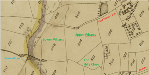
Figure 2. The 1822 Fowler Map
We begin with a map from 1822 in Figure 2 – an extract from the map of Kingswinford parish produced by the firm of William Fowler about which I have written elsewhere. The location of this extract with regard to the wider area is shown by the black rectangle in Figure 1. It basically shows the area to the west of Tiled House Lane and Bromley, both of which are indicated in red. In what follows we will concentrate on the three fields with names shown in green –Upper Wharrs (almost 9 acres); Lower Wharrs (6 acres) and The Hilly Close (3 acres). These were all part of the Tiled House Estate which ran from Commonside to the east, down the south side of Tiled House Lane and extended westward as far as the Standhills area, and southwards as far as Bromley Lane. See here for more information on this Estate. At the time it was owned by the Trustees of the Late Richard Mee, and was suffering from severe financial difficulties. The Wharrs were rented out to Thomas Brettell for farming, and the Hilly Close to James Mullet for similar purposes. Whist the name of The Hilly Close is self-explanatory (it was actually on a region of slightly higher ground than the surroundings), the name of Wharrs is not familiar to modern ears. It’s meaning is something like “land where willows grow” – and thus could be expected to be somewhat damp. The reason for this can be seen in the bottom left of the figure – the Dawley Brook forms in the bottom of the Lower Wharrs. This drains out to the north beneath the Dudley to Kingswinford Road, through what is now Kingswinford Park and out westwards to the River Smestow. Whilst the map is from 1822, in all likelihood these three fields existed within the 1822 boundaries for several centuries before that. It is certainly the fact that the field boundaries in the Corbyn’s Hall estate to the north were unchanged from 1680 (and probably long before) to 1822.
In what follows, I will try to show in what follows that two of these three named fields – Upper Wharrs and The Hilly Close managed to escape the fate of nearly all the fields in the area of being ravaged by mining and the associated spoil heaps, and the later residential development.
On the map of Figure 2, two other features of interest stand out – The Tiled House itself to the east, the site of late 17th century steel making experiments, and the coloured lines to the west. The latter show the course of the Stourbridge Extension Canal that was built in 1837 and did not exist in 1822. At some point in the map’s history (probably before 1837) someone added these lines to the 1822 map, for the purposes of confusing anyone who should try to read it in the 21st century.

Figure 3. The Fowler Map of 1840 – the Tithe map
Figure 3 shows an extract of the same area from the 1840 Tithe Map of the area, again produced by the firm of William Fowler for the pruposes of allocating tithe rentals. The Stourbridge Extension Canal is shown on the left, with the Standhills branch going off the west. There is also a tramway marked that took the products of the Corbyn’s Hall estate to the canal basin at wide waters. It was built in the late 1820s, but in 1837 was purchased by the canal company and decommissioned. It would have been operated by gravity, as there is a considerable slope from north to south, passing beneath the road at Bromley, presumably with horses used to pull the empty wagons back up the slope. Unfortunately, little other information is available about the tramway – for example the nature of its construction, its gauge, truck size and capacity etc.
But despite these developments, the three field under consideration were not affected. They were still owned by the Mee trustees, and all let out to one Walter Dudley. Lower Wharrs was described as pasture with a tithe rental of 3s 4d, Upper Wharrs as meadow with a rental of 6s, and the Hilly Close as Arable land with a rental of £1 – showing the higher value of arable land in comparison to pasture and meadow.
The 1880 and 1900 Ordnance Survey maps
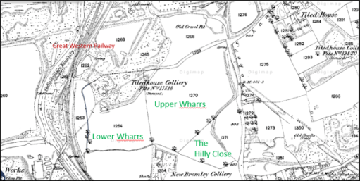
Figure 4. The Ordnance Survey map from the 1880s
By the time of the first large scale Ordnance Survey map in the 1880s (figure 4) the situation had changed significantly, with industrial activities encroaching on the area. The Great Western Railway Kingswinford branch runs to from south to north to the east of the canal. There are disused mines that encroach on the area of the Lower Wharrs (Tiled House Colliery Pits 17 and 18) and to the south of the Tiled House (Tiled House Colliery Pits 19 and 20) with the New Bromley Colliery still operating to the south of Upper Wharrs and Hilly Close. Both of these fields however retain their former boundaries and were still used for farming. Tiled House Lane takes on its modern shape of an east to west portion down from Commonside, although extended further west that it does currently, and a north south portion to the east of Upper Wharrs toward Bromley, although both parts carry the name of Rookery Lane at this time. Indeed, the top half of the north-south portion follows the line of the old Corbyn’s Hall tramway, the extension of which towards Bromley is still visible on the map.
In the Ordnance Survey map from the 1900s of Figure 5 the situation is similar, although the name of Tiled House Lane is attached to its east to west portion and Rookery Lane to its north to south portion. The southern part of the Lower Wharrs and the other two fields still retain their earlier boundaries.

Figure 5. The Ordnance Survey map from the 1900s
The 1930s and 1960s Ordnance Survey maps
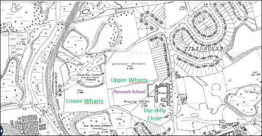
Figure 6. The Ordnance Survey map from the 1930s
Figure 6 shows an Ordnance Survey Map from the 1930s, and there have been significant changes. The Tiled House itself has disappeared, and the Tiled House housing estate in now in existence in its current form. The Pensnett Secondary Modern School has been built, mainly on the Hilly Close, with the southern half of Upper Wharrs as the playing field and the northern half as allotments (behind the houses on Tiled House Lane). The Lane itself has been somewhat straightened out in the process of this development. Nonetheless the combined area of Upper Wharrs and The Hilly Close has retained its integrity and to some degree its agricultural function. The northern half of Lower Wharrs and the area to the south still seems to consist of colliery waste.
One other interesting point to note is that the boundary of the Corbyn’s Hall tramway is marked by the line of the back gardens in the southern cul-de-sac on Tiled House Lane. An archaeological dig in the back gardens of numbers 124 to 130 might well reveal something about the nature of the tramway, but would probably not be much appreciated by the residents. Similarly, the point where the tramway passed underneath Bromley (just outside the current Pensnett / Bromley school entrance) could well retain some evidence of the tramway.
The same situation is illustrated in the aerial view from 1950 shown in figure 7. The view is centred on the Gibbons works on Corbyn’s Hall, but to the top of the picture the outlines of Upper Wharrs and The Hilly Close can be made out, together with both legs of Tiled House Lane.
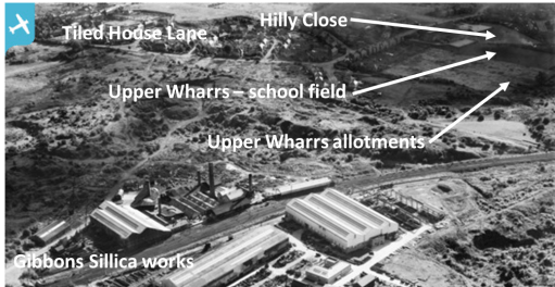
Figure 7 Aerial view from 1950 (from Britain from Above)
The situation is very similar in the 1960s map of figure 8, although the area of the allotments has become a playing field area.
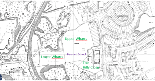
Figure 8. The Ordnance Survey map from the 1960s
The present-day situation

Figure 9. The 2023 Ordnance Survey map
Finally, we come to the present-day situation shown in the up-to-date Ordnance Survey map of Figure 9 and the Google areal view of Figure 10. The school has been replaced by a new entity -the Pens Meadow School in The Hilly Close, and the area of the Upper Wharrs is now playing field or car parks. The eastern portion of Lower Wharrs has been incorporated into the field. The waste area in the north of Lower Wharrs has either been developed for housing or been landscaped as a recreational area. The waste area to the south has been treated in the same way, to give a large green space alongside the railway line.
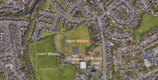
Figure 10. An aerial view of the current situation (from Google maps)
It can thus be seen from these maps it can be seen that the area of Upper Wharrs and the Hilly Close represents a remarkable survival of a “land unit” that, in the main escaped the ravages of mining and waste and has retained, to a large degree, its “green” character. It also suggests that the name of the school currently on the site should either be “Hilly Close school” or perhaps even the “Wharrs school”. I doubt the second would be much appreciated by parents, teachers or children.

One thought on “The fields that survived”