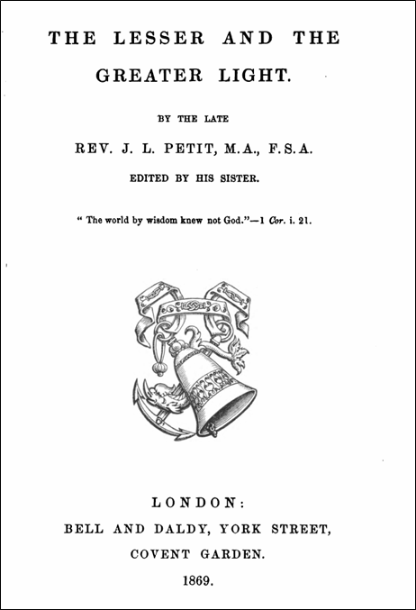
John Louis Petit was an Anglican clergyman, ordained deacon in 1825 and priest in 1826, both at Lichfield Cathedral. He served two curacies – the first from 1825 to 1828 at St. Michael’s Lichfield and the second from 1828 to 1832 at Bradfield in Essex. He then retired from parish ministry to concentrate on his artistic and architectural interests. He remained a priest however, and was much interested in the theological developments of the mid-19th century – in particular the revelations of the earth and astronomical sciences. At his death he left a long unfinished poem “The lesser and the greater light” that was a meditation of the relationship between theology and science, which was edited and published by his sister. This poem has many contemporary echoes and reveals that Petit was a serious theological thinker.
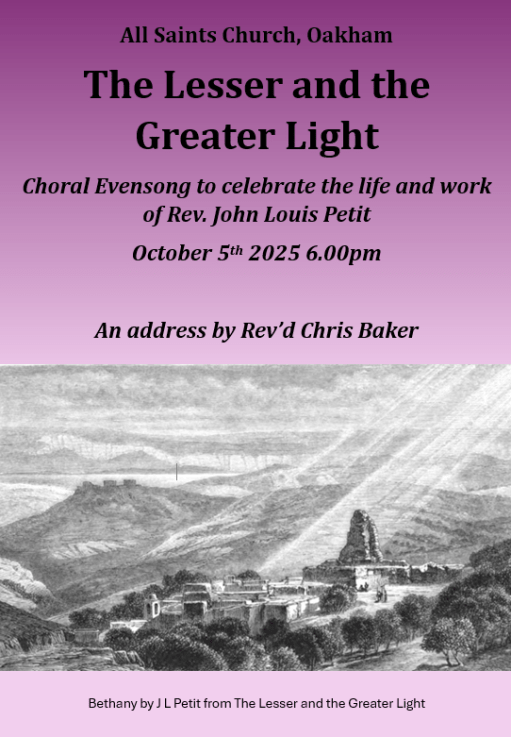
To celebrate and reflect on Petit’s role as a clergyman and theologian, a Choral Evensong was held at All Saints church at 6.00pm on Sunday October 5th with the service sung by the Laudamus (Oakham Team Ministry) choir. The choral setting and hymns reflected Petit’s period and an address was delivered by Revd. Professor Chris Baker on the subject matter of “The lesser and the greater light” and its implications for both the Victorian period and for today. All Saints church was itself heavily restored by Gilbert Scott in the 1850s.
In this post we gather together some material associated with the event – the advertising poster, a copy of The Lesser and the Greater Light, the Order of Service and a transcript of the address.
Evensong flyer
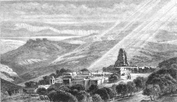
The Lesser and the Greater Light (from Google Books)
An Exhibition of the East Midlands paintings of John Louis Petit was held at Rutland County Museum from August to October 2025. During the preparation for that exhibition, I looked at whether the scenes that Petit painted were still recognisable today, and built up a collection of “then and now” photographs. Some of these have already appeared on various social media channels. In this post I show around 20 such comparisons and give brief notes as to locations and vantage points. Some of the modern photographs were taken by me, whist others were taken from publicly available sources. They are divided into the four sections used in the exhibition – Leicestershire and Rutland, Peterborough and Northamptonshire, Lincolnshire and Cambridgeshire and Further Afield. I hope they will be of interest to some readers.
(Click on the pictures for full view versions)
Leicestershire and Rutland
St Mary de Castro, LeicesterSt Martin’s, LeicesterSt Luke’s, ThurnbySt Mary’s, Melton MowbrayKirby Muxloe CastleOakham Castle and All Saints ChurchOakham ButtercrossSt Peter and St Paul, Exton
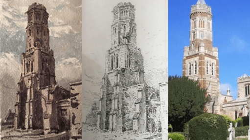
St. Mary de Castro, Leicester – JLP 1845, Author 2025. The obvious difference between the 1845 and the modern picture is the lack of a spire- this was removed for safety reasons in 2013.
St Martin’s, Leicester – JLP 1845, Author 2025. St Martin’s became Leicester Cathedral in 1927 and has been considerably extended since Petit’s day, not least with the bones of Richard III. The 1845 view is now much obscured by trees and the new work.
St Luke’s, Thurnby – JLP 1845, Tim Glover, Creative Commons license. Petit painted his picture in the period in the period the church was without its chancel. The church was substantially rebuilt in 1870 by Slater and Carpenter with a new chancel and south aisle.
St Mary’s, Melton Mowbray – JLP 1850, Author 2025. Obtaining the modern picture required sitting on the ground at low level in a car park. One hopes the ground level was different in Petit’s day. There are some interesting differences between the pictures – specifically a door in the right hand aisle in Petit’s picture, and one in the left hand aisle in the modern picture – perhaps as a result of the restoration by Scott of the 1860s and 70s?
Kirby Muxloe Castle – JLP 1845, Ashley Dace 2010, Creative Commons license. The pictures are from very similar vantage points, and show little difference in the tower.
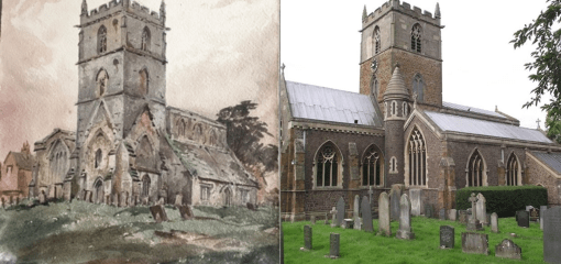
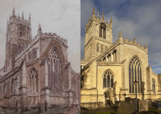
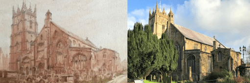
Oakham Castle and All Saints Church – JLP 1850, Author 2024. Both pictures are from the same vantage point. The major difference between them is the extent of the outbuilding on the right hand side.
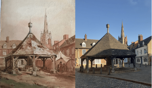
Oakahm Buttercross – JLP 1850, Author 2024. Again the pictures are from very similar, but not identical positions – the position from which Petit painted is now behind a hedge in the Oakham School grounds. The house roof lines and windows in the background are very similar. The building on the right hand side in 1850 has been replaced by the Sorting Office in the modern photograph.
St Peter and St Paul, Exton – JLP 1845, Author 2024. The locations of the two pictures are similar but not identical – to achieve Petit’s position would have required climbing over a fence and a boundary between the churchyard and the Exton Estate of the Gainsborough’s. The photograph was taken from very close to the church and significant perspepctive correction was required.
Peterborough and Northamptonshire
St Andrew’s, NorthboroughSt Peter’s, IrthlingboroughSt Mary’s, Higham FerrarsSt Kynerburghia, CastorPeterborough Cathedral, North AislePeterborough Cathedral, North Tower Pinancle
St Andrew’s, Northborough – JLP 1841, J Haywood, Creative Commons Licence 2025. The Petit line drawing is from his book “Remarks on Church Architecture” from 1841. The two views are very similar
St Peter’s, Irthlinborough – JLP 1830,1841, Discover Northampton 2025. The line drawing is again from “Remarks on Church Architecture”, and was drawn for the 1830 painting. The tower in the modern picture shows the results from a major rebuild in the 1890s.
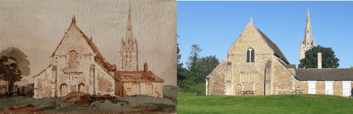
St Mary’s, Higham Ferrars – JLP 1830, Bearas 2024, Creative Commons license 2025. The major change here is to the chancel which was substantially rebuilt with a lower roof in the 19th century.
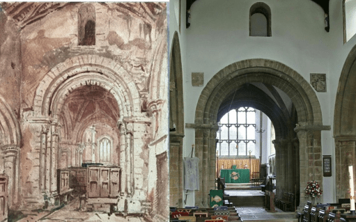
St Kynerburghia, Castor – JLP 1845, Alan Murray-Rust, Creative Commons license 2016. Both painting and photograph are from a position below the central tower. Petit’s painting shows a much more cluttered interior in the chancel area – possibly indicating an Elizabethan communion room arrangement.
Peterbrough Cathedral North Aisle – JLP 1845, Author 2024. The modern picture shows the location of the tomb of Catherine of Aragon. This was behind the screen that fills the aisle in the 1845 painting.
Peterborough Cathedral North Tower Pinnacle – JLP 1845, Author 2025. Petit painted the pinacle on the north tower from a location on the roof of the tower itself. It is looking east along the nave and chancel. I had neither the access or the inclination to get to the same vantage point, so the modern photo is from ground level, looking west from the side of the north aisle.
Lincolnshire and Cambridgeshire
Crowland AbbeySouth KymeSt Peter and St Paul, WisbechCrowland Trinity Bridge
Crowland Trinity Bridge
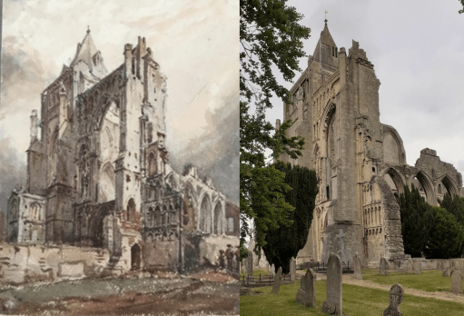
Crowland Abbey – JLP 1845, Author 2025. The location of the 1845 picture, possibly one of Petit’s most impressive, is now in the midst of a clump of trees, so the modern picture is from a slightly different location. The tree growth around the Abbey is significant.
South Kyme – JLP 1845, British Express 2025. The vantage points of both painting and photograph are very similar – and the tower has changed little in the interim.
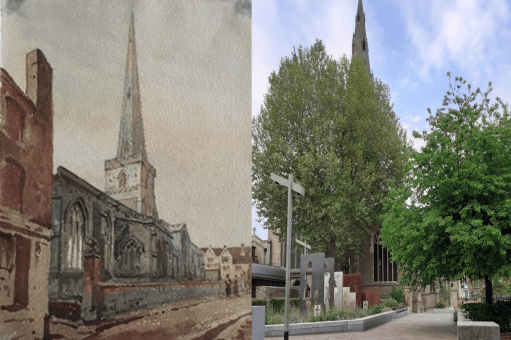
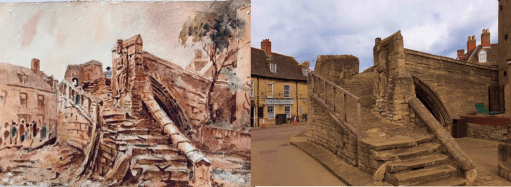
Crowland Trinity Bridge – JLP 1861, Author 2025. I managed to take the photo of Trinity Bridge in Crowland from almost the exact position from which Petit painted it and it can be seen the bridge is little changed. However Petit did not have to contend with cars and lorries wanting to occupy the same space.
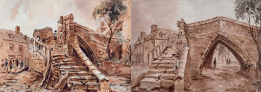
Crowland Trinity Bridge – JLP 1861(x2). Finally I include a comparision of two pictures of Trinity Bridge in Crowland, almost certainly painted on the same day from slightly different vantage points. The right hand picture has recently been sold on eBay and is a screen shot from that site. The very similar representations of detail is astonishing, showing the accuracy of Petit’s representations.
Further afield
Crystal PalaceLocmariaquer
Both of these pictures are not really “then and now” – more “then and then” – and show the view that Petit painted against other historical views.
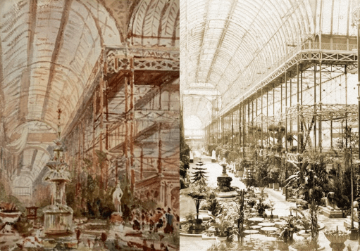
Crystal Palace – JLP 1867, Historic England 1859. The views are from similar vantage points, but show different exhibits in the same space. Comparing Petit’s painting of the superstructure with the photograph shows the accuracy of his representation.
Locmariaquer – JLP 1851, Postcard c 1900, Cartorum, Jules Coignet 1836, Public Domain. Petit painted his view of the dolmen at Locmariaquer in 1851. The painting by Jules Coignet is 15 years earlier, and the postcard view around half a century later. The similarities is in the rock formation in all three are striking, indicating again something of the accuracy with which Petit painted.
Closing Remarks
Perhaps the major point to emerge from this exercise for me is how Petit seems to have painted views from vantage points that were difficult to access, or from locations that most others would not have chosen. There are many churches for which I have not been able to make a comparison of Petit’s picture with the modern day situation, simply because there seem to be no published photographs from the location Petit used. He seems to have sought out the unusual viewing points.
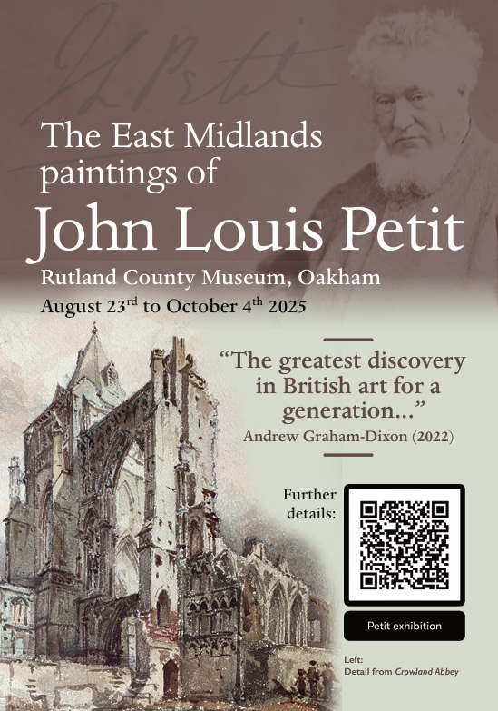
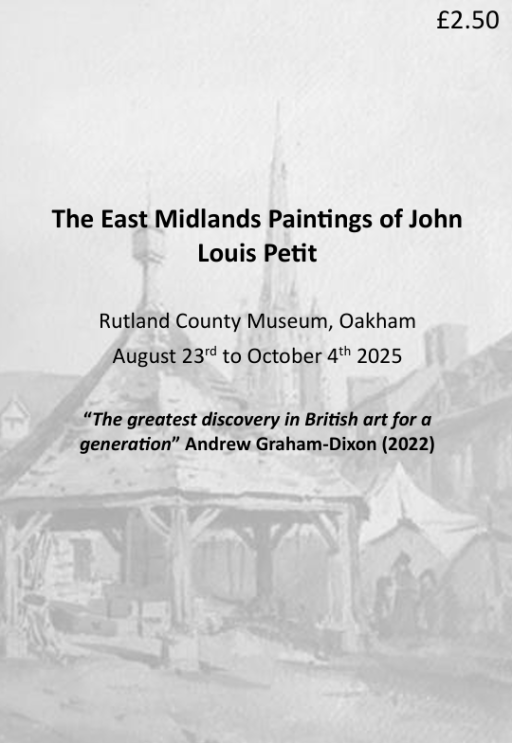
Rutland County Museum, Oakham, August 23rd to October 4th, 2025
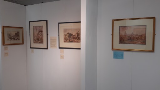
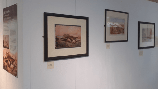
During his career Petit painted many thousands of pictures, but his work was never sold, and after his death in 1868, they were passed on to relatives. A century later they were discovered in an attic in Surrey, dumped in auctions and were widely scattered. Only now is their artistic merit and historical value being recognised. The art critic Andrew Graham-Dixon the greatest re-discovery in British Art for a generation, and the first book about his art, by the chairman of the Petit Society, describes him as Britain’s lost pre-impressionist. Petit’s art of the East Midlands is part of this re-discovery. Close to his home base in Lichfield, Petit visited and painted across the region many times. Often, he paints locations and subjects no other historical artist touched. Some 40 of these pictures were gathered together to be shown to the public for the first time ever at an exhibition held in Rutland County Museum between August and October 2025.
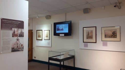
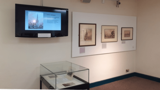
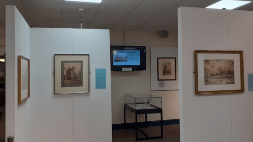
In this blog post we gather together a range of material related to the exhibition – the advertising material and display boards; photographs of the exhibition area itself; and the exhibition catalogues and slideshow that was shown on the screen in the exhibition area.
Exhibition flyer and display boards
Exhibition flyer
Exhibition display boards
The flyer formed the basis of advertising the exhibition and was widely distributed by email and Social Media, with a small number of hard copies distributed locally around Oakham. There were five display boards – a general introduction (A1) and four others relating to the four geographical sections of the exhibition – Leicestershire and Rutland, Northampton and Peterborough, Lincolnshire and Cambridgeshire and Further Afield (A2).
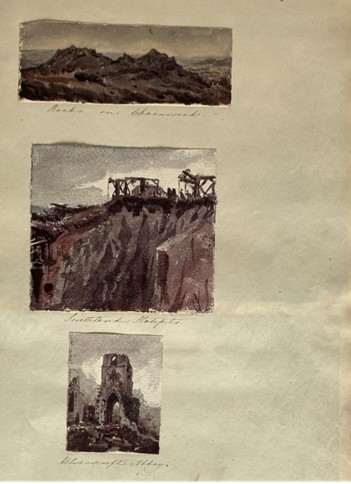
The simply produced catalogue contained brief details and a small photos of all the pictures that were planned to be exhibited. In the event a small number were not hung due to space limitations. These were shown as a slide presentation on a screen in the exhibition area, together with pages from an 1830 Album (see catalogue for description) and a selection of other East Midlands paintings.
Exhibition Catalogue
Slide show
Acknowledgements
The contributions of the following groups of people to the success of the exhibition need to be mentioned – the sponsors who provided much needed financial support; those friends of the organisers who helped with transport, mounting pictures and catering at the opening event; those who loaned paintings that were shown (identified in the catalogue); and most importantly the staff at Rutland County Museum for making the exhibition space available and constructing the exhibition. The help of all of them is very gratefully acknowledged.
This article first appeared in the Summer 2022 edition of the Blackcountryman. Unfortunately a number of figures were omitted and some other figure captions were incorrect. The electronic version of that edition on the web site contains a correction page, and the full corrected article is given here for convenience.
Preamble
The “Gothic Revival” In church architecture in the mid-nineteenth century was largely driven by the Ecclesiological Society, formed in 1839, the members of which were insistent that the only proper design of church building was the decorated gothic style of the middle ages. Proponents of this style included Augustus Pugin and Gilbert Scott and many of the Anglican churches that were built in the second half of the nineteenth century reflected these principles. There were however, a small but vociferous opposition who advocated careful preservation of medieval buildings and that new work should build on and complement earlier styles. The arguments between the factions reached a quite astonishing level of intensity and vitriol. For example, the rather unpretentious chancel of St. Michael’s church in Lichfield, which will be referred to in what follows, was described by the local branch of the Ecclesiological Society as “…a hideous and unnecessary aftergrowth… so substantial a deformity….” and was duly rebuilt in the proper style. It can be fairly said that the Ecclesiologists won the argument at the time, and as ever, the history of the period was written by the winners, so the views of their opponents get little coverage. Tastes change however, and the work of those who favoured an evolutionary approach to church architecture is once again beginning to be appreciated.
One of these was the Rev. John Louis Petit (1801-1868), a talented watercolourist, who painted hundreds of pictures of churches in Britain and around Europe that were used to illustrate the talks that he gave to large audiences. His paintings were never sold commercially and have only recently begun to be discovered and publicly exhibited by the Petit Society. The website of the Society (http://revpetit.com) gives a huge amount of detail about the development of his quite unique style that somehow captures the emotional impact of the church buildings he drew.
From a Black Country point of view however, John Louis Petit and his family are also of interest in two ways. First of all the Petit family derived much of their considerable wealth from the Ettingshall Park Estate in Sedgley, where one of them was responsible for the building of the folly we know as Sedgley Beacon. Secondly, John Louis also painted a small number of Black Country industrial scenes which show very early, and accurate, representations of the iron and coal industry. We consider both these aspects in what follows. First however we give a brief history of the Petit family.
The Petit family
The first of the Petit family to arrive in England was Lewis Petit (1665-1720), a member of the ancient Norman family of Petit des Etans, who, with many other Hugenots, fled to England from Caen on the revocation of the Edict of Nantes in 1685. He served in the British army as an engineer, rose to the rank of brigadier-general and was appointed lieutenant-governor of Minorca from 1708 to 1713. One of his two sons, John Peter Petit, married Sarah, daughter of John Hayes of Wolverhampton, the owner of the Ettingshall Park Estate near Sedgley. John Hayes died in 1736, and left Ettingshall to his son, another John Hayes. This John himself died in 1745 and the estate went to Sarah and her sister, and thus ultimately to John Peter Petit. Ettingshall Park was a large, originally arable estate, that even at that stage was beginning to be exploited for its coal and ironstone reserves. It is from that estate that much of the Petit wealth derived.
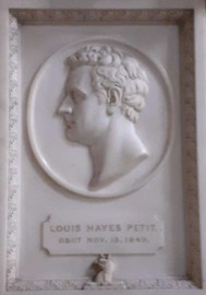
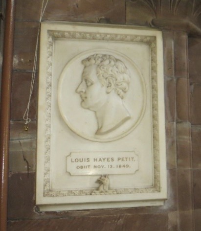
John Peter and Sarah’s only son, John Lewis Petit (1736-1780) qualified as a doctor in 1767 and was physician to St. George’s Hospital from 1770 to 1774, and to St. Bartholomew’s from 1774 until his death. He and his wife Katherine had three sons John Hayes Petit (1771-1822), Peter Hayes Petit (1773-1809) and Louis Hayes Petit (1774-1849), but clearly lacked imagination in the giving of names. Peter was a lieutenant-colonel of the 35th Foot and died of a wound received at Flushing in Holland during the Napoleonic war. Louis became a barrister and, from 1827 to 1832, was MP for Ripon. After ceasing to be an MP, his remaining years were largely devoted to literary and philanthropic pursuits. There is a striking monument to him in St. Michael’s church in Lichfield.
The monument to Louis Hayes Petit in St. Michael’s church in Lichfield
The eldest of the three brothers, John Hayes Petit (1771-1822) inherited the Ettingshall Park estate, but also followed an ecclesiastical career. He was ordained priest in Chester in 1798 and served a curacy at Ashton under Lyme near Stalybridge in Cheshire. During his time there he married Harriet Astley of the nearby town of Dukinfield. Harriet was born in 1779 to the painter John Astley (1724-1787) and his third wife Mary Wagstaffe (1760-1832). John Astley had a colourful life, painting portraits of many 18th century notables, arousing strong passions of admiration (mainly in women) or distaste (mainly in men). His first wife was an unknown Irish lady who died in 1749. The second was Penelope Dukinfield Daniel (1722–1762) widow of Sir William Dukinfield Daniel, 3rd baronet, and a daughter of Henry Vernon, former High Sheriff of Staffordshire. John and Penelope were married with some rapidity after she intimated that the original of the portrait he was painting of her would be available if he wished. On Penelope’s death, and the death of his stepdaughter, Astley inherited the substantial Dukinfield and Daniel estates in Cheshire and Staffordshire and was able to lead a life of some luxury and idleness thereafter. Harriett was one of three sisters, known as the Manchester beauties, and her marriage to John Hayes Petit would have brought him both a beautiful wife and a substantial supplement to his already considerable income.
In 1811 John was appointed Curate of Donnington, and then in February of that year he was also appointed as a Perpetual Curate at Shareshill, to the north-east of Wolverhampton. As well as the Ettingshall estate, he also owned considerable areas of land in Wolverhampton and south Staffordshire. Around 1817 he leased Coton Hall at Alveley in Shropshire, which was a very substantial property that belonged to the Lee family (from whom the US Confederate General Robert E Lee was descended). It would not have been a cheap place to lease. After John Hayes Petit’s death in 1822, Coton Hall was bought by James Foster (1786 -1853), the very successful and wealthy ironmaster and coalmaster of Stourbridge.
John Louis Petit
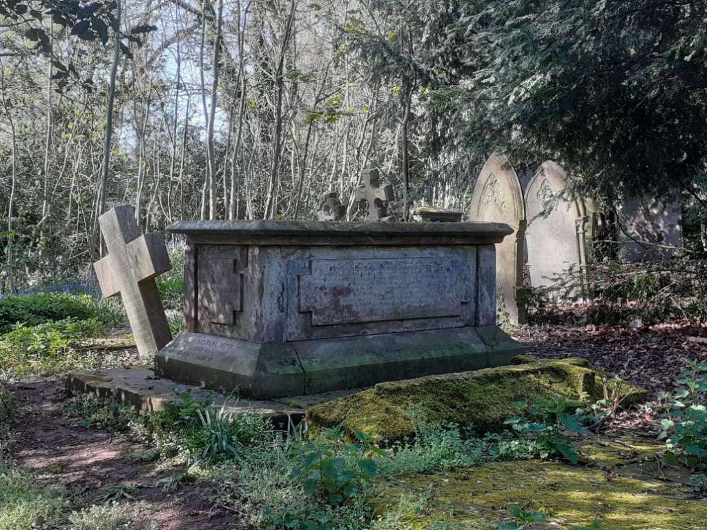
John Louis Petit, the artist, born in 1802, was the eldest of John and Harriet’s nine children. He inherited the Ettingshall estate on the death of his father in 1822, and also inherited the bulk of the estate of his uncle Louis Hayes Petit when the latter died in 1849. In total they formed a very substantial estate in the Wolverhampton area, that was being heavily exploited for coal, iron ore and limestone. He and his sisters also had a less tangible inheritance from his mother and his grandfather – the passion and the ability for painting and sketching. After he graduated from Trinity College in Cambridge in 1825, John Louis Petit firstly pursued an ecclesiastical career being curate at St Michael’s in Lichfield from 1825 to 1828, and then curate at Bradfield and Mistley in Essex from 1828 to 1834. He married Louisa Reid, the daughter of George Reid of Trelawny in Jamaica in 1828. The Reid family derived much of their wealth from slave plantations in Jamaica and the family received considerable compensation for their lost income when slavery was abolished in the 1830s. He gave up his post in Essex in 1834 and from the mid-1830s onwards he devoted his time to his painting and architectural criticism, and his story is well told on the website of the Petit Society. He died in 1868 and is buried with a number of his relatives, in a large tomb in St. Michael’s churchyard, where a display board has recently been placed outlining his career.
The grave of John Louis Petit and his family in St. Michael’s churchyard
The Ettingshall Park Estate
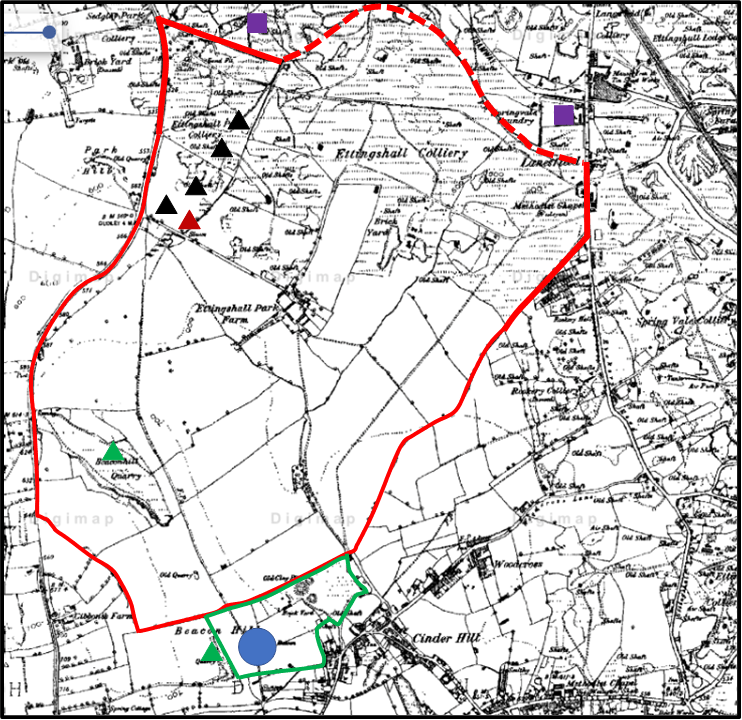
The extent of the lands owned by Join Louis Petit in Ettingshall in the 1840s are shown on the map below. The estate boundaries are taken from the Tithe Allocations and are superimposed upon the 1882 Ordnance Survey map of the area. The estate was in the north of Sedgley parish, just south of the Wolverhampton boundary and the holding was 413 acres in total. It is centred on Ettingshall Park farm and lies west of another large estate – that of Ettingshall Hall. A small block at the south of the estate was owned by his uncle and former MP, Louis Hayes Petit until his death in 1849. Most of the land, even at that stage was arable or pasture. There were a small number of collieries to the north-west, and two lime workings at Round Hill and Beacon Hill. However just beyond the estate heavy industry was beginning to encroach, with the Spring Vale Ironworks to the north-east and the Parkfields iron works to the north. The former was served by basins from the Birmingham Canal (as indeed were most ironworks in the area). The underlying 1882 Ordnance Survey map shows a similar situation in the south of the estates, with most of the field boundaries being identical to those on the tithe map, but in the north mining activities have completely eliminated the fields (and indeed makes the estate boundary difficult to determine) and indeed many of the roads shown on the tithe map. In effect the area of mining in the 1880s came right to the edge of the South Staffordshire Coal Field.
The Ettingshall Park estate. (The lands owned by John Louis Petit in the 1840s are outlined in red, and those owned by Louis Hayes Petit in green. Black triangles – collieries; red triangles – ironstone pits; green triangles – lime works; purple squares – iron works; blue circle – Sedgley Beacon
Although John Louis owned the land, he leased it to others. The central area around Ettinghsall Park Farm was leased to Dudley Fereday, with smaller agricultural plots leased to Edwin Dixon, William Fletcher and Edward Jay. The mines and pits were operated by George Jones, John Neve and Co., or the Parkfields Company who operated the nearby ironworks. Essentially we see here, as in so many places in the western Black Country at this time, the transition from a farming to an industrialised way of life.
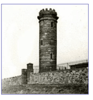
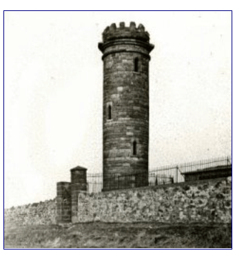
As noted above Louis Hayes Petit owned some land to the south of the Ettingshall estate. This encompassed the highest point in the locality at Beacon Hill. It was on this hill in 1846 that the Beacon Tower was erected, which still stands if in a somewhat dilapidated state. The Sedgley Local History society attributes the building of this tower to “a local landowner, Mt Petit”, although it might have been used for astronomical observations by Lord Wrottesley a well-known Staffordshire amateur astronomer. Whether this was John Louis or Louis Hayes is not clear, but perhaps we have here the architectural critic dabbling in architecture himself, if only in the construction of what can probably fairly be described as a folly.
Sedgley Beacon (from the Sedgley Local History Society website)
The Black Country pictures
Most of John Louis Petit’s artistic work was directed at painting churches for use in his talks and arguments with the Ecclesiologists. However, he also painted a small number of scenes of Black Country industrial activity during his career, and these will be discussed in what follows. All are reproduced with permission of the Petit Society. I do not consider their artistic merits – indeed I would be quite incapable of doing so – but rather I will discuss the scenes the paintings portray and the locations from which they might have been painted. Three of these come from the early 1830s and one from the 1850s.
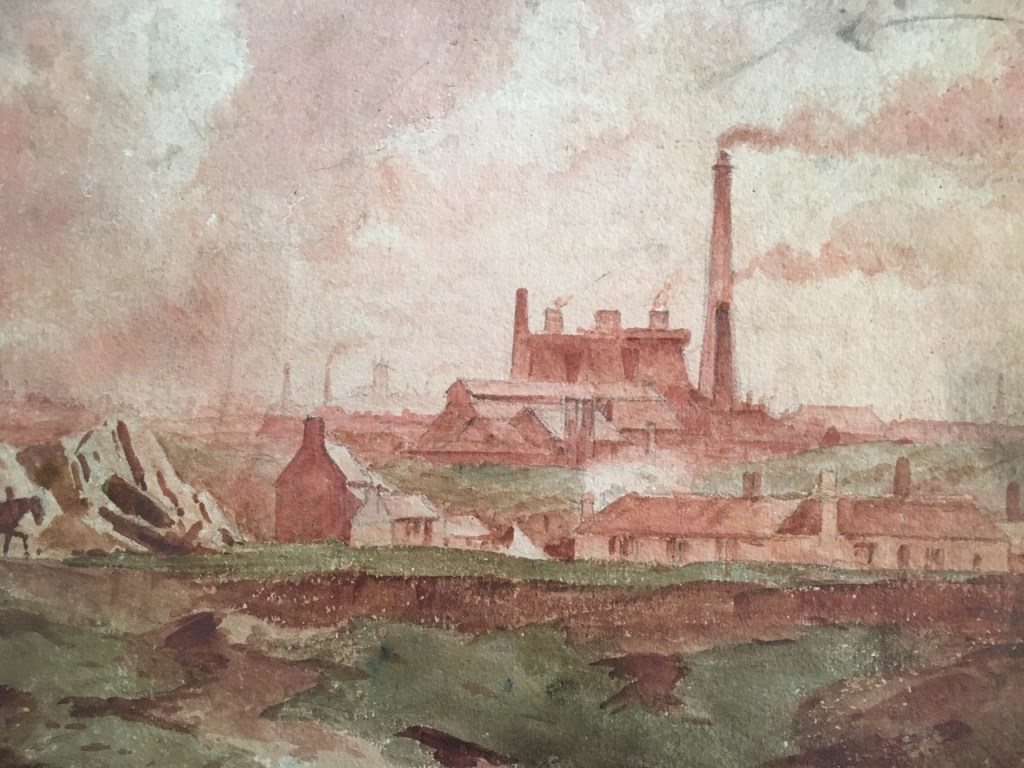
Spring Vale iron works from the Penn brook (?), early 1830s
The first shows an ironworks in the distance, framed by a much more rural location. My best guess for this is that it is a representation of the Spring Vale Iron Works, or perhaps the nearby Parkfield works, seen from the western side of the Ettingshall estate at a location on the headwaters of the Penn brook (which leads into the Wom brook, and then into the Smestow). Little detail of the works can be seen although the furnaces and chimney can be seen. The painting is of interest as showing the juxtaposition of rural and industrial elements.
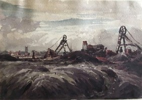
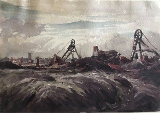
Mines near Wolverhampton (?) c1830-35
The second painting is again dated in the early 1830s. The main feature is the pair of pits showing the scaffoldings of the “Rattle Chain”. This is a very early representation of such mechanisms. The nature of the structure between the scaffoldings is not clear but could perhaps be some sort of furnace or processing plant. The grim reality of the destruction of the surrounding countryside by spoil from the mines is also very apparent in the foreground. The figures of two mine workers wearing brimmed hats can also be seen. Nothing by way of safety equipment was provided and there were many injuries and deaths, which were simply regarded as part of the costs of the operation.
In the background there are two churches shown, one with a tower and one with a spire. At first sight they would seem to show the Wolverhampton churches of St. Peter’s to the left with the tower, and St. John’s to the right with the spire. The former was a favourite subject of Petit. However, this placing of the churches suggest that the scene was painted from the west of Wolverhampton, as St. Peter’s is to the north of St. John’s. This however is not possible, as there were simply no mines in this region – indeed the boundary of the south Staffordshire coal field is to the east of the town. We are left with two possibilities – either the artist added the church towers to a scene painted from elsewhere to contrast the old and the new (which of course as a painter he was perfectly at liberty to do), or the painting depicts a scene from elsewhere. In terms of other locations, I can find only one other location in the vicinity from which a church tower and spire could be observed – somewhere to the west of Dudley where St. Edmund’s and St. Thomas’s churches are so aligned. This would give a location for the pits somewhere in the Gornal area, which would be quite possible, being close to the Ettingshall Park estate. However, if this were the location, one would have expected Petit to have skewed the scene slightly to show Dudley Castle, which would be just off the left of the current picture. There may however be alternative possibilities that I have not identified in the Wolverhampton area. Reader’s thoughts would be very welcome.
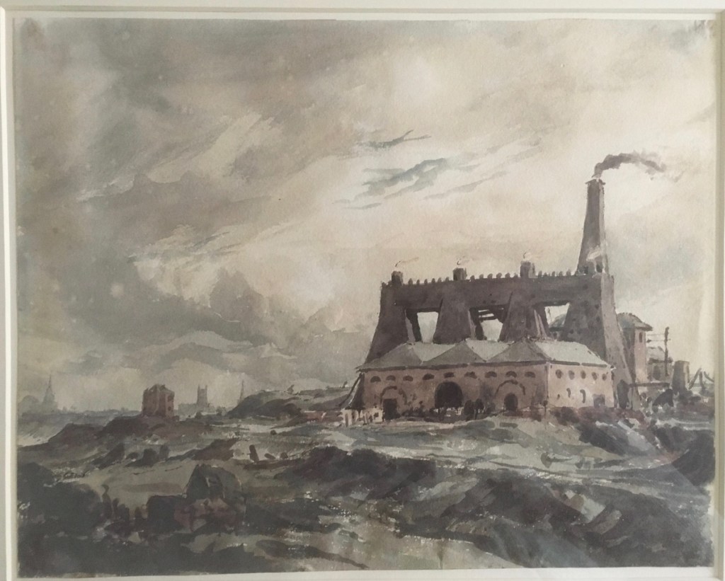
Iron works in the Bilston area, early 1830s
The third picture shows an ironworks with four furnaces. The position of the two churches in the background, the one with the spire and the one without, again matches St Peter’s and St John’s in Wolverhampton and their relative position suggest that the picture was painted from the south-east in the Bilston area. The level of details it shows is remarkable. The furnaces themselves can be clearly seen, together with quite detailed depictions of ancillary buildings in the foreground. It would be interesting to know the function of these buildings. There are perhaps impressionistic indications of tram tracks and a canal basin in the right foreground, although this is very conjectural.
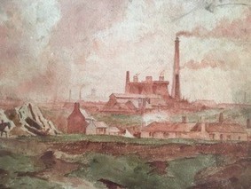
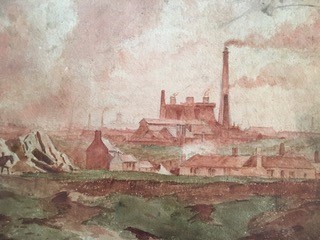
Springvale Ironworks, Bilston
This final picture is believed to have been painted in 1852 or 1853 and to depict the Springvale Ironworks at Bilston to the south east of Wolverhampton. It clearly shows a number of blast furnaces and other industrial buildings. In the foreground there is the depiction of a small housing settlement. The land here is greener than in the Wolverhampton painting, but still broken, looking as if it had been used for some extraction activity. The horses walking along the foreground track again give the contract between the old and the new. In the background we can see the chimneys of the Black County and perhaps, just to the left of the furnaces, a depiction of a church tower. The position from which the picture is painted can be more precisely defined from a consideration of the Tithe Map as somewhere in the vicinity of the junction of the current Parkfield Road with the Dudley / Wolverhampton Road. The painting position sits just outside John Louis Petit’s Ettingshall estate, and one can conjecture that the picture was painted on a trip to the estate to conduct whatever estate business was required with his agent and tenants.
One of the many things that intrigue me about the work of Petit is its breadth that ranges from the type of scene in these pictures to his more usual output of sometimes quite idyllic churches. I wonder if he saw, in the size and functional architecture of blast furnaces, the same grandeur that he perceived in many of the churches that he drew, an, in his mind at least, the stark differences between churches and blast furnaces were not as significant as the similarities. This is to some degree borne out by a quote from him made at an Architectural Exhibition – On Utilitarianism in 1856 at which the picture of Spring Vale Iron Works was probably exhibited.
“Usefulness and economy may not only be consistent with artistic excellence, but actually tend to the development of much that is grand and beautiful. If picturesqueness is a merit, I can answer for it that the most picturesque objects I have seen are buildings of the most strictly utilitarian character, without a speck of ornament, and you may be sure erected at no more cost than was deemed necessary, without the slightest attention whatever to appearance. I speak of the furnaces in the neighbourhood of Wolverhampton. Some of these taken as buildings independently of their accompaniments of fire and smoke, are absolutely grand. There is something, too, very impressive, to my mind, in the lines of modern fortification…’
This led to strong correspondence with Gilbert Scott who attacked him for admiring ‘railway sheds’ and factories!
Finally, for those interested in Petit’s primary work on church architecture, the book “Petit’s Tours of Old Staffordshire” by Philip Modiano is an excellent place to start. It is of course available on Amazon.
Since this article appeared in print in its uncorrected form, the author has been in correspondence with Ray Shill, who has written widely on the Black Country iron industry. The most important point to emerge from this correspondence has been the ambiguity around the name of Springvale ironworks and foundry. In the earliest references to these works the names Bilston, Coseley and Spring Vale ironworks and furnaces are used to refer to a variety of different works in the immediate area. So care is needed when considering any attribution of a name to one of the paintings shown above.
This post appeared in the April 2022 edition of the St. Michael’s church magazine. It is a selection from a number of earlier posts that discuss the Petits that can be accessed here and here.
The monument commemorating Louis Hayes Petit is very prominent at the front of the nave in St Michael’s, and recently a display board commemorating the life and work of his nephew, John Louis Petit has been erected in the graveyard close to the tomb of him and his siblings. But who were the Petit’s? In this short article I will give a brief history of the family from the time they first left France up to the death of John Louis and his siblings in the late nineteenth century.
The monument to Louis Hayes Petit in St Michael’s church
The first of the Petit family to arrive in England was Lewis Petit (1665-1720), a member of the ancient Norman family of Petit des Etans, who, with many other Hugenots, fled to England from Caen on the revocation of the Edict of Nantes in 1685. He served in the British army as an engineer, rose to the rank of brigadier-general and was appointed lieutenant-governor of Minorca from 1708 to 1713. He was later involved in the suppression of a revolt by Highland clans. He had two sons, John Peter Petit and Captain Peter Petit. The former married Sarah, daughter of John Hayes of Wolverhampton, the owner of the Ettingshall Estate near Sedgley, and they occupied the manor of Little Aston from 1743 to the early 1760s. John Hayes died in 1736, and left Ettingshall to his son, another John Hayes. This John himself died in 1745 and the estate went to Sarah and her sister, and thus ultimately to John Peter Petit. Ettingshall was a large, originally arable estate, that even at that stage was beginning to be exploited for its coal and ironstone reserves. It is from that estate that much of the Petit wealth derived.
John Peter and Sarah’s only son, John Lewis Petit (1736-1780) qualified as a doctor in 1767 and was physician to St. George’s Hospital from 1770 to 1774, and to St. Bartholomew’s from 1774 until his death. He was a Fellow of the Royal Society from 1759 and was clearly regarded as a leader in his profession. He and his wife Katherine had three sons John Hayes Petit (1771-1822), Peter Hayes Petit (1773-1809) and Louis Hayes Petit (1774-1849), but clearly lacked imagination in the giving of names. Peter Hayes was a lieutenant-colonel of the 35th Foot and died of a wound received at Flushing in Holland during the Napoleonic war. Louis Hayes (he of the monument) became a barrister and, from 1827 to 1832, was MP for Ripon. He bought property at Yeading, Middlesex, and a house in Tamworth Street, Lichfield. After ceasing to be an MP, his remaining years were largely devoted to literary and philanthropic pursuits.
The eldest of the three brothers, John Hayes Petit (1771-1822) inherited the Ettingshall estate, but also followed an ecclesiastical career. He was ordained priest in Chester in 1798 and served a curacy at Ashton under Lyme near Stalybridge in Cheshire. During his time there he married Harriet Astley of the nearby town of Dukinfield. Harriet was born in 1779 to the painter John Astley (1724-1787) and his third wife Mary Wagstaffe (1760-1832). John Astley had a colourful life, painting portraits of many 18th century notables, arousing strong passions of admiration (mainly in women) or distaste (mainly in men). His first wife was an unknown Irish lady who died in 1749. The second was Penelope Dukinfield Daniel (1722–1762) widow of Sir William Dukinfield Daniel, 3rd baronet, and a daughter of Henry Vernon, former High Sheriff of Staffordshire. John and Penelope were married with some rapidity after she intimated that the original of the portrait he was painting of her would be available if he wished. On Penelope’s death, and the death of his stepdaughter, Astley inherited the substantial Dukinfield and Daniel estates in Cheshire and was able to lead a life of some luxury and idleness thereafter. Harriett was one of three sisters, known as the Manchester beauties, and her marriage to John Hayes would have brought him both a beautiful wife and a substantial supplement to his already considerable income.
In 1811 John Hayes Petit was appointed Curate of Donnington, and then in February of that year he was also appointed as a Perpetual Curate at Shareshill, to the north-east of Wolverhampton. Around 1817 he leased Coton Hall at Alveley in Shropshire from Harry Lancelot Lee, which was a very substantial property that once belonged to the Lee family. In 1636, Richard Henry Lee had emigrated to the US, and the family became rich through the ownership of tobacco plantations with a large slave population, and from whom the US Confederate General Robert E Lee was descended. It would not have been a cheap place to lease. After John Hayes Petit’s death in 1822, Coton Hall was bought by James Foster (1786 -1853), the very successful and wealthy ironmaster and coalmaster of Stourbridge. After his death his wife Harriet and her unmarried daughters moved to the house in the house in Tamworth St, Lichfield that was owned by her brother-in-law Louis Hayes Petit.
John Louis Petit
John Louis Petit, the artist, born in 1802, was the eldest of John and Harriet’s nine children. He inherited the Ettingshall estate on the death of his father in 1822, and also inherited the bulk of the estate of his uncle Louis Hayes Petit when the latter died in 1849. In total they formed a very substantial estate in the Wolverhampton area, that was being heavily exploited for coal, iron ore and limestone. He and his sisters also had a less tangible inheritance from his mother and his grandfather – the passion and the ability for painting and sketching.
After he graduated from Trinity College in Cambridge in 1825, John Louis Petit firstly pursued an ecclesiastical career being curate at St Michael’s in Lichfield from 1825 to 1828, under the Perpetual Curate Edward Remington, and then curate at Bradfield and Mistley in Essex from 1828 to 1834. During his time at St. Michael’s, the registers tell us he carried out 61 baptisms, 35 weddings and 163 funerals, as well as presumably leading the Sunday worship – a not inconsiderable load. He married Louisa Reid, the daughter of George Reid of Trelawny in Jamaica in 1828. The Reid family derived much of their wealth from slave plantation ns in Jamaica and the family received considerable compensation for their lost income when slavery was abolished in the 1830s.He gave up his post in Essex in 1834 and from the mid-1830s onwards he devoted his time to his painting and architectural criticism, and his story is told elsewhere. His artistic career is well described on the website of the Petit Society – http://revpetit.com/.
The Petit tomb in the churchyard hold the remain of John Louis and his siblings. The inscription reads
LOUISA PETIT sixth daughter of the Rev. HAYES PETIT deceased and HARRIET his wife. From a life of almost uninterrupted suffering which she bore with true Christian patience and cheerfulness she was released by a merciful providence on the 30 day of November in the Year of our Lord 1842 aged 30. Also of LOUIS PETER PETIT of Lincolns Inn, Barrister at Law, third and youngest son of the Rev. JOHN HAYES PETIT, and HARRIET his wife. He died on 28th May 1848 aged 32 years. PETER JOHN PETIT Lieutenant Colonel of Her Majesty’s 50th Regiment died February 15th 1852 aged 46 years. ELIZABETH HAIG daughter of JOHN HAYES PETIT born September 11th 1810 died July 5th 1895. Hic J acet quod mortal e est viri Reverendi JOHANN LS LUDOVICI PETIT AM, died 2 Dec. 1868 aet suae 67. EMMA GENTILLE PETIT born August 7 1808 died January 30 1893. SUSANNA PETIT died February 12 1897 aged 83.
In an earlier post I discussed the two pictures of John Louis Petit shown above, and attempted to identify both the subject and the location from which they were painted. The title of the left hand picture, from the 1830s, suggests it shows mines in Wolverhampton, possibly on the basis of the two church towers in the background. I argued however, on the basis of the orientation of the towers and the location of the coal field that this was unlikely and that another location should be sought – perhaps to the west of Dudley, although this was very conjectural. The right hand picture from the 1850s is entitled Spring Vale Iron Works, and after examination I have no reason to doubt that attribution, and on the basis of the tithe map of the area, was able to identify a location from which it was painted, on the edge of John Louis Petit’s Ettingshall estate in Sedgley. Wherever they were painted however it does seem to me that their main significance lies in the fact that they are early representations of Black Country coal mines and ironworks and are of historical importance in that sense.
Since wring that post however, two other industrial scenes by Petit have been sent to me and they are shown below. Thanks to Philip Modiano of the Petit Society for permission to use these here. They are both believed to come from the 1830s. The first shows an ironworks in the distance, framed by a much more rural location. My best guess for this is that it is again a representation of the Spring Vale Iron Works, or perhaps the nearby Parkfield works seen from the western side of the Ettingshall estate at a location on the headwaters of the Penn brook (which leads into the Wom brook, and then into the River Smestow).
The second picture shows another ironworks, but this time with four furnaces rather than the three of Spring Vale. The position of the two churches in the background, the one with the spire and the one without, again matches St Peter’s and St John’s in Wolverhampton and their relative position suggest that the picture was painted from the south east in the Bilston area. The level of details it shows is remarkable. The furnaces themselves can be clearly seen, together with quite detailed depictions of ancillary buildings in the foreground. It would be interesting to know what was the function of these buildings. There are perhaps impressionistic indications of tram tracks and a canal basin in the right foreground, although this is very conjectural.
One of the many things that intrigue me about the work of Petit is its breadth that ranges from the type of scene in these pictures to his more usual output of sometimes quite idyllic churches. I wonder if he saw, in the size and functional architecture of blast furnaces, the same grandeur that he perceived in may of the churches that he drew, an, in his mind at least, the stark differences between churches and blast furnaces were not as significant as the similarities.
The landscape artist and architectural critic John Louis Petit (1802-1868) painted a small number of scenes of Black Country activity during his career. In this post I look at two of them, one depicting mines at Wolverhampton, and the other the Spring Vale Furnaces at Bilston. I do not consider their artistic merits – indeed I would be quite incapable of doing so – but rather I will discuss the scenes the paintings portray and the locations from which they might have been painted.
Mines at Wolverhampton
The picture Mines at Wolverhampton is shown above and is reproduced by permission of the Petit Society. On the Petit Society website, it is captioned
c1830-35, 15x20cm, watercolour on paper, private collection.
The main feature of the painting is the pair of pits showing the scaffoldings of the “Rattle Chain”. This is a very early representation of such mechanisms. The nature of the structure between the scaffoldings is not clear but could perhaps be some sort of furnace or processing plant. The grim reality of the destruction of the surrounding countryside by spoil from the mines is also very apparent in the foreground. The figures of two mine workers wearing brimmed hats can also be seen. Nothing by way of safety equipment was provided and there were may injuries and deaths, which were simply regarded as part of the costs of the operation.
In the background there are two churches shown, one with a tower and one with a spire. It is from these churches that I guess the painting finds its title, because at first sight they would seem to show the Wolverhampton churches of St. Peter’s to the left with the tower, and St. John’s to the right with the spire. The former was a favourite subject of Petit. However, this placing of the churches suggest that the scene was painted from the west of Wolverhampton, as St. Peter’s is to the north of St. John’s. This however is not possible, as there were simply no mines in this region – indeed the boundary of the south Staffordshire coal field is to the east of the town – see the picture below from the Coal Authority website that shows mine openings in the Wolverhampton area. Indeed, if the picture does show Wolverhampton, it is painted from either the south east or the east, and there are no church pairs that match from that direction. We are left with two possibilities – either the artist added the church towers to a scene painted from elsewhere to contrast the old and the new (which of course as a painter he was perfectly at liberty to do), or the painting depicts a scene from elsewhere. In terms of other locations, I can find only one other location in the vicinity from which a church tower and spire could be observed – somewhere to the west of Dudley where St. Edmund’s and St. Thomas’s churches are so aligned. This would give a location for the pits somewhere in the Gornal area, which would be quite possible, being close to Petit’s Ettingshall Park estate. However, if this were the location, one would have expected Petit to have skewed the scene slightly to show Dudley Castle, which would be just off the left of the current picture. There may however be alternative possibilities that I have not identified in the Wolverhampton area. Reader’s thoughts would be very welcome.
This picture appears in the book “Petit’s Tours of Old Staffordshire” and is again reproduced with permission of the Petit Society. It is believed to have been painted in 1852 or 1853 and to depict the Springvale Ironworks at Bilston to the south of Wolverhampton. It clearly shows a number of blast furnaces and other industrial buildings. In the foreground there is the depiction of a small housing settlement. The land here is greener than in the Wolverhampton painting, but still broken, looking as if it had been used for some extraction activity. The horses walking along the foreground track again give the contract between the old and the new. In the background we can see the chimneys of the Black County and perhaps, just to the left of the furnaces, a depiction of a church tower.
After some investigation, I am led to the conclusion that the painting does indeed show the Springvale works, although there is perhaps another possibility I will consider below. In my view the painting is clearly looking east – there are too many chimneys etc in the background for a westerly view which would look out over more open country. There are two detailed maps of the area available for the relevant period – the Tithe Allocation maps of Sedgley and Bilston of 1845, and the large-scale Ordnance Survey map of 1882. Sketches prepared from both these maps are shown below. The track running north to south on the left of the sketches is the current Spring Road, and that running across the top of the sketch is the current Millfields Road. The church shown is the original Holy Trinity, not the current building. The painting shows what is referred to as the left hand “Iron Works etc” on the 1845 map and “Spring Vale Furnaces” on the 1882 map. The building in front of the furnaces is Spring Vale Iron Works on the 1845 map and Spring Vale Foundry on the 1882 maps. The maps only show the ground plan of what was in existence at the time they were produced, so the details of the furnaces and other buildings cannot be seen. Also of course all the buildings, with the exception of the furnaces, were ephemeral in nature and would be regularly modified and replaced. The canals and railways that can be seen on the maps are not visible on the painting – they would have been low lying and obscured by the topography. Most ironworks in this region were situated close to the canal which was used for both bring in raw materials and taking out finished products.
From 1845 Tithe allocation maps – blue indicates canals; brown roads or tracks
From 1882 Ordnance Survey map – blue indicates canals; brown roads or tracks
The position from which the picture is painted can be more precisely defined. A sketch from the 1845 map showing a wider area, is shown below and indicates the likely position – at the road junction to the top left, where the name (presumably of a pub) is given as the Fighting Cocks. This is at the junction of the current Parkfield Road with the Dudley / Wolverhampton Road. The 1845 map indicates a cluster of housing at this point. Interestingly the1882 map shows the latter road is the course of a tramway, and this might also be the case for the 1845 map, although tramways and roads are not always distinguished on these maps. If this were the case then the horses in the foregrounnd might be pulling wagons along the tramway. The ground also dips from this site towards the site of the ironworks as in the painting, although it is difficult to compare modern topography with that from the 1850s as most of the land is “made ground” of one sort or another. The painting position sits just outside John Louis Petit’s Ettingshall estate, although he did not live there, so one can conjecture that the picture was painted on a trip to the estate to conduct whatever estate business was required with his agent and tenants.
From 1882 Ordnance Survey map – blue indicates canals; brown roads or tracks; black dotted line – from painting position to furnaces
As noted above, there seems to be a church tower in the background, although this is far from clear. If this indeed is the case, then this depicts St. Bartholomew’s at Wednesbury. This church has a tower and a short spire, which was even shorter in 1853. Perhaps just a hint of this spire can be seen in the picture. The position of the church in the picture does however give confidence in the deductions of the painting position as the alignment is very much as expected given the position of painting.
As mentioned above, there is however another possibility for what the picture shows. It is possible that it depicts the Parkfield Furnaces, shown on the maps above. The reasons for thinking that this might be the case are firstly that one might expect these furnaces to be shown on the left of the picture if the painting position is as suggested, secondly that on the 1882 map there is a long building in front of the furnaces that could be that shown on the painting, whereas no such buildings are shown the vicinity of the Spring Vale Furnaces on either map. Against this suggestion is the fact that the Parkfield Furnaces do not seem, from the maps, to have been on the same scale as those at Spring Vale. On balance my feeling remains that the picture displays the Spring Vale Furnaces.
I have shown in an earlier post that the painter and architectural critic John Louis Petit (1802-1868) was a major landholder in the West Midlands in the nineteenth century. In this post I want to discuss in a little more detail what was perhaps the major estate that he owned – the Ettingshall Park estate in Sedgley, to the south of Wolverhampton.
The extent of the lands owned by Petit in Ettingshall in the 1840s are shown on the map below. The estate boundaries are taken from the Tithe Allocations and are superimposed upon the 1882 Ordnance Survey map of the area. The estate was in the north of Sedgley parish, just south of the Wolverhampton boundary and the holding was 413 acres in total. It is centred on Ettingshall Park farm and lies west of another large estate – that of Ettingshall Hall. Note that part of the northern boundary is shown as a dotted line, as it is hard to locate the precise boundary on the 1882 map because of variations in the topography due to mining.
The Ettingshall Park estate. (The lands owned by John Louis Petit in the 1840s are outlined in red, and those owned by Louis Hayes Petit in green. Black triangles – collieries; red triangles – ironstone pits; green triangles – lime works; purple squares – iron works; blue circle – Sedgley Beacon
We first read of Ettingshall Park in 1581 when it was amongst the lands restored to Edward Sutton, 4th Baron Dudley, by Queen Elizabeth following the downfall of John Dudley, Earl of Northumberland who had taken over the estates through some morally dubious financial interactions with Edward’s father John Sutton, the third Baron. The fifth Baron, another Edward, sold the Estate to Charles Cornewallys of Norwich in 1597, and by 1604 it was either occupied or owned by one Thomas Marsh, styled as a gentleman. At sometime in the next century the Estate passed to the Hayes family. John Hayes appears to have been the Steward of the Dudley estate in the 1710s and 1720s and is referred to in various documents as being from Wolverhampton, and again styled as a gentleman. His son, another John, was in 1733 at the Junior Temple in London. John Hayes the elder died in 1736, and left Ettingshall to John the younger. This John himself died in 1745 and the estate went to his sisters. One of these sisters, Sarah was by then married to John Peter Petit, the second English generation of the Petits, and living at Little Aston. It then passed down the Petit family, as is described elsewhere. The Petits did not occupy it however, and it was leased to others – in the early years of the nineteenth century to Dudley Bagley, from 1808 around 1820 to Samuel Fereday, Ironmaster, and then to his son Dudley Fereday up to the late 1850s.
From at least the end of the seventeenth century, Ettinghsall Hall was occupied by the Homers, who exploited the estate for its coal reserves. By 1780, the mining works had encroached up the estate to such an extent that it was no longer fit to be a gentleman’s residence, so Richard Homer sold it and moved to Bromley House in Kingswinford, which they also exploited and eventually reduced to colliery waste. The Gibbons family of iron and coal masters were also near neighbours in the eighteenth century.
But now let us return to the map of the estate shown above. In the 1840s it formed a coherent block of land surrounding Ettingshall Park that was owned by John Louis Petit. A small block at the south of the estate was owned by his uncle and former MP, Louis Hayes Petit. Most of the land, even at that stage was arable or pasture. There were a small number of collieries to the north west, and two lime workings at Round Hill and Beacon Hill. However just beyond the estate heavy industry was beginning to encroach, with the Spring Vale Ironworks to the north east and the Parkfields iron works to the north. The former was served by basins from the Birmingham Canal (as indeed were most ironworks in the area). The underlying 1882 Ordnance Survey map shows a similar situation in the south of the estates, with most of the field boundaries being identical to those on the tithe map, but in the north mining activities have completely eliminated the fields (and indeed makes the estate boundary difficult to determine) and indeed many of the roads shown on the tithe map. In effect the area of mining in the 1880s came right to the edge of the South Staffordshire Coal Field.
Although John Louis owned the land, he leased it to others. The central area around Ettinghsall Park Farm was leased to Dudley Fereday as noted above, with smaller agricultural plots leased to Edwin Dixon, William Fletcher and Edward Jay. The mines and pits were operated by George Jones, John Neve and Coo, or the Parkfields Company who operated the nearby ironworks. Essentially we see here, as in so many places in the western Black Country at this time, the transition from a farming to an industrialised way of life.
As noted above Louis Hayes Petit owned some land to the south of the Ettingshall estate. This encompassed the highest point in the locality at Beacon Hill. It was on this hill in 1846 that the Beacon Tower was erected, which still stands if in a somewhat dilapidated state. The Sedgley Local History society attributes the building of this tower to “a local landowner, Mt Petit”, although it might have been used for astronomical observations by Lord Wrottesley a well-known Staffordshire amateur astronomer. Whether this was John Louis or Louis Hayes is not clear, but perhaps we have here the architectural critic dabbling in architecture himself, if only in the construction of what can probably fairly be described as a folly.


