In the latter chapters of Kingswinford Manor and Parish (KMAP), a fair amount of attention was given to the developments in the central section of the parish, and in particular the Shut End and Corbyn’s Hall estates, which both developed from estates owned by the local gentry into major industrial concerns. A significant system of railways developed in the area, and this is discussed in Chapters 5 and 6 of KMAP and in the recent post “The Earl of Dudley’s Railway”. In this post I want to look in detail at these railway systems as revealed by the 25 inch to the mile 1882 Ordnance Survey map. It will be seen that very extensive networks existed on both estates, which it was not possible to show on the small-scale maps of KMAP. Unfortunately, because of the licensing conditions, it is not possible to show the map itself, so I will use figures that I have drawn that show the major features that will be discussed.

Figure 1. The study area (Major roads are shown in grey and the Stourbridge Extension Canal in blue)
Figure 1 shows the area to be discussed, with the major roads and the Stourbridge Extension Canal shown. The locations of the larger scale maps of Shut End and Corbyn’s Hall that will be used below are also shown.
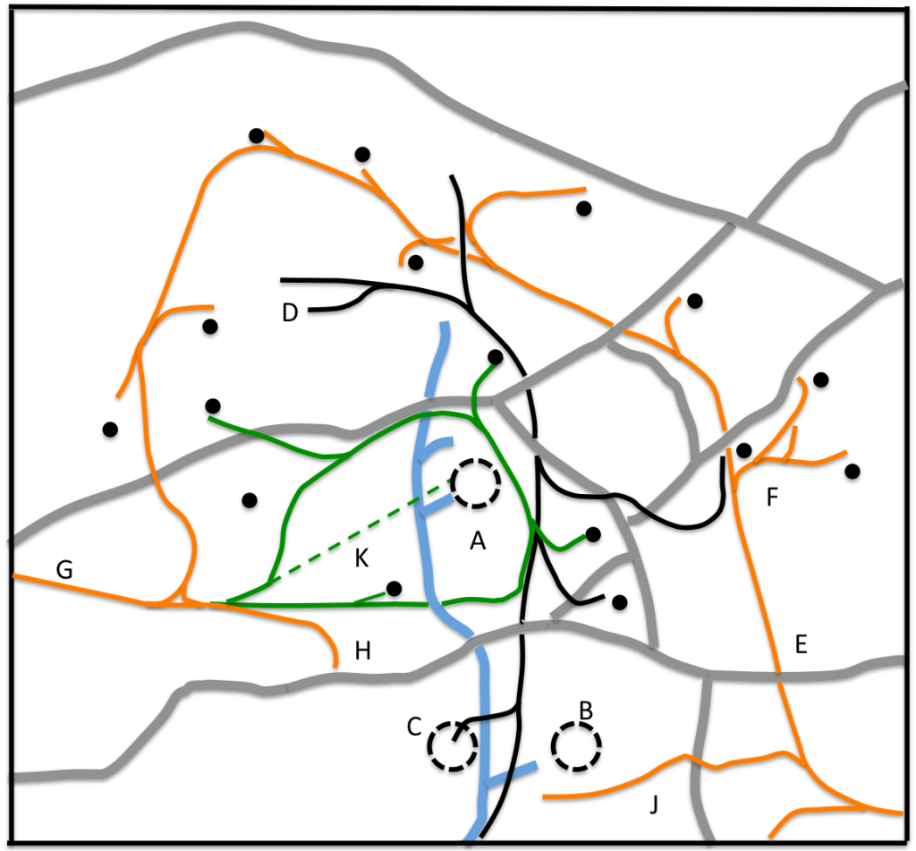
Figure 2. The railway network (GWR lines in black, Pensnett Railway in brown, Shut End Railway in green. Black dotted circles show iron works. Small black circles show coal mines in operation.)
Figure 2, to the same scale as figure 1, shows the overall railway network in 1882. The iron works at Sut End (A) and Corbyn’s Hall (B and C) are shown as dotted circles. There are three distinct railway operations. The first is the GWR line (in black) that broadly follows the line of the canal to the terminus of both near Oak Farm (D), which began life as an OWWR branch before that company was taken over by the GWR in 1863. The second is the Pensnett Railway of the Earl of Dudley (in brown), with the main line from the Wallows and Round Oak going down the Barrow Hill incline (E to F), before looping around to the north of Oak Farm to a junction with the original Kingswinford Railway (G to H). Of particular note is the long Tiled House branch (J) to Corbyn’s Hall, which will be discussed below. The third is what we will call the Shut End Railway, around the Shut End works (in green). Not all details of this railway can be shown at this scale. The dotted line indicates the course of the original incline to the works (K), which at this stage was not used. There was also a fourth system (the Corbyn’s Hall Railway), which can again not be shown at this scale. Figure 2 also shows locations of working coal pits, which can be seen in the main to be rail connected.
Now in this particular part of the Black Country, the development of Iron Works can be considered to have three phases.
- Phase 1. Where the works developed in an area where both coal and ironstone was readily available, and the first priority was to develop links to transport their products to local markets.
- Phase 2, where the immediate sources of supply were used up and a transport system to bring in coal and ironstone from the surrounding area was developed.
- Phase 3 where all the raw materials within easy reach of the works have been exploited and either material needs to be brought from a distance, the works needs to close or its nature needs to change.
In terms of these phases, Corbyn’s Hall in 1882 seems to have been in phase 3, and Shut End in phase 2. Corbyn’s Hall Iron Works was developed by the Gibbons brothers in the 1820s, and its phase 1 transport links was provided by a tramway to the Fens branch of the Stourbridge Canal to the south. This was replaced, to some extent, by the Kingswinford Railway in 1829 and by Stourbridge Extension Canal in 1840, which indeed purchased the tramway. The Kingswinford Branch of the OWWR in 1858 also gave another outlet for the products of the works. The phase 2 supply lines were also provided by a complex set of tramways on and around the estate, which can be seen on the 1832 one inch to the mile OS map and the 1840 Fowler Map. By 1882 all the local mines were exhausted and, as we shall see, raw materials were brought to the Corbyn’s Hall works from elsewhere.
Shut End Iron Works developed somewhat later that Corbyn’s Hall, in the mid-1830s, and its phase 1 transport links were immediately supplied by the Kingswinford Railway and later by Stourbridge Extension Canal and the Kingswinford Branch of the OWWR. By 1882 the map of figure 2 shows a phase 2 pattern, with its external railway network extended into surrounding areas, to mines some distance from the works. By 1903 the Iron Works had closed although some mines were still exploited, and other industrial concerns were latter to develop at the site (Phase 3).
As an aside, it is interested to note that the Round Oak Iron works of Lord Dudley can also be considered within this pattern, with the Pensnett Railway shown on figure 2 acting as the phase 2 transport links to bring in raw materials from the surrounding area from the many mines to which it was connected, although in this case this railway was also used to transport coal for export to elsewhere in the UK.

Figure 3. The Corbyn’s Hall Iron Works (GWR and Pensnett Railways are indicated by black and brown lines respectively, and the Corbyn’s Hall railway by purple lines. Old mine shafts are shown as open circles, and the major residential properties as filled triangles)
Now let us turn to the Iron works themselves. Figure3 shows the area around Corbyn’s Hall at an expanded scale. The various railways are again shown, and this time the Corbyn’s Hall Railway, an internal network within the works is also shown. It can be seen that there are two iron works. The original one was to the east of the Canal, near to Corbyn’s Hall itself, and is marked on the 1882 map as disused, but was clearly still in situ. The new works was to the west of the canal, so we probably here have a picture of the transitional situation. The map also shows the major residential properties of Corbyn’s Hall itself, by this time becoming increasingly derelict; the Tiled House and Shut End House. Many disused collieries can also be seen, from where the original raw material was obtained in the 1820s and 1830s. The Corbyn’s Hall railway itself is a complex set of interlinked lines serving the immediate needs of the old works, and providing connections to the Corbyn’s Hall branch of the Stourbridge Extension canal and the GWR Kingswinford Branch. The Tiled House branch of the Pensnett Railway (in brown) can be seen in the bottom right of the figure, ending in a set of sidings. The gradient of this branch is severe, at about 1 in 25, and there is no indication of an engine house anywhere that could provide motive power for hauling full trucks up the branch. It thus seems sensible to regard this branch as being to supply the needs of the Iron Works for coal and ironstone, rather than taking away finished products, with loaded trucks descending the branch by gravity (but with brakes!) and empty trucks being hauled up the branch by horses. It can also be seen that the Corbyn’s Hall railway provides a somewhat convoluted connection between the Pensnett Railway and the GWR in this region, although it is doubtful it was ever used such.

Figure 4. Corbyn’s Hall land use (Green indicates arable land, allotments etc. Brown indicates residential areas, including gardens, hatched area indicates spoil and waste, and grey areas active industrial areas and links)
Figure 4 shows a map of the same area as figure 3, but this time showing the land use in broad categories. Note there is some subjectivity in how these are defined from the OS map. The large area of “waste” that surrounds the works is very apparent, and was to be a lasting scar on the area for many decades afterward. Nonetheless there was still arable land in close proximity.
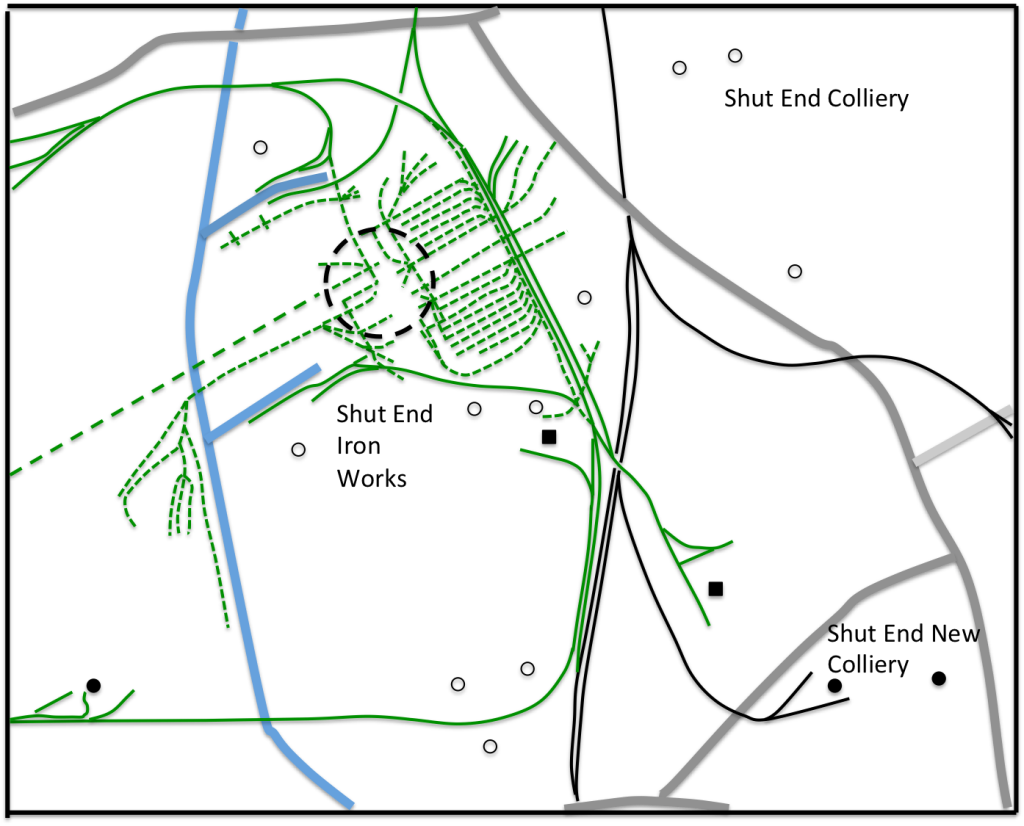
Figure 5. The Shut End Iron Works (GWR and Shut End Railways are indicated by black and green lines respectively. Working mines are shown as filled circles and old mine shafts are shown as open circles. Brickworks are shown as filled squares)
Figure 5 shows the area around the Shut End works. The most striking feature of this map is the extensive internal works network of the Shut End Railway. It would seem that this can be divided into two – the solid green lines show the tracks that connect to mines in the locality and to the Pensnett Railway and the GWR. The dotted lines show those tracks that seem to serve an internal works purpose only. Further study on the layout of the works themselves would be of interest, but I lack the detailed knowledge of the operation of iron works in that period that would be required for this.

Figure 6. Shut End land use (Green indicates arable land, allotments etc. Brown indicates residential areas, including gardens, hatched area indicates spoil and waste, and grey areas active industrial areas and links)
Finally figure 6 shows the land use in the Shut End area. Again the area of waste and spoil is significant (and indeed over the next 20 years was to come to encompass nearly all of the area shown on the map. The proximity of both arable and residential areas to the waste and industrial areas is also clear.

Another interesting article and very detailed! Incredible that such a large industrial activity took place in this area over 100 years ago and there is so little left today to give us any clues that is was ever there! Apart from the canals and a few railway cuttings and embankments, Ketley quarry is about the only thing left – but I understand there are plans to build houses there now.
LikeLike
Thanks. My interest is of course that is where I was born and brought up. When I was child (some decades ago!) there were rather more traces of theses activities, at least in the Corbyn’s Hall / Tiled House area. I really wish I had taken more notice then – and taken some photos!
LikeLike
Chris, I’ve stumbled across your website by accident but have a question you may be able to answer. The end of October my group Wednesbury paranormal are doing a ghost walk around the Fens pool area of Brierley hill, part of the walk is alongside the old round oak to baggeridge railway line. The volunteers at fens pool have been told that this area is haunted and a possible derailment took place there? Would you have any knowledge to such an event so as enabling us to pass on the story to the visitors on the night of said ghost walk. Thanks Neil mitchell.
LikeLike
See https://profchrisbaker.com/2020/05/19/the-earl-of-dudleys-railway-accidents-and-incidents/ for details of accidents between 1830 and the early 20th century. No mention of derailments in the Fens Pool area however. Bit it may help. Chris
LikeLike