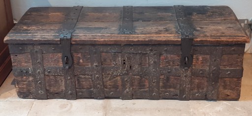
In the north transept at All Saints church in Oakham, there is a large wooden chest, shown in the photograph above. This is the Oakham Parish chest, which is encompassed by iron bands, with three locks. It is well described by a framed description close by, written by an unknown author, and dated 2007.
The earliest Parish Chests are of Norman or even Saxon date. In the early 16th century the Vicar General, Thomas Cromwell issued a mandate to the effect that every parson, vicar or curate had to enter in a book every christening, marriage and burial in his parish, with the names of the parties. In addition to these records documents relating to the day to day running of the parish would have been stored in the Chest, including the Churchwarden’s accounts, Removal and Settlement Certificates Poor Rate and Poor Law records.
The parish was to provide a `sure coffer’ with two locks, the incumbent having the custody of one key and the Churchwarden having the other. _ The safety of the documents was assured by there being two locks and therefore the opening of the Chest had to be approved by the incumbent and the Churchwarden together. The chests were usually made of oak, early ones having been `dug out’ of a substantial log. Later chests became more refined being made of boards secured with iron nails. Some were decorated with iron banding. These were common from the early part of the fourteenth century. Some had slots pierced in their lids possibly to receive monetary offerings.
An injunction in the thirteenth century was that in every church a chest should be provided fastened with THREE keys, to be kept by the Bishop, the Priest and a religious layman. It will be noted that the Parish Chest here at All Saints, Oakham has three such fastenings. Whilst an exact date cannot be made as to its origin it would appear that this Parish Chest may date from the early years of the Church.
By the mid-1500’s the parishioners in every parish of the land were instructed by law to provide a strong chest with a hole in the upper part thereof, and having three keys, for holding the alms for the poor. Another chest may have been used to keep safe the church’s plate and this or the first chest would also double up as a place where the parish registers and other parish documents could be kept safe. In some places only one chest would have sufficed for both purposes, while in other parishes two or more may have been used.
So there is a possibility that the three locks might indicate a 16th century rather than a thirteenth century date.
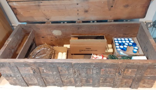
Of course, confronted by an old oak chest, the immediate question that comes to mind, is what mysteries does it still contain. The Oakham chest opens without much effort, although the lid is a bit weighty, so that question can easily be answered. And the mystery turns out to be quite mundane as can be seen from the photograph below – a crown of thorns, presumably for the Holy Week liturgy and an assortment of large and votive candles. Pretty much the sort of stuff that would be found in a cupboard in any parish church! The mysteries are long gone (and probably deposited in Leicester Archives).
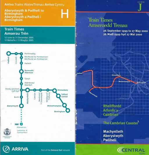
Readers of two earlier blogs will know that I have been a collector (or perhaps better described as a hoarder) of train and bus timetables for many decades. In the two posts, I used this collection to look at public transport developments in Oakham and the development of the cross city rail line in Birmingham, both over the last 50 or 60 years. In this post, I do something similar, and look at how the rail journeys through the Gwynedd town of Porthmadog have changed from the 1960s to the present day. Specifically I look at how services on the Cambrian Coast railway have changed over that period. I visited the area many times from the 1980s onwards, and particular from the mid 1990s through to the mid 2000s for family holidays. These holidays were often focussed on travelling on the Ffestiniog Railway and were thoroughly enjoyed by all. I do not however consider the services on the FR in this blog, except in passing.
In what follows, I basically consider the southbound services through Porthmadog in terms of frequency, connectivity, journey times and reliability, with my considerations based on timetables I have in my collection or are easily accessible over the web. The services heading east to Pwllheli exhibit much the same trends. But first we need to set out the basic facts about the Cambrian Coat line itself.
Cambrian Coast line
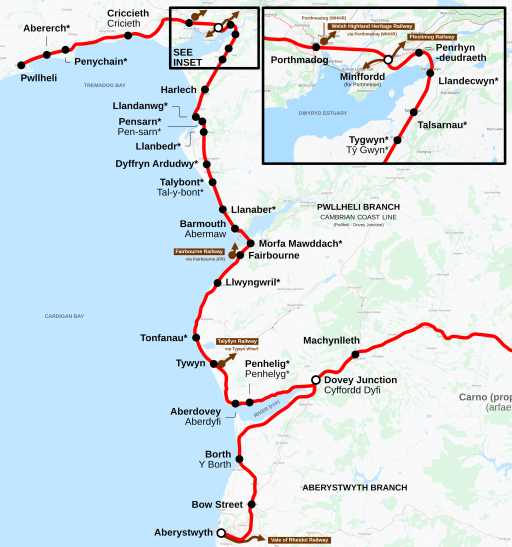
The Cambrian Coast line is shown on the map if Figure 1 (from Wikipedia). It extends from Pwllheli in the north to Dovey Junction in the south, where it meets with the Aberystwyth to Shrewsbury line. In between it passes through a number of small towns (Criccieth, Porthmadog, Harlech, Barmouth and Tywyn) and a larger number of villages. It is a single track route with a number of passing places – at Porthmadog, Harlech, Barmouth and Tywyn.
In the pre-Beeching area, there were two other connections with the national rail network – at Afon Wen between Pwllheli and Criccieth where the line was met by the Caernarfon and Bangor line; and at Morfa Mawddach, south of Barmouth, where there was a junction with the line to Dolgellau, Llangollen and Wrexham. At Porthmadog the line was crossed by the narrow gauge Ffestiniog and Welsh Highland Railways.
From the 1960s onwards the main service on the line has been between Pwllheli and Machynlleth, the latter being the first main station on the Aberystwyth to Shrewsbury line after Dovey Junction. Some of these services continued to Shrewsbury and beyond, often having attached to a service from Aberystwyth. These services have been provided by a number of operators – British Rail up to privatisation in 1996, then Regional Railways Central, which morphed into Central Trains from 1996 to 2001, then within the Wales and Border franchise operated by Arriva Trains Wales up to 2018. The franchise was then awarded to Keolis Amey Wales by Transport. Following the financial collapse of the franchise in 2021, services have been provided directly by Transport for Wales, through Transport for Wales Rail.
The traffic on the line is mostly passenger – some local traffic for work / school / leisure purposes, but mainly tourists and holidaymaker traffic that, inevitably, is much higher in the summer than in the winter. The major destinations are Barmouth, Porthmadog and Pwllheli, and up to the 1980s, there was a sizeable flow to Butlins near Pwllheli.
Post-Beeching the traction on the line was mainly coaches hauled by diesel locomotives – class 25s and then class 31s. But by the 1980s, the dominant forms of traction were DMUs of various types. Services are now provided by two coach Class 158s.
More details of the line can be found at its Wikipedia page, although this is somewhat unbalanced in subject matter and not terribly consistent in format and style.
Frequency Analysis
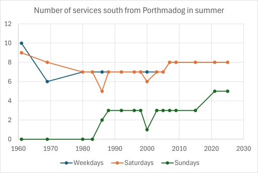
Figure 2 shows the number of trains on the line from 1960 to the present day, for weekdays, Saturdays and Sundays. These are southbound trains through Porthmadog during the summer period (there often being a slight reduction in the winter). In the early 1960s (pre-Beeching) there were nine or ten services on the line. including through trains to Wrexham (and beyond) from the junction at Morfa Mawddach. Many of the services terminated at Barmouth. There were also trains from Pwllehil to Bangor via Afon Wen that did not pass through Porthmadog. After the Beeching cuts however, the service number settled down somewhat to seven or eight per day on weekdays and Saturdays. Sunday services were introduced in the 1980s and the number of these have steadily increased to around five per day.
Figure 2. Southbound services
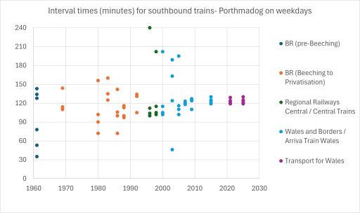
Figure 3 shows the interval between services on weekdays only – the graphs for Saturdays and Sundays tell the same story. Broadly, up to 2007, the services were irregular, with intervals between services from one hour to three hours are more. Around that time, a regular interval timetable was imposed, with trains at broadly two hourly intervals. This will be reflected in much of the discussion that follows.
Figure 3. Intervals between southbound services
Connectivity Analysis
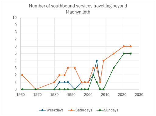
Figure 4 shows the number of through trains that ran south from Porthmadog and went beyond Machynlleth, again for weekdays, Saturdays and Sundays. From the 1960s to the 1980s these were very occasional, with most through trains running on Saturday for the holiday market. These included the Cambrian Coast Express to Euston. From the 1990s onwards the number of through services increased, mainly through the Cambrian Coast DMU coupling to the service from Aberystwyth and running to Birmingham New Street. In the late 1990s and early 2000s the turnaround time at New Street was very tight, which led to unreliability and late running, the effect of which was magnified by the single track nature of the line westwards from Shrewsbury, with delays caused by the need to wait for passing trains. This was to some extent alleviated from 2008 when most services ran through to Birmingham International. Most services on the line are now through services, although, oddly, the current timetable doesn’t acknowledge this and suggests a change at Machynlleth is necessary. There seems no obvious reason for such reticence, unless the operators are simply keeping their options open to terminate the Cambrian Coast services at Machynlleth.
Figure 4. Southbound services beyond Machynlleth
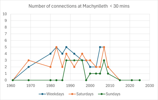
Figure 5 shows the number of connecting services from the Cambrian Coast line onto the Aberystwyth – Shrewsbury – Birmingham services, with a connection time of less than 30 mins. These peak in the 1980s and 1990s and then fall off as through trains become the norm.
Figure 5. Connections at Machynlleth
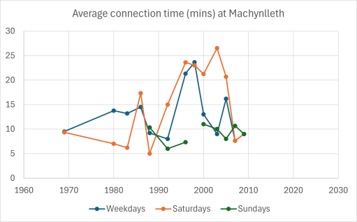
Figure 6 show the average connection times at either Machynlleth or Dovey Junction. In the 1990s and early 2000s the average connection time was over 20 minutes, with some connections (if they can be called that) having times of 40 minutes or more. Machynlleth is a very pleasant station on a dry summers day, and it is a pleasure to wait there. However, it is in mid-Wales and such days are few and far between. In general waiting there for 30 or 40 minutes for a connecting train was usually rather unpleasant. Some services required a change at Dovey Junction, a station with road access, minimal facilities and in the middle of a bog. Again on a dry summer’s day it has a certain bleak charm. But one suspects scheduling connections there was simply an act of sadism by the franchise timetabling teams.
Figure 6. Connections times at Machynlleth
Journey Time Analysis
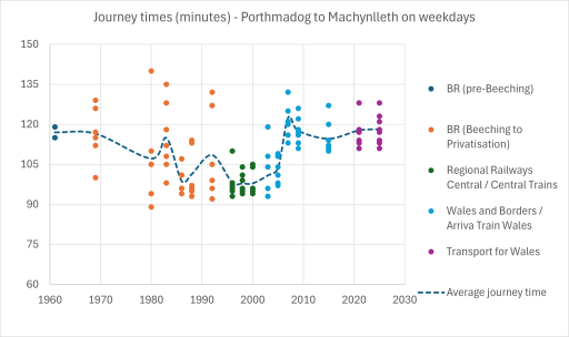
Figure 7 shows the journey times between Porthmadog and Machynlleth on weekdays – again the Saturday and Sunday times are similar. From the 1960s to the mid 1990s these decrease from around two hours on average to around one hour forty minutes on average, with a wide spread. In 2007, coinciding with the introduction of a regular interval service, there is a sharp increase in average journey times to around one hour and 55 minutes – roughly the same as in the 1960s.
Figure 7. Journey times
Reliability Analysis
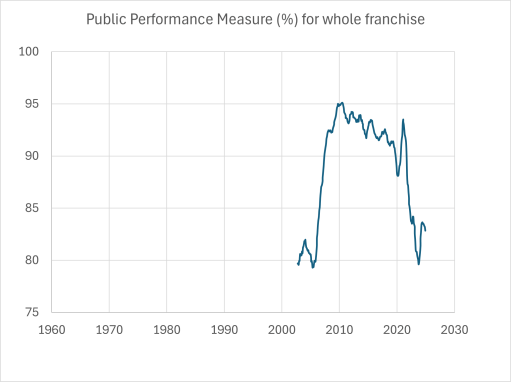
The rail industry measure reliability through the use of a Public Performance Measure (PPM). Essentially it produced a figure between 0 and 100% that is a measure of lateness / cancellation etc. All franchises are given targets for the measure that they have to meet. A value of 90 to 95% is regarded as adequate or good whilst one of 80% is regarded as poor. The historical figures for the whole of the Wales and Borders franchise are given in Figure 8. (The figures for individual routes are not easily available – at least I can’t find them on the web.) The graph shows a significant increase in PPM between 2006 and 2007, which coincides with the frequency and journey time savings on the Cambrian Coast. Now the Wikipedia page indicates that the Cambrian line was by far the worst performing line in the franchise, so it is not unreasonable to conclude that the changes made there in 2007 had a significant effect on the overall franchise PPM.
Figure 8. Public Performance Measure
Discussion
The major point to arise from the analysis presented above, is that in 2007 there was a positive decision to adopt a regular interval timetable, which enabled an increase in through journeys beyond Machynlleth through coupling with the Aberystwyth trains and resulted in a significant increase in reliability. However, this also resulted in a significant increase in journey times. The question arises as to whether a regular timetable and better connections and reliability was worth the extended journey times. I am inclined to think it was, but others may well disagree.
But could journey times be improved? I think perhaps they could be. simply having a longer layover at Pwllheli, with trains arriving there earlier and leaving later, should keep similar times for all the trains in the passing places. However I say this without having done any sort of timing analysis, which would require detailed route information and train performance characteristics. But perhaps a few minutes could be taken off the journey without loss of reliability.
Similarly, could journey frequency be improved to an hourly service? Leaving aside the issues of whether passenger numbers warrant this, or of stock availability, the answer is probably yes, if the two currently unused passing places at Barmouth and Porthmadog are brought into use. However this would effectively mean that the line was running at capacity – which would almost certainly lead to loss of reliability. A better way to improve service frequency would be, in my view, a closer integration with the Traws Cymru T2 bus service from Aberystwyth to Bangor via Machynlleth and Porthmadog. Indeed that service already offers a 1 hour 28 minute journey time between Machynlleth and Porthmadog – considerably better than the rail journey time, although it does take a much shorter route through Dolgellau.
In the writing of Kingswinford Manor and Parish (KMAP), one of the loose ends was the Brettell family, who were clearly important in the area and married into other major families, but who were very difficult to trace through the historical record, not least because they seemed to have used a very small set of Christian names, with all the confusion that implies. This issue was particularly acute when I considered the Fowler Maps of Kingswinford of 1822 and 1840. In the former we have at least one Thomas Brettell and at least one Benjamin Brettell, and in the latter we have Anna Maria Brettell and Penelope Brettell – all holding quite significant portions of land.
A reader of KMAP, Keith Evans, seeing my confusion, has come to my help. In his family tree studies he has identified the following Brettells in late 18th and early 19th century Kingswinford that are of relevance.
Benjamin Brettell (1720-1793) who married Elizabeth Jeavons in 1763, where he was identified as a Malster. He is later referred to as a Coal Master.
Benjamin Brettell (1764-1822), the eldest son of Benjamin and Elizabeth, who was apprenticed to Richard Mee of Himley in 1780 and became an attorney. Two children are mentioned in his will – Benjamin and Anna Maria.
Thomas Brettell (1769-1835), another son of Benjamin and Elizabeth, who married Penelope Antrobus Cartwright, and was recorded as a Coalmaster. Two children are again identified, Benjamin and Elizabeth.
Using the above as background information, we can consider the Brettells identified in the Directories for the Fowler maps of 1822 and 1840 in a little more detail.
Brettells on the Fowler Maps
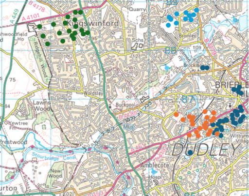
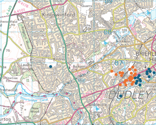
Figure 1. The Brettells on the 1822 Fowler Map – Brown circles – Thomas (Brettell Lane); Dark blue circles – Benjamin; Green circles – Thomas (Summerhill); Light blue circles – Thomas (Tiled House)
In 1822, there were four clusters of land that were either owned or occupied by a Brettell (Figure 1, which shows those plots of land owned or occupied by Brettells, superimposed on a modern map).
Those lands owned by Benjamin Brettell at the upper end of Brettell Lane and in Brierley Hill and Brockmoor. These were, as far as can be judged, in the area that was enclosed by the Pensnett Chase Enclosure Act of 1784 and allocated to Benjamin Brettell Senior.
Those lands owned by Thomas Brettell along Brettell Lane. These adjoin those of Benjamin, but are on land that was not enclosed in 1784 i.e. land that was either an old enclosure or a more formal old estate.
Those lands owned by Thomas Brettell in Summerhill, including Summerhill house where he resided. These were in the area where the 1776 Ashwood Hey Enclosure Act formalised informal enclosures of 1684, so this block of land probably originates in this period.
The Tiled House Estate occupied and inhabited by Thomas Brettell, but owned by Richard Mee (the son of the Richard Mee to whom Benjamin junior was apprenticed).
The blocks of land in the Brettell Lane area were not continuous, and werei nterspersed with lands owned by others.
The immediate question is whether or not all these lands were owned by the same Thomas Brettell. The Thomas Brettell at Summerhill is sometimes styled in the Directory of the 1822 Fowler Map as “Esq.” which may differentiate him from the other Thomas’s. Against that is the fact that some of the land was occupied by Benjamin Brettell, either Thomas’s brother or his son. It is of course possible there might have been another Benjamin, but this does tend to suggest that the same Thomas owned lands in Brettell Lane and in Summerhill. If that is the case, then this Thomas would have no need of the Tiled House as a place to live in and one must conclude that the Thomas who lived there was not the same Thomas who held lands in Brettell Lane and Summerhill. All very confusing.
The other point that can be made is that the fact that Thomas and Benjamin’s lands along Brettell Lane adjoin each other suggest that in the previous generation (i.e. Benjamin Senior) they were one land unit.
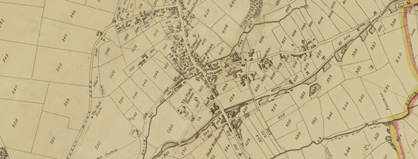
Figure 2. The Brettells on the 1840 Fowler Map – Brown circles – Penelope; Dark blue circles – Anna Maria
In 1840, it is clear from Figure 2 that all Benjamin’s lands went to Anna Maria and all of Thomas’s Brettell Lane lands went to Penelope. Thus one must conclude (along with Keith Evans) that Anna Maria was Benjamin’s daughter and Penelope was Thomas’ widow. At that time the Summerhill estate was in the hands of Revd. Henry Hill, a cleric from Worcestershire. He rented these out to be farmed, mainly by the large farming firm of John Parrish and Co.
A ghost from the past
The name Brettell seems to originate from Bredhull, or broad hill, in the early middle ages. This seems to have been centred on Hawbush along Brettell Lane, a little to the south west of the land holdings of Thomas were in 1822 (Figure 1). Is it too fanciful to speculate that what we have here is a ghost of an old estate, with much of the land sold to others? We know that such estates existied in the north of Kingswinford parish – Oak Farm, Shut End, Corbyn’s Hall, Tiled House and Bromley House) and perhaps here we have a southern counterpart. It would be unwise to take this speculation much further, ut it is, perhaps, and intriging possibility.
In a post from 2021, I write about some of the more unusual landowners in Kingswinford parish in the first half of the 19th century. This was based on material in my ebook Kingswinford Manor and Parish. One of those I discussed was Jonathan Stokes, the son of Rebecca and Jonathan Stokes, “Gentleman of Worcester”. He was a member of the Lunar Society, who is remembered for his work on the use of digitalis in medicine. He practiced as a doctor in Stourbridge from 1882 to 1885. The Directory for the 1822 Fowler Map of Kingswinford parish shows that at that time he had extensive agricultural land holdings in the Wordsley area, which, by the time of the Tithe Apportionment in 1840 were held by his son John Allen Stokes. At the time I did not know how these lands came into his possession. My only clue was that in 1788, Rebecca Stokes, at that point a widow, was involved in the sale of a plot of land on which the Red House Glassworks in Wordsley was built, and may well have had other land in the area at the time. In the earlier post, I made the following conjecture as to how these lands came into the Stokes’ possession .
One possible route comes from a recorded marriage in 1781 between Nancy Freeman, one of the illegitimate children of John Keeling, the agent and steward of the Dudley estate who owned significant property in the area, and one William Stokes. Links with either Jonathan however cannot be demonstrated, so this must be conjectural. Keeling did however provide generously for his illegitimate offspring, and this might be another example of his provision.
The William Stokes in question however was a “Gentlemen of Wolverhampton” (yes, such did exist!) and no connection with Jonathan’s family could be found.
In this conjecture however, I was absolutely and completely wrong. I would like to say that I discovered the reality of the situation by painstaking archival study, but in fact it was by pure chance. I have recently been helping to set up the Black Country Society Shop web page, and was browsing through one of the books that is for sale – Artists in Cameo Glass by H. Jack Haden from 1993. There I read the following.
The site of the Red House Glassworks was bought on 21 June 1788 by the Wordsley glass manufacturer Richard Bradley from John Southwell, master at Stafford Grammar School, and his wife Ann, and Rebecca, widow of a Worcester glover Jonathan Stokes, Ann and Rebecca being the daughters of Rebecca Allen who was the daughter and heir of John Dancer of Wordsley. Jonathan and Rebecca Stokes were the parents of Jonathan Stokes, M.D., who practiced as a physician in Shrewsbury, Kidderminster Stourbridge and finally Chesterfield. He was also well known as a botanist and a member of the Lunar Society, so well-known to James Keir (1735-1820), the distinguished industrial chemist who resided at Holloway End House, Amblecote, in the mid-1770s and was a partner in the Holloway End Glassworks.
So the Wordsley lands came through the maternal line of Rebecca Allen, rather than the paternal line as I had assumed in my searches. A kick in the teeth for my patriarchal attitudes. Further I should have spotted the clue to the maternal line in the unusual spelling of Jonathan Stokes son’s middle name of Allen. All very humbling, but good for the soul no doubt.
Within a few minutes of reading “Artists in Cameo Glass” I received an email out of the blue that gave me details of another family that appears in Kingswinford Manor and Parish about whom I could find out very little – Thomas and Benjamin Brettell. The Brettells will be the subject of a future blog post.
I have been a collector of old bus and railway timetables for many years, with no particular end in view, other than to put them in boxes for some unspecified future use. However, the assembled timetables seem to be too good a resource not to make use of in some way, and I used some of them to compile a recent post on the development of public transport in Oakham in Rutland. This went down surprisingly well with readers, which shows there are some very odd folk out there. But the reception has encouraged me to press ahead with a series of posts that will use my stash of timetables to look at the development of public transport services in particular places or on particular routes. This particular post will consider the development of the Cross City railway line that runs from Lichfield in the north, through Birmingham, to Redditch and Bromsgrove in the south. There is an excellent Wikipedia article that describes the history of the line, and there is little point in reproducing that, and in this post I will concentrate on the development of the timetable on the line from the early 1960s (when it didn’t exist as one route) through to the present. It will be seen that it is in some sense a story of ambition that has never been quite fulfilled because of operational issues.
In what follows we will track this timetable development through the use of timetable extracts – usually for the weekday morning post peak period, but sometimes for other parts of the day where the (lack of) availability of information makes that necessary. This shows the broad outline of the timetable, but cannot of course capture the full detail.
September 1962 to June 1963
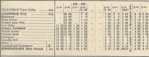
North
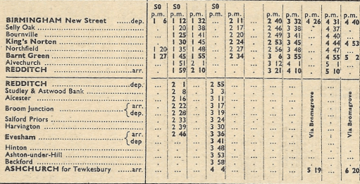
South
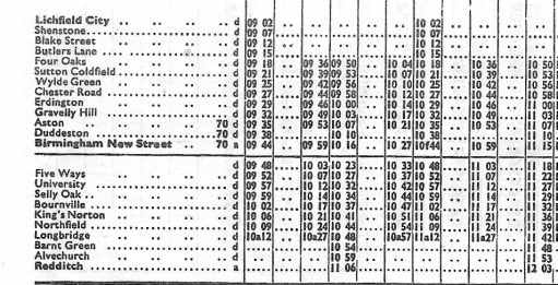
We first of all consider the situation in the early 1960s. Extracts from the timetables for the routes that were ultimately to form part of the Cross City line are shown above, for the early afternoon weekday period (taken from the London Midland Region timetable for September 1962). It can be seen that there is broadly a half hourly service from Lichfield city to Birmingham New Street. Connections are provided to Lichfield Trent Valley (where the current Cross city line crosses the West Coast Main Line) by a Burton on Trent – Lichfield – Walsall service, with occasional through services from Trent Valley to Birmingham. Some trains started and terminated at Four Oaks, but there was no regular pattern. South of New Street, the service to Redditch was somewhat sporadic, with some trains extending to Evesham and Ashchurch for Tewksbury. Note that trains did not at that stage call at Five Ways (which was closed) or University (which didn’t exist).
September 1964 to June 1965
North
South
By 1964, the first wave of the Beeching cuts had taken place and the timetables above (again from the London Midland Region timetable) such trains as there were to Redditch from New Street terminated there. North of New Street, the service to Lichfield varied between a thirty minute and an hourly frequency, with hourly trains starting at Four Oaks. Again, there were connections to Lichfield Trent Valley from Lichfield City on the Walsall to Burton service.
May 1969 to May 1970
North
South
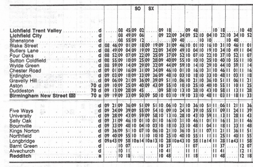
The May 1969 timetable (from the London Midland Region timetable downloaded from Timetable World) shows a more regular service on the north end of the route, with an hourly service from Lichfield City and a thirty minute service from Four Oaks to New Street. South of New Street the trains to Redditch were again somewhat sporadic, with one, two or three hour intervals between them.
May 1978
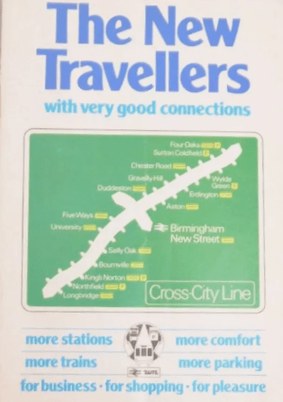
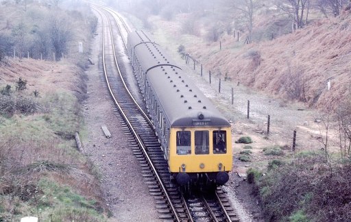
The Cross City line opened in something like its current form in 1978. The graphic above (a screenshot from a rather fuzzy ebay photo) shows that it was marketed as a service between Longbridge and Four Oaks, with a fifteen minute interval service between the stations. There were in fact hourly trains to Lichfield City that were not referred to in the timetable shown, and sporadic trains to Redditch in the south. The route was operated at this stage by Class 116 DMUs. Five Ways station had been re-opened and a new station built at University.
Class 116 DMU
May 1980 to May 1981
The May 1980 service (shown above from the national BR timetable) is similar to the 1978 service. Here the extract shows no services to Redditch although there were again some sporadic, mainly peak hour services down the Redditch branch.
May 1983 to May 1984
By May 1983 the situation to the south had become more satisfactory with hourly trains to Redditch, with Lichfield City also having hourly trains, and four an hour from Four Oaks to Longbridge.
May 1984 to May 1985
One year further on, in May 1984, the situation is again similar, but with one of the Four Oaks trains per hour extended to and from Blake street.
July to September 1991
By 1991 there were significant changes. Two trains per hour ran south from Lichfield Trent Valley (which had been reopened in 1988), four trains per hour from Lichfield City with some peak services running from Blake Street.. To the south there were four trains per hour to Longbridge, two of which were extended to Redditch.
September to November 1992
The BR national timetable showed that the situation in September 1992 was very similar to the previous year, but was only timetable to extend to the end of November 1992, when a different timetable came into operation (see below).
December 1992 to May 1993
The December to May 1993 timetable is very odd, with the services being split at New Street, with four trains per hour from Lichfield Trent Valley to Birmingham, and four to Longbridge, with two extended to Redditch. There is no rationale given for this but may well have been something to do with the electrification works that were going on at the time.
June to September 1997
My more intimate involvement with the Cross city line began in 1997/8 when I began working at the University of Birmingham, whilst living in Lichfield, and travelling on the line daily. I thus began collecting the Cross City pocket timetables at this point. It will be seen below that the art work / size / format changed continually over the years that were to follow. The route had been electrified in 1993 and was thereafter, until 2024 operated by Class 323 EMUs, up until 2020 in mainly three car formation, with some six car trains at peak times. The situation was similar to the early 1990s with four train per hour frequency between Lichfield City and Longbridge , with two trains per hour extended to both Redditch and Lichfield Trent Valley.
Class 323 EMU
June to September 2002
In the summer of 2002 we have a very similar looking timetable and frequency, albeit with some slight changes of times. But in general we can see the timetable pattern has remained stable over at least five years.
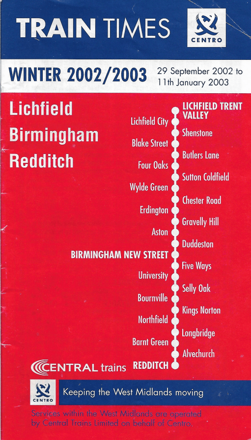
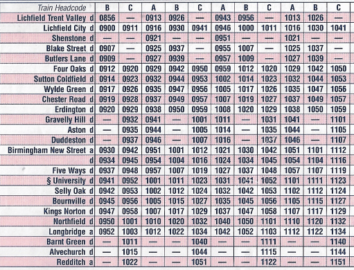
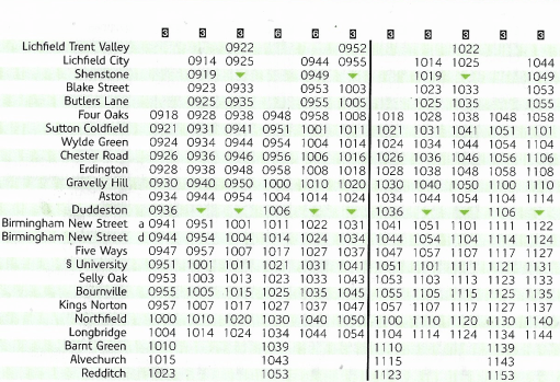
September 2002 to January 2003
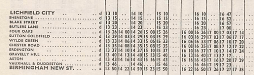
In September 2002, there was something of a revolution. The number of trains was increased to six per hour, with four beginning their journeys at Lichfield Trent Valley, and two at Lichfield City and four ending their journeys at Longbridge and two at Redditch. The stopping pattern was complex with not all trains stopping at all stations. To try to make life easier for passengers, trains were to carry a headcode (that can be seen on the above timetable) indicating their destination and the stopping pattern. To put it bluntly, the service was an absolute disaster. A very frequent service with variable stops needs to be highly reliable – and that has never been the case for the Cross City line, largely due to congestion at New Street. My memory is of confused and angry passengers, very late running and many cancelled trains. Although the ambition was laudable, the pattern was never going to work. My memory is that it was replace by an emergency timetable within only a few weeks of its implementation, but I can’t be certain about that. At any rate, a new timetable was issued from January 2003.
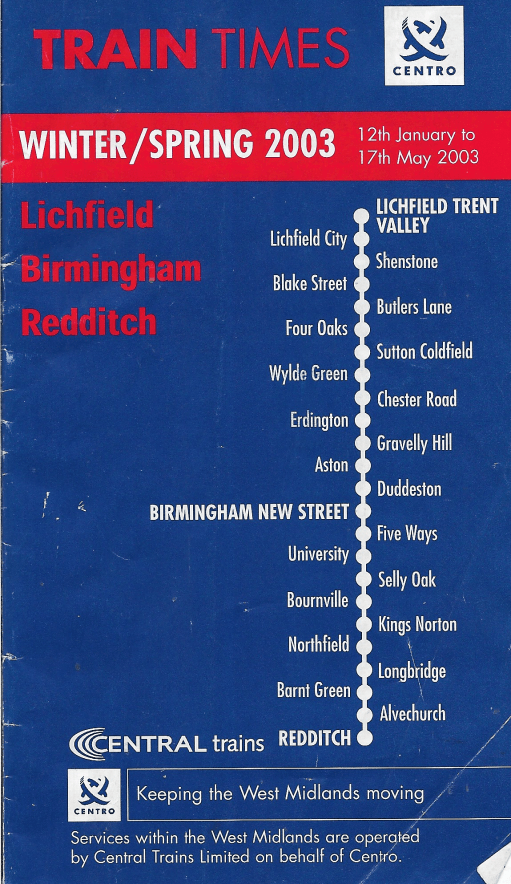
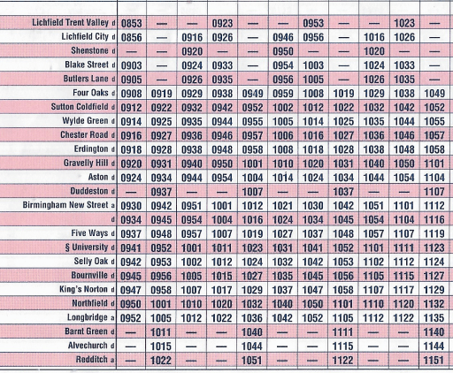
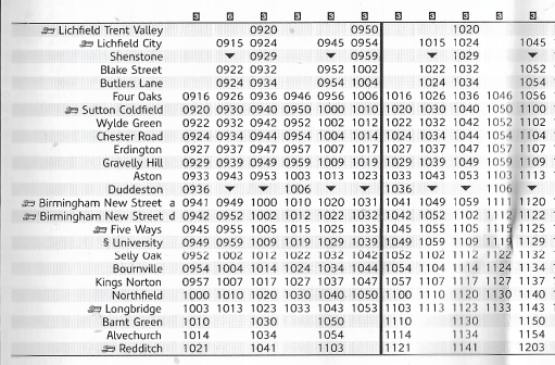
January to May 2003
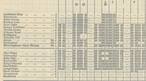
The new timetable again had six trains an hour, two beginning at Trent Valley, two at Lichfield City and two at Four Oaks, with four an hour terminating at Longbridge and two at Redditch. With only minor exceptions (Shenstone and Duddeston), all trains stopped at all stations. From a personal perspective, this led to an unbalanced departure schedule at Lichfield City, with twenty and ten minute intervals, but this pattern was to persist, in essentially the same form until 2018.
May to December 2009
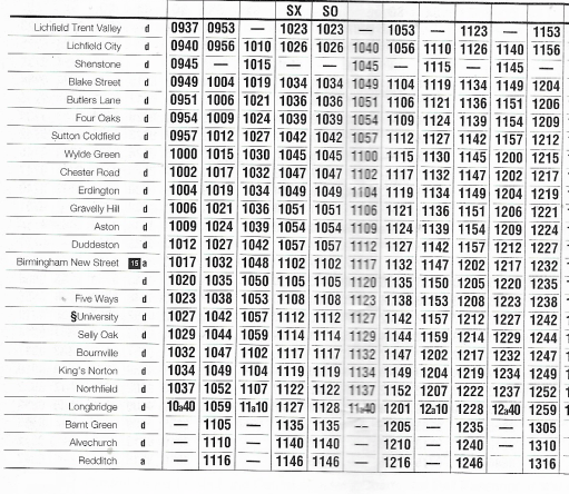
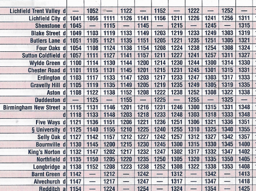
The 2009 timetable is very similar to that from 2003, with very minor changes of timing.
May 2015
Similarly the 2015 timetable was of the same form, but Redditch was now served by three trains per hour following the opening of a passing loop at Alvechurch that increased the capacity of the branch.
May to December 2019
The main change in 2019 was the extension of two of the three services that terminated at Longbridge to Bromsgrove, following electrification of the line through Barnt Green, with some other slight timing modifications. Then in 2020 COVID happened.
May to December 2022
During the COVID lockdown, the services on the cross city line were scaled back to four per hour, with two starting at Lichfield Trent Valley and two at Four Oaks, with two terminating at Bromsgrove and two at Redditch and this pattern was to persist. These four trains used four of the six paths from the earlier six train timetable resulting in unbalanced intervals between trains along the line. Stations north of Four Oaks suffered particularly, with the service being reduced to half hourly, the lowest level of service since the mid-1980s. To make up for this all services were six coaches however.
December 2024 to May 2025
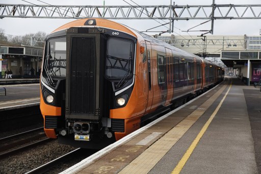
In the present 2024 winter timetable, this situation persists, for good or ill. The quality of the rolling stock has however increased with the use of Class 730 EMUs.
Class 730 EMU
Journey times and leaf fall timetables
Finally, before I close, I will brielfy discuss journey times and leaf fall timetables, which are quite closely connected. I take the journey time between Lichfield City and Birmingham New Street as a comparative value through the years. In the 1960s, when the service was operated by Class 116 DMUs, the journey time was around 45 minutes, but by the close of the decade it had reduced somewhat to between 40 and 42 minutes. . After electrification with the introduction of Class 323 EMUs , this time fell to between 35 and 37 minutes. Current times with the Class 730 are still around 37 minutes.
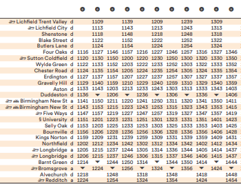
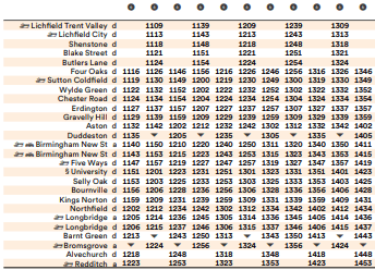
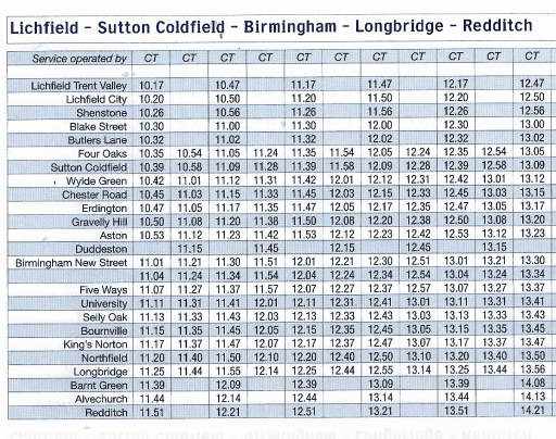
From the early 2000s a “leaf fall timetable” has operated on the Cross City line between October and December, when track conditions can become difficult. A typical example for 2005 is shown below. At the time the normal timetable consisted of six trains an hour, with two starting at Lichfield Trent Valley, two at Lichfield City and two at Four Oaks, with four terminating at Longbridge and two at Redditch. The revised timetable shows four trains an hour, with two starting at Lichfield Trent Valley and two at Four Oaks, with two terminating at Longbridge and two at Redditch. Journey times from Lichfield City to Birmingham New Street were 45 minutes. There was thus both a significant reduction in service frequency and a significant increase in journey time in the interests of maintaining reliability.
Closing remarks
As I said at the start of this blog, the history of services on the Cross City line show a commendable ambition on behalf of the operators, but with this ambition compromised by lack of operational reliability. The six train per hour service that operated from 2003 was notoriously unreliable, with this unreliability in the peak leading to significant overcrowding as two trains worth of passengers often tried to squeeze onto one, with most trains having only three coaches. Perhaps the current less frequent timetable, but with longer trains, is more satisfactory in that regard. The unbalanced timetable, with alternating ten and twenty minute gaps between trains is far from satisfactory however. If one is optimistic, one might say that this will allow six trains per hour to be reinstated in the future, but if this is not going to be the case, the timetable really does need recasting with a consistent fifteen minute interval.
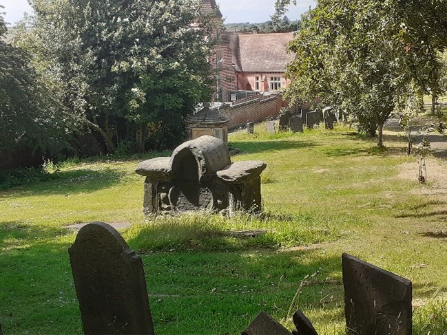
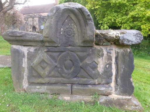
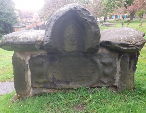
In 2021 I discussed some of the early graves in St. Michael’s churchyard in Lichfield. Amongst these was the distinctive “saddleback grave” shown in Figure 1 below, one of the five listed monuments in the churchyard. At the time I wrote as follows.
The inscription is very worn and the dedication of the monument can’t be read. This grave features in a nineteenth century drawing that is in the William Salt library ……. That drawing gives the date of the grave as 1674, and with a little imagination this can be made out on the tomb itself. Apart from the date, it is the style of the grave that makes it so distinctive. It is a shame that the dedication is illegible.
Figure 1 The Saddleback grave in 2021
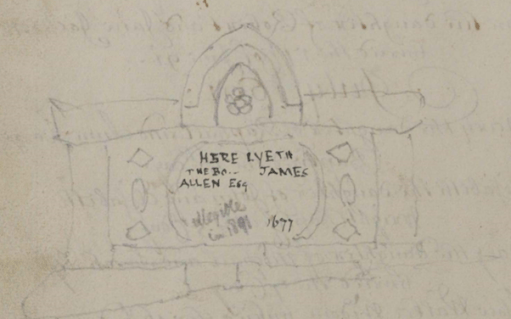
And this is where serendipity comes in. Over the last few days I have begun to think about filling in some of the gaps in my long term project to collate the memorial inscriptions of St. Michael’s churchyard with the burial registers – specifically to include material from the early registers up to 1812. A very helpful archivist at Staffordshire Archives told me that these have been scanned and can be found on Find my past. So I have been busy doing some mass downloads of the material during my seven day free trial (as you do). Whilst doing this I came across the sketch shown in Figure 2 in the register from 1680-1741, on a blank page opposite the entries from November to March 1691 (note this was before the calendar change!)
Figure 2. The sketch from the 1680 to 1741 Register
It clearly shows the Saddleback grave and gives the inscription as
Here lyeth the bo… of James Allen Esq…..1677
There is another note in lighter script that says
Illegible in 1891
So it seems we have an identification of the occupant of the Saddleback grave – although the date is given as three years later than indicated on the William Salt picture. Checking back on the records however in the 1574 to 1680 register, the only entry that corresponds to the name is from 1674
April 13th Mr James Allen, Magistrate, Beacon St
Beacon St is somewhat conjectural however – it is not easy to read. So it looks as if the William Salt date is the correct one.
The registers tell us little else. There is an entry for the marriage of James Allen (Gent) to Mrs. Hester, daughter of Richard Pyot (Dyot?) in November 1658 at St. Mary’s which seems possible. However this was in the Civil War / Commonwealth period when records become very patchy, so there may have been other about with the same name. If any reader knows more of James Allen, then please let me know. But a least we now have a name.
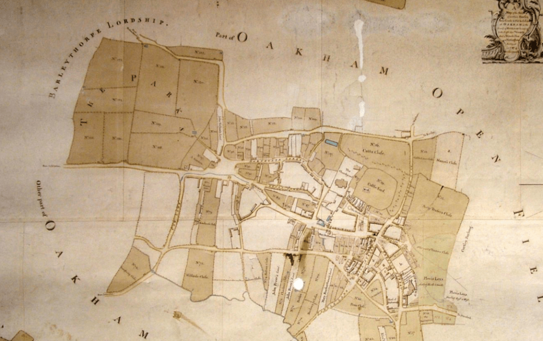
In the monograph “Oakham Lordshold in 1787”, Clough (2016) considers the map of the town of Oakham in Rutland produced for Lord Winchilsea in that year. This is the earliest map to show significant detail of the urban topography of the town, and from it Clough was able to infer some aspects of its late Anglo-Saxon / early Norman topography, in particular the existence of two enclosures encompassing the castle and the church, and the castle and a large portion of the town. In this post. I take his considerations somewhat further and, by considering the likely Anglo-Saxon road network around Oakham, infer some further features of the Anglo-Saxon urban topography.
Oakham connections
Cox (1994) in his extensive survey of Rutland place names, identifies a number of settlements in the Oakham area that were likely to have been in existence in the sixth and seventh centuries i.e. early on the Anglo Saxon era. These are as follows.
Place names ending in -ham, meaning village or estate. These include Oakham itself; Langham and Wymondham to the north west; Greetham and Grantham to the north east, Empingham to the east and Uppingham to the south.
Place names ending in -dun meaning a large hill, of which the only one in the vicinity of Oakham is Hambleton.
Place names associated with the Anglian tribe of the Hwicce of which Whissendine to the north of Oakham is the only one locally.
The villages of Brooke, which has an early attestation, and Braunston, which incorporates an early form of Anglo-Saxon name and has possible Roman antecedents.
The -well names meaning spring, and in particular Ashwell, although this might be slightly later than the others.
The major settlements in the wider region either with proven continuity since the Roman period or are of an early form- Leicester, Nottingham, Lincoln and Stamford.
In what follows we presume that in the Anglo-Saxon and Norman periods, Oakham had road / pathway connections to these early settlements that are, broadly, the predecessors of those we see today at least out of the settlements themselves. Country roads are very conservative topographical features and change little over the centuries. Within, and on the entry to settlements, they would however have been more prone to change, because of building and commercial developments. In these terms we will consider seven such roads that converge on Oakham and in particular we attempt to trace the “natural” course of these roads into and through the town, again assuming that these are the courses that would have been followed in the Anglo-Saxon period, rather than the courses that have developed over the centuries.
But first a broader point is worth making. Oakham was in the ninth and tenth centuries was in many ways at the centre of the Danelaw, with roads passing through it that connected Leicester in the west to Stamford and Lincoln in the east, and Northampton in the south with Derby and Nottingham in the north. As such, it is likely to have been of some strategic importance, particularly during the period when King Edward and Lady Aethelflead finally defeated the Danish armies in the area between 910 and 920.
The Anglo-Saxon roads
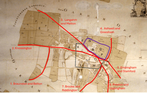
The roads that we are considering are shown in Figure 1 on a copy of the 1787 map as given in Clough (2016). These are as follows.
Figure 1. The proposed early road layout
Road 1 from Belton and Braunston (and beyond that Leicester) that runs up what is now Braunston Road and West Road (formerly known as Cow Lane) and joins Road 2 to the west of Oakham.
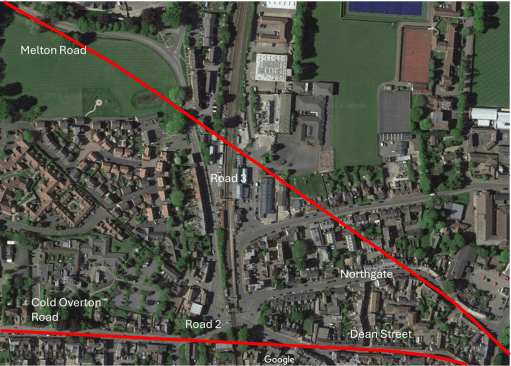
Road 2, the current Cold Overton Rd from Knossington, runs in a west to east direction, across what would become many centuries later the railway crossing and into Oakham. If the line of the road is continued, it runs along Dean Street (A) towards the church (B), and not along High Street. This straight alignment is very clear from the satellite view of figure 2. I will argue below that High Street was a relatively late development and was laid out in the Norman period. I have then shown the road running to a point in the current market place (C) in front of the castle (D) although this last stretch is conjectural.
Road 3 is the road from Melton Mowbray (and Derby and Nottingham beyond) through Wymondham and Langham. The modern approach to Oakham is via a sharp 90 degree turn along the railway down towards the level crossing. It will be seen below that this route was actually in place in the 16th century at the latest, so it is not a modern development. However, here we take the natural line of the road to continue from the north of the area marked as the Parks (E) towards the sharp kink in the modern Northgate (F) and then following Northgate and Church Alley to a junction with Road 2 in the Market Place. Again, this natural course is very obvious on the satellite view of Figure 2. This seems a much more natural route into the centre of the town.
Road 4 is from Ashwell and Greesham (and beyond that Grantham) that is taken to follow the existing course of Burley Rd. east of the castle to a junction with Road 5.
The course of Road 5 from Stamford and Empingham has changed significantly over the centuries, as it was moved to loop around Catmose Hall. Clough conjectures that it used to entire town through either or both of Bull Lane (G) or Tanners Lane (H) to the north of Bull St. We choose the latter course here as it allows this road to meet those from the west in the Market Place.
Road 6 from Uppingham and Preston follows its modern course to the end of Mill St. (J) and then cuts across to meet the other roads in the Market Place,
Road 7 from Brooke and Riddlington follows the current course of Mill St. to a junction with Road 6 (J).
Figure 2. Satellite views of the western and northern approaches
The Saxon / early Norman enclosures.
Figure 1 also shows two enclosures. The black dotted lines is a (very) conjectural boundary of the Anglo-Saxon settlement, based on the discovery of boundary ditches at K, L and M summarised by Clough. The purple solid line is the enclosure surrounding the castle and the church identified by Clough, largely on the basis of the flooded ditch at N (that has also been identified in archaeological investigations). Taken together these two enclosures would seem to represent the extent of the Anglo—Saxon and early Norman settlement. The strategic and defensive position of the castle (and in particular the Motte in the south east corner P) adjacent to the meeting point of the roads through the town is very clear. The most striking point about the proposed reconstruction is the absence of the High Street – its anomalous orientation with regard to the other roads suggests it postdated the original road layout. South Street was however likely to be in existence early as it marks the southern boundary of the enclosure. Note its original course ran straight from the west to the east, and did not diverge to the south east at its eastern end.
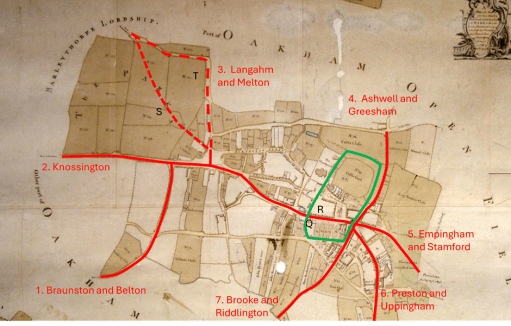
Changes in the Norman period
Figure 3. The post-conquest road layout
Figure 3 shows the road system and enclosures in the later Norman period. Clough identified the enclosure outlined in green that contains the castle and the portion of the town to the south. He speculates that the pattern of enclosures was changed when the manor was relinquished by (probably) William II and divided between Lordshold and Deanshold (the Dean referring to being that of Westminster Abbey), with the results that the church and the castle holdings were separated. This enclosure was again identified on the basis of a flooded ditch at Q. Clearly the function of this enclosure is very different and seems to be about controlling the movement of people and goods through the town (presumably for taxation purposes). It is like that this is the period when the current High Street came into existence. The Speed map of 1611 (Figure 4) shows “Bargate” at R, (built into the current Flores House) where presumably people and goods were assessed . The road system has also been changed to ensure all traffic flows along High Street. In the west, Road 3 was rerouted, probably in the first instance to follow the current line of Park Lane (S) down to Road 2. At some point the area named as the Parks was enclosed (both routes are shown on the 1611 map), and the route would again have been changed to run around this area, resulting in the modern road configuration (T). The current traffic chaos around the level crossing on the Cold Overton Road thus has its genesis many centuries ago! The combined roads 2 and 3 were then rerouted along the new High Street, rather than down Dean Street. To the east, it is likely that the Stamford Road was rerouted to come into town via what is now Bull Lane.
Figure 4. The Speed map of 1611
Loose ends
In this final section we note a number of what might be called loose ends in the above argument – the lack of destinations for one of the identified roads; the lack of direct roads from a significant place in the locality and the nature of the town “gates”.
A road to nowhere
Road 2 approaches Oakham on a straight route from the west, and within the town becomes Dean Street. But where was it coming from? There are no settlements out in that direction that can be confidently given an early date. Two thoughts come to mind – either that it was part of a somewhat roundabout route to Leicester, or that it was the route to what can be surmised to be early fortifications of the Rutland border to the west (where a number of names indicate beacons). There are no doubt other possibilities.
The route to Hambleton
There are clear indications in Domesday that the major settlement in the area at the time was Hambleton, and it was suggested above that this settlement was of an early date. As far as can be ascertained from the fairly recent maps that are available, the route there was a 90 degree junction of the Stamford Road (see the 1900 Ordnance Survey map of Figure 5). However the map shows a pedestrian way to the west of the junction that cuts of a corner and is a much more natural way to Hambleton. It seems possible that the Stamford Road bifurcated at that point with branches to Empingham and Stamford to the north and Hambleton and Ketton to the south, but that this junction was supressed during the enclosures. So Road 5 might better be referred to as the road to Hambleton, Empingham and Stamford
Figure 5. The road to Hambleton (from 1900 Ordnance Survey map
The gates
“Gates” is an ambiguous word. It can either refer to a physical gate to the town, or be a derivation from the Norse -gata simply meaning road. Bearing this in mind, Clough identifies two gates – an East gate at the entry of the Stamford Road into the enclosure around the present Bull Lane, and a West gate – the Bar-gate mentioned above. The road system was clearly arranged to direct all traffic through these, and resulted in quite a small central enclosure.
Now, whilst no south gate has ever been identified, from the earliest maps, there is a Gibbet Gate shown on the Speed Map on Stamford Road (Figure 4). This is someway outside the enclosed areas, and is this case the word gate probably simply defines a road rather than anything else. albeit one leading to a somewhat grisly destination.
The name Northgate, however, appears on a number of maps. On the Speed map this is positioned somewhere near the railway crossing, and on later maps, the current Northgate is known by either that name or by Northgate Street. Again, this could either refer to an actual gate to the town, or simply a way to denote a road. But if there was an actual North Gate, where was it? In my view, the most likely position is at the current sharp junction of the modern Northgate – F in figure 1, on the original Melton Road and at the possible confluence of the Saxon town and Castle / Church enclosures. A modern photograph is shown in Figure 6 below – taken from the east showing the possible location of the north gate (the thatched cottages) and the line of the road from there to the castle.
Figure 6. The possible location of the north gate
References
Clough T. H. McK. (2016) ” Oakham Lordshold in 1787 – A map and survey of Lord Winchilsea’s Oakham estate” Rutland Local History & Record Society, Occasional Publication No 12
Cox B (1994) “The place-names of Rutland” English Place Name Society
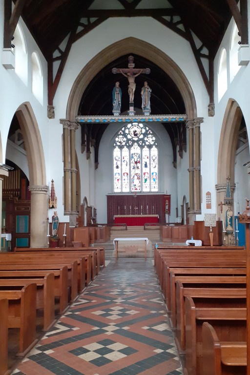
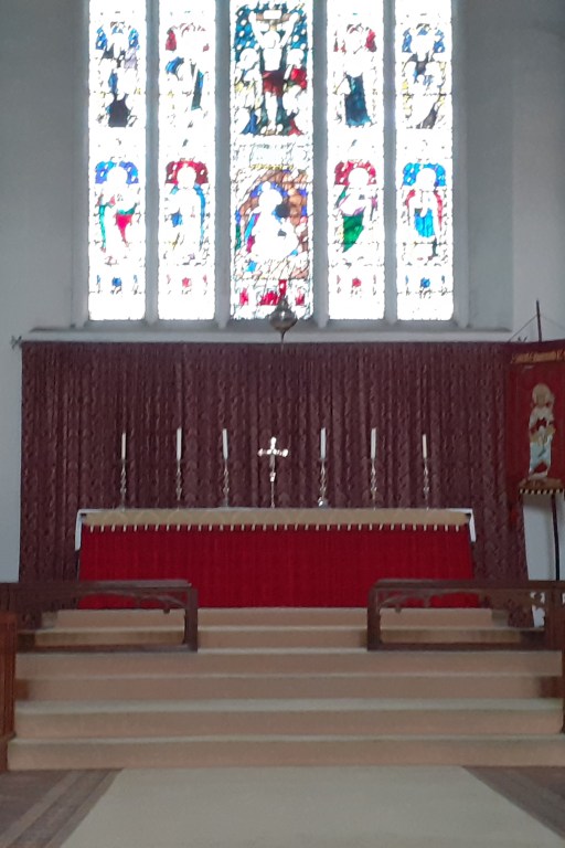
Appropriately, on the eve of St Edmunds Day in November 2024, we paid a visit to St Edmund’s church in Hunstanton in Norfolk (“we” being myself, my wife and our dog).This mid-Victorian church is VERY Anglo-Catholic as can be gathered from the photographs of Figure 1 which show the crucifix in the chancel arch, the baptistry at the west end (with the chapel of Our Lady at Walshingham on the right), and the raised altar in the chancel. I doubt I could ever have managed to get up and down those altar steps safely in a cassock or alb, and certainly now, if I were ever to preside there (which is unlikely in the extreme), I would certainly need a stair rail, and possibly, given the current state of my right knee, a stair lift*. That being said, it is an impressive church interior.
Nave and chancel (east end)Baptistry (west end)Altar
Figure 1. The interior of St. Edmund’s
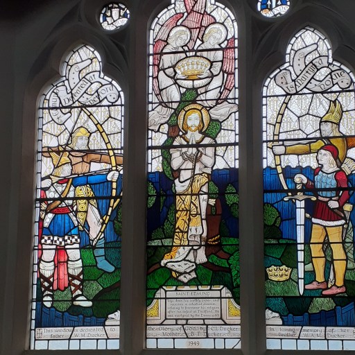
Now whilst there are some fairly conventional depictions of biblical events and saints in the windows in the church, those that I found of most interest are the series of windows that depict the life and death (and afterlife) of King Edmund. In reality, very little is known about him other than the entry in the Anglo Saxon Chronicle of 870.
In this year the raiding army rode across Mercia into East Anglia and took up winter quarters at Thetford. That winter King Edmund fought against them, and the Danes had the victory and killed the king and conquered all the land.
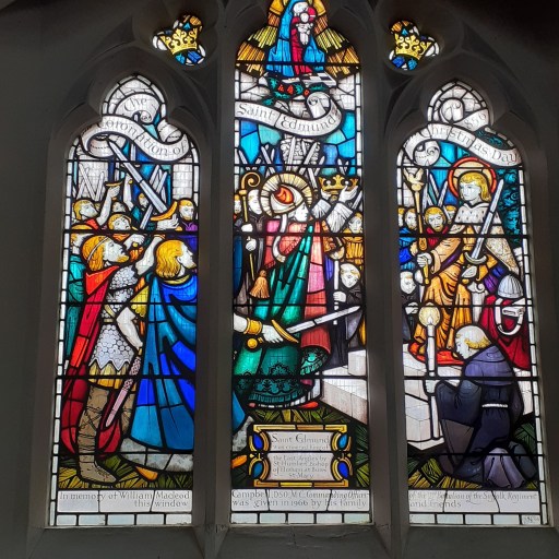
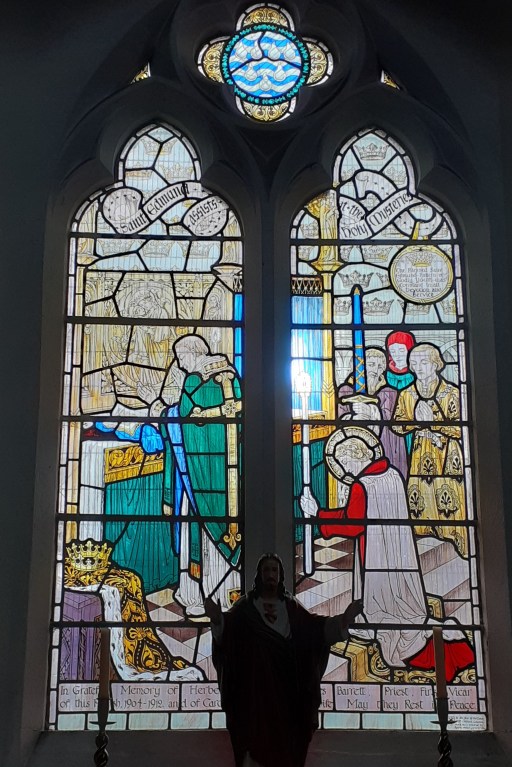
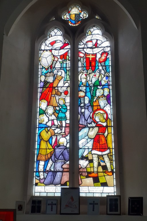
However, a much more fulsome legend of his life soon appeared. and the events of this legend are related in the windows that are shown below in Figure 2. The perspective of some of these is a little odd, largely because I was trying to avoid the above-mentioned dog and his lead whilst taking the photographs. The windows show Edmund’s landing from Saxony at Hunstanton; his coronation; Edmund reading from the psalms, showing hospitality and assisting at mass (illustrating his devotion and humility); Edmund in Winchester (not sure why); his martyrdom at the hands of the Viking Great Army (but not his later beheading); his welcome into heaven and being brought before God by the East Anglian saints Humbert, Felix, and Lady Julian of Norwich; and his shrine at Bury St Edmunds. There is a lot of detail in the windows that reward close scrutiny,
Sailing from SaxonyCoronationReading from psalmsShowing hospitalityAssisting at massAt WinchesterMrrtyrdomKneeling before GodThe shrine
Figure 2. The St. Edmund windows
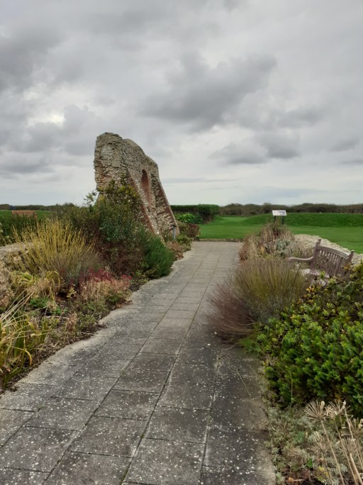
To the north of the village there is another site of relevance to St. Edmunds – the ruins of the old medieval chapel dedicated to the saint, allegedly built to mark the point of his arrival into England – see Figure 3 below. The last photograph shows a wolf carving – commemorating the legend, probably arising from the supposed fact that Edmund was a member of the Wulfinglas dynasty, that the followers of St Edmund, after his death and beheading, found his head protected from further harm by a wolf.
South wall and doorView through south door looking northLooking along nave to east endPosition of altarLooking along nave to west endThe wolf carving
Figure 3. Ruins of St. Edmund’s chapel
* Any such ecclesiastical stair lift should of course have changeable cushions in the correct liturgical colours.
In August 1860 the Rev. Thomas James., M.A.- honorary canon of Peterborough, vicar of Theddingworth, and one the secretaries of Architectural Court of the Archdeaconry of Northampton delivered a lecture to Oakham Literary Institute at the Old Castle Hall of Oakham, on ” Gothic Architecture,” particularly with regard to the history and arrangements of the Church and Castle Hall in Oakham (1). The transcript of his talk can be found here. The speaker was described as “an accomplished ecclesiologist and erudite and painstaking antiquary” and was clearly a major proponent of gothic church architecture in the area.
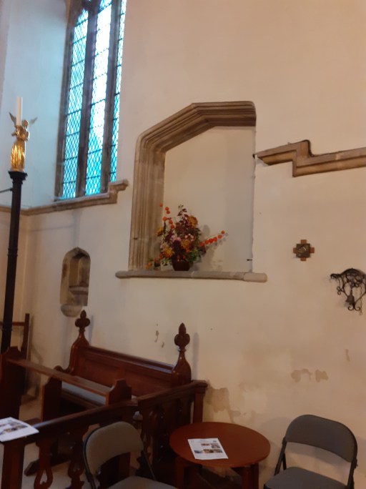
In his talk he mentions two speculations that I wish to consider briefly in this post. Firstly he stated that there was “a cupboard in the eastern wall, behind the altar, which might have been used as a receptacle for relics, or for receiving the stoup of holy water which stood at the chancel door.” Secondly, with regard to the clergy vestry he said, obviously referring to some past time “…the vestry was two storied, in all probability it was formerly used as the dwelling of an anchorite, that being a prevailing custom at one time. There was a similar instance of a two storied room attached to the church at Barnack, near Stamford“. We consider each of these two statements below.
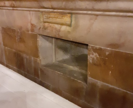
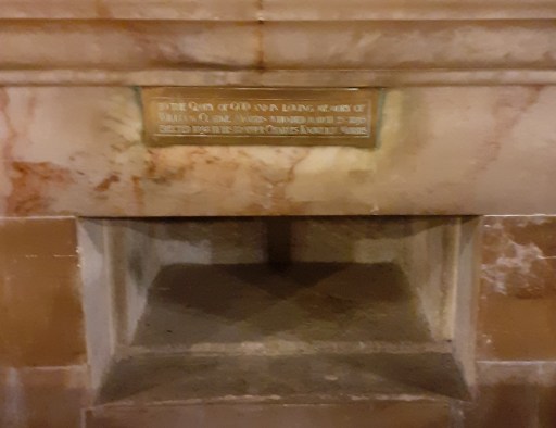
The altar cupboard
The east end of the church was extensively modified by Gilbert Scott in 1858, but probably only from the bottom of the east window upwards, and it would seem, from the description by James, that the altar cupboard, whatever it was, was still in place in 1860. The area was further extensively modified in 1898 when the current Reredos was installed , and the walling and flooring renewed. However there is still a slot behind the altar which almost certainly was created to mark the position of the cupboard (figure 1). So what was it – a reliquary, a place for storage of holy water, or perhaps an aumbry, where the consecrated bread and wind would be kept? There are as far as I know, no historical mention of any relics in All Saints, but a church of its size and significance may well have been graced with them. There is of course evidence of relics at the priory cell at Brooke to the south of Oakham and the Reliquary can be seen in Rutland County Museum. If it were an aumbry for consecrated bread and wine or a storage place for holy water, then it would need to be opened fairly regularly, and its location behind the altar, which would have been standing against the east wall would have made it relatively inaccessible. So it is possible that it was a reliquary, which would not have been opened regularly, but this must remain as speculation.
Figure 1. The slot in the wall at the east end marking the position of the “cupboard”
The Vestry
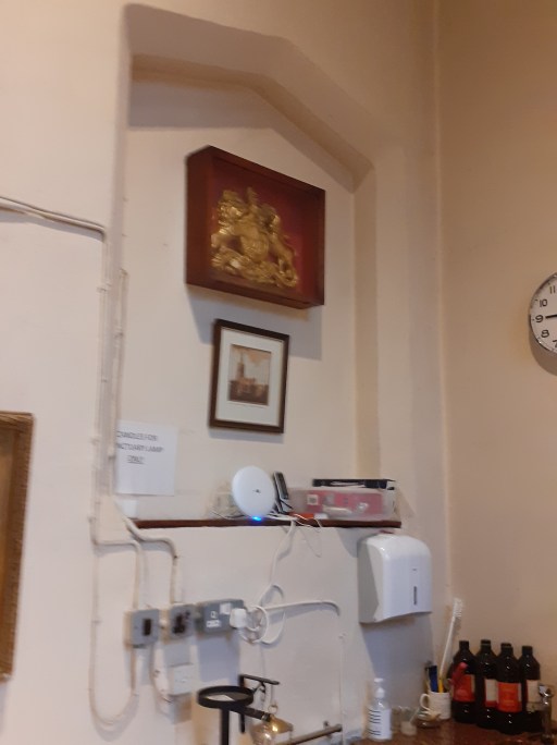
The vestry is thought to have been built around 1480 at the same time as the adjoining Lady Chapel, although this is not certain. It is certainly tall, and could have accommodated a second floor, although there is no current structural evidence for that. One potential feature could be consistent with the idea that and Anchorite hermit (or an Anchoress) resided there, is that there is a blocked up “window” structure in the wall between the vestry and the Lady chapel, which could possibly have been used by the resident hermit to observe the celebration of the mass at the altar below (figure 2). As it stands, the lower edge of this recess is rather too low for it too have been at the level of the floor above, so this might have involved a step down, or perhaps was first built to match the height of an earlier structure on the site of the current vestry. So this perhaps goes some way to bolstering the claim made by Wood, but again there is no certainty.
a
b
Figure 2. The blocked up window structure. a – from the Lady chapel; b – from the vestry. The bottom edge is at the same level in each case.
So to conclude. Whist the presence of relics and hermits in All Saints is a possibility, this is far from certain. As with many Victorian ecclesiologists and antiquarians, the Revd. James may well have let his speculations outrun the evidence.
Additional Note (29/11/24)
After reading the above blog, the Vicar of Oakham, Revd. Stephen Griffiths, sent me the photograph shown in Figure 3 below. This shows two blocked up windows on the east side of the Vestry. From the inside, the lower window corresponds with a recessed cupboard in the wall, which has the appearance of a door, and from the photograph, there seems to be a break in the stone work beneath the window that might indeed suggest it was originally a door. The upper window is similar in form to the stair windows in the tower. Taken together they perhaps suggest a separate entrance with access to an upper level in the vestry. How this relates to the issues addressed in the above blog is not, however, at all clear. All a bit of a mystery.
Figure 3. The east side of the vestry (photograph by Revd. Stephen Griffiths)
In this post we will consider how bus and train transport in Oakham has changed from the 1960s to the present day, for both good and bad. To do so, we will use a variety of historical resources, primarily old bus and rail timetables. We will look at four time slices – at the state of the railways in the early 1960s i.e. before the Beeching cuts; at the bus services and train service provided in the late 1960s, after Beeching but before bus deregulation; in the late 1990s after rail privatization and bus deregulation; and the current situation. The time slices chosen have in effect been determined by what information is available. However, between them they give a clear picture of how bus and train services in Oakham have developed (or perhaps degraded) over the last 50 to 60 years.
Sources and limitations
For the early 1960 rail services we use the following sources:
London Midland Region timetable for 1963 and 1965 (personal collection);
These are quite comprehensive and give a full coverage of the rail services at that time, which is of course before the Beeching Report and associated closures. The sources for the late 1960s are both taken from Timetable World:
London Midland Region timetable for 1969;
Bus timetables for the late 1960s.
Whilst the rail timetables can again be expected to be comprehensive, the bus timetables are probably less so. Finding services through Oakham requires a search of the index for bus companies operating in the area. It is possible that I have missed some potential sources of information, although I believe I have captured most of the main services. What I have almost certainly missed are any very local services operated by small operators in the Oakham district, which simply do not appear on the Timetable World web site. The bus timetables are from the years 19868 and 1969 with one exception from 1973 (for a Saturday only service). For the late 1990s we obtain information from the following sources:
Railtrack Great Britain timetable for 1999 (from Timetable World);
Great Britain Bus Timetable 1999 (personal collection).
The Great British Bus Timetable is a compilation of services from across Great Britain. It admits that it excludes local operators and services of a purely local nature, so again the bus information might not be fully comprehensive here. For the current situation we used information for bus and train times that is available on the web as follows:
In the analysis that follows, we will identify bus and train operators by a two letter code.
BL – Blands of Cottesmore – a local bus company based in a village to the east of Oakham.
BA – Bartons or Barton Tobin Hood – a large regional bus company based around Nottingham, but with a garage in Stamford.
BR – British Rail – the National pre-privatisation rail operator.
CB – CentreBus – an East Midlands regional operator.
CC – Cross Country Trains – the current franchise operator of trains through Oakham, with a wide nationwide network.
CT – Central Trains – a previous operator of trains through Oakham, based in Birmingham with a wide regional network across the Midlands.
EM – East Midlands Railway – the mainline train operator serving the East Midlands cities, that runs occasional services through Oakham (and is, bizarrely, the firm responsible for running the station).
KI – Kinchbus – a small Loughborough based bus company
LR – Lincolnshire Road Car – a large regional company in the 1960s, primarily based, as might be expected, in Lincolnshire.
MR – Midland Red Leicester – the regional operator of the very large Midland Red network that operated buses across the wider Midlands area.
RC – Rutland County Council – which currently operates a small number of services for which no franchise partner could be found.
UC – United Counties Omnibus Company – a large regional company primarily based in the Northampton area.
Analysis
In what follows we consider the public transport services through time in four categories:
Local interurban services to Stamford, Melton Mowbray and Uppingham;
Regional services to Peterborough, Leicester, Nottingham, Grantham and Corby;
Long distance services to Birmingham, Cambridge and London;
Miscellaneous services for which information is incomplete – very local services, long distance coaches etc.
For the first three categories we present the data in tabular form in a consistent format, and then discuss how these have evolved over time. Discussion of the latter category is inevitably rather more diffuse due to the lack of much historical information.
Local interurban services
Tables 1 to 3 show, in standard form, the bus and train services between Oakham and Stamford, Melton Mowbray and Uppingham. Journey times and number of journeys / day are shown. Clearly there are both train and bus options to Stamford and Melton Mowbray, but only bus options to Uppingham. The bus journeys in 1969 and 1999 were provided by major bus operators for which Oakham was at the edge of their operating area – United Counties in Northampton, Lincolnshire road Car, Bartons in Nottingham, Kinchbus in Loughborough. Currently they are provided by more local operators – primarily Blands, but with Rutland County Council running the current Oakham to Stamford service. The bus journey times and service frequencies have remained similar over the period (although note that the former can vary significantly depending on what villages are served on the way between urban centres. The loss of Sunday services is obvious from the data in the tables. What is not so obvious is the fact that evening services on all the bus routes have been significantly cut over the study period.
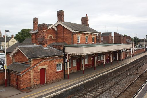
By contracts the train services have seen major improvement. The Leicester to Peterborough shuttles stopped at all the village stations before Beeching and the journey times between Oakham and Melton Mowbray and Stamford were of the order of 20 minutes. By 1969 these stations had closed and the journey times significantly reduced. This reduction has continued up to the present with faster stock being introduced on the line and, most significantly, the number of journeys has increased by a factor of two with the introduction of hourly through Birmingham to Cambridge / Stansted Airport services. These improvements have however resulted in a significant loss of connectivity to the villages where stations were closed in the 1960s.
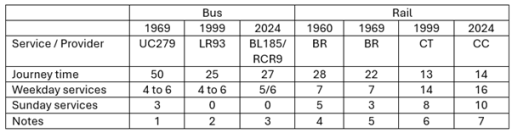
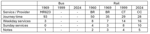
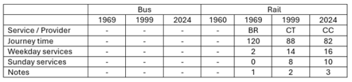
Table 1. Oakham to Stamford
Uppingham to Stamford via Ridlington, Wing, Oakham (Railway Station Crossing), Exton, Whitwell, Empingham and Great Casterton. UC also operated service 280 with one return journey on Fridays only from Oakham to Stamford vis Edith Weston.
Oakham to Stamford via Whitwell, Empingham and Great Casterton.
Oakham to Stamford via Whitwell, Empingham and Great Casterton. BL185 has one service from Monday to Friday and four on Saturday. RCR9 has five services Monday to Friday.
Leicester to Peterborough East via Syston, Frisby, Melton Mowbray, Saxby, Ashwell, Oakham, Manton for Uppingham, Luffenham, Ketton and Collyweston, Stamford, Helpston and (for some journeys) Peterborough North.
Leicester to Peterborough via Melton Mowbray, Oakham and Stamford
Birmingham to Cambridge / Stansted Airport via Leicester, Melton Mowbray, Stamford and Peterborough.
Birmingham to Cambridge / Stansted Airport via Leicester, Melton Mowbray, Stamford and Peterborough. Also, two early morning / late evening EM services from Nottingham to Norwich calling at Loughborough, Melton Mowbray, Stamford and Peterborough (not included in table).
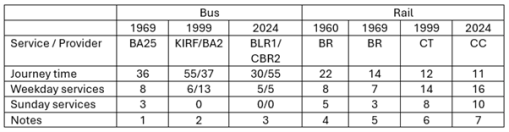
Table 2. Oakham to Melton Mowbray
Melton Mowbray to Oakham (Station Approach) via Whissendine, Ashwell and Langham. Also, four journeys / day Oakham to Langham only.
KIRF (Rutland Flyer) Corby to Melton Mowbray via Uppingham, Oakham and Cottesmore; BA2 Uppingham to Nottingham via Oakham, Langham, Whissendine and Melton Mowbray.
BLR1 Corby to Melton Mowbray via Uppingham, Oakham, Langham and Whissendine; CBR2 is Oakham to Melton Mowbray via Exton, Cottesmore and Whymondham. Also, one BLR4 service per day Melton Mowbray to Peterborough via Oakham and Uppingham (not shown in table).
Leicester to Peterborough East via Syston, Frisby, Melton Mowbray, Saxby, Ashwell, Oakham, Manton for Uppingham, Luffenham, Ketton and Collyweston, Stamford, Helpston and (for some journeys) Peterborough North.
Leicester to Peterborough via Melton Mowbray, Oakham and Stamford.
Birmingham to Cambridge / Stansted Airport via Leicester, Melton Mowbray, Stamford and Peterborough.
Birmingham to Cambridge / Stansted Airport via Leicester, Melton Mowbray, Stamford and Peterborough. Also, two early morning / late evening EMT services from Nottingham to Norwich calling at Loughborough, Melton Mowbray, Stamford and Peterborough (not included in table).
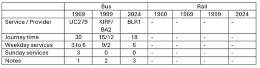
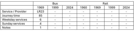
Table 3. Oakham to Uppingham
Uppingham to Stamford via Ridlington, Wing, Oakham (Railway Station Crossing), Exton, Whitwell, Empingham and Great Casterton.
KIRF (Rutland Flyer) Corby to Melton Mowbray via Uppingham, Oakham and Cottesmore; BA2 Uppingham to Nottingham via Oakham, Langham, Whissendine and Melton Mowbray.
Corby to Melton Mowbray via Uppingham, Oakham, Langham and Whissendine
Regional interurban services
In this section we consider the evolution of services from Oakham to the major surrounding conurbations of Peterborough, Leicester, Nottingham, Grantham and Corby (Tables 4 to 8). With regard to Peterborough and Leicester, the same remarks can be made as in the last section in terms of the rail services, with steadily decreasing journey times and a major improvement in service frequency. For both towns there have only ever been occasional and sporadic bus links, addressing specific leisure, employment or educational needs, with long journey times. Direct services to Grantham were an early casualty of service rationalization and were not provided after the early 1970s.
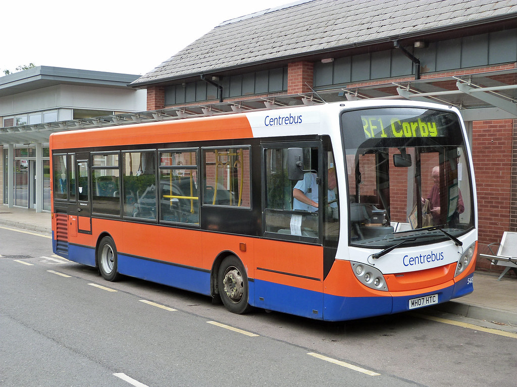
In the early 1960s train services were provided from Nottingham to Melton Mowbray, Oakham, Corby, Kettering and beyond. Services on this line were a major casualty of the Beeching closures and there are now only very limited rail services to both Nottingham and Corby. Whilst there was quite a good bus service from Oakham to Nottingham in 1999, operated by Barton, this did not last and there are now no direct bus services to that city. There are, however, regular services to Corby that run through Oakham to Melton Mowbray. In 1999 these were provided by Kinchbus and marketed as the Rutland Flyer. Now the service is operated by Blands. Journey times are of the order of 40 to 50 minutes.
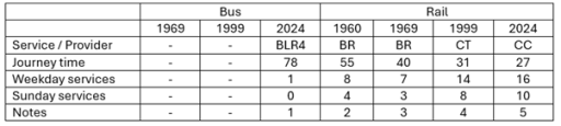
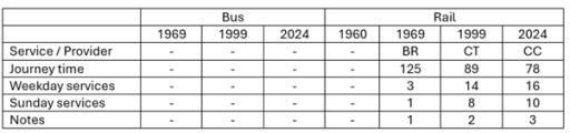
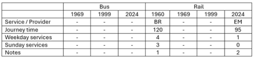
Table 4. Oakham to Peterborough
Melton Mowbray to Peterborough via Langham, Oakham, Uppingham and South Luffernaham.
Leicester to Peterborough East via Syston, Frisby, Melton Mowbray, Saxby, Ashwell, Oakham, Manton for Uppingham, Luffenham, Ketton and Collyweston, Stamford, Helpston and (for some journeys) Peterborough North
Leicester to Peterborough via Melton Mowbray, Oakham and Stamford
Birmingham to Cambridge / Stansted Airport via Leicester, Melton Mowbray, Stamford and Peterborough.
Birmingham to Cambridge / Stansted Airport via Leicester, Melton Mowbray, Stamford and Peterborough. Also, two early morning / late evening trains from Nottingham to Norwich calling at Loughborough, Melton Mowbray, Stamford and Peterborough (not included in table).
Table 5. Oakham to Leicester
Saturdays only. Oakham (Station Road) to Leicester via Braunston, Knossington, Cold Overton and Melton Mowbray.
Leicester to Peterborough East via Syston, Frisby, Melton Mowbray, Saxby, Ashwell, Oakham, Manton for Uppingham, Luffenham, Ketton and Collyweston, Stamford, Helpston and (for some journeys) Peterborough North.
Leicester to Peterborough via Melton Mowbray, Oakham and Stamford
Birmingham to Cambridge / Stansted Airport via Leicester, Melton Mowbray, Stamford and Peterborough.
Birmingham to Cambridge / Stansted Airport via Leicester, Melton Mowbray, Stamford and Peterborough. Also two early morning / late evening trains from Nottingham to Norwich calling at Loughborough, Melton Mowbray, Stamford and Peterborough (not included in table).
Table 6. Oakham to Grantham
Oakham (Railway Station) to Grantham, calling at Cottesmore, Greetham, Market Overton and Thistleton. Also 3 journeys from Oakham to Cottesmore only.
Table 7. Oakham to Nottingham
Nottingham to Uppingham via Melton Mowbray, Whissendine, Langham and Oakham.
Nottingham to Kettering, via Old Dalby, Melton Mowbray, Oakham, Manton for Uppingham, Gretton, Corby and Kettering, Two or three of these were from Nottingham (and beyond) to London St Pancras.
Nottingham to Norwich calling at (Leicester), Loughborough, Melton Mowbray, Oakham, Stamford and Peterborough (early morning and late evening only)
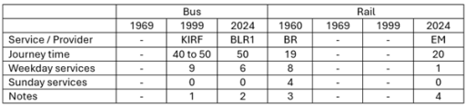
Table 8. Oakham to Corby
Corby to Melton Mowbray via Uppingham, Oakham and Cottesmore.
Corby to Melton Mowbray via Uppingham and Oakham
Nottingham to Kettering, via Old Dalby, Melton Mowbray, Oakham, Manton for Uppingham, Gretton, Corby and Kettering. Two or three of these were from Nottingham (and beyond) to London St Pancras.
Melton Mowbray to London St Pancras calling at Oakham and Kettering.
Long distance services
The three long-distance services we consider are Oakham to Birmingham, Cambridge and London (Tables 9 to 11). All of these are rail based. The first two reflect the changes described above to the Leicester to Peterborough services with a significantly increased number of services and steadily reducing journey times. The London situation is very different. When services ran from Nottingham to London via Oakham in the early 1960s, there were four trains to and from London each day. After Beeching these were withdrawn completely and it is only in recent years that one journey, from Melton Mowbray to London has been reinstated. Thus whilst there has been considerable improvement in east / west connectivity, north / south connectivity has been reduced to a nominal level.
Table 9. Oakham to Birmingham
Birmingham to Cambridge / Norwich via Leicester, Melton Mowbray, Stamford and Peterborough.
Birmingham to Cambridge / Stansted Airport via Leicester, Melton Mowbray, Stamford and Peterborough.
Birmingham to Cambridge / Stansted Airport via Leicester, Melton Mowbray, Stamford and Peterborough
Table 10. Oakham to Cambridge
Birmingham to Cambridge via Leicester, Melton Mowbray, Stamford and Peterborough.
Birmingham to Cambridge / Stansted Airport via Leicester, Melton Mowbray, Stamford and Peterborough. Birmingham to Cambridge / Stansted Airport via Leicester, Melton Mowbray, Stamford and Peterborough
Table 11. Oakham to London
Nottingham to Kettering, via Old Dalby, Melton Mowbray, Oakham, Manton for Uppingham, Gretton, Corby and Kettering. Two or three of these were from Nottingham (and beyond) to London St Pancras.
Melton Mowbray to London St Pancras via Oakham and Kettering
Other services
When looking at the information available from the sources listed above, it is clear that there are two broad categories of bus service that are not fully represented – very local services in and around Oakham and the nearby villages; and long-distance coach services. With regard to the former, it is known that local companies such as Blands provided specific services to places of work and education and indeed that still continues in the latest timetable. These are usually one or two journeys a day with no wider public transport relevance. Als Rutland County Council operate a minibus Rutland Hopper service around the town to out-of-town stores and local villages.
It is also clear that some long distance coaches operated through Oakham, but these are not easy to find, usually occurring in specific operators timetables. For example, in 1968 Barton operated a long-distance coach service between Corby and Glasgow (presumably for steel worker s to visit families), with daytime trips on Sunday, Monday and Wednesday, and overnight trips on Friday and Saturday, that picked up and dropped off at the Crown Hotel. Similarly in 1969 Trent Motor Traction, based in Derbyshire and Nottinghamshire ran weekend services from Derby and Nottingham to Southend on Sea, Cambridge and Clacton that ran through Oakham, picking up and setting down at the Market Place. There were no doubt other similar occasional services.
Conclusions
So what can one conclude from the data presented above? Firstly with regard to rail services, it is clear that there have been major improvements in connectivity to the east and the west, with reducing journey times and increased frequencies. That being said, current reliability and punctuality is poor and requires improvement. Services to the north and south have however seen major degradation and are now only represented by one journey a day to London. With regard to bus services, in some sense these have seen little change, with journey times and frequencies on most routes remaining broadly constant, at least on weekdays. That being said, there have been some losses – to Grantham and Nottingham in particular, Sunday services are non-existent and evening services have been severely cut back, Perhaps more importantly the service times and frequencies that were acceptable in the 1960s now simply represent a very basic service that is not attractive to most car-owning travelers.


