This post contains a transcript and a re-recording of the presentation I gave at the Black Country History Day at the Black Country Museum on November 9th 2024. The title for the day was “Buildings, Heritage and the Built Environment in the Black Country” and was organised by the Black Country Society. It focused on how local buildings and sites are being protected, preserved and presented and how the built environment has been described and visualised by artists, writers and photographers. The programme for the day was as follows.
Tube Town Tales – what the world owes to Wednesbury, Keith Robinson
Rev John Louis Petit’s 19th-century Black Country art: the impact of the Industrial Revolution on the built environment, Philip Modiano
The challenges of rescuing industrial heritage buildings, Mark Davies
Rubery Owen: Exploring the archives of one of Britain’s largest historic privately owned companies – documents, photographs and film
Forging Ahead: Bringing the Halesowen & Hasbury Co-op to Life, Clare Weston
The Black County environment of the mid-20th century through the poetry of Jim William Jones, Chris Baker.
More details of Jim Jones’ life can be found in both the presentation and the transcript below as well in an earlier blog post. The presentation contains both the audio of the poems being read, as well as background slides with illustrative material. The transcript itself contains only one picture, which is of particular relevance to one of the poems.
For those interested in reding more of Jim Jones’ poetry, pdfs of two publications from the 1970s, and a compilation of his Blackcountryman poems can be purchased from the Black Country Society online shop.
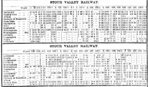
Over the decades I have sporadically and wholly unsystematically been a collector and hoarder of bus and train timetable booklets and leaflets, and despite a recent clear out, the collection still takes up significant shelf space. I have no real idea what to do with it, but it is interesting to look at and ponder. Recently I have become a user of the British Newspaper Archive, and I have just discovered that if you use the correct search terms then a whole load of bus and train timetables published in newspapers can be accessed and downloaded. The positive thing about this is that don’t further reduce my shelf space, although at the moment they are littering my hard drive rather badly. And whilst again, I have no real idea what to do with them, the early ones, from the nineteenth century, are, at least to me, really interesting. In this blog I will discuss just one set of such timetables, from the County Express newspaper that served the areas of Brierley Hill, Dudley and Stourbridge, from Saturday October 24th 1868. In particular I will focus on train services through Dudley station at that time, when there was a very extensive set of services and travel opportunities. Trains no longer serve Dudley of course, so this exercise is somewhat poignant. But first, I will consider Dudley station itself as it would have been in 1868.
Dudley Station
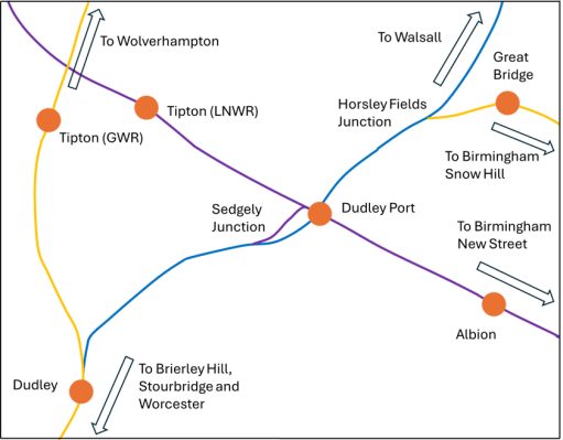
Dudley station is very well described on the Disused Stations web site. In 1868 the track layout had taken on a form that was to continue to exist, with period revisions, for much of the next century. It was in essence two stations. On the west side, there was the GWR station on the former Oxford, Worcester and Wolverhampton line that ran from Oxford, through Worcester, Kidderminster and Stourbridge and on to Wolverhampton. On the east there was the LNWR station that was the terminus of the former South Staffordshire Railway from Burton, Lichfield, Walsall and Dudley Port and also the terminus of the LNWR Stour Valley Line that ran to Dudley Port and joined the main LNWR Wolverhampton to Birmingham New Street Line. Each half of the station consisted of an island platform, with an overbridge connecting them with each other and with the main station entrance on the Tipton Road. There were extensive goods facilities for both the GWR and the LNWR to the north of the passenger station. The map in the figure below shows the station and the lines that pass through it in relation to the local network.
Dudley station and its locality
Services using the station
The County Express gives timetables for four distinct services that used the station in 1868.
Services on the GWR London Paddington to Wolverhampton route via Worcester.
Services on the GWR Great Malvern to London Paddington route via Birmingham Snow Hill.
LNWR services on the South Staffordshire line to Birmingham New Street and London Euston via Walsall.
LNWR services on the Stour Valley route to Birmingham New Street and London Euston via Dudley Port and Smethwick.
I will consider each of these in turn, and try to describe the nature of the services, their frequency and journey times. But first there are two caveats that need to be made. Firstly, as can be judged by the example at the top of this post, the timetables on the scanned pdf of the County Express are not always easy to read, and this might lead to some minor errors in any numbers I quote, although the big picture will not be affected. Secondly, and more importantly, the timetables read as if some of the local services become through trains to long-distance destinations. I suspect that this might, in places, be hiding journeys where a change of train is required. I will try to highlight my uncertainties in this regard as they arise.
GWR London Paddington to Wolverhampton via Worcester
There were eleven southbound services that called at Dudley on this route on weekdays, and five on Sundays. The corresponding numbers for northbound services were thirteen and seven. Those going south called at some combination of Netherton, Round Oak, Brierley Hill, Brettell Lane, Stourbridge, Hagley, Churchill, Kidderminster, Fearnall Heath, Worcester and stations to Oxford and London; and those going north called at Tipton, Princes End, Daisy Bank, Bilston, Priestfield and Wolverhampton. These stations were not always at their final or current locations – for example Netherton was moved northwards when the Dudley to Old Hill line was opened in 1878 to be north of junction, and Stourbridge was moved south and renamed Stourbridge Junction when the Town branch was opened in 1879.
There were five weekday trains in each direction that ran through to Paddington, with most of the rest running to Worcester. Journey times were approximately as follows.
Dudley to Wolverhampton – 20 to 25 minutes Dudley to Stourbridge – 30 to 40 minutes Dudley to Worcester – 1 to 1.5 hours Dudley to London Paddington – 4.5 to 6.5 hours
GWR Great Malvern to London Paddington via Birmingham Snow Hill
There were eleven trains from Dudley to Birmingham Snow Hill and beyond on this route on weekdays, and six on Sundays, with ten and six in the Great Malvern Direction. Those going to Malvern called at some combination of Stourbridge, Kidderminster and Worcester (and not the intermediate stations) and those going to Snow Hill and Paddington ran along the LNWR line through Dudley Port (not stopping) to Horseley Fields junction and then called at Great Bridge, Swan Village, West Bromwich, Handsworth, Soho, Hockley, Birmingham Snow Hill , Warwick, Leamington, Oxford and Paddington.
Five weekday services ran through to Paddington with 6 in the reverse direction, with the others terminating either at Snow Hill or Leamington. Some of the Malvern services terminated at one of the intermediate stations. Journey times were approximately as follows.
Dudley to Birmingham Snow Hill – 30 to 35 minutes Dudley to London Paddington – 4 to 6 hours Dudley to Stourbridge – 15 to 20 minutes Dudley to Worcester – 1 to 1.5 hours Dudley to Great Malvern – 1.5 to 2 hours
Thus, the times from London to Paddington were similar on both GWR routes. This route gave a much faster trip to Stourbridge, Kidderminster and Worcester as trains did not call at the intermediate stations. The Disused Stations site suggest that the particular utility of this route was that fast trains could be turned around at Dudley and thus ease potential congestion at Snow Hill.
LNWR Dudley to Birmingham New Street via Walsall
In the County Express this is referred to as the South Staffordshire Railway, (SSR) although by 1868 it was fully incorporated into the LNWR The SSR main route was from Derby to Birmingham New Street via Burton upon Trent, Lichfield and Walsall. The services outlined in the County Express were thus on the southern leg of the SSR and operated as stopping services from Dudley to Walsall and Walsall to Birmingham. The timetable implies that these were through services, although this would have required a quite rapid reversal at Walsall (perhaps a change of engines, or perhaps passengers were required to change). There were thirteen services form Dudley to Birmingham New Street on weekdays and four on Sundays, with thirteen and fivein the opposite direction. The trains called at Dudley Port, Great Bridge, Wednesbury, Walsall, Bescot Junction, Newton Road, Hampstead and Great Barr, , Perry Barr, Aston, Bloomsbury, Lawley Street and Birmingham New Street. Only about half the trains called at Lawley Street, Bloomsbury and the stations from Pery Barr to Walsall. The approximate journey times were as follows.
Dudley to Walsall – 25 to 30 minutes Dudley to Birmingham New Street – 1 to 1.5 hours
The journey from Dudley to Birmingham was thus a lengthy one and probably not attractive, and the service was clearly aimed at serving local traffic between Dudley, Walsall and Birmingham.
LNWR Dudley to Birmingham New Street and London Euston Square via Dudley Port and Smethwick
This LNWR route is described as the Stour Valley Railway by the County Express. It gained its name from the original intention to extend it over the Dudley ridge into the Stour catchment to the south. This aim was abandoned quite early, and though it retained its name, it remained stubbornly in the Tame catchment. There were fifteen services from Dudley to Birmingham and London on weekdays and seven on Sundays, with fifteen and six in the opposite direction. Trains called at Dudley Port (via the loop at Sedgeley Junction), Albion, Oldbury and Bromford, Spon Lane, Smethwick, Soho, Edgbaston and New Street, and then onto Coventry, Leamington (via the LNWR Kenilworth loop), Rugby and Birmingham. Six weekday up trains continued to London, with the others terminating at either Birmingham or Leamington. Approximate journey times were as follows.
Dudley to Birmingham New Street – 30 to 40 minutes Dudley to Leamington – 1.5 to 2 hours Dudley to London Euston – 3.5 to 4.5 hours
The times from Dudley to both Birmingham and London were thus both very competitive with others.
Other services
The County Express gives details of some other services that it no doubt felt were of interest to its readers.
LNWR London to Birmingham, via Coventry and Rugby i.e. not diverting to Leamington so offering a more rapid journey to London than the Stour Valley Railway, although a change at New Street would be required.
LNWR Birmingham to Wolverhampton and Liverpool, offering connections in both directions at Dudley Port.
The GWR Stourbridge Extension Railway – from Stourbridge to Birmingham Snow Hill. At this stage this was still an independent company that wasn’t completely taken into the GWR until 1870.
The GWR Severn Valley Railway from Hartlebury to Bewdley, Bridgenorth to Shrewsbury, although travel from Dudley would have required rather lengthy trips to Hartelbury and some rather slack connections and would not have been particularly attractive. In 1868 the Kidderminster to Bewdley line, which would offer a shorter route, had not yet been constructed.
The GWR line from Bewdley west to Tenbury and Wooferton, with connections to Hereford, which would have required a change from the Severn Valley railway at Bewdley. It is unlikely that many from the Dudley area made this rather rambling cross-country trip.
A typical day at Dudley station
The table below shows the arrivals and departures at Dudley station on a weekday in 1868. It can be seen to be very busy, even without including the very numerous freight workings, with ninety three services in total from 6.30 in the morning till 22.55 in the evening. Note I use the modern form for specifying time, which has the advantage of being able to be used to calculate journey times using EXCEL.
Company
From
Arrive
Depart
To
SVR
Birmingham NS
06:30
GWR
06:40
London Paddington
SVR
06:55
London Euston
SSR
07:35
Birmingham NS
GWR
08:10
Leamington
SVR
Birmingham NS
08:13
GWR
Wolverhampton
08:05
08:15
London Paddington
GWR
Birmingham SH
07:55
08:15
Great Malvern
SSR
Birmingham SH
08:24
GWR
Worcester
08:21
08:29
Wolverhampton
SVR
08:45
London Euston
GWR
Kidderminster
09:10
SSR
09:15
Birmingham NS
GWR
Kidderminster
09:10
09:20
London Paddington
SVR
09:25
Leamington
GWR
09:30
London Paddington
SSR
Birmingham NS
09:34
SSR
09:50
Birmingham NS
SVR
Birmingham NS
09:53
SVR
London Euston
10:03
SVR
10:10
Birmingham NS
GWR
Worcester
10:32
10:33
Wolverhampton
SSR
Birmingham NS
10:35
SSR
10:45
Birmingham NS
GWR
Honeybourne
10:55
10:57
Wolverhampton
GWR
Wolverhampton
10:55
11:00
GWR
Great Malvern
10:55
11:00
London Paddington
GWR
Leamington
10:46
11:00
Kidderminster
SVR
11:25
London Euston
SVR
London Euston
12:00
SVR
12:18
Birmingham NS
SSR
12:20
Birmingham NS
GWR
Wolverhampton
12:35
12:38
London Paddington
GWR
London Paddington
12:33
12:38
Great Malvern
SVR
London Euston
12:43
GWR
London Paddington
12:45
12:50
Wolverhampton
GWR
Great Malvern
12:45
12:55
Birmingham SH
GWR
London Paddington
13:33
SSR
Birmingham NS
13:35
SVR
London Euston
13:45
GWR
Wolverhampton
13:48
13:50
Worcester
SSR
13:50
Birmingham NS
SVR
13:53
Birmingham NS
GWR
London Paddington
14:14
14:17
Wolverhampton
SVR
London Euston
14:20
GWR
Great Malvern
14:14
14:23
London Paddington
SVR
14:30
Birmingham NS
SVR
15:00
Birmingham NS
GWR
Wolverhampton
15:02
15:04
Worcester
GWR
London Paddington
14:33
15:04
Great Malvern
GWR
London Paddington
15:20
15:24
Wolverhampton
GWR
Wolverhampton
15:20
15:24
Worcester
GWR
Great Malvern
15:20
15:28
Leamington
SSR
Birmingham NS
15:35
SVR
London Euston
15:50
GWR
Stourbridge
16:25
16:28
Wolverhampton
SSR
Birmingham NS
16:40
SVR
16:40
Leamington
GWR
London Paddington
16:35
16:44
Great Malvern
GWR
Wolverhampton
16:43
16:45
London Paddington
GWR
Stourbridge
16:23
16:45
Oxford
SSR
17:15
Birmingham NS
SVR
17:35
London Euston
GWR
Leamington
17:35
17:39
Stourbridge
GWR
Wolverhampton
17:35
17:40
London Paddington
SVR
Leamington
17:55
GWR
18:00
London Paddington
SVR
18:20
Leamington
SSR
18:30
Birmingham NS
SVR
London Euston
18:35
GWR
Worcester
18:40
18:43
Wolverhampton
GWR
Birmingham SH
18:40
18:45
Stourbridge
SSR
Birmingham NS
19:05
GWR
London Paddington
19:28
19:30
Wolverhampton
GWR
Wolverhampton
19:25
19:30
Evesham
GWR
London Paddington
19:24
19:30
Great Malvern
SSR
19:30
Birmingham NS
GWR
Great Malvern
18:38
19:40
Birmingham SH
SVR
Birmingham NS
19:40
SVR
London Euston
20:33
SSR
Birmingham NS
20:43
SSR
20:50
Birmingham NS
GWR
Wolverhampton
20:55
21:00
Kidderminster
GWR
Leamington
20:55
21:00
Kidderminster
SVR
21:10
Birmingham NS
SVR
London Euston
21:38
GWR
Stourbridge
21:55
21:57
Wolverhampton
GWR
Kidderminster
21:55
21:58
Birmingham SH
SSR
Birmingham NS
22:06
SVR
Leamington
22:30
GWR
London Paddington
22:33
22:36
Wolverhampton
SVR
22:45
London Euston
SSR
Birmingham NS
22:55
Weekday departures from Dudley in 1868
A reflection
The information set out above causes me to reflect on why such a vibrant railway scene was swept away in the 1950s and 1960s, and has left Dudley as one of the largest towns in England without a mainline railway service. The immediate reasons are to be found of course in the post war situation of the 1950s and 1960s – the decline of old industries, and the increasing dominance of road transport – but it seems to me that the seeds of this decline were planted in the early days of the railways in the region. Firstly, in the early days, the movement of freight, and in particular coal and iron products, was as important to the railway companies as passengers. This led to the locations of railway lines primarily in areas where there was significant industrial activity, rather than in areas of habitation. And when these industries eventually declined, there wasn’t the reasonably affluent population base to continue to support the railway network as a passenger only system. Secondly, inter-company competition resulted in competing lines – and in particular duplication of major stations in Wolverhampton and Birmingham. Again, in a period of post industrial decline, there was bound to be rationalisation, and this rationalisation needed to provide for the remaining freight, express trains and passenger trains. The result of this, the development of spatially constrained two track Stour Valley line as part of the West Coast route, inevitably meant that local services, would be squeezed out for capacity reasons. And thirdly with regard to Dudley itself, its geography made it vulnerable – sitting on top of a north-south ridge that was best approached by railways along the ridge rather than from either side, which resulted in it being bypassed by the major east / west through lines, and left isolated when the downturn came. The only main line to pass through the town was that of the OWWR / GWR, which in reality was a series of linked local services, with the long distance journey times to London being too great to be competitive, at least north of Worcester.
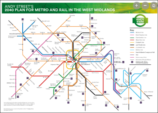
Could things have been different? Perhsps with a more centrally and strategically planned railway system that might have been the case, and a sustainable pos-industrial railway might have emerged in the Dudley area. But that is an unknown – and governments have not always shown themselves as being able to think strategically, at least where railways are concerned. But perhaps there is hope for something better – for example see Andy Street’s ambitious (and probably unrealistic) plan for metro expansion in the graphic below – although the ludicrous costs and construction times of tramways in the UK need to be massively reduced if they are to reach their full potential. But that, as they say, is another story.
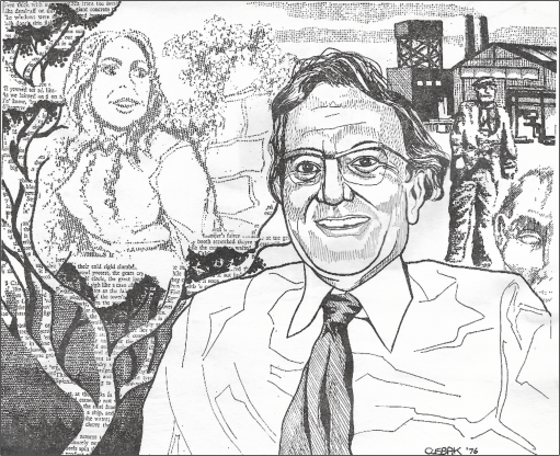
On November 9th 2024 as part of the Black Country History Day to be held the Black Country Living Museum in Dudley, I will be presenting (with help from Emma Purshouse) some of the poetry of the Black Country poet Jim William Jones, to illustrate the industrial, social and built environment of the region in the second half of the 20th century. Jones was a sharp eyed observer of his beloved Black Country and his poems give a deep insight into the area and its people over that period. This is a rather different way of “doing” history, but hopefully one that will both entertain and inform. I write below to give some brief details of his life and work, since this information is not generally available elsewhere.
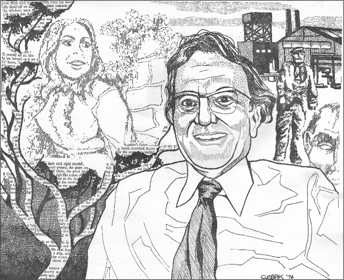
J W Jones by CLEBAK, From Black Country Society Calendar collection 1976
Jim William Jones was born in Coseley on February 15th, 1923, and spent his childhood and school years there. After leaving school he began work with the engineering firm Joseph Sankey and Sons as a junior clerk. He was conscripted into the army at the age of 18 in 1941, taking part in the Normandy landing in 1944 and also serving in India and Ceylon, reaching the rank of Warrant Officer. After the war he returned to Sankey’s and was trained in works management, before leaving industry to join local government in 1955 where he worked in education administration, marrying Jesse Ralphs at Wednesbury in that year. He was a qualified teacher of speech and drama and a member of amateur dramatic societies, hosting a radio programme on Beacon Radio and working with the Black Country folk music group Giggetty. He had a strong Christian faith and was a gifted speaker and Methodist local preacher. He became a very well-known Black Country poet, both for his dialect poetry (Black Country ballads) and for his poetry in more conventional English. Some of these can be found in three small publications by the Black Country Society – “From under the smoke” from 1972, “Factory and Fireside” from 1974, and “Jim and Kate” from 1986, all sadly long out of print. He contributed numerous poems to the first 25 years of the Society magazine, the Blackcountryman from 1967 to 1992. He died in 1993.
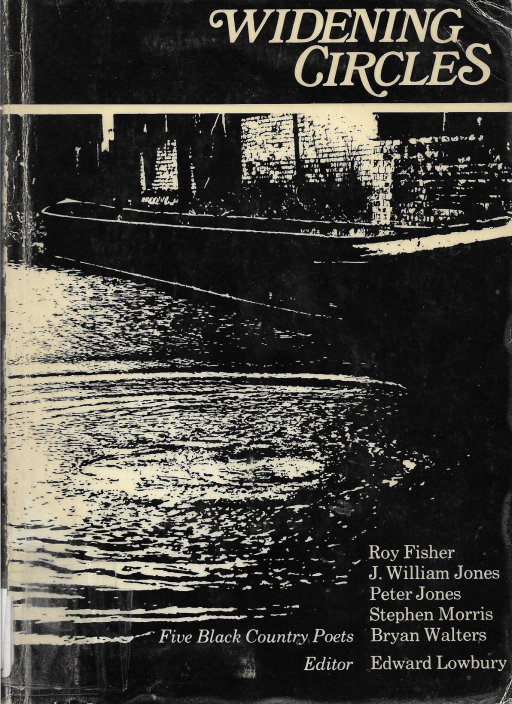
Some of Jim Jones poems were included in a 1976 anthology “Widening circles” edited by Edward Lowbury. Following Jones’ death, Lowbury wrote an appreciation for the Blackcountryman (26.4, 1993). He acknowledged the humour and the pathos in the dialect ballads, which at the time of publication of “Widening Circles” he felt to be more successful than the poems in standard English. By 1992 however he had somewhat modified his views and concluded that his standard English poems were perhaps “nearer to the heart of poetry than the more immediately entertaining dialect ballads”.
In a much later Blackcountryman article (45.3, 2012) Trevor Brookes again writes in appreciation of Jim Jones, and in particular his dialect poetry, emphasising that as well as humour, they contained much that showed a profound understanding of people and their lives. He regretted that these were not easily available, being scattered across many newspapers and other publications, and not accessible to modern readers.
Personally, I first became aware of Jim Jones work in the early 1970s, when my mother gave me a copy of “From under the smoke” as a Birthday present. This little volume became a prized possession and has travelled around the country with me over the last 50 years, regularly read and re-read.
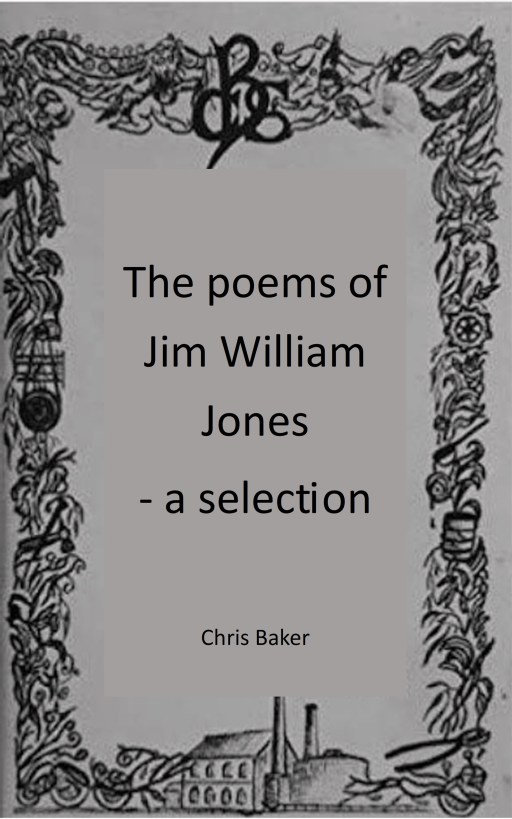
To enable others to either reacquaint themselves with his work, or to enjoy it for the first time, some of Jones’ poems have ben published in a short series of Black Country Society blog posts from 2022 that can be found at the links below.
In addition, the Black Country Society has scanned “From under the smoke” and “Factory and Fireside” and these are available for members on the Society web site (password required). I have also produced a compilation of 33 of his poems that span the period from 1968 to 1992 – from “From under the Smoke”, “Factory and Fireside” and the Blackcountryman. This is again available to Society members on the web site. These three volumes will be available for purchase as pdfs from the Society online shop at some point in the near future.
Most, but not quite all, of the poems in the compilation are in standard English. Another volume could easily be produced containing a selection of his dialect poetry, but as Trevor Brookes noted, these are more scattered, and the collection of them would be a major task. Nonetheless it is perhaps something I will attempt in the future.
As I sit down to write this post, I find it hard to believe that there is anyone out there who will be interested in the ramblings that follow. But perhaps there are some from Pensnett who are as historically nerdy as I am……
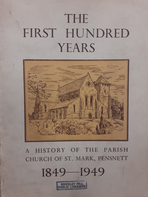
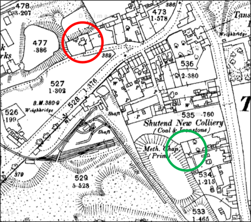
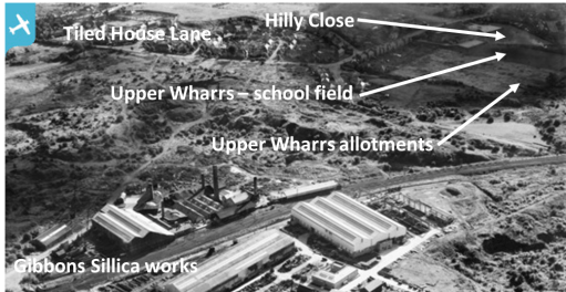
In researching the history of Pensnett over the last few years, and in particular the history of the clergy of St Mark’s Church, I have come across mentions of a mission chapel in the Tansey Green area, but haven’t been able to find any further details or to locate where it was situated. There was another mission chapel in the parish of course, in Bromley, that is much better documented and had a long history. However, I have recently come across a 1949 history of the church by A Sergeant and L U Smith, written to mark its centenary (Dudley Archives LS9582/4B/21) . In that booklet there is the following little bit of information about the Tansey Green Mission Church.
In 1849 the village of Pensnett was much smaller than now, consisting of a straggling line of houses and small shops along the south side of the main road, with a few short streets leading off it to the south, The parish, however, comprised a much larger area, and in it there were two other villages or hamlets. One of these was Tansey Green, where some time about the 1860’s a small mission room was founded. No records exist of this mission apart from some notes in the Services register of the number of communicants. In the year 1888 they numbered 17 in all. Some old residents of the parish still remember the tiny mission room standing on a site on Dreadnought Road which has. now been excavated as a marl-hole, The Mission room itself was demolished some years before the turn of the century.
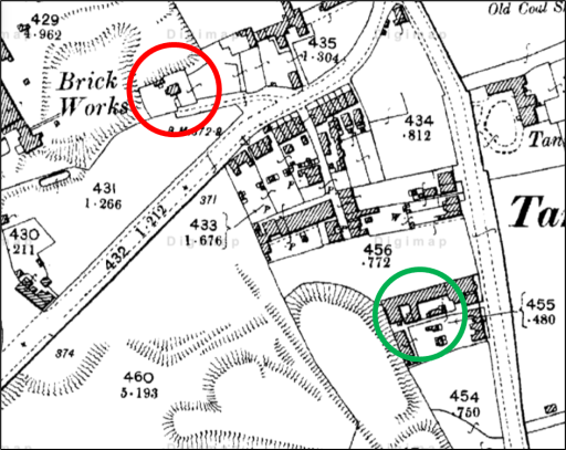
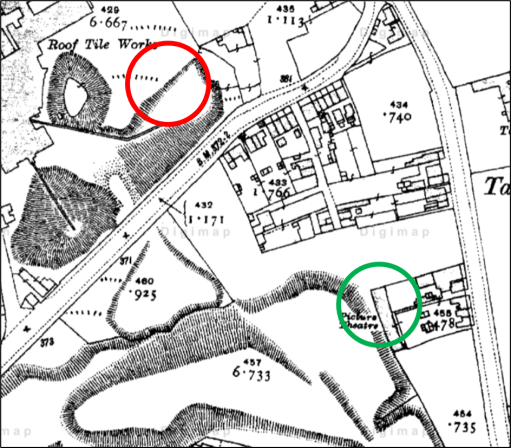
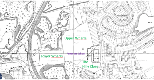
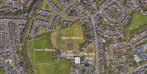
This short extract gives enough information to determine the location of the church. The three maps below show the Ordnance Survey maps from 1880, 1900 and 1910. Dreadnaught Road (or Nailor’s Row as it was known in the mid 19th century) can be seen extending from the bottom left of the figures to the junction with Tansey Green at the top right. The building which I think must contain the chapel is circled in red – there seems to be no other option. It can be seen to be in existence in 1880 and 1900, but by 1910, its location was the centre of what was presumably a marl hole for the adjacent brick works. This isn’t quite consistent with the extract from the history above, as the building is still shown on the 1900 map and had not been demolished by then. This could be due to the unreliable oral memories on which the 1949 booklet extract was based. or simply that the map details were slightly out of date.
1880
1900
1910
Two further points can be made. Firstly the mission chapel was very close to the Shut End Primitive Methodist church (shown by a green circle), which had a a large local congregation – so perhaps there was some level of competition there between the established church and the non-conformists. But note that the congregation abandoned that chapel in 1896 due to mining subsidence and moved to a new location on Commonside and the building became a picture house – one of the earliest in the Black Country. Secondly the building that I have identified can also be seen, with a very similar shape and ground plan in the Fowler maps of 1822 and 1840, and is listed in the Directories to those maps as “house and garden“, owned by John Hodgetts Hodgetts-Foley and occupied by John Colbourne in 1822, and owned by James Foster and occupied by Thomas Bradley in 1840. It would thus appear that the Mission Chapel was simply a converted house or part of a house.
But beyond that there is very little to say, although I find it satisfying that I have at last been able to locate where the chapel was actually situated. I am still left wandering if this is of interest to anyone else at all!
This is the second of two blogs that set out a timeline of the destruction by fire and subsequent demolition of the Crooked House in Himley in early August 2023, through links to local and national press reports. It covers the period from January 2024 onwards. Earlier news items can be found in the first blog here.
In the days after the fire, there were many, very similar, press reports and thus there has been a need to be selective. In what follows, I thus use three main sources.
BBC local and national news websites, which was, and continues to be, the most comprehensive source.
The Express and Star website, which gives a local perspective. Note that many of the articles that are linked require free registration to be read.
The Guardian website – although many national newspapers reported the story in early August, the Guardian’s was probably the most comprehensive and, through its columnists, the most reflective.
I also include articles from other sources where they complement the above, including a few from overseas to demonstrate the reach of the story. I will update this list at intervals over the coming months.
In addition to the news links, there are two Facebook pages that contain news and (often robust) comments covering a range of opinion.
In histories of specific places in the Black Country, the first paragraph often begin in a similar way to that of (1) with regard to West Bromwich.
“Of the pre-conquest history of West Bromwich, we know practically nothing.”
There are a number of reasons for this lack of knowledge, but perhaps the main one is that much of the evidence of the remote past has been destroyed in the rush to industrialisation in the eighteenth and nineteenth centuries. That being said, I want to show in this blog, that by considering evidence from a wide variety of sources over the entire region, it is possible to say something about the pre-Domesday history of the area, even if only in the broadest outline.
I will look at the material that exists chronologically – the stone ages, bronze age, iron age, the Roman period and the Anglo-Saxon period, before looking in a little more depth at the Domesday record itself. But we begin by defining an area of study.
Defining the Black Country before it was black.
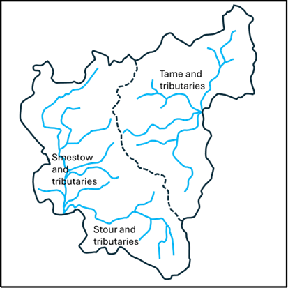
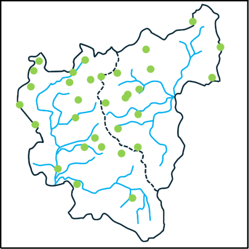
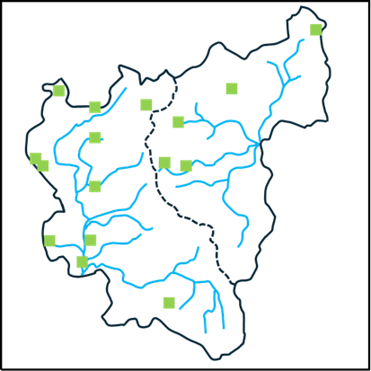
The first question that arises is what area we should consider? The concept of the Black Country as such is of course a creation of the 19th century, and even today, there is no consensus on its extent. Some would argue that it is confined to the area of the South Staffordshire coalfield, others that it is the area of the current boroughs of Dudley, Sandwell, Walsall and Wolverhampton. The status of places around its periphery are argued over endlessly (and vehemently). The only consensus is that Birmingham isn’t part of it. But none of these definitions are of relevance to the period before Domesday, when the area was wholly rural. So, in what follows, I have chosen major natural features to define the area of interest – basically the catchments of the upper Stour and Smestow, and of the headwaters of the Tame. These are shown in Figures 1a and 1b, with the former identifying the rivers and the latter showing the position of the major modern towns in the area. The catchment maps are taken from (2) and (3). It should be noted, that as with everything else in the Black Country, the precise locations of the streams shown in these figures owe a great deal to human activity and may well have been different in the periods we are considering. The boundary between the two catchments, shown by the dotted line, is a continuation of the Pennine chain – the major watershed of England, at this point dividing the headwaters of the Rivers Severn and Trent. The area chosen corresponds roughly to what most would define as the Black Country, although they contain sizeable rural areas to the west in the modern South Staffordshire district and to the south, in north Worcestershire and do not contain the Smethwick and Handsworth areas. This will not please all readers, but a least offers a geographically consistent area – and indeed on that will be seen proves historically useful to consider. It has the potential to offend almost everybody!
(a) (b)
Figure 1. Definition of the study area: a – river catchments, b – location of modern towns.
The Stone and Bronze Ages
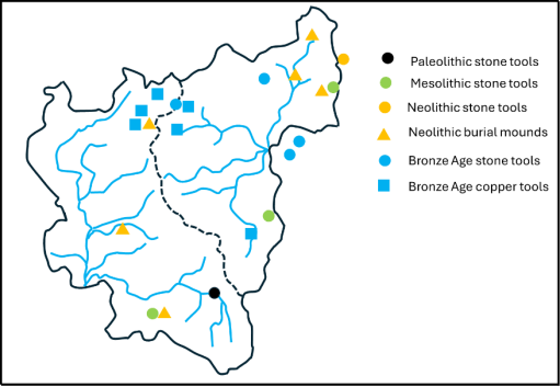
Reference (4) gives an excellent overview of archaeological finds in the area of the Black Country from the Palaeolithic era through to the Roman period. The information presented there is summarised in the map shown in Figure 2 for the Palaeolithic (950,000-9500 BC), Mesolithic (9500-4000 BC), Neolithic (4000-2400 BC) and Bronze Ages (2400-700 BC). (4) gives more detail of the various finds, and only some broad points will be made here. The first and most obvious is that the majority of finds lie just outside the modern urban area to the northeast and the south, or in rural enclaves within it (such as the Sandwell Valley and Barr Beacon). This is almost certainly due to the destruction of archaeological material by industrialisation. Secondly however, there do seem to be a couple of clusters -one in the Aldridge area around Castle Old Fort, and one on the watershed around Wolverhampton. But the huge time period under consideration needs to be borne in mind – these finds were from a wide variety of periods. Nonetheless they do suggest that there was some limited habitation of the area in the prehistoric periods.
Figure 2. Archaeological finds in the Stone and Bronze ages drawn from information in (4).
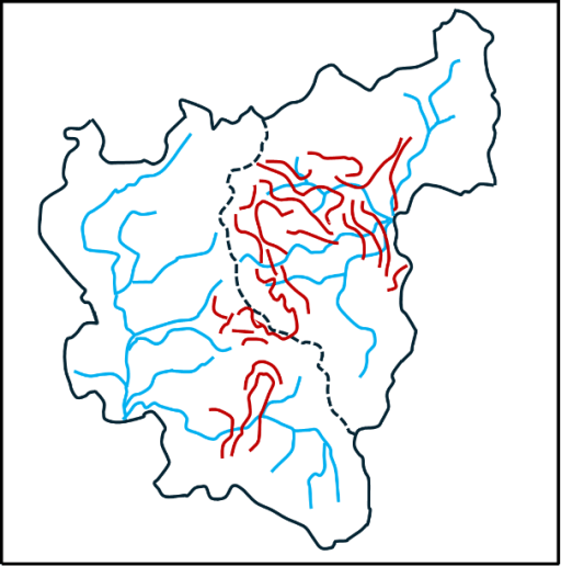
The Iron Age
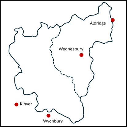
Now let us turn our attention to the situation in the Iron Age before the Roman invasion (700-43 BC). There is in fact very little that can be said with any certainty. However, there are a small number of hill forts in the area – three just outside the study zone at Wychbury in the south (4) Kinver in the southwest (5) and at Castle Old Fort near Aldridge in the northeast (6). There was also probably one at Wednesbury within the study area, although the evidence for this is recent and probably not conclusive (7). These are shown on Figure 3 and three of them seem to line up nicely in a southwest / northeast direction. The spacing along the line suggest that there may also have been one at Dudley on the boundary between the catchments, the traces of which will have been long obliterated by the castle. The configuration suggests a defensive alignment – but who was defending what from who is not in any sense clear. Copper horse bridal fittings have also been found at Wychbury and Castle Old Fort (4).
Figure 3. Iron Age hill forts.
The Roman Period (43 BC – 400AD)
The first truly historical fact about the area that can be relied on is that there were a number of Roman army marching camps in the Greensforge area (8) – see Figure 4. In total there seem to have been two auxiliary forts and five marching camps, which can be dated to the early years of the Roman invasion (45AD to 80AD). They were probably used as the Roman army pushed north and west into England, but also seem to have an intensive period of occupation around the Bouddican revolt of 60AD. These camps were short lived, and there is no evidence of occupation after about 80AD. There is however some evidence of civilian occupation close to the site near Camp Hill, throughout the Roman period (8). An intensive network of roads also remained. These linked into the major arteries of Watling Street to the north and Ryknield Street to the east (figure 4). The importance of Greensforge seems to have been as a ford over the River Smestow. The roads that converge there can be identified with some confidence are as follows (9).
1. A road to the south, to the salt producing areas at Salinae, modern day Droitwich.
2. A road to the north to Pennocrucium, modern day Water Eaton, on Watling Street.
3. A road to the northwest to the major city of Viroconium (Wroxeter), with a branch to Uxacona (Redhill), again on Watling Street.
4. A road to the west to Bravonium near Leominster –presumably with a crossing of the Severn near Quatford, south of Bridgnorth.
Figure 4. Roman Roads in the Black Country
All of these roads can be traced, at least in part, on modern maps and on the ground. Note that the roads from Salinae, through to Viroconium, and onwards to Chester, formed a major “saltway” for the transport of that precious commodity. In addition, the existence of another road can also be indirectly inferred. – from Letocetum (Wall) on Watling Street, south of Lichfield, possibly via Wednesbury before passing through The Straits in Sedgley (another name often linked with Roman Roads) and then heading for Greensforge (10). A further road that probably ran northwest from Metchley in the south to Pennocrucium on Watling Street, can be traced on the ground at its southern and northern ends. Thus, it is likely that there were two roads crossing the Black Country from southwest to northeast and southeast to northwest, that would have crossed in the vicinity of Wednesbury. The precise line of these roads has again been obscured by industrialisation.
Such a road network would form an important focus for both military and civilian business, and as noted above, it is more than likely that there was some sort of small-scale occupation at Greensforge throughout the Roman period. One might expect something similar in the Wednesbury region.
In terms of Roman political structures, the Black Country sat close to the boundaries of three civitas or tribal territories – those of the Cornovii in the upper Severn Basin, the Dobunni in the lower Severn basin, and the Corieltauvi, largely in the Trent basin. Although it is not possible to be sure of the boundaries, the territory of the latter was probably to the east of the main English watershed that passes through Sedgley and Dudley. In addition, it is likely that this ridge was also the boundary of two of the late Roman provinces – that of Britannia Prima to the west and Flavia Caesariensis to the east. (4) reports that a Dobunnic coin has been found at Lutley in the south of the study area.
Many modern historians of that period would see continuity between these civitates and late Iron Age tribal groupings, which would place the Black Country on the boundary between three different tribal groups. Thus, in general terms, the Black Country before and during the Roman period would seem to have been a border zone between different tribal groupings, but nonetheless well traversed by both the invading Roman armies and the traders that would have followed in their wake.
The Anglo-Saxon period (400 -1066 AD)
After the Roman armies left Britain in the early firth century, the traditional view has been that the native Britons were gradually pushed westward into Wales and Cornwall by the military force of invading Anglo-Saxon armies and a number of Anglo-Saxon kingdoms were established. Over the last few decades, a great deal of archaeological evidence has emerged to show that it was a lot more complicated than that. There were undoubtedly migrations of Germanic speaking people from Europe, firstly in the service of the native British population and later in conflict with them. But there is also much evidence of continuity of agricultural practices and political systems that are simply not consistent with a wholesale replacement of one people by another (11, 12), Genetic evidence, which needs very careful interpretation, suggests that there is a broad similarity of genetic background of all peoples across England and Wales, although there are some very distinctive local genetic variations that could possibly be linked to specific migrations (13). Similarly, there is evidence that the replacement of the Celtic British language (old Welsh) by a Germanic form (proto-old English) was not a uniform process with some limited evidence emerging that Germanic languages were spoken in England during the Roman period (14), and of the survival of pockets of British speakers across England into the 9th and 10th centuries (11).
So, we have a very complex picture emerging of the movements of peoples and languages across England in the immediate post Roman era. What can be said with a little more certainty is that there were significant movement of people in the second half of the sixth century, when the early Anglo-Saxon kingdoms come into view, with evidence of migration from the east to the west (15, 16). In my view this was probably triggered by the climate cris caused by large volcanic explosions in 536 and 543, and by the arrival of the bubonic plague (the Justinian plage) at about the same time (17).
But what does this say about the Black Country in that period? Here we turn firstly to place name evidence. Within our study region most names undoubtedly have an Anglo-Saxon origin. But there are some that are or earlier, British or even older origin. Some of these relate to geographical features – the Rivers Stour, Smestow or Treasle, and the Tame, and the hill names of Barr and Penn (3). Just to the west of the study area there are a number of British names – Kinver, Morfe and possibly Quatt, whilst inside our study area we have Compton (containing the root Welsh cwm for valley) and Walsall, the first component of this being a British name. These names again suggesting that the Black Country in this period was something of an ethnic and linguistic borderland. When we come to the English names, there are two clusters that stand out – those names containing the component “leah”, meaning woodland clearing, and those containing the component “tun” meaning settlement or dwelling. These are shown in figures 5a and 5b. The former strongly suggest that these names originate from a migration of English speakers into a forested area in which they created their own smallholdings and settlement.
(a) (b)
Figure 5. Place name elements: a – leah, b – tun.
Moving on, can anything be said about the political and social groupings in the area? There is strong evidence that two of the Roman Civitas in the area morphed onto territories or kingdoms with Anglo-Saxon names – the Dobunni to the south became the Hwicce and the Cornovii to the west became the Wroecansaete. From the early seventh century most of our study area was part of Mercia, and indeed the Hwicce and the Wreocansaete were absorbed fully into Mercia by the end of that century. The boundary between the Hwicce and Mercia can be traced from the Diocesan boundaries between Worcester and Lichfield, which date back to the late seventh century when they were set up as dioceses to serve the two kingdoms. In our study area, this boundary passes along the Stour, with the Hwicce to the south and Mercia to the north, although the area around Dudley seems always to have been in Worcester diocese. This in turn was matched by the county boundary when the counties were formed in the tenth century. The boundary between Mercia and the Wreoconsate in the early Anglo-Saxon period seems to have been along the Severn to the west of the Black Country – indeed the tenth century county boundaries of Staffordshire extended as far as the Severn. North of our study area, the boundary seems to correspond to the modern county boundary between Staffordshire and Shropshire which follows the watershed between the Trent and the Severn. The incorporation of the area west of the Black Country to the Severn into Mercia would have given them direct access to Bridgnorth – which at that time would have been near the head of the navigable waters of the Severn, and thus accessible by ships from Bristol and beyond, and would offer considerable trading opportunities.
In a charter of 854 relating to the boundary of lands near Cofton Hacket in Worcestershire, preserved in Hemming’s Cartulary, a particular point is described, on the boundaries of the Worcester and Lichfield dioceses, that is a boundary between the Tomsaete, and the Pencersaete (18) and possible with the Arosaete (19). It is generally accepted that the Tomsaete were a Mercian people associated with the River Tame, and indeed this point is at the southern edge of the Tame catchment. Similarly, the Arosaete, who are mentioned in the Tribal Hidage (20), are regarded as the inhabitants of the valley of the River Arrow, in the territory of the Hwicce (19). Again, this point is at the northern end of the Arrow catchment. Cyril Hart has argued that this implies that the Pencersaeten were a people to the north and west of this point, and he suggest they were a Mercian tribe, centred on Penkridge, to the north of Wolverhampton (19). This seems to have become the accepted identification and can be found in a number of texts. Clearly the name suggests that there might be some association with the Penn / Pensnett area, and if the tribe were centred in Penkridge, then this area would certainly be included. However, the author remains unconvinced by this identification. If it were true this would imply that the Pencersaete extended across two catchments – that of the Stour / Smestow which flow into the Severn, and that of the Penk in the upper reaches of the Trent catchment. This seems to the author unlikely, and not consistent with the other tribal boundaries in the area, with the probability being that the bounds of the Pencersaeten extended only over the Stour / Smestow region i.e. just one catchment, and probably centred on the Penn region.
There is another interesting possibility concerning the Hwiccan territory. Green (20) notes that there is a cluster of names with components relating to the Hwicce in Rutalnd in the East Midlands, and speculates that this might be the region from which an Anglo-Saxon tribe called the Hwicce migrated westward in the later sixth century. If this was the case, we could see this tribe as assuming power in the former area of the Dobunni, and the area becoming associated with its name. As I said, the situation concerning migration / kingdom formation etc is very complicated.
At least in the early part of the Anglo-Saxon period, the Roman roads would have remained in use, and probably for many centuries after that. No doubt they were used by those engaged in both commerce and warfare during this period, as they passed by the growing settlements in the area. There were a couple of occasions however when there was more substantial activity. In 893 the Great Heathen army of the invading Vikings marched from near the River Lea north of London to Bridgnorth, where presumably they were met by others coming up the Severn from the Bristol Channel (21). The most obvious way would have been up Watling Street to Wall, then along the proposed road through the Wednesbury area to Greensforge and thence on to Bridgnorth. The passage of the army, with its associated foraging, might have been an uncomfortable experience for those living in the area. Then again in 910, a Viking army moving north out of Bridgnorth was pursued by the combined Mercian and Wessex forces and overtaken and defeated in the Tettenhall area (22). Again, one might expect the route of both armies would have involved the road network passing through Greensforge.
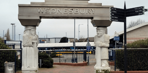
In response to Viking attacks on Mercia. King Alfred’s daughter Aethelfleda and her husband built defended settlements or burghs across Mercia, one of which is reputed to be at Wednesbury (23). However no hard evidence of an early fortification has been found at Wednesbury- but this hasn’t stopped the council from erecting a statue of Aethelfleda at the entrance to Wednesbury bus station – see the header to this blog.
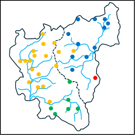
The Conquest and Domesday (1066 – 1086 AD)
When we come to the Domesday survey, we have for the first time detailed information about our study area. Domesday lists 38 manors in our area and these are shown in figure 6 – from the excellent compilation of (24). The colours in this figure indicate the administrative region in which the manors fall – yellow for Seisdon Hundred in Staffordshire, blue for Offlow Hundred, again in Staffordshire, green for Client Hundred in Worcestershire and blue for an entry in Northamptonshire Domesday. It can be seen that the boundary between Seidon and Offlow hundreds basically follow the watershed, although a couple of Seisdon manors (Ettingshall and Bilston) fall into the Tame catchment. The boundary between Client is Worcestershire is along the Stour as would be expected from the Diocesan and County boundaries, with Dudley to the north. The Northamptonshire entry is for (West) Bromwich – which seems to have been included by mistake with its Lord’s entries in that county.
Figure 6. The Domesday manors
The Domesday book also contains much factual information about each manor. However, as all who use this information will know, the details need to be treated with some circumspection. It was compiled from oral evidence by many different people and there are many inconsistencies in the way the data was collected and is presented. This is particularly true of the numerical data for the hidage (originally a measure of area, but by the time of Domesday also a fiscal assessment), the number of ploughlands (the area that could be cultivated by one person) and the number of plough teams. There is however more consistency in the information about Lordship in 1066 and 1086, and the number of workers in various categories (25), and this information is shown in table 1 below. This shows the number of workers in each manor in 1086, in the following categories.
Free men with on average about 30 acres of land and two plough oxen;
Villagers of Villeins, unfree and bound to the Lord but with similar holdings to Free Men;
Smallholders of Bordars, unfree with about 5 acres of land and use of the communal plough team;
Cottagers, unfree with very meagre land holdings;
Slaves, owned by the Lord;
Priests.
The Lords in 1066 and 1086 are also given. The manors are ranked in terms of total number of workers. This order is perhaps surprising to modern eyes. Of the major modern industrial towns in the area, only Wolverhampton is near the top of the list in terms of population. The others – Wednesbury, Dudley, West Bromwich, trail behind, and one, Walsall, is simply not present in the list. The major centres in the area at Domesday were Sedgely, on the watershed between catchments, and Halesowen to the south. Many of the manors had very few workers of any sort. Of those workers the Villagers were the most common, accounting for 56% of the total, which is in line with the larger English picture. 11% of the population were slaves – a perhaps somewhat shocking statistic to modern eyes – with the major concentrations in Halesowen, Wolverhampton and Wombourne. The number of priests is small at 6, and one suspects must be an underestimate. The overall number of workers is 580. Allowing for a household size of 5, which seems a reasonable assumption, gives a total population somewhere around 3000. Even if the Domesday survey omits sections of the population, or if the assumed average household number is too small by a large factor, the population is tiny in comparison to the current population of the Black Country boroughs, which is something over 1 million.
The effect of the Norman conquest on land ownership is starkly clear. In 1066, the major Lords were King Edward with 11 manors, the Canons of St Mary’s Wolverhampton (now St Peter’s) with 5, and Countess Godiva with 3. There were 14 other Lords. By 1086, the number of Lords had been reduced to four. In the main the lands of King Edward had passed to King William; the Canons of Wolverhampton had retained their manors (although one suspects that by then the body of Canons had been thoroughly Normanised) and the Bishops of Chester had retained their single manor. The rest were now under the Lordship of William Fitz Ansculf, who held 98 manors in total across the country, centred on his castle at Dudley. As elsewhere in England, we see how revolutionary and far reaching the Norman takeover was.
Free
Villagers
Small holders
Slave
Priests
Total
Lord in 1066
Lord in 1086
Halesowen
4(a)
42
23
10
2
77
Wulfwin
Earl Roger
Sedgley
45
2
3
1
51
Earl Algar
William Fitz Ansculf
Wolverhampton
6
30
14
50
W’ton St Mary
W’ton St Mary
Bloxwich
16
11
1
28
King Edward
King William
Shelfield
16
11
1
28
King Edward
King William
Wednesbury
16
11
1
28
King Edward
King William
Wombourne
14
3
8
1
26
Thorsten
William Fitz Ansculf
Bushbury
15
2
2
19
Countess Godiva
William Fitz Ansculf
Crockington
14
4
1
19
King Edward
King William
Essington
15
2
2
19
Countess Godiva
William Fitz Ansculf
Kingswinford
14
4
1
19
King Edward
King William
Swinford
5
11
2
1
19
Wulfwin
William Fitz Ansculf
Pedmore
3
10
4
1
18
Thorger
William Fitz Ansculf
Cradley
4
11
15
Wigar
William Fitz Ansculf
Dudley
1
3
10
2
15
Earl Edwin
William Fitz Ansculf
(West) Bromwich
10
3
13
Brictwin
William Fitz Ansculf
Ettingshall
9
3
12
Thorsten
William Fitz Ansculf
Wednesfield
6
6
12
W’ton St Mary
W’ton St Mary
Bilston
8
3
11
King Edward
William Fitz Ansculf
Himley
8
3
11
Ravenkel; Wulfstan
William Fitz Ansculf
Orton
7
2
2
11
Wulfstan
William Fitz Ansculf
Upper Penn
8
2
1
11
Earl Algar
William Fitz Ansculf
Trysull
4
1
5
10
Thorgot
William Fitz Ansculf
Rushall
6
2
8
Vithfari
William Fitz Ansculf
Willenhall
5
3
8
King Edward
King William
Amblecote
4
2
1
7
Earl Agar
William Fitz Ansculf
Compton
4
3
7
King Edward
King William
Tettenhall
4
3
7
King Edward
King William
Lower Penn
1
6
6
Countess Godiva
William Fitz Ansculf
Lutley
2
1
2
5
W’ton St Mary
W’ton St Mary
Bradley
4
4
Untan
William Fitz Ansculf
Oxley
4
4
Alric; Godwin.
William Fitz Ansculf
Seisdon
2
2
King Edward
William Fitz Ansculf
Bescot
0
King Edward
King William
Chasepool
0
William Fitz Ansculf
Haswic
0
W’ton St Mary
W’ton St Mary
Pelsall
0
W’ton St Mary
W’ton St Mary
Tipton (b)
+Chester
+Chester
Totals
6
327
182
65
6
580
Table 1 Domesday manors from (24). ( a- Specified as Riders , b- Part of the Bishop of Chester / Lichfield manor. Breakdown of workers not given. )
A look beyond Domesday
Before closing, there is perhaps one further point that is worth raising. Ultimately it was the geological wealth of the area that resulted in its transformation in the eighteenth and nineteenth centuries, and specifically its coal reserves. But the coal didn’t suddenly appear in that era – it was there all the time and in many places there were surface outcrops. The locations of these are shown from the Coal Authority web site (26). It is very likely that these resources were exploited on a small scale from the Roman period onwards. The major transformation of the area came in the last few hundred years, but the seeds of that transformation were being sown well before Domesday.
Figure 7 Coal outcrops from (26).
References
Dilworth D (1973) “West Bromwich before the Industrial Revolution”, Black Country Society ISBN 0 9501197 9 2
Green C (2020) “Britons and Anglo-Saxons: Lincolnshire AD 400–650”, Studies in the History of Lincolnshire, History of Lincolnshire Committee ISBN 0902668269
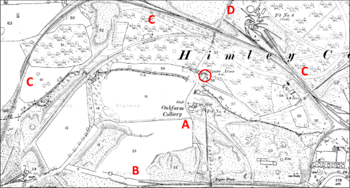
In the aftermath of the dreadful events at the Crooked House (or Glynne Arms) in August 2023 (the timeline of which I have documented here) my interests in the Oak Farm area were rekindled., and I wrote a blog post on the early history of the Glynne Arms that has been quite widely read. Perhaps the main insight to emerge from that post was to restate the often-missed fact that the Crooked House began life as a corn mill on the Oak Farm Estate owned by Stephen Glynne and evolved into a public house in parallel with the rapid industrialization of the estate in the 1840s and 1850s. This point was also made in a blog on the Black country Society site by Steve Roughton, who indeed argued that it was the existence of soft ground around the mill race that caused the building to tilt. The Oak Farm Mill stood on the Himley Brook on the boundary between Kingswinford and Himley parishes, and was powered by water from the brook, stored in a mill pool to the east and released into a mill race before rejoining the brook some way to the west. It was not the only mill in the area. To the east (i.e. upstream) the Himley Brook was joined by the Straits Brook, that formed the boundary between Himley and Sedgley parishes. Just upstream of the confluence, the waters of the Straits Brook were stored in a large mill pond that operated the Coppice Mill, owned by the Dudley Estate. This mill pond extended north to beyond Askew Bridge on the road from Himley to Dudley and is named in some sources as Furnace Pool – allegedly the site of one of Dud Dudley’s experimental furnaces in the 1620s – and the water was used to power the furnace bellows.
In this blog post, we look specifically at the watercourses that supplied the two mills, and how it evolved through the decades. It will be seen that it leads to some speculations that, in the 1840s the original Oak Farm Mill was much modified, and perhaps moved, taking water from the upstream Coppice Mill pool rather than its own. It also suggest that the Crooked House as we knew it up to August 2023 dates from that period.
Mills and watwerwheels
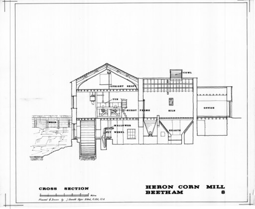
Firstly, however, we need to consider the nature of the mill itself, and in particular the possible waterwheels that were installed. Wikipedia gives a useful article on this. Basically, there are two types of wheel (although with many variants) – overshot and undershot (see Figure 1). Both of these require a differential height (or head) of water – from a reservoir of mill pool upstream, to a mill race downstream. For overshot wheels, the water fills buckets on the wheel circumference and the potential energy in the water is transferred into rotational energy in the wheel. For undershot weirs, the fall of the water upstream of the wheel decreases its potential energy and increases its kinetic energy (and thus its velocity), some of which is transferred to rotational energy in the wheel when it impinges on the vanes. A simple analysis indicates that the power output of both types of wheel is proportional to this height difference raised to the power of 1.5. Of course, the greater the head, the larger the wheel would need to be to extract the power, and the greater the mechanical challenge. The power from the wheel would have been suitably transmitted through gears to grindstones to produce flour from the cereal grains (see Figure 2 for an example from Cumbria). The miller of course would like to have a long period of operation of the wheel, but as water is released to the wheel, the level of the upstream mill pool will fall and the head available and hence wheel power will also fall. At some point the water level will fall below the level of the outlet weir or pipe in the reservoir. Thus, there is an advantage in having a large reservoir from which large quantities of water can be abstracted without too great a fall in the water level. There is no indication which type of wheel was present at the Glynne Arms.
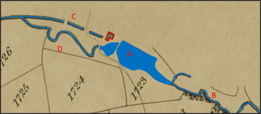
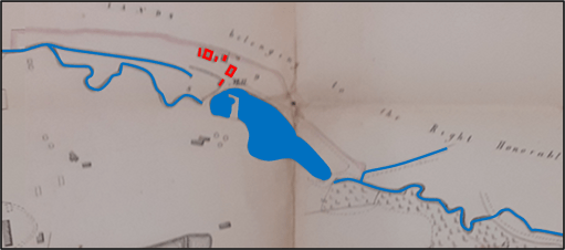
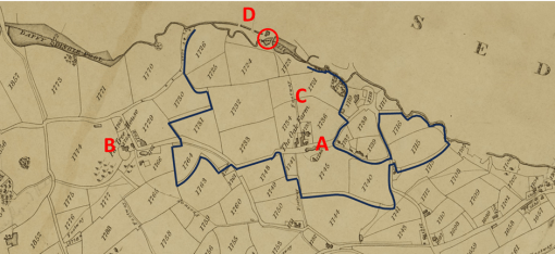
Moving on now to consider the development of the Mill and its watercourses, we will use a number of maps from a variety of sources. Each of the maps represents the same geographical area, and the buildings of the Mill / Glynne Arms are outlined in red, and the watercourses highlighted in blue. In their original forms, some of the maps did not have north at the top in the normal way, so these have been rotated, but the orientation can only be regarded as approximate. Figure 3 is an extract from the 1822 Fowler map of Kingswinford parish. The Oak Farm Mill was just outside the parish, so its appearance on the map is perhaps fortuitous. It is depicted as a simple L shaped building. The mill pool (A) is fed by the Himley Brook to the east (B) and itself feeds both the mill race (C) and the downstream channel of the brook (D). C and D join again at a point downstream. Water would have been diverted along the mill race by a system of sluices when the mill was in operation. The line of the mill race passes under the southern end of the building, which indicates that the mill wheel is at the southern end of the building. The parish boundary is defined by the brook and passes through the centre of the mill pool. The Oak Farm estate was wholly agricultural at this time. As this is a map of Kingswinford parish, nothing is shown of the area to the north of the mill in Himley parish.
Figure 4, from the Kingswinford Tithe map, surveyed in 1839, shows a very similar situation. The Oak Farm Mill is however indicated by a simple rectangular structure over the line of the mill race.
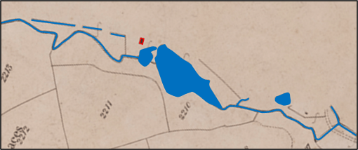
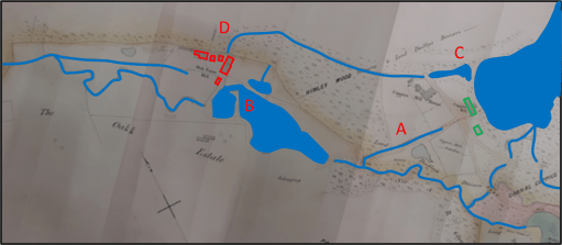
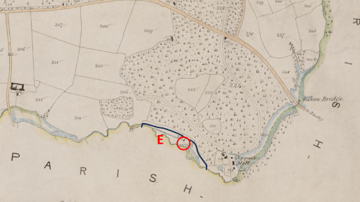
The map of Figure 5 is an extract from a document that was clearly drawn for the owners of the Oak Farm Estate and is dated November 1840. This map was used by Steve Roughton in his blog mentioned above, and I am grateful for his permission to use it here. He originally obtained it from the Clwyd archives many years ago, presumably amongst the Glynne papers relating to their home in North Wales. I have to admit that this is not a place I would have considered looking for details of the Crooked House. This shows a similar situation, with rather more detail of the watercourses to the east (i.e. upstream) and to the north (in Himley parish). In particular the buildings of Coppice Mill (A) are shown in green, with a channel leading from their vicinity into the Himley brook at the top of the Oak Farm Mill pool. The Coppice Mill pool was to the east of the mill buildings and is not shown The Oak Farm Mill itself is now represented by three distinct buildings, which suggests that the simple rectangular form in Figure 4 might be a schematic rather than realistic representation. On the other hand it suggest that the two northern buildings might have been constructed around that period. The line of the mill race (B) passes to the south of the most southerly building suggesting that the waterwheel was on the south of that building. Mine shafts of Oak Farm Colliery can be seen to the south of the brook near the downstream end of the Oak Farm Mill pool (C).
Figure 6, dating from sometime in 1841, is an extract from the Himley Tithe map. It can be seen that there have been some changes. The channel from Coppice Mill pool seems to have been replaced by one leaving the Coppice Mill pool at the north western corner (A), presumably connecting by an underground sough to the new pool on the north side of the Oak Mill pool (B). Alternatively these channels might simply represent construction phase of the new watercourse system that will be described below. This channel is distant from the Coppice Mill buildings and suggests that it is not intended as a channel to feed the mill, but rather to act as an overflow to the Coppice Mill pool, or to increase the flow to the Oak Farm Mill pool. There is perhaps an indication on Figure 6 of a channel corresponding to the mill race position (C), but this is not totally clear. The Oak Farm Mill is again shown by a simple rectangular building – again probably a simple schematic representation.
Figure 7 is an extract from a map that can be firmly dated to April 1849 that shows the whole Oak Farm Estate and may have been produced for when the Estate went on the market in that year. Is shows a similar situation to Figure 6 from 1841, although the shape of the mill pool is different and the small pool to the north no longer appears (perhaps because this wasn’t part of the Estate). The different buildings of the Corn Mill complex are individually shown.
Figure 7. Extract from Oak Farm Estate map of April 1849
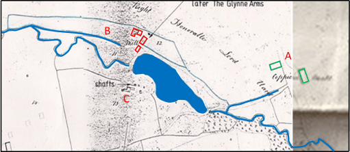
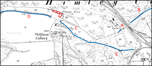
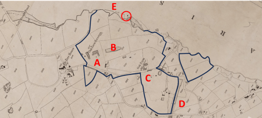
Figure 8, produced for the Dudley Estate, has notes referring to the removal of some trees in 1849 and can probably be dated soon after that, perhaps the early 1850s, as the mill pool shape is similar to that of Figure 7.. The Coppice Mill race is clearer (A), and there have been some changes to the shape of the Oak Farm Mill pool (B). The major change, however, has been to the channel from the northern corner of Coppice Mill pool (C) which has now been extended as a surface channel with a sharp turn to approach Oak Farm Mill from a northerly direction (D). This looks to be a new mill race, bringing water from the higher Coppice Mill pool to the Oak Fame mill, which is here shown as a number of separate buildings, with the original mill building to the south. The change in direction would either have meant a complete rebuild of the original mill building to accommodate a new water wheel on its western side, or perhaps the relocation of the mill to the building to the north (the later public house) with a new mill wheel on its western side.
Figure 8. Oak Farm and Coppice Mills in the early 1850s
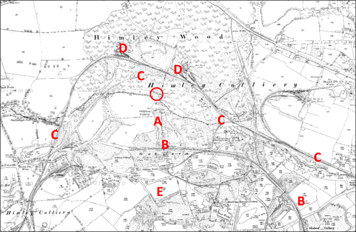
Figure 9 is the Ordnance Survey map of 1882. The situation can be seen to have changed completely with the topography being much changed by mining and other industrial activities and the development of the railway network. The Coppice Mill buildings (A) , and the Coppice Mill pool no longer exists (B), although there is a stream running through its location that runs underground to a junction with Himley Brook. In place of the mill there is a branch of the Earl of Dudley’s railway. Similarly, the Oak Mill pool is now longer visible (C), and the Himley Brook has been channeled, and west of the Oak Farm Mill (now named the Glynne Arms) runs along the old Oak Farm Mill race (D). The eastern end of the Himley brook now presumably runs underground (E). The original (southern) Oak Fam Mill building is no longer visible.
The 1882 situation is mirrored on the current Ordnance Survey map (Figure 10) and satellite view (Figure 11), where no trace of the mills and mill pools can be seen.
The main implication from the above discussion is that it is likely that, around 1841, significant works were carried out on the watercourses in the area, so that Oak Farm Mill was supplied with water from the Coppice Mill pool rather than its own mill pool. The reason for this was straightforward – this would have given a greater head of water, and thus enabled the waterwheel to produce more power for the process of corn grinding. In addition, the larger area of the Coppice Mill pool would have allowed for longer periods of water wheel operation. As there has been much change in the local topography since then due to mining and other activities, it is difficult to be precise about the magnitude of this increase in power, but an estimate can be made from the ground level heights obtained from, for example, Google Earth. The current ground level downstream of the Glynne Arms is around 84m above sea level (asl). Just upstream, in the region where the Oak Farm pool used to be, the current ground level is around 88m asl. At the site of the Coppice Mill the ground level is around 90m asl. The Coppice Mill pool extended beyond Askew Bridge on the road from Himley to Dudley. The ground level on either side of the bridge is around 98m, with the stream under the bridge a metre or so lower. There is thus a very considerable slope from Askew Bridge down to the Glynne Arms – which is of course the reason why two mills were built there. From these heights we can estimate the following.
Water level in race at Oak Farm Mill 84m
Water level in Oak Fame Mill reservoir 88m
Water level in race at Coppice Mill 90m
Water level in Coppice Mill pool 96m
Thus, the head of water available to the Oak Farm Mill was around 4m, and to Coppice Mill was around 6m. The full benefit of these heads would not be available because of head losses in pipes, and sluices etc, but we can estimate the available heads would be around 2m and 4m. Now if the waters in Coppice Mill pool were used to operate the Oak Farm Mill, the potential head available would be 12m. Much of this will be lost by the passage along the new millrace, but it would still be substantial – perhaps around 4m. This represents a doubling of the head available to the Oak Farm Mill, and, as the power is proportion to the available head to the power of 1.5, an increase in power of almost three times. Of course, a considerably bigger water wheel would have been needed to extract this power.
The provision of the Coppice Mill pool water to Oak Farm mill resulted in a ninety degree change in the direction from which the water was coming. As noted above this would either require a major change in the original mill building (the building at the south end of the building complex shown in Figure 8) to accommodate the change of direction and the installation of a larger wheel, or perhaps the construction of a new wheel on the western side of the main building (what was to become the Glynne Arms). Adding speculation to speculation, depending on the type of wheel that was used, this wheel might have rotated in a clockwise direction looking from the west. Now Steve Roughton hypothesized that the main reason for the tilt on the Glynne Arms was due to the soft ground around the original mill raise to the south of the main building. It may thus be that the moment caused by any new waterwheel on the building would have been in the direction to encourage this tilt.
Finally, some further speculation. The early maps show the Oak Farm Mill as a simple rectangular or L shaped building lying to the south of the final location of the Glynne Arms. The current building does not appear on maps in a recognizable form till the 1840s. Thus it may be that the Glynne Arms building was constructed at this period, possibly as a replacement mill when the watercourses were modified. Certainly in the 1841 census, the occupier of the property, John Cartwright was referred to as a farmer, miller and beer house keeper, so the Oak Farm Mill buildings also served as a beer house. That being said, a number of sources give the date of the building of the Glynne Arms as a farmhouse as 1765 – although I do not know the primary source of that date. I suspect it refers to the date when the original mill was constructed.
Whether or not the speculation above has any merit, it is nonetheless clear that in the early 1850s, major construction work was carried out to increase the supply of water to the Oak Farm Mill, but that the new water courses were all swept away as heavy industry spread across the area in the later 1850s and 1860s.
This is the first of two blog posts that set out a timeline of the destruction by fire and subsequent demolition of the Crooked House in Himley in early August 2023, through links to local and national press reports. This blog covers the period up to December 2023. Later reports can be found in the second blog post here.
In the days after the fire, there were many, very similar, press reports and thus there has been a need to be selective. In what follows, I thus use three main sources.
BBC local and national news websites, which was, and continues to be, the most comprehensive source.
The Express and Star website, which gives a local perspective. Note that many of the articles that are linked require free registration to be read.
The Guardian website – although many national newspapers reported the story in early August, the Guardian’s was probably the most comprehensive and, through its columnists, the most reflective.
I also include articles from other sources where they complement the above, including a few from overseas to demonstrate the reach of the story. I will update this list at intervals over the coming months.
In addition to the news links, there are two Facebook pages that contain news and (often robust) comments covering a range of opinion.
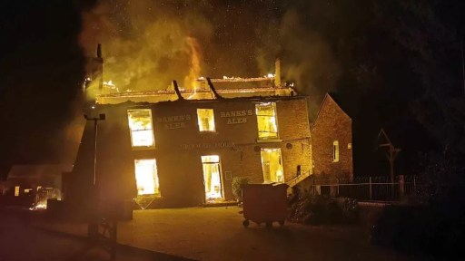
The recent burning down and demolition of the Crooked House public house in Himley in August 2023 has made news both nationally and internationally, and there are ongoing police investigations into the events and a vociferous campaign for rebuilding. In all the reporting, however, there has only been limited discussion of the history of the Glynne Arms, as it was formerly known. It is the intention of this post to fill in this gap, in terms of the early history of the property, up to around 1880. I feel this is important, as it gives something of the background and context that is perhaps somewhat lacking in the current conversations.
Figure 1 shows a modern Ordnance Survey map of the area. The Crooked House is indicated by a red circle on this figure and the ones that follow, which, unless otherwise stated, all show the same area to the same scale. The site of the Crooked House is situated on the north bank of the Himley Brook that flows east to west from the Old Park / Russell’s Hall area to the River Smestow, at the end of a mile long lane that leaves the Himley to Dudley Road just to the east of Askew Bridge (A). Footpaths from the site go north through Himley Wood (B), and south across an area of reclaimed industrial land (C) and the old GWR Kingswinford branch line (D) to Oak Lane (E), where there are various small-scale industrial businesses. But the area that we see now is very different from how it would have looked a hundred years ago, which itself was very different from how it would have looked a hundred years before.
Figure 1. Location of the Crooked House on a modern Ordnance Survey map
The Crooked House was built in 1765, probably as a corn mill, and first appears in the records on the 1822 Fowler map of Kingswinford parish (figure 2). The Himley Brook was the boundary between the parishes of Kingswinford and Himley, and the Crooked House, being to the north of the brook, was in Himley Parish, and thus its appearance on the Kingswinford map is quite fortuitous. At the time it was part of the Oak Farm Estate owned by Lady Mary Glynne of Hawarden in north Wales, that had been bequeathed to her and her husband by her father on her marriage to Rev Stephen Glynne in 1779 (Davies R (1983) “The Great Oak Farm smash”, Blackcountryman 16.3, 18). The estate consisted of around 90 acres of farming land mainly in the north of Kingswinford parish, with small areas in Himley and Sedgely parishes. The names of the fields give an indication of its rural character – for example Barn Close, Coppice Piece and Ox Ley. The land to the north of the Crooked House was part of the Dudley Estate and was a mixture of arable and coppiced woodland. The figure shows the boundary of the estate, Oak Farm itself (A), Fir Tree House outside the estate owned by Lord Dudley (B) and the footway from Oak Farm to the Crooked House (C). At the time, the Oak Farm estate was largely farmed by Richard Westwood, who lived at the Oak Farm. The Crooked House was at this stage, clearly a mill, and the mill race can be seen on the map passing beneath the house (D). There would have been a waterwheel operated by the water from the pool on the Himley Brook to the east, with the water being returned to the brook along the mill race. The road network at that time was very different from the modern network, although Stallins Lane and its predecessor can be seen in the bottom right-hand corners of both figures 1 and 2.
Figure 2. The Crooked House on the 1822 Fowler map of Kingswinford Parish
The next occurrence of the Crooked House in the historical record comes from the Tithe Apportionment records and maps in the early 1840s. The maps for Kingswinford and Himley parishes are shown in figures 3a and 3b. Note that the alignment to north is not quite consistent between the maps – the originals of both were aligned in somewhat arbitrary directions and alignment was not straightforward. In some ways the situation was very similar, with the surrounding countryside still very rural. But change was underway. The Oak Farm estate had passed to Lady Glyne’s son, Sir Stephen Glynne and in 1835 he and his partners had begun to exploit the large reserves of coal, ironstone and clay that had been found there. In the tithe allocation the estate is said to be owned by the Oak Farm Colliery Company, with the owners of the company being Thomas Bagnall, James Boydell, Baronet Sir Stephen Glynn, John Hignett, William Hignett and Charles Townshend. Already there were the Oak Farm furnaces to the south of Himley Brook (A and B), together with at least three coal pits and three ironstone pits and the associated pumping engines (C). The northern end of the Stourbridge Extension Canal can be seen on Figure 3b (D). The boundary of the estate is also shown and, whilst it remains substantially the same as in 1822, there have been some changes in the region of the Extension Canal. The somewhat reduced area of arable land (57 acres) was farmed by several tenants, with the majority (50 acres) by John Cartwright who was based at the Crooked House. In the 1841 census, his age is given as 62 and he is described as a miller, farmer and beer shop keeper. He was living with his wife Sally, aged 56, and three domestic servants. The mill race can again be seen on both maps (E). Again, the road network can be seen to be different to the current network, with the current long lane to the Crooked House not appearing.
a) Himley Tithe map
b) Kingswinford Tithe map
Figure 3. The Crooked House on the Kingswinford tithe map and the Himley tithe map
The fate of the Oak Farm company is well documented elsewhere – there seems to have been a major lack of financial control, probably to an over rapid expansion by James Boydell, who was in charge of the management of the company, that led to a level of debt that could not be serviced. The firm went bankrupt in 1849, and all its very considerable effects were put up for sale. This included
…. that conveniently situated and commodious dwelling-house, now used as a Public-house, with the garden, stabling, outbuildings and appurtenances, and water corn mill, now in the occupation of Mr. John Cartwright……
The whole estate was eventually bought by the future prime minister William Gladstone, Stephen Glynne’s brother, Stephen Glynne himself and his brother Rev Henry Glynne. It took many years, and a great deal of money, for Gladstone to resolve the financial issues of the Oak Farm concern and the other Glynne Estates, but the Oak Farm works began to prosper. However, by the 1860s and 1870s the mineral resources in the Oak Farm area were beginning to fail, and on the death of Sir Stephen in 1874, the family finally sold the estate.
During this period, the Crooked House no doubt continued as a corn mill whilst there was any arable land left to produce grain, but also came to serve the coal miners and iron workers of the area. In the 1851 census, it is simply referred to as Himley Oak Farm Mill, run by Sally Cartwright, aged 66, John’s widow, who also farmed 30 acres (note the reduction from 1840). Her son Joseph (aged 26) was the miller. It is interesting to note that Sally sister, Fanny Amis, aged 74, also lived with them. In the Directory to the Fowler map of 1822 she is recorded as being responsible for the Hollies Farm in the Old Park / Russell’s Hall area.
During the period of the Oak Farm concern rise and fall, the area around the Glynne Arms changed out of all recognition. Figure 4a shows the Ordnance Survey map of 1881 to the same scale as figures 1 to 3, whilst figure 4b shows the area around the Glynne Arms to a rather larger scale. The area to the south of Himley Brook had been extensively mined and the map shows the location of the Oak Farm Colliery and large areas of colliery waste (A). And the pub now seems to be surrounded by railway lines – the GWR Kingswinford branch to the south (B), at this time terminating in the Oak Farm area, and the complex tangle of lines of the Earl of Dudley’s Pensnett railway to the east, north and west (C). There are extensive railway sidings and collieries within Himley Wood itself (D). Very little undisturbed land remains. The mill pool has been drained, and the Himley Brook diverted, possibly along the mill race. A comparison of figures 1 and 4 does however show that the road network is approaching its final form and route of Oak Lane is very similar to the present and the long lane from the Himley Road to the Glynne Arms can also be seen, at least in part (E). The access still seems to be from the south however, showing that it was very much part of the Oak Farm estate.
(a)
(b)
Figure 4. The Crooked House on the 1881 Ordnance Survey map
Figure 5 is taken from the Coal Authority web site and shows the mine entries that have been documented around the Crooked House. The cluster to the south of the Himley Brook (A) were part of the Oak Farm Collier and were in use from the 1860s to 1880s, and if mining subsidence caused the Crooked House to take on its iconic character before its destruction, the mines in this area are the cause.
Figure 5 Mine entries in the area of the Crooked House
In conclusion then, it is clear that the early history of the Glynne Arms / Crooked House was bound up with the development and tribulations of the Oak Farm Estate, and there was a gradual transition from its role as a Corn Mill to that of a Public House. It may be that, should the remaining foundations of the Crooked House ever be investigated as part of any rebuilding that some interesting archaeological remains might be found, pertaining to the corn mill (perhaps the wheel pit or supports, and remains of the mill race).
The area known as the Black Country was of course originally rural in character and consisted of fields and woodlands with scattered settlements. However, in the area that lay on the Staffordshire coal field there was ultimately very little land that was left untouched by the direct activities of coal mining and its associated larger areas of spoil, or by the industries that relied on the coal. Coupled with the massive housing developments of recent years, nearly all the rural land in the mining areas of the conurbation has long since disappeared. This is illustrated in the Ordnance Survey Map for the Kingswinford / Pensnett area at the western edge of the Black Country in Figure 1, where there is very little open space to be seen, and what there is, is almost always “made ground” – landscaped former waste and industrial areas.
In this post however I want to draw attention to one small area of land that seems to have escaped the ravages of mining and industry and sustained its agricultural / green space nature into the present. This is contained within the black rectangle of Figure 1 – the are on which currently the Pens Meadow School sits, along with its associated playing fields. We will illustrate this through the use of maps from 1822 to the current day, and on the way draw out some other interesting aspects of this very small area of the Black Country – a sort of micro-history of a very limited area.
Figure 1. The Kingswinford / Pensnett area 2023
The 1822 and 1840 Fowler Maps
Figure 2. The 1822 Fowler Map
We begin with a map from 1822 in Figure 2 – an extract from the map of Kingswinford parish produced by the firm of William Fowler about which I have written elsewhere. The location of this extract with regard to the wider area is shown by the black rectangle in Figure 1. It basically shows the area to the west of Tiled House Lane and Bromley, both of which are indicated in red. In what follows we will concentrate on the three fields with names shown in green –Upper Wharrs (almost 9 acres); Lower Wharrs (6 acres) and The Hilly Close (3 acres). These were all part of the Tiled House Estate which ran from Commonside to the east, down the south side of Tiled House Lane and extended westward as far as the Standhills area, and southwards as far as Bromley Lane. See here for more information on this Estate. At the time it was owned by the Trustees of the Late Richard Mee, and was suffering from severe financial difficulties. The Wharrs were rented out to Thomas Brettell for farming, and the Hilly Close to James Mullet for similar purposes. Whist the name of The Hilly Close is self-explanatory (it was actually on a region of slightly higher ground than the surroundings), the name of Wharrs is not familiar to modern ears. It’s meaning is something like “land where willows grow” – and thus could be expected to be somewhat damp. The reason for this can be seen in the bottom left of the figure – the Dawley Brook forms in the bottom of the Lower Wharrs. This drains out to the north beneath the Dudley to Kingswinford Road, through what is now Kingswinford Park and out westwards to the River Smestow. Whilst the map is from 1822, in all likelihood these three fields existed within the 1822 boundaries for several centuries before that. It is certainly the fact that the field boundaries in the Corbyn’s Hall estate to the north were unchanged from 1680 (and probably long before) to 1822.
In what follows, I will try to show in what follows that two of these three named fields – Upper Wharrs and The Hilly Close managed to escape the fate of nearly all the fields in the area of being ravaged by mining and the associated spoil heaps, and the later residential development.
On the map of Figure 2, two other features of interest stand out – The Tiled House itself to the east, the site of late 17th century steel making experiments, and the coloured lines to the west. The latter show the course of the Stourbridge Extension Canal that was built in 1837 and did not exist in 1822. At some point in the map’s history (probably before 1837) someone added these lines to the 1822 map, for the purposes of confusing anyone who should try to read it in the 21st century.
Figure 3. The Fowler Map of 1840 – the Tithe map
Figure 3 shows an extract of the same area from the 1840 Tithe Map of the area, again produced by the firm of William Fowler for the pruposes of allocating tithe rentals. The Stourbridge Extension Canal is shown on the left, with the Standhills branch going off the west. There is also a tramway marked that took the products of the Corbyn’s Hall estate to the canal basin at wide waters. It was built in the late 1820s, but in 1837 was purchased by the canal company and decommissioned. It would have been operated by gravity, as there is a considerable slope from north to south, passing beneath the road at Bromley, presumably with horses used to pull the empty wagons back up the slope. Unfortunately, little other information is available about the tramway – for example the nature of its construction, its gauge, truck size and capacity etc.
But despite these developments, the three field under consideration were not affected. They were still owned by the Mee trustees, and all let out to one Walter Dudley. Lower Wharrs was described as pasture with a tithe rental of 3s 4d, Upper Wharrs as meadow with a rental of 6s, and the Hilly Close as Arable land with a rental of £1 – showing the higher value of arable land in comparison to pasture and meadow.
The 1880 and 1900 Ordnance Survey maps
Figure 4. The Ordnance Survey map from the 1880s
By the time of the first large scale Ordnance Survey map in the 1880s (figure 4) the situation had changed significantly, with industrial activities encroaching on the area. The Great Western Railway Kingswinford branch runs to from south to north to the east of the canal. There are disused mines that encroach on the area of the Lower Wharrs (Tiled House Colliery Pits 17 and 18) and to the south of the Tiled House (Tiled House Colliery Pits 19 and 20) with the New Bromley Colliery still operating to the south of Upper Wharrs and Hilly Close. Both of these fields however retain their former boundaries and were still used for farming. Tiled House Lane takes on its modern shape of an east to west portion down from Commonside, although extended further west that it does currently, and a north south portion to the east of Upper Wharrs toward Bromley, although both parts carry the name of Rookery Lane at this time. Indeed, the top half of the north-south portion follows the line of the old Corbyn’s Hall tramway, the extension of which towards Bromley is still visible on the map.
In the Ordnance Survey map from the 1900s of Figure 5 the situation is similar, although the name of Tiled House Lane is attached to its east to west portion and Rookery Lane to its north to south portion. The southern part of the Lower Wharrs and the other two fields still retain their earlier boundaries.
Figure 5. The Ordnance Survey map from the 1900s
The 1930s and 1960s Ordnance Survey maps
Figure 6. The Ordnance Survey map from the 1930s
Figure 6 shows an Ordnance Survey Map from the 1930s, and there have been significant changes. The Tiled House itself has disappeared, and the Tiled House housing estate in now in existence in its current form. The Pensnett Secondary Modern School has been built, mainly on the Hilly Close, with the southern half of Upper Wharrs as the playing field and the northern half as allotments (behind the houses on Tiled House Lane). The Lane itself has been somewhat straightened out in the process of this development. Nonetheless the combined area of Upper Wharrs and The Hilly Close has retained its integrity and to some degree its agricultural function. The northern half of Lower Wharrs and the area to the south still seems to consist of colliery waste.
One other interesting point to note is that the boundary of the Corbyn’s Hall tramway is marked by the line of the back gardens in the southern cul-de-sac on Tiled House Lane. An archaeological dig in the back gardens of numbers 124 to 130 might well reveal something about the nature of the tramway, but would probably not be much appreciated by the residents. Similarly, the point where the tramway passed underneath Bromley (just outside the current Pensnett / Bromley school entrance) could well retain some evidence of the tramway.
The same situation is illustrated in the aerial view from 1950 shown in figure 7. The view is centred on the Gibbons works on Corbyn’s Hall, but to the top of the picture the outlines of Upper Wharrs and The Hilly Close can be made out, together with both legs of Tiled House Lane.
The situation is very similar in the 1960s map of figure 8, although the area of the allotments has become a playing field area.
Figure 8. The Ordnance Survey map from the 1960s
The present-day situation
Figure 9. The 2023 Ordnance Survey map
Finally, we come to the present-day situation shown in the up-to-date Ordnance Survey map of Figure 9 and the Google areal view of Figure 10. The school has been replaced by a new entity -the Pens Meadow School in The Hilly Close, and the area of the Upper Wharrs is now playing field or car parks. The eastern portion of Lower Wharrs has been incorporated into the field. The waste area in the north of Lower Wharrs has either been developed for housing or been landscaped as a recreational area. The waste area to the south has been treated in the same way, to give a large green space alongside the railway line.
Figure 10. An aerial view of the current situation (from Google maps)
It can thus be seen from these maps it can be seen that the area of Upper Wharrs and the Hilly Close represents a remarkable survival of a “land unit” that, in the main escaped the ravages of mining and waste and has retained, to a large degree, its “green” character. It also suggests that the name of the school currently on the site should either be “Hilly Close school” or perhaps even the “Wharrs school”. I doubt the second would be much appreciated by parents, teachers or children.