The Cross City Line – 1962 to 2024

Introduction

I have been a collector of old bus and railway timetables for many years, with no particular end in view, other than to put them in boxes for some unspecified future use. However, the assembled timetables seem to be too good a resource not to make use of in some way, and I used some of them to compile a recent post on the development of public transport in Oakham in Rutland. This went down surprisingly well with readers, which shows there are some very odd folk out there. But the reception has encouraged me to press ahead with a series of posts that will use my stash of timetables to look at the development of public transport services in particular places or on particular routes. This particular post will consider the development of the Cross City railway line that runs from Lichfield in the north, through Birmingham, to Redditch and Bromsgrove in the south. There is an excellent Wikipedia article that describes the history of the line, and there is little point in reproducing that, and in this post I will concentrate on the development of the timetable on the line from the early 1960s (when it didn’t exist as one route) through to the present. It will be seen that it is in some sense a story of ambition that has never been quite fulfilled because of operational issues.

In what follows we will track this timetable development through the use of timetable extracts – usually for the weekday morning post peak period, but sometimes for other parts of the day where the (lack of) availability of information makes that necessary. This shows the broad outline of the timetable, but cannot of course capture the full detail.

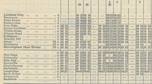
September 1962 to June 1963

North
South

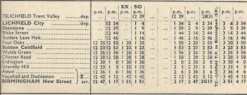
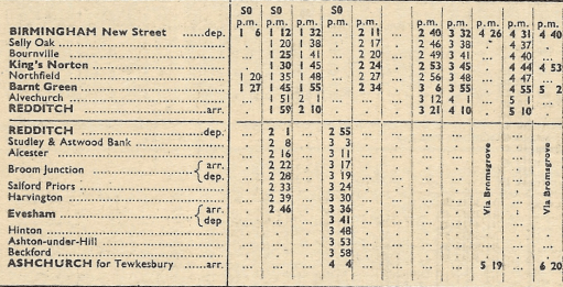
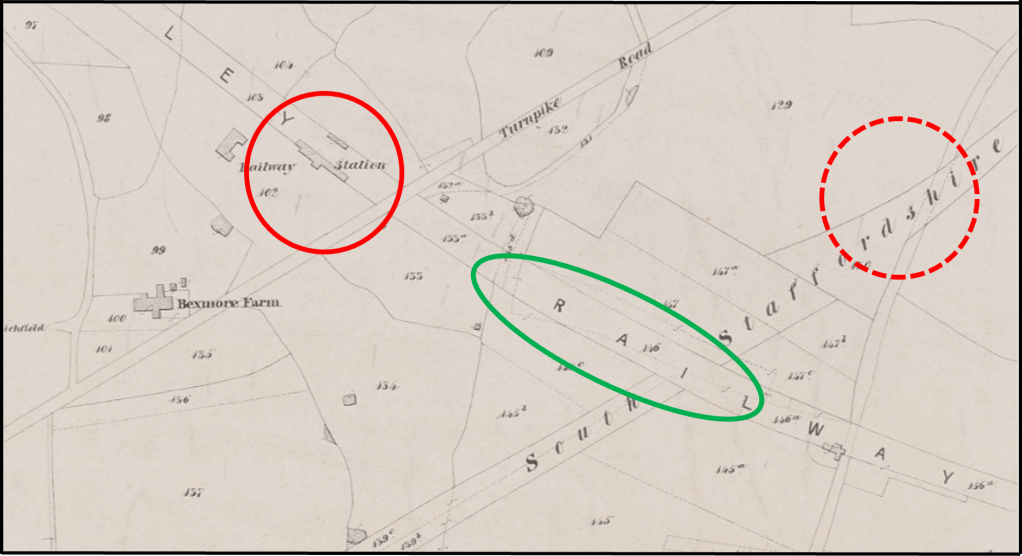
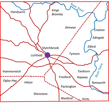
We first of all consider the situation in the early 1960s. Extracts from the timetables for the routes that were ultimately to form part of the Cross City line are shown above, for the early afternoon weekday period (taken from the London Midland Region timetable for September 1962). It can be seen that there is broadly a half hourly service from Lichfield city to Birmingham New Street. Connections are provided to Lichfield Trent Valley (where the current Cross city line crosses the West Coast Main Line) by a Burton on Trent – Lichfield – Walsall service, with occasional through services from Trent Valley to Birmingham. Some trains started and terminated at Four Oaks, but there was no regular pattern. South of New Street, the service to Redditch was somewhat sporadic, with some trains extending to Evesham and Ashchurch for Tewksbury. Note that trains did not at that stage call at Five Ways (which was closed) or University (which didn’t exist).

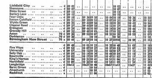
September 1964 to June 1965

North
South

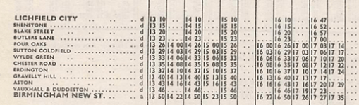
By 1964, the first wave of the Beeching cuts had taken place and the timetables above (again from the London Midland Region timetable) such trains as there were to Redditch from New Street terminated there. North of New Street, the service to Lichfield varied between a thirty minute and an hourly frequency, with hourly trains starting at Four Oaks. Again, there were connections to Lichfield Trent Valley from Lichfield City on the Walsall to Burton service.

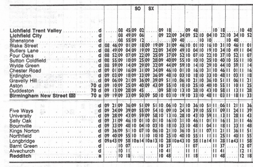
May 1969 to May 1970

North
South

The May 1969 timetable (from the London Midland Region timetable downloaded from Timetable World) shows a more regular service on the north end of the route, with an hourly service from Lichfield City and a thirty minute service from Four Oaks to New Street. South of New Street the trains to Redditch were again somewhat sporadic, with one, two or three hour intervals between them.

May 1978

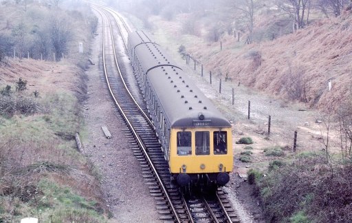
The Cross City line opened in something like its current form in 1978. The graphic above (a screenshot from a rather fuzzy ebay photo) shows that it was marketed as a service between Longbridge and Four Oaks, with a fifteen minute interval service between the stations. There were in fact hourly trains to Lichfield City that were not referred to in the timetable shown, and sporadic trains to Redditch in the south. The route was operated at this stage by Class 116 DMUs. Five Ways station had been re-opened and a new station built at University.

Class 116 DMU

May 1980 to May 1981

The May 1980 service (shown above from the national BR timetable) is similar to the 1978 service. Here the extract shows no services to Redditch although there were again some sporadic, mainly peak hour services down the Redditch branch.

May 1983 to May 1984

By May 1983 the situation to the south had become more satisfactory with hourly trains to Redditch, with Lichfield City also having hourly trains, and four an hour from Four Oaks to Longbridge.

May 1984 to May 1985

One year further on, in May 1984, the situation is again similar, but with one of the Four Oaks trains per hour extended to and from Blake street.

July to September 1991

By 1991 there were significant changes. Two trains per hour ran south from Lichfield Trent Valley (which had been reopened in 1988), four trains per hour from Lichfield City with some peak services running from Blake Street.. To the south there were four trains per hour to Longbridge, two of which were extended to Redditch.

September to November 1992

The BR national timetable showed that the situation in September 1992 was very similar to the previous year, but was only timetable to extend to the end of November 1992, when a different timetable came into operation (see below).

December 1992 to May 1993

The December to May 1993 timetable is very odd, with the services being split at New Street, with four trains per hour from Lichfield Trent Valley to Birmingham, and four to Longbridge, with two extended to Redditch. There is no rationale given for this but may well have been something to do with the electrification works that were going on at the time.

June to September 1997

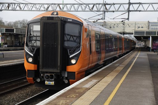
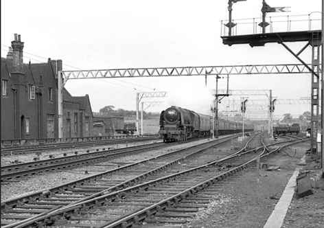
My more intimate involvement with the Cross city line began in 1997/8 when I began working at the University of Birmingham, whilst living in Lichfield, and travelling on the line daily. I thus began collecting the Cross City pocket timetables at this point. It will be seen below that the art work / size / format changed continually over the years that were to follow. The route had been electrified in 1993 and was thereafter, until 2024 operated by Class 323 EMUs, up until 2020 in mainly three car formation, with some six car trains at peak times. The situation was similar to the early 1990s with four train per hour frequency between Lichfield City and Longbridge , with two trains per hour extended to both Redditch and Lichfield Trent Valley.

Class 323 EMU

June to September 2002

In the summer of 2002 we have a very similar looking timetable and frequency, albeit with some slight changes of times. But in general we can see the timetable pattern has remained stable over at least five years.

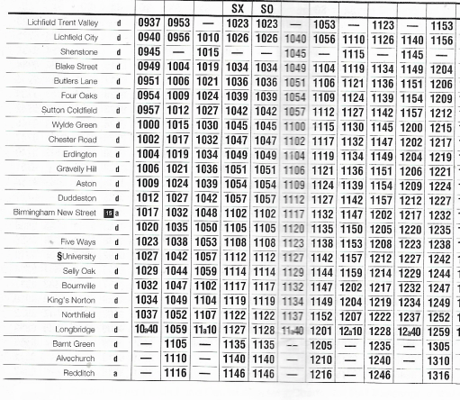
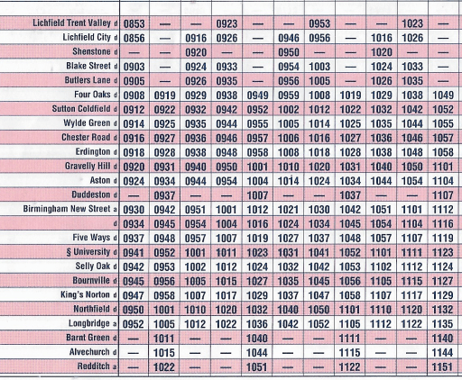
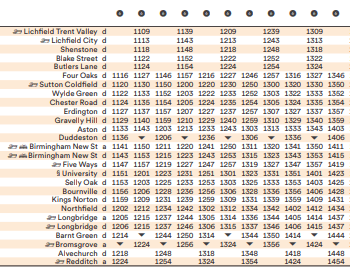
September 2002 to January 2003

In September 2002, there was something of a revolution. The number of trains was increased to six per hour, with four beginning their journeys at Lichfield Trent Valley, and two at Lichfield City and four ending their journeys at Longbridge and two at Redditch. The stopping pattern was complex with not all trains stopping at all stations. To try to make life easier for passengers, trains were to carry a headcode (that can be seen on the above timetable) indicating their destination and the stopping pattern. To put it bluntly, the service was an absolute disaster. A very frequent service with variable stops needs to be highly reliable – and that has never been the case for the Cross City line, largely due to congestion at New Street. My memory is of confused and angry passengers, very late running and many cancelled trains. Although the ambition was laudable, the pattern was never going to work. My memory is that it was replace by an emergency timetable within only a few weeks of its implementation, but I can’t be certain about that. At any rate, a new timetable was issued from January 2003.
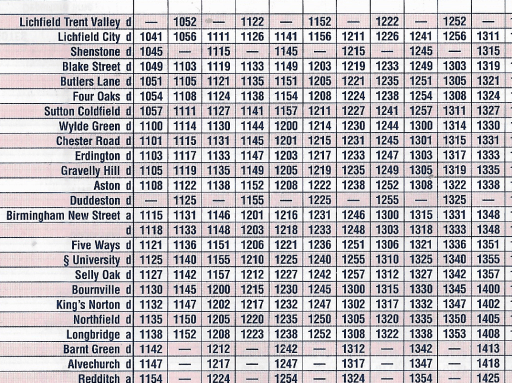
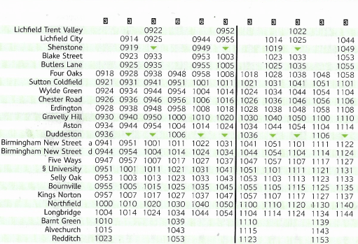
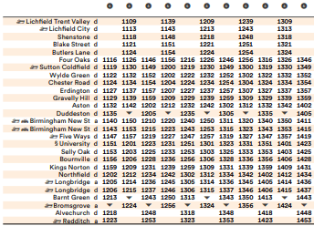
January to May 2003

The new timetable again had six trains an hour, two beginning at Trent Valley, two at Lichfield City and two at Four Oaks, with four an hour terminating at Longbridge and two at Redditch. With only minor exceptions (Shenstone and Duddeston), all trains stopped at all stations. From a personal perspective, this led to an unbalanced departure schedule at Lichfield City, with twenty and ten minute intervals, but this pattern was to persist, in essentially the same form until 2018.

May to December 2009

The 2009 timetable is very similar to that from 2003, with very minor changes of timing.

May 2015

Similarly the 2015 timetable was of the same form, but Redditch was now served by three trains per hour following the opening of a passing loop at Alvechurch that increased the capacity of the branch.

May to December 2019

The main change in 2019 was the extension of two of the three services that terminated at Longbridge to Bromsgrove, following electrification of the line through Barnt Green, with some other slight timing modifications. Then in 2020 COVID happened.

May to December 2022

During the COVID lockdown, the services on the cross city line were scaled back to four per hour, with two starting at Lichfield Trent Valley and two at Four Oaks, with two terminating at Bromsgrove and two at Redditch and this pattern was to persist. These four trains used four of the six paths from the earlier six train timetable resulting in unbalanced intervals between trains along the line. Stations north of Four Oaks suffered particularly, with the service being reduced to half hourly, the lowest level of service since the mid-1980s. To make up for this all services were six coaches however.

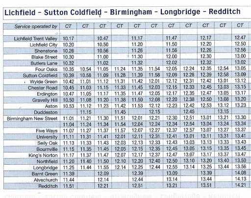
December 2024 to May 2025

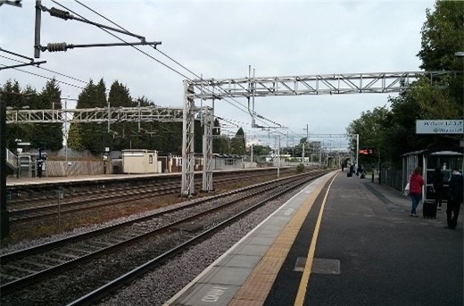
In the present 2024 winter timetable, this situation persists, for good or ill. The quality of the rolling stock has however increased with the use of Class 730 EMUs.

Class 730 EMU

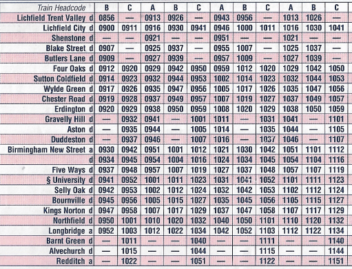
Journey times and leaf fall timetables

Finally, before I close, I will brielfy discuss journey times and leaf fall timetables, which are quite closely connected. I take the journey time between Lichfield City and Birmingham New Street as a comparative value through the years. In the 1960s, when the service was operated by Class 116 DMUs, the journey time was around 45 minutes, but by the close of the decade it had reduced somewhat to between 40 and 42 minutes. . After electrification with the introduction of Class 323 EMUs , this time fell to between 35 and 37 minutes. Current times with the Class 730 are still around 37 minutes.

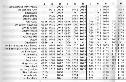
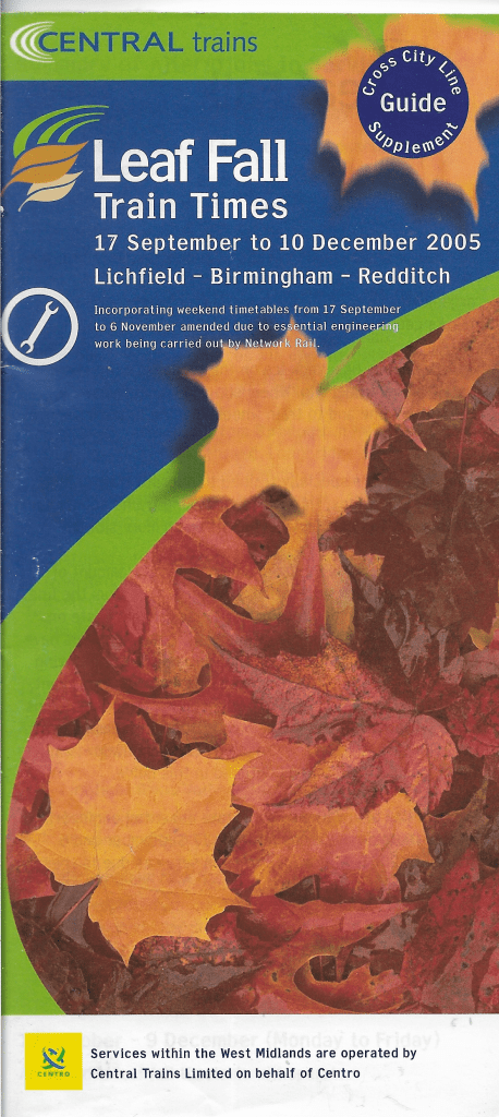
From the early 2000s a “leaf fall timetable” has operated on the Cross City line between October and December, when track conditions can become difficult. A typical example for 2005 is shown below. At the time the normal timetable consisted of six trains an hour, with two starting at Lichfield Trent Valley, two at Lichfield City and two at Four Oaks, with four terminating at Longbridge and two at Redditch. The revised timetable shows four trains an hour, with two starting at Lichfield Trent Valley and two at Four Oaks, with two terminating at Longbridge and two at Redditch. Journey times from Lichfield City to Birmingham New Street were 45 minutes. There was thus both a significant reduction in service frequency and a significant increase in journey time in the interests of maintaining reliability.

Closing remarks

As I said at the start of this blog, the history of services on the Cross City line show a commendable ambition on behalf of the operators, but with this ambition compromised by lack of operational reliability. The six train per hour service that operated from 2003 was notoriously unreliable, with this unreliability in the peak leading to significant overcrowding as two trains worth of passengers often tried to squeeze onto one, with most trains having only three coaches. Perhaps the current less frequent timetable, but with longer trains, is more satisfactory in that regard. The unbalanced timetable, with alternating ten and twenty minute gaps between trains is far from satisfactory however. If one is optimistic, one might say that this will allow six trains per hour to be reinstated in the future, but if this is not going to be the case, the timetable really does need recasting with a consistent fifteen minute interval.

Lichfield – a pre-conversion pagan cultic centre?

First published on this site as a web page in April 2020, but format changed to post in August 2024 for consistency with other material

Introduction

It has been noted by a number of authors in the past that in the vicinity of Lichfield, the ecclesiastical centre of the Mercian kingdom, there are a number of place names with pagan religious associations, and puzzlement has been expressed that such names were allowed to survive by the ecclesiastical authorities (Horowitz, 2005, p32). In this article, we consider these names further and identify a small number of other sites in the locality that may also have pagan religious connections. In so doing we are led to the tentative conclusion that Lichfield may have been a centre for pagan religious activity in the pre-Christian era, and the echoes of this activity, remain in place names and church dedications in the area. This suggestion goes some way to explain the rather odd comment recorded in an early life of St Wilfred, that he gave Lichfield to Chad for the site of his cathedral in 669, as it was suitable place for an episcopal see – in that it was already an ancient cultic site (Colrave, 1927). We begin in the next section by briefly considering the work of North (North, 1997), who investigated in particular the deity known as “Ing-Freyr”, for reasons that will become obvious in what follows. We then move on to a consideration of place names and church dedications in the Lichfield area. An attempt is then made to synthesise the findings, and to draw out their implications. Finally, further possible indications of cultic activity in the Lichfield area in the Roman / British era and before are briefly mentioned.

Ing-Freyr

Ing-Freyr by Hugo Hamilton

Through a detailed examination of the work of the Roman Historian Tacitus who described the worship of the Angles in southern Denmark in the first century AD; the much more recent Scandinavian myths recorded in Iceland around 12thand 13thcenturies; king lists from the early English kingdoms and a range of Old English literature from the Anglo-Saxon period, North arrives at the conclusion that the worship of the deity “Ing-Freyr” can be detected in England before the conversion. He argues that the cult of Ing-Freyr directly descends from that of Nerthus, who seems to have had the attributes of a sky god, in the early Roman era by the Angles in southern Denmark. Tacitus describes this  as centring on a oxen hauled wagon procession of the god, either represented by an idol of by a nominee, around the tribal region, with the celebration of a marriage to the earth goddess Terra Mater, symbolised by copulation with local women or with a nominated female. This rite had obvious fertility aspects, and also seems to have involved the “death” of the God (either through the symbolic interring of the idol, or perhaps through human sacrifice) after the wagon tour, and his resurrection in the following spring. The suffix “Ing” can be found in a number of early Anglian king lists, indicating the persistence of the cult into the Anglo-Saxon era and can be traced through various Old English texts. Freyr simply means “Lord” and in the Nordic myths was the son of Njoror (the equivalent of Nerthus) and the brother of Freyja, who were all members of the Vanir, the old gods who were the losers of a cult war with the Aesir headed by Odin. The name Freyja simply means “Lady” and is widely regarded as a fertility deity, and also as a “psychopomp” who attended to the souls of the dead. In some myths she is identified with Frigg, the wife of Odin The concept of a dying and rising God has of course resonances with Christianity, and North, somewhat mischievously, writes

…the Angles, in particular, offered no resistance to Christianity and indeed failed to perceive the difference between the new religion and their own…. (North, 1997, 305)

However, whilst the cult of Ing-Freyr could clearly have played a part in the conversion of the Angles, ultimately for the Church there was the possibility of much confusion with the orthodox faith that was potentially very damaging. There is some evidence that the Church thus came to equate Ing-Freyr with the devil (North, 1997, 56-57, 325), and the cult was firmly suppressed. This was partly achieved through his replacement in king lists and names by Odin, an ambiguous figure, both a deity and a real or semi-mythical Swedish ancestor, but who was clearly not regarded as a threat to the church in the same way as Ing-Freyr[vi].  One of the attributes of Odin himself was that of the psychopomp.

Whilst the arguments of North are based on widely diverse sources, both in terms of content and date of composition, they are nonetheless cogently argued and present a convincing case that, in the pre-conversion era, the cult of Ing-Freyr could be found amongst the Anglian peoples of Britain. The implications of this for the Lichfield area will become clear in the following sections.

Place names and Church Dedications

The name of Lichfield itself remains something of a mystery (Horowitz, 2005, p16). The early (medieval) understanding, based on the writings of Matthew Parris, a monk of St Albans, was that it carried the meaning “Field of the dead” and was the site of the martyrdom of Christians during the persecution of Diocletian from 284 to 305, with “Lich” being derived from the Old English word for body or corpse. Early spellings of the name however suggest that such an interpretation is at best debatable, and the accepted wisdom is that the name derives, through a complex system of intermediate forms, from the Celtic word that evolved into Letocetum (Wall) in the Roman era, and means the open place by the grey wood (Horowitz, 2005, p17). What the grey wood might be has however not been explained, although of itself it to some degree numinous, with perhaps some symbolic meaning and content relating to the dead or the supernatural.

If the name of Lichfield cannot be fully explained, other names in the vicinity are less ambiguous. There are two “Woden / Odin” names to the west – at Wednesfield (Horowitz, 2005, p566) and at Wednesbury (Horowitz, 2005, p565), with names that mean the open land dedicated to Woden, and Woden’s fortification respectively. A little way to the east, on Watling Street, we find Weeford – the ford of the idol or shrine (Horowitz, 2005, p29). Less certainly, in between Weeford and Lichfield, we find Freeford (Horowitz, 2005, p32) (Horowitz, 2005, 30), . Whilst this might simply mean free, or unrestricted, ford, a possible variant is Freyja’s ford, which, in view of the theories of North set out above, may well be of some significance. Weeford and Freeford were two of the five original (and quite possible pre-Domesday) prebends of Lichfield Cathedral, the others being Longdon and Handsacre to the west, and Stotfold or Statfold to the east. 

Freja (1905) by John Bauer 

However there are a small number of other sites that may have connections with pagan worship in the area. The first is the last of the five prebends just mentioned. Stotfold (Horowitz, 2005, p510) carried the meaning of (horse or oxen) stud fold. The horse itself had ritual significance in the Anglo-Saxon period, but it is the possible association with oxen that is clearly of significance to the current discussion.  Also, just to the south of Freeford we find Ingle Hill (Horowitz, 2005, p336). Horowicz is not certain on the derivation of this, offering a rather tenuous connection with the Inge family who were apparently in the Lichfield area in the 18thcentury. The root however is exactly the same as Ingham in Lincolnshire, Norfolk and Suffolk (all regions of Anglian migration), which does seem to be connected to the deity Ing (Mill, 1991). We thus have the names Weeford, Freeford, Stotfold, and Ingle Hill all in close proximity, and whilst the derivations of all but the first are arguable, their geographical coincidence strongly suggests a connection with pagan ritual. All these places are also part of a large land unit that was eventually to become the Domesday manor of Lichfield, and then the large parish of St Michael’s Church on Greenville (James, 1998). Basset (1992) argues that this was actually a pre-Augustinian British Diocese, and whilst this may be possible, it may be simply a land unit that arose for different reasons. Finally, there is the possibility that one of the members of the Domesday Lichfield land unit, Tymmore (whose meaning has not been addressed by place name scholars) could refer to the god Tyr, the moor in question perhaps being Whittington Heath to the east of Lichfield (Morris, 1976). Place names thus suggest an unusual level of pagan activity or memory in the Lichfield area in the period from which the settlement names derive

Memorial plaque to Michael Lowe of Tymore in St Michael’s church, Lichfield

Within Lichfield, there are three parish churches and the cathedral. Bede tells us that the latter was originally dedicated to St Peter and St Mary (Kettle andJohnson, 1970), but at least by Domesday, the dedication was to St Chad and St Mary. Thus the dedication was to the “Lady” of the Christians and to the chief apostle, and latterly to the major local holy man. The three churches are dedicated to St Mary, St Chad and St Michael. The first was a medieval creation for the planned town of Bishop Roger de Clinton in the 12thcentury. Of the latter two, the land unit evidence discussed by Basset suggests that St Michael’s is the older, and that St Chad’s parish was originally included within it (as were the parishes of St Mary’s and the Cathedral Close). In St Michael we have both the angel who threw the devil to earth from heaven, as well as the Christian psychopomp. The huge size of St Michael’s graveyard has frequently been pointed out, and whilst this size may be purely functional, it might nonetheless indicate early association of the area with the concerns of the dead (James, 1998). 

Of the three prebends of Lichfield discussed above, Freeford and Stotfold have no chapels of their own and seem to have always looked to St Michael’s as the mother church. The church at Weeford is again dedicated to Mary. Away from Lichfield, there does not seem to have been an ancient church at Wednesfield, but at Wednesbury the hilltop church is dedicated to St Batholomew. Interestingly there are two other Bartholomew dedications in the vicinity – at Hints on Watling Street near Weeford to the east of Lichfield, and at Farewell to the west. Bartholomew is one of the lesser known of the disciples in biblical terms, but one of his traditions relates that he was martyred by being skinned alive. He is regarded as the patron saint of tanners, which is perhaps a tenuous connections with the ox wagon procession that is identified herein. He is also identified with Heracles, perhaps through a similarity of iconography, with Heracles holding the skin of the Nemean lion in a similar manner to Bartholomew holding his flayed skin (Crane and Lazzarotti, 2014),  and through Heracles / Hercules to Balder, the dying / rising God of  Norse myth, which is shown by North to be identified with Ing (North, 1997, 143).

Finally the church at Shenstone to the south of Lichfield, is dedicated to St John the Baptist, whose feast day is on midsummer eve. There is a long and proven European tradition of midsummer bonfires on hilltop sites (possibly where bones were burnt) that goes back to Roman times (Hutton, 1996), and the dedication to St John suggests that these occurred at Shenstone, and might go some way towards explaining the rather curious name (Horowitz, 2005, 488), which means “Shining Stone”. There are no obvious stones to which this could apply in the vicinity, but the name could conceivably apply to an idol illuminated by a bonfire.

Synthesis

At this point it would be easy to fall into wild speculation concerning the implications of all the above, and perhaps particularly on the route that might have been taken by an ox drawn idol bearing wagon. We resist that here and simply emphasise two major points. The first is that place name evidence strongly suggest that the region around Lichfield was the centre of a cult of Ing-Freyr, and perhaps Freyja, with some indications that the ancient wagon procession cult was at least remembered if not wholly practiced – the names of Freeford (Freyja’s ford), Ingle Hill (Ing- Hill), Weeford (Idol ford), Stotfold (Oxen or horse fold) and perhaps Shenstone (Shining Stone).  This implies the early existence of both a fertility cult, with an annually dying and rising deity, and with a cult of the dead.  The second point is that this cult seems to have been supressed in exactly the way that Pope Gregory recommended to St Augustine – to use and hallow the pagan shrines for Christian worship. The three pagan sites of Weeford, Freeford (which includes Ingle Hill) and Stotfold were eventually to become prebends of Lichfield Cathedral; the worship of the Lord Ing-Freyr and the Lady Freyja was replaced by the worship of Christ as mediated through the chief apostle Peter and the local holy man Chad, and “Our Lady”, the Virgin Mary. The pagan psychopomp Freyja was replaced by the Christian version, the Archangel Michael, who from the summit of Greenhill would proclaim the Christian victory over the Lord and Lady of the Vanir. Away from Lichfield itself, the fires at Shenstone, that perhaps used to illumine the travelling idol, became dedicated to St John, and whatever occurred at Wednesfield, Wednesbury, Hints and Farewell was neutered using the ambiguous name of Woden / Odin, and the rather dramatically martyred St Bartholomew. But the suppression was not wholly complete. Some of the names in the vicinity were too deeply ingrained in the local consciousness to be eliminated completely, and the association of Lichfield with both the cult of the dead and with fertility was to endure, through the long history of the graveyard at St Michaels, and through the Greenhill Bower respectively.  Interestingly, and perhaps amusingly, as late as the 14thcentury the incumbents of the (once pagan) prebends of Freeford, Weeford and Stotfold still appointed chaplains to the three (Christian) city churches of St Mary, St Chad and St Michael (Greenslade, 1990).

In the above no attempt has been made to give chronological depth to the above suggestions and give suggested dates other than the firm one of 669 for the beginning of Chad’s episcopate. Place names and church dedications simply do not allow a precise chronology of the interaction between pagan and Christian worship to be developed. So we have simply set out the evidence that suggests that, in the pre-conversion period, there was a significant and identifiable pagan activity in the Lichfield area, that had both fertility and mortuary aspects, and was ultimately supressed, albeit far from effectively, by the Christian church.

Earlier possibilities

We have concentrated above on the interface between Anglian pagan worship and Christian worship, potentially in the sixth and seventh centuries. However there’re a number of indications that the Lichfield area might have cultic past that goes back further than that. James (1999), based on the work of Morris (1989), argues that the church dedication to St Michael on Greenhill could have displaced an earlier cult of Mercury, who has many of the same attributes, including that of psychopomp. In turn this could be related to the cult of the Celtic / British deity Lugos, who again had the same attributes. Also, as noted above, Bassett (1992) argued that St Michael’s could have been the centre of a late Roman ecclesiastical diocese. How the various competing cultic sites of the Roman / British and Anglo-Saxon periods might have related to each other is not at all clear.

Going back still further, it is quite possible that Lichfield itself is part of a major solar alignment, with the Cathedral, St Chad’s Well, and the Bronze age site at Catholme all being on a midwinter sunset / midsummer sunrise alignment. The cultic implications of this are the subject of speculation is a related blog post.

References

Basset S (1992) “Church and diocese in the West Midlands; the transition from British to Anglo-Saxon control”, in Pastoral Care before the Parish, ed. J. Blair and R. Sharpe (Leicester University Press), pp13–40.

Colrave B (ed) (1927) “The Life of Bishop Wilfred by Eddius Stephanus”

Greenslade M W (1990) “Lichfield: Churches”, in A History of the County of Stafford: Volume 14, Lichfield, pp. 134-155 http://www.british-history.ac.uk/vch/staffs/vol14/pp134-155

Crane T F, Lazzarotti M (2014), Ed. Tales From Italy: When Christianity Met Italy, M&J ISBN 9791195174942 p5

Horowitz D (2005) “The Place Names of Staffordshire”, published by D Horovitz, Berwood

Hutton R (1996) “The Stations of the Sun – a History of the Ritual Year in Britain”, Oxford University Press, 311-321

James T (1998) “The development of the parish of St Michael-on-Greenhll over 1500 years”, St Michael’s Papers; number 1, St. Michael’s PCC

James T (1999) “St Michael’s dedication, associations and imagery”, St Michael’s Papers; number 2, St. Michael’s PCC

Kettle A J, Johnson D A (1970) “A History of Lichfield Cathedral”, Victoria County History of Staffordshire, Volume III

Mill AD (1991) “Dictionary of English Place Names”, Oxford University Press, p187

Morris J (1976) Staffordshire Domesday, Phillimore, Chester

Morris R (1989) “Churches in the Landscape”, pp 54-55, Phoenix Giant

North R (1997) “Heathen Gods in Old English Literature”, Cambridge Studies in Anglo-Saxon England 22, Cambridge University Press

Lichfield’s first railway station?

In 2020 I published a blog post entitled “Lichfield Trent Valley 1847-1871” – a study of the “first” railway station in Lichfield that was built when the Trent Valley Line opened in September 1847, and shown in the engraving above. The figure below, reproduced from that post, shows the location of this station in relation to the station of the South Staffordshire Railway that crossed the Trent Valley line and the second (existing station). The underlying map is the 1848 Tithe map of the township of Streethay where the station is situated.

Extract from 1848 Tithe Map (red solid circle LNWR station location 1847-1871; red dotted circle – approximate SSR station location 1849-1871; green oval – location of current station

In 2021, I published a further post “Lichfield’s first station master” that looked at the life and times of William Durrad, the first to hold the position of Stationmaster. Both posts were gratifyingly quite widely read.

However a few days ago, I was browsing the 1851 census returns for Streethay (from which it might be concluded that I lead a rather sad existence). Sure enough, William Durrad and his family were there living at the railway station. But two pages earlier I came across the following entry.

Extract from the 1851 census for Streethay

It can be seen that it refers to Richard Mooney and his extensive family. Richard was a gatekeeper for the Trent Valley Railway and lived at the Old Station. Remember this was in 1851, when the railway had only been opened four years and, as far as anyone knows, the station that was built un 1847, the one shown above, was still in existence. What on earth was this “old station”? Looking at the order in which properties are listed on the census, the location of Richard Mooney’s dwelling can be quite precisely located, and is shown on the figure below, again on the 1848 tithe map. It can be seem to be where a road (the Old Burton Road) crosses the railway on a flat crossing – and thus the building shown is an ideal location for a Gatekeeper’s cottage. If this was a station, it was in use very briefly between the opening of the railway in September 1847 and the preparation of the tithe map sometime in 1848. Perhaps it was a temporary arrangement – simple platforms that were in use as the main station was being completed. It is also quite possible of course that the census entry is incorrect and based on erroneous information from Richard Mooney or the enumerator.

Extract from 1848 Tithe Map (red solid circle LNWR station location 1847-1871; red dotted circle – SSR station location 1849-1871; green oval – location of current station; purple circle – the location of the “old station”

So my initial post may not have been entirely accurate – it seems to me that there is a real possibility that there was, albeit for a very short time, an earlier station than the one I described in my earlier post. Sadly, there is nothing left of it on the ground. The crossing was replaced by a narrow bridge in the early 20th century, and this bridge was itself recently replaced by a much more substantial structure leading to the new cark park at the station. Any traces of the “old station” would have been destroyed when the foundations of the latter were being laid.

Lichfield’s first station master

In this post I will consider the life and career of Lichfield’s first Station Master, William John Durrad (1817-1889). All the information in this post is gleaned from public sources – registers of birth and death, census records, employment records and the local press. Whilst these can describe a life in broad terms, they cannot really give a proper picture of the person’s character and personality. But in the case of William Durrad, they do show a typical Victorian progression from humble origins to gentleman status, brought about through a mixture of patronage and effort, and cast some light on the life of Lichfield in the nineteenth century.

For the sake of readability, I have not given any sources of information in the text below – should readers be interested in where the detail comes from, please email me on bakercj54@gmail.com for further information.

Early years

William John Durrad was born in 1817, the second child John and Ann Durrad of the village of Welford in Northamptonshire and baptised in the parish church. To avoid confusion with others, I will generally refer to him as William John in what follows. The Durrad name has a long history in that area, with a John Durrad of the nearby village of Misterton (d1726), being part owner of the Lordship of the Manor and a considerable donor to local charities.  William John’s father, John (b1780), however seems to have been of humbler stock and is described at William John’s baptism as a weaver. William John had one elder sister and four younger brothers, at least two of whom died in childhood. Their relative lack of prosperity can be judged by the fact that in 1851 his elder sister Mary was a servant at a household in Lancashire and his younger brother Richard was a butler at a house in Surrey (where he was later to marry the cook). His father John died in 1826, and William John’s mother Ann married again in 1827 to William Sanders, an agricultural labourer, and had several other children. We will meet one of these, Stephen Sanders (b.1831), again in what follows.

William John next firmly appears in the historical record as an employee of the London North Western Railway in the mid-1840s. It is possible however, at least provisionally and with some conjecture, to piece together some aspects of his early life. The first clue comes from his obituary in the Lichfield Mercury in 1889 where we read

“Being brought into intimate relations with the late Archdeacon Moore, he was fortunate enough to secure the good wishes and kindly offices of that dignitary of the church, and by his influence obtained a situation under the London and North Western Railway Company in the early days of railway enterprise”.

The Venerable Henry Moore (1795 – 1876) was Archdeacon of Stafford from 1856 to his death in 1876. He was born at Sherborne, educated at Trinity College, Cambridge and ordained in 1819. In the 1840s he was vicar of Eccleshall near Stafford and Penn near Wolverhampton and was made Archdeacon of Stafford and Prebend of Handsacre in 1851. The pictures below show the sketch by the artists Henry Armistead for this effigy in the cathedral, and the finished monument.

The second clue comes from the rather unusual name of Durrad. From as early as 1839 to the end of the century and beyond, there was a store in Eccleshall trading under the name, firstly, of William Durrad, and later of Joseph Durrad. The early mentions of this firm in the press in 1839 were as an agent for the selling of “Woolriches Improved Diuretic Horse Balls”, “Simpson’s new antibillious pills” and “Wesley’s Family Pills”, but from 1841 it is referred to as “Stationers” and from 1844 onwards as “Booksellers”. The firm acted as a publisher of postcards and political pamphlets, and as the local agent for many weekly subscribing magazines. One of these pamphlet from 1847, “A Political Sketch of the Relative Position of England and France” by Herbert Rice Esq. can be read on Google books by anyone interested in that sort of thing.  A photograph of the shop from 1897 can be found here.

The 1861 census identifies the owner of the bookstore as William Durrad, born in Leicester in 1821, and described as “Painter and Bookseller, organist, distributor of stamps”. This younger William was the son of a James Durrad, born in Welford in 1798. It seems very likely, given that they were both born in Welford, that James Durrad was related in some way or other to the William John’s father John, possible a younger brother or nephew. Note William’s age however – in 1839, when we first hear of the firm, he would only have been 18 years old.  Unfortunately, none of the sources give a middle name that can be used to identify him more precisely, and we will refer to him as the younger William in what follows. There is however a tantalising reference to W. J. Durrad from 1843 in a press advert for  Wesley’s famous product.

The third and final clue is that in the London North Western Railway records, William John’s profession before entering the service of the company is given as “bookseller”.

Thus, we can conclude that in the early 1840s William John and the younger William, who were probably cousins, were owners of a bookshop in Eccleshall, with William John, at least at first, being the senior partner. It is likely that the W. J. Durrad mentioned above from 1843 refers to him. It was there that they met Henry Moore, then the vicar of the parish, who could be expected, given his background, to be something of a bibliophile. From that meeting, the influence of the clergyman was enough to find William John a position in the London and North Western Railway. The bookshop was presumably left in the hands of the younger William and was eventually taken over by his younger brother Joseph (b1838) in the 1860s, after Joseph had worked as an assistant in a bookshop in Leicester, when the younger William retired.

Of course this leaves the question unanswered as to how William John came to be in Eccleshall in the first place, where he obtained the education that was presumably required to operate as a bookseller, and how he obtained the necessary resources to open a shop at all. It is unlikely that these questions will ever be answered.

Station Master and family man

We first read of William John in the London North Western Railway records as being, in 1845, the Lichfield agent for the company. As the company wasn’t in existence until July 1846, he was presumably an agent for one of the companies that ultimately came together to make up the LNWR – probably the Trent Valley Railway. His duties were thus to represent the interests of the railway during its inception phase. He was paid either £100pa or £130pa – the sources are contradictory. By the time the station opened in 1847, he was the designated Station Master, on a salary of £120pa. He was also at that stage a married man, having married Elizabeth Lowe, at Tettenhall in April 1846. There is no indication of how or where they met.

The employment records note that William John joined the railway when he was 21, which seems like an error, as that would be in 1838, 5 years before parliamentary approval was given for its construction, and too early for the bookshop to be left in the hands of the younger William. However, his obituary of 1889 says that, before coming to Lichfield, thanks to the good offices of the Archdeacon, he worked for some time at Edge Hill station in Liverpool. This had been in existence since 1831 as part of the Liverpool and Manchester Railway. It is just about possible, given the constraints on his timeline, that he worked there in 1844 or 1845 before moving to Lichfield. However, there is another possibility. In the LNWR records we find reference in the mid-1840s to Stephen Sanders, William John’s half-brother, calling himself Stephen Sanders Durrad, as being employed at Lichfield under William John’s supervision and later at Edge Hill as a clerk. This might possibly be the cause of the confusion.

I have described the original Lichfield station in another post. Basically, it was situated on the west side of the Lichfield / Burton road which the railway crossed on the level, i.e. on the opposite side to the current station. The picture below shows the rather grand style that was adopted by the architect John William Livock. The station building contained not only the passenger facilities and offices, but was also the Station Manager’s House, for which William John paid £15 a year in rent. To the east of the station and the Burton road, from 1849 the railway was crossed by the South Staffordshire Railway (now the Cross City line). This had a station to the north of the crossover entitled Lichfield Trent Valley junction. The South Staffs Railway was leased to the LNWR in 1861 and absorbed into the company in 1867. Clearly having two stations was inconvenient for passengers and both stations were closed in 1871 and a new station, with low level and high-level platforms, opened at its present site.

William John was the Station Master for the entire life of the original Lichfield station, with a wide range of responsibilities for the passenger and freight traffic, and for a significant number of staff. It is difficult to be precise about staff numbers as only the clerks and the porters tend to be mentioned in the records, when in reality there would have been a range of others associated with the adjacent freight yard that William probably had some responsibility for.  That being said, in 1847 there were seven named staff – Stephen Sanders Durrad mentioned above in a temporary post, plus six porters.

William John’s and Elizabeth’s children were born at regular intervals over the first decade and a half of his tenure as Station Master, and all were baptised at St Michael’s church, the station being situated in Streethay, a township at the northern end of the parish. William Henry was born in 1848, Arthur James in 1850 (confusingly named as Alfred on the census return of 1851), Walter Richard in 1852, Emma Helen in 1853 and Bertram George in 1860. With them in the house there were a succession of young servant girls which indicates that the family were comfortably off. William John’s salary steadily increased – to £130pa in 1853 and £135pa in 1859.

From time to time we see mentions of him in the press. In 1855 he was a witness in the trial of William Marson, who was charged with stealing two trusses and a large quantity of cloth from a wagon that had arrived from Stafford last in the evening and not unloaded till the day after. This is interesting in indicating his responsibility for the goods traffic as well as the passenger traffic. In 1869 he was a witness at an inquest into the death of Charles Lees from Barton-under-Needwood, a goods brakeman for the LNWR, who was working on a train from Wychnor to Shrewbury. At Lichfield it was engaged in shunting activities to leave some wagons behind and pick up some others. This involved moving trucks down the rather steep incline from the old South Staffs station to the Rugeley sidings at low level. Acting very much against the company rule Lees uncoupled the wagons as they rolled down the incline, fell and his leg was crushed by the following wagons. His wounds were bound up as far as possible, and then William John decided to have him taken by train to Stafford, as this was the quickest way to get medical attention. However, he died of his injuries, although the inquest jury agreed that Durrad’s actions had been appropriate.

It has been mentioned that all William John’s children were baptised at St Michael’s parish church, and his obituary specifically mentions his ongoing involvement with the activities there.  A picture of the church after the ill-fated restoration of the 1840s is shown below. He was a Churchwarden there in the 1850s. The registers of the parish reveal a rather curious incident in 1869. Emma Helen Durrad, then aged 16, was recorded as having been baptised as an adult at a private ceremony, and this was entered in the registers. The incumbent at the time, James Sergeantson, must have been aware from a register entry of 16 years before by his predecessor Thomas Gnossall Parr that she had already been baptised as an infant, and thus this was certainly in breach of canon law. Why and where the baptism took place, and why Sergeantson agreed to enter it into the register is not clear. Perhaps she had become involved with a non-conformist body that insisted on adult baptism, and the parents were trying to regularise this and perhaps put the Rector under some pressure to make an entry in the register?

William John Durrad resigned from his post as Station Master in June 1871, by which time his salary was £150pa. Why is not at all clear – but perhaps the fact that he would be required to move into less palatial accommodation when the new station was built may have been a factor.  There was a collection for a testimonial in the town, announced in the press, that raised a considerable (but not specified) sum. In the census of April 1871 all his children were still living at home. William Henry (22) was cashier at Lloyds Bank in Rugeley ; Athur James (20) was an undergraduate at Jesus College, Cambridge (and presumably on vacation), Walter Richard (19) was also a bank clerk; whilst Emma Helen (17) and Bertram George (11) were identified as scholars. Both Arthur and Bertram attended Lichfield Grammar School and Loughborough School – and this may well have been the case for William and Walter too. William John’s brother Richard also lived close by – he and the cook he married when he was a butler in Surrey were now running an Inn in Rugeley – and when he died in 1874, William Henry was to act as one of Richard’s executors.

A Civic Official

After his retirement William John and his family moved to Misterton Cottage. This is on the corner of Trent Valley Road and Wissage Road and still exists – as Holly Lodge – in the grounds of the Samuel Johnson Hospital – see the map and photograph below. It may indeed have been newly built at the time, perhaps under the direction of William John, as it does not appear on the 1848 tithe map but is present in the 1880 Ordnance Survey map. Its name is of course an echo of the Durrad’s roots in Northamptonshire. It was a substantial property. When it was eventually sold in 1890 it is described as being comprised of

Entrance Hall, Two reception rooms, Kitchen, Scullery, Pantry, Cellar, Four bedrooms, dressing room and WC. Well laid out gardens and a quarter of an acre of land.

Shortly after his resignation from the railway, William John took up the post as High Bailiff at Lichfield County Court, based in St. John’s Street, which he was to retain for the rest of his life. In this role he was responsible for executing warrants and court orders. He also had ecclesiastical responsibilities that may have dated back to his time as Station Master. Firstly, he was Apparitor to Archdeacon of Stafford, with the responsibility to summon witnesses and execute the orders of the ecclesiastical court. The Archdeacon, up to 1876, the Venerable Henry Moore. Secondly, he was sub-librarian in the Cathedral library, so he obviously retained his bibliographic interests. Both of these positions would have supplemented the pension from the LNWR.

In his civic roles he appeared regularly, if briefly each time, in the local press in the 1870s and 1880 – at the Mayor’s luncheon, the Sheriff’s breakfast and the perambulation of the city. He was also active in the St John’s Freemasons Lodge end held office there – as Junior Deacon in 1870 and as Junior Warden in 1876.  He also featured on an annual basis in the published list of partners in the Lloyds Banking Company Ltd., together with his son William Henry, who rose to become a Bank Manager in Rugeley in this period.  Presumably again, this was an additional source of income.

Walter Richard was married in 1874 to Sarah Stevens from Hertfordshire, and in the same year Arthur James, having graduated from Jesus College, was ordained Deacon in York. January 1882 saw the death of William Henry in Rugeley, from “congestion of the lungs”. A muffled peal of bells was rung at St Michael’s after evensong on a following Sunday, where both William Henry and his father had been regular ringers. Just two weeks after William Henry’s death, Bertram George, the youngest child, having also graduated from Jesus College, Cambridge, was ordained Deacon in Lichfield Cathedral. The following year William’s wife Elizabeth died from heart disease. Bertram married Margaret Wright from Marston Montgomery in Derbyshire in 1888. In 1881 Emma was a teacher and companion to the daughter of Frances Carver, a widowed farmer in Whaddon in Cambridgeshire.

Last days

William John died in January 1889. His obituary records that he had been ill for several weeks beforehand following an operation from which he was never to recover. The lead mourners were of course his family – Arthur James, by then Vicar of Ellerburne near Pickering; Walter Richard, Foreign Correspondent’s Clerk at Coutts in London; Bertram George, the English Anglican Chaplain in Berlin; Emma Helen; and Mrs W. Durrad and Lizzie Durrad. The latter were the second wife and daughter of his cousin, the younger William from Eccleshall. His first wife Louisa had died in 1879, without having had children, and having moved to London, he married Elizabeth Whittle, 24 years his junior in 1881. Clearly William John had maintained contact with that branch of his family over the years. The funeral was a full choral service and at the burial the choir gathered around the grave and sang the hymn “Now the Labourer’s task is o’er”.

An obituary notice appeared in the February 1889 edition of the St Michael’s church Magazine, which sheds some further light on his work for the church.

William John, his wife Elizabeth and his son William Henry are buried together in one grave in the graveyard of St Michael’s church. It is currently (May 2021) somewhat overgrown and difficult to access. Nonetheless its design is rather unusual as can be seen below.

They are also commemorated in floor plaques in the church at the front of the chancel beneath the pulpit, These are positioned (deliberately?) on the opposite side of the chancel to two similar plaques commemorating the lives of two of the 19th century Bishops of Lichfield (Selwyn and Lonsdale) – see below. I strongly suspect this placement was deliberate on the part of the family and church leaders. This is perhaps a final indication of the perceived importance of the Station Master in Lichfield society at the time. 

The Durrad Memorial tablets in St. Michael’s Lichfield
The memorials to Bishop Londsdale and Bishop Selwyn
The placing of the Durrad memorials in St Michael’s. When the memorials were installed, the main font would have been just to left of the Bishop’s plaques. (For those who can spot such things, the combination of the Advent Candle ring on the left and a container of sanitizer on the pulpit steps on the right marks this photo as having been taken in December 2020.)

The Durrad memorials contain a further point of interest, in the symbols at the bottom of each plaque beneath the names. On that of William Henry, it is a fairly conventional and formal fleur -de-lis. On Elizabeth’s, we have the snowdrop – seen as a symbol of both death and rebirth. On William John’s plaque we have the Speedwell, or Veronica, a symbol of sympathy and mourning . Perhaps these decorations were deliberate and say something of the families feelings and the characters of those commemorated. Alternatively they may just have been what was available from the manufacturer’s catalogue!

In his will, with Arthur James and Bertram George named as executors, William John’s effects are said to be worth £3138, a very considerable sum. What this refers to is not clear, but probably includes Misterton Cottage and its contents, some land off the Walsall Road as well as his personal effects and any other savings . The year after the funeral Emma Helen married Frances Carver of Meldrith in Cambridgeshire (for whom she had worked as his daughter’s teacher and companion), Misterton Cottage was sold, and the Durrad family finally severed its connections with Lichfield.

A historical curiosity – Fog Cottages

The original Lichfield Trent Valley station

Next to the original Lichfield Trent Valley station (north if the current one – see my blog post at https://profchrisbaker.com/…/lichfield-trent-valley…/ ) the OS map of 1900 shows a row of cottages that the census return names as Fog Cottages as shown in figure 1 below.

Figure 1. Lichfield Trent Valley 1900 OS map

I noticed recently whilst out walking that there is another similarly named row of cottages just beyond Rugeley Trent Valley station. This is not shown on the 1900 map, but is there on the 1920 map, again shown on Figure 2.

Figure 2. Rugeley Trent Valley 1920 OS Map

The Staffordshire Past Track website has a picture of these cottages at https://www.search.staffspasttrack.org.uk/Details.aspx… with the following explanation for the name.

“A postcard view of Fog Cottages, on the Colton Road near Trent Valley Station, Rugeley. They acquired the name Fog Cottages because the end cottage had an alarm bell installed and this was used in foggy conditions to call out the railway men who lived in the cottages to go and place fog detonator alarms on the nearby rails to assist the train drivers.”.

A modern view of the Rugeley Cottages (from Google Street View) is shown in Figure 3 below.

Figure 3. Fog Cottages, Rugeley

The question then arises as to whether the name of Fog Cottages has more widespread use. And the answer is that it does. Mathams and Keshall (2014) present an old photograph of a now demolished set of Fog cottages at Amington, next to the LNWR line north of Tamworth (Figure 4).

Figure 4. Fog Cottages Amington (Mathams and Keshall, 2014)

Rightmove (perhaps one of the more unusual historical sources!)  reveals that there are Fog Cottages at Watford, Collingtree and Althorp Parkin Northamptonshire and at Tring in Hertfordshire (see the Google Street View shots of these in figure 5). There are almost certainly more that I have not identified. All are next to the LNWR line, but only some are near stations or the sites of former stations. On the Amington Cottages Mathams and Keshall write

The LNWR standard cottages were built after 1883 when the design was introduced by Francis Webb, Chief Engineer of the LNWR and later examples – built after 1883/4 – are recognisable by the courses of stepped-out brickwork on the gable ends and under the eaves, and the four red-brick bands which run round the building in line with window sills and lintels, all of which can be seen in the picture below.  Nearly everything (except the slates) came from the LNWR works at Crewe;  bricks, woodwork and metal fittings.  

I can find no mentions of Fog Cottages other than in LNWR territory so it looks as if we have here a specifically LNWR naming policy. But if there are any occurrences away from the LNWR I would be pleased to be told.

Lichfield Trent Valley 1847-1871

Figure 1 The original LNWR station looking north (down platform on left; up platform on right)

As it stands today, Lichfield Trent Valley railway station is situated at the point where the West Coast Main Line (WCML) is crossed by the extension of the Cross City Line towards Burton-upon-Trent. It has three platforms – two low level platforms on the WCML and one high level platform on the Cross City Line. It lies to the east of Trent Valley Road, the old turnpike road from Lichfield to Burton. In this post, I will describe the earliest stations in this area that existed between the late 1840s and the early 1870s and will also describe the career of the first station master. It will be seen that the grandeur of the early station building and the status of the Station Master in Lichfield society indicates the importance and significance of the early railway system.

The original Lichfield Trent Valley station

The positions of the first stations in the area are shown on the Lichfield St. Michael parish (Streethay township) Tithe Map of 1848, an extract from which is given in figure 2. The current station location is indicated by a green oval. The original 1847 Lichfield station of the London and North Western Railway (red circle) is on the west of the Turnpike Road, with platforms on either side of the track, and the main station building on the down line. The station is illustrated in the drawing of figure 1 and can be seen to be quite a substantial affair, designed by the architect John William Livock in the gothic style. It was clearly designed to make a statement as to the importance and grandeur of the company. As was normally the case at the time, the platforms were much lower than is the case today. The Turnpike Road crossed the railway on a flat crossing rather than the current bridge, and it is likely that passengers also used this crossing.  The map also shows the line of the South Staffordshire Railway that crosses the London North Western line, although that was not completed when the map was produced and not opened until 1849. Its station (Lichfield Trent Valley Junction – indicated by the dotted red circle) was just to the south of the point where the  line crosses the Old Burton Road and was connected to the LNWR station by a chord as shown in the 1882 Ordnance Survey Map of figure 3. It is not known if there was also a pedestrian connection between the stations, but one can surmise that there was as otherwise the walk between the two would have required a considerable trek along local roads and tracks. (For those who know this area, this would have entailed a walk down Burton Old road in Streethay, to the current junction with Cappers Lane, which did not exist at the time, then along Burton Old Road east to the path across the Cross City line by the tip, then up Trent Valley Road to the other station.)

Figure 2 Extract from 1848 Tithe Map (red solid circle LNWR station location 1847-1871; red dotted circle – SSR station location 1849-1871; green oval – location of  current station)

Figure 3 1882 Ordnance Survey map showing the station sites (key as in figure 2)

Building survival after closure

To make connections easier, a new station (Lichfield Trent Valley) was built by the London North Western Railway in 1871 at its current location. This is shown on the 1882 Ordnance Survey Map in figure 3 and there can be seen to be station buildings on both the low level LNWR line and the upper level South Staffordshire line. Interestingly the old LNWR station building can still be seen on the down side of the line next to a set of sidings, although that on the up line has been obliterated by other sidings. This building survived into modern times, as can be seen on the 1970 Ordnance Survey map of figure 4. The realization that this building was around till then made me take a more careful look at some 1960s train photographs, and I was gratified to find a number of shots of the building, which are shown in figure 5. Those of figures 5a and 5b are taken from the Trent Valley Road bridge over the railway line, and those of figures 5c and 5d from track level on the west of the bridge. Clearly here the focus of the photographers was on the locomotives rather than the building, but they do show that the original station building survived in its more or less original form until modern times.  Perhaps one can even see a surviving gas light column – see the enlargements of figure 6 – although here I may be confusing a signalling column with a lamp stand.

Figure 4 1970 Ordnance Survey map showing the station sites (key as in figure 2)

Figure 5 1960s photographs showing the original LNWR station in the background

Figure 6 Gas lamp survival?

The later stations

The station buildings of 1871 survived until the 1970s when they, like so many elsewhere, were replaced by much less substantial structures – effectively portakabins and bus shelters. In 2014 a rather more substantial main building was constructed on the WCML down platform, and more recently lifts have been built to improve access to the high level platform and the up WCML platform. The various incarnations of the station are shown in figure 7. Figure 8 shows the site of the original South Staffordshire station – nothing now survives. The same is true of the LNWR station, although the site is no longer accessible and cannot be easily photographed (I have tried!). Nonetheless, the fact that the original LNWR  building survived for over a century was perhaps a historical accident,  but enables the grandeur and the ambition of the builders to be appreciated.

Figure 7 Later station buildings

Figure 8 The site of the original South Staffordshire Railway station

The first station master

The first Station Master of the 1847 station was William Durrad, born in Northamptonshire in 1819, the son of a weaver. He was married to Elizabeth, two years his junior. Their first son, another William, was born in 1849, and he was followed by Arthur in 1850, Walter in 1852, Emma in 1854 and Bertram in 1867. They continued to live in the old railway station building until the 1871, with a succession of live-in servants. All the children survived to adulthood, and two of them (Arthur and Bertram) were educated at Loughborough Grammar School and studied at Jesus College, Cambridge, both becoming clergymen. William junior and Walter worked in banks and the former became a bank manager in Rugeley. William senior retired from his role of Station Master in 1871 at the closure of the first station. and we next read of him in the local press as a Bailiff (law officer) in the County Court. He was clearly an important man in the locality and the press of the time frequently mention his name as an attendee at various civic functions.  William junior died in 1882 and Elizabeth in 1883. William senior himself died in 1889, living £3138 in his will, a very substantial sum. He is recorded as living at Misterton cottage on Trent Valley Road. These three are buried together in one grave in the graveyard of St Michael’s church. They are also commemorated in floor plaques in the church at the front of the chancel beneath the pulpit – see figure 9.  These are positioned (deliberately?) on the opposite side of the chancel to two similar plaques commemorating the lives of two of the 19th century Bishops of Lichfield (Selwyn and Lonsdale). This is perhaps a final indication of the perceived importance of the Station Master in Lichfield society at the time.  Now, as well as spending too much time writing blog posts, I am also a minister at St Michael’s church and it came as a surprise to me that I should have been walking over these memorials in the course of celebrating the eucharist for the last twenty years, yet having  not the faintest idea who they related to.

After the Durrads left the old station, the building seems to have been divided into separate residences, but in 1881 only one was occupied by a railway porter and his wife. There was however a considerable community of railway staff (labourers and platelayers) in the nearby railway cottages that can be seen in figures 3 and 4. Unfortunately the 1891 census records for the area seem to be missing (or at any rate I can’t find them), but by 1901 the old railway station was occupied by 16 people from four families of railway workers (porters, platelayers, clerks), including the station master David Brown, his wife Sarah and their five children. There were a further 28 people from five (mainly railway families) living in the associate cottages, by this time referred to as the Fog Cottages.

Figure 9. The Durrad memorials in St Michael’s Church

A study of the ancient prebends of Lichfield Cathedral

The Cathedral Prebends

In this post we will use the information provided on the Lichfield Tithe maps to investigate the nature of the Cathedral prebends. Until quite recently (in historical terms) members of cathedral staff (prebendaries)were supported by the income from various estates (prebends). In the case of Lichfield, there were basically two types of prebend – the first consisting of estates of various sizes that were leased for farming, industrial or residential purposes; and the second consisting of the income from specific ecclesiastical foundations. The system is well described in the Lichfield Cathedral section of the Victoria County History. At the peak of the prebendal system, Lichfield had 32 prebends, most of which were held by clergy who were only required to be in Lichfield for a few months a year. Twenty four  these were of the second type, based on the income from various churches in the diocese and eight of the first type based around specific land allocations. It is thought that five of these – the prebends of Freeford, Handsacre, Longdon, Statfold and Weeford were actually the estates that supported the five canons of Lichfield mentioned in the Domedasy book. Since the prebends are named after areas around Lichfield, it seems reasonable to assume that they consisted of specific areas around the city. Now for many of the properties that are listed, the tithe maps give an indication of which prebend they were in in the middle of the nineteenth century, and thus offer the possibility of mapping these prebends in more detail than has been previously possible. In what follows, we will thus attempt to do this, and it will be seen that it offers a description of the Anglo-Saxon geography of the area that is quite distinct from the later geography. It must however be stressed that what the Tithe maps show is the outcome of many hundred years of land sales, exchanges and re-organisations and thus absolute clarity on the original extent of the prebends is not to be expected.

Lichfield from Domesday to the Reformation

Figure 1. Lichfield and the surrounding area

(blue indicates rivers; solid brown lines indicate early, possibly Iron Age roads and trackways that survived to the present time, and dotted brown lines indicate Roman roads)

Figure 1 above shows the area around Lichfield, with the Rivers Tame and Trent and the early road system identified in the topographical studies of Stephen Bassett, that I have briefly described in an earlier post.  The names shown in regular type are the members of the Manor of Lichfield given in Domesday that lie in the vicinity of the city itself, and those in italic type are places that occur in other Domesday entries. It can be seen that the extent of the Manor was large stretching west to Hammerwich and east to the Tame at Tamhorn. There are some obvious gaps on the map – for example around Longdon to the west and Whittington to the east. There are also names not included on the map as their location cannot be identified – Horton, Burweston and Littlebeech. The important thing to observe from the perspective of the current investigation is that the three ancient prebends that are named on the map – Freeford, Hansacre and Weeford have no special importance over the rest. This suggest that if they are basic building blocks of a geography of the area, then this geography significantly predates Domesday and is very old indeed.

The town of Lichfield was set out by Bishop Roger de Clinton around 1140 and became styled as the Manor of Lichfield in its own right, with the rest of the area taking the title of the Manor of Longdon. Over the following centuries many of the members of the Manor became parishes in their own right (as we shall see below) and Lichfield itself shrank to the region of the what were to become the parishes of St Michael’s, St Mary’s and St Chad’s. Within this area there was no parochial system as such, with pastoral care being on the basis of the prebend. The three churches were staffed by the vicars of the five ancient prebends of Freeford, Handsacre, Longdon, Statfold and Weeford. A vicarage was created for St Mary’s with jurisdiction over the city centre in 1491 with the stipend paid from a number of prebends, with the five ancient prebends contributing the majority of the resource. The parishes of St Michael’s and St Chads came into existence in the seventeenth century, although they remained as perpetual curacies until the nineteenth.

Lichfield Parishes

The parishes in the wider area around Lichfield around 1840 are shown in figure 2, drawn with information from The Parish Atlas of England, by Tim Cockin.   The three Lichfield parishes can be seen to be of very different sizes, with St Michael’s parish extending a long way to the west at Burntwood, with a detached portion to the east at Fisherwick. St Chads, occupies the northern area of Lichfield, whilst the parish of St Mary and the extra-parochial areas of the Close and the Friary, are very small in comparison. Whilst much of the rest of the area shown in figure 2 is divided into parishes in the normal way, there are a number of extra-parochial areas, often representing areas of former or existing common land such as the Hays at Ogley, Alrewas and Kings Bromley.

Figure 2. Parishes in the Lichfield area around 1840

(1 – Kings Bromly Hay EP; 2- Croxall; 3- Ingale; 4- Thorpe Constantine; 5 – Statfold, 6- Hopwas Hay EP; 7- Freeford EP; 8 – St Mary’s, Lichfield; The Close EP; The Friary EP; 9 – Detached parts of Farewell)

The immediate area around Lichfield is shown at a somewhat larger scale in figure 3. The individual townships in St Michael’s and St Chad’s parishes are shown. It can be seen that the parish of Farewell and Chorley, to the west of St Chad’s parish has detached portions to the east.

Figure 3. Lichfield parishes and townships

The prebends mapped

Figure 4. Prebends in the Lichfield parishes

(Letters referred to in text; diagonal stripes indicate prebend to which tithe allocated; vertical stripes indicate region with name of prebend; red – Freeford; green – Weeford; blue – Statfold; yellow – Gaia Major)

The tithe maps give details of the tithes payable for each individual property that they list. Where appropriate they also give an indication of which prebend the tithe is allocated to. The information given varies somewhat in form from parish to parish, and thus we will consider each parish in the area around Lichfield below. We begin by considering the Lichfield parishes themselves in figure 4.

  • St Michael’s parish, St Michael’s township (A on figure). Here the prebendial split was at its most complex. Figure 4 shows only the regions that can be identified as part of Freeford prebend, which occur across the township, and probably indicates the major underlying land unit. The rest of the area was in the main occupied by land that was allocated to Freeford, Handsacre, Statfold and Weeford jointly, either as part of what is referred to as the Part Pound Tithing, or simply a two or more prebends being allocated tithes jointly. In addition each of these prebends were allocated the tithes from cluster of residential properties close to the city in the Greenhill and St John’s area. There was also a small area where tithes were allocated to the prebends of Bishopshull, Bishops Itchington, Prees and Pipa Minor, but in general the underlying prebend, seems to have been Freeford.
  • St Michael’s parish, Burntwood, Edial and Woodhouses, Wall and Pipe Hill townships (B, C, D). Almost uniformly the tithes in this area were allocated to Weeford prebend, again with allocations for small residential areas to the other prebends near the city. The large tract of land to the west is indicated on the tithe map as Burntwood Common and no prebend is indicated.
  • St Michael’s parish, Hammerwich township (E) Tithes in this are allocated to the “Appropriator” – the one to whom the rights to the tithes were sold at some point in the past. No prebends are given.
  • St Michael’s parish, Streethay township (F). Here the major allocation of tithes is to Statfold prebend (shown on the map), with some small allocations to Bishops Itchington, Curborough and Gaia Minor prebends.
  • St Michael’s parish, Fulfen township (G). As with Hammerwich, tithes are allocated to an Appropriator in this region.
  • St Chad’s parish, St Chad’s township (H). Here the situation is again complex. There are large allocations to Freeford and Weeford, together with a large allocation to the prebend of Gaia Major in the central area. There are also smaller allocations to the major prebends in the residential areas, and also small allocations to Bishopshull, Curborough,  Gaia Minor and Pipa Minor.
  • St Chad’s parish, Elmhurst township (I). The tithes of most of the land in this township are allocated to the Mark Part Tithing – jointly between Freeford, Weeford, Handacre, Statfold and Gaia Minor. There are some allocations to Bishopshull, Curborough, Gaia Minor, Handsacre and Pipa Minor prebends in the north.
  • Freeford extra parochial area (J). There is no tithe map available for this area, but it has been assumed on figure 4 that the entire area here was allocated to Freeford prebend, which does not seem unreasonable.

Figure 5. Prebends in the wider area around Lichfield

(Letters referred to in text; diagonal stripes indicate prebend to which tithe allocated; vertical stripes indicate region with name of prebend; red – Freeford; green – Weeford; blue – Statfold; yellow – Gaia Major; purple – Longdon; brown – Handsacre and Armitage)

Figure 5 shows a rather wider area around Lichfield indicating the situation in the surrounding parishes. The parishes of Longdon (A), Weeford (B) and Statfold (C) have tithes allocated to the vicar of the parish, or to an Appropriator, but are here marked as belonging to Longdon, Weeford or Statfold prebend. The outlying pat of St Michael’s parish at Fisherwick (D) has tithes with discrete areas allocated to Statfold and Freeford prebends. The parish of Aldridge and Hansacre (E) has tithes allocated exclusively to the prebend of Handsacre and Armitage, the successor of the ancient prebend of Handsacre. The tithes of the parish of Whittington (F) are allocated to the prebend of Whittington and Berkswell (the latter being in Stafford), which is a relatively modern prebend.  All the other parishes shown have tithes that are allocated to the vicar of the parish, or to an Appropriator. At this point it should be noted that there is a minor discrepancy between the tithe maps and material in the Parish Atlas for Farewell parish. On the tithe maps, the lower arm to the east of the parish is shown to be a detached part of Elmhurst township in St Chad’s parish, with its tithes allocated to Pipa Minor prebend, whilst in the latter it is shown as integrated into Farewell, as shown here.

Discussion

So what of the original premise of this post – can the ancient prebends be said to have well defined territories. I would suggest, on the basis of the maps of figures 4 and 5, the answer is a tentative yes. Let us consider each of the ancient prebends in turn.

  • The area where the tithes are allocated to Freeford, together with the eponymous hamlet, suggest that the original Freeford estate included most of St Michael’s township and part of St Chad’s and probably the city centre parish of St Mary as well. To the east it included Freeford, part of Whittington, the southern part of Fisherwick and perhaps extended to the river Tame through Tamhorn.
  • The territorial extent of Weeford prebend was very large, assuming that the later parish of Weeford was included within it. As well as the parish, it included the eastern part of Brownhills, Edial and Woodhouses township, Pipe Hill township and Wall township, as well as a small part of St Chad’s parish. It also possibly contained the Hammerwich area and the parish of Hints. Figures 4 and 5 suggest that part of Shenstone parish would probably have been included as well in order to make the eastern and western portions more of a coherent whole. If that were the case it would have been centred on Wall, the oldest settlement in the area at the junction of the Roman roads. In total it formed a wide arc around the southern and western edges of the city.
  • Statfold prebend extended from Streethay township in the west, through Whittington and the northern part of Fisherwick, and presumably to the parish of Statfold itself in the east. If it formed a coherent connected estate, it would have to have included parts of Elford and Clifton Campville parishes, for which there is no evidence.
  • The situation with respect to the two western prebends of Longdon and Handsacre is complex, probably because of the early formation of Longdon parish, and its role as the centre of the manor after the setting out of the town by Bishop Clinton. From figures 4 and 5 it can tentatively be suggested that it included Longdon parish itself, Farewell and Chorley parish, Elmhurst township and perhaps the area in St Chad’s parish allocated to Gaia Major. The latter could as easily be part of Weeford or Freeford prebends.
  • Handsacre prebend obviously included the later parish of Armitage and Handsacre in its entirety. If it ever extended closer to the city, it would have needed to include at least part of Kings Bromley parish and perhaps Elmhurst township too. There is no indication that this was ever the case. Geographically the parish boundaries suggest it may once have been associated with Longdon and perhaps represents and early division of the prebends in the Anglo Saxon era.

So what then might be the implications of this study? It points to an early Anglo-Saxon subdivision of the area around Lichfield into a small number of large divisions.  One of these, that later bore the name Weeford, was probably centred on Wall and was thus a territory associated with the Roman settlement of Letocetum.  Another, Freeford, seems to have embraced the location of the current city centre and extended eastwards a considerable direction. The -ford in Freeford has been taken to refer to the rather inconsequential ford over a brook close to the current Freeford House. If one accepts that Freeford originally encompassed the city centre, then the ford referred to might be the more substantial one that would have crossed the Leomansley Brook in the region of the current Minster pool.

A comparison of the prebend areas with the road system shown in figure 1 is of interest. Basically each of the prebends is connected with the centre of Lichfield via an ancient road – Freeford via the road that is now the Tamworth Rd, Weeford by the London Road and the Roman road network, Longdon by the Stafford Road and Hansacre by the road to Rugely. Statfold is connected by the road that enters the city via Darnford Lane and Boley Cottagee lane. If this extended all the way to Statfold, its route east of Whittington is however not clear. The prebends thus form a well-connected network with easy access to the central area.

I have argued elsewhere, based in the main on place name studies, that the Lichfield area was a centre of pre-Christian pagan worship, and that the ancient prebends played a significant role in this. The current work does nothing to counter such a proposal, and perhaps, by showing the extent of the prebends tends to confirm it.

The Staffordshire Tithe Maps

Screen shot from Staffordshire Past Track web site

Although it might sound rather odd to many, when I learnt that Staffordshire Records Office had put digitized versions of the county tithe maps on line, together with all the records to which they refer, I was immensely excited. No doubt this says something about my rather odd personality, but having this material easily available opens up a whole range of possibilities for research. In the blogs that may follow over the coming months I will thus present the results of my investigations of the tithe maps of Lichfield – considering land ownership and occupation, urban land use, the tithe recipients and the extent of the prebends (the old cathedral estates) in the city and the surrounding area.

But first in this post some words of introduction. The tithe maps are available at the Staffordshire Past Track web site and cover the whole of the county. The site briefly describes the maps as follows.

The tithe apportionment awards and maps held by the Archive Service stem from the Tithe Commutation Act of 1836, which replaced the payment of tithes as one tenth of agricultural produce (grain, hay, calves, lambs, etc.) with a rent charge apportioned between the landowners in the parish or township. Initially, owners of land and tithes could voluntarily agree a sum, but after October 1838, compulsory commutation began. Maps were drawn up and detailed schedules called ‘awards’, listing owners, occupiers and property details for each individual plot were created. Most processes were completed by 1845.About 70% of the land area of the county was subject to tithe at this time. Exceptions were where tithes had already been commuted or extinguished, for example as part of  an enclosure award. In some cases, tithe had never been paid – on former monastic land, or on land which was too poor in the medieval period to have been titheable, such as parts of the Staffordshire Moorlands.

In addition to the maps, the database contains the following information. – document reference; owner surname and forename(s); occupier surname and forename(s; )township and parish; plot name and plot number; land use; area (in acres, rods and perches); tithers payable; value(s) and notes.

I have concentrated particularly on the Lichfield area in my investigations so far. On the tithe maps Lichfield consisted of three parishes – St Mary’s in the city centre; St Chad’s to the north and east, and St Michael’s in the south and west. St Chad’s was further divided into two townships – St Chad’s itself closest to the city centre, and Elmhurst and Curborough to the north. St Michael’s parish was huge and consisted of the townships of St Michael’s itself, to the east and south of the city centre; the township of Burntwood, Edial, Woodhouses, Pipe Hill and Wall to the south west; the township of Hammerwich west of Burntwood; the township of Streethay to the north east and the detached township of Fisherwick to the east beyond Whittington. In addition there were a number of extra parochial areas – the Close, the Friary, Freeford and Fulfen. Tithe information is only available for the last of these.  The dates of the individual maps are given in the table below.

These dates are actually quite significant, as they cover the period when new parishes were being formed from the old.  Burntwood and Wall became separate parishes in 1845. Christchurch parish was formed from parts of St Michael’s and St Chad’s parish in 1848. The nature of Hammerwich parish at the time is not totally clear, as there was some dispute between its residents and St Michael’s, but it was functioning as a separate parish by the early 1840s. Thus the tithe maps largely represent the situation in the early 1840s in terms of designation of townships, and the classification used on the maps will be adopted in what follows.

My method of working has been to copy and paste all the individual records for the Lichfield area into several spreadsheets (an unbelievably tedious task) and then through some fairly simple programming to get all the records onto one line in the spreadsheet, with the items listed above in individual columns.  This then gives the possibility of ordering the records by different columns, searching for multiple entries and so on.

Whilst the information on the tithe maps can be used to paint a detailed picture of life in the Lichfield area in the 1840s, and I may well do so in later posts, in the next post I will use this information to see what the tither maps can tell us about a much deeper past – the nature of the early, pre-conquest prebendial estates of Lichfield Cathedral It will be seen that this throws a whole new light on the early geography of the area.

“That way madness lies” – the search for solar alignments in Lichfield

Introduction

A few years ago, whilst looking at some maps of the Lichfield area where I live, I was struck by the overall southwest / northeast alignment of the city, and wondered if this might hide some sort of topographical alignment based on midsummer sunrise (in the northeast) and midwinter sunset (in the southwest). The fact that the bronze-age ceremonial centre at Catholme was to the northeast of the city encouraged me in these views.  Now seeing alignments of any sort from maps isn’t terribly well regarded by serious historians – those somewhat idiosyncratic types who spend their lives looking for “lay lines” connecting monuments of different types have rather made this sort of speculation somewhat less than respectable. And there is some cause for this suspicion, as alignments of different sorts can be found almost anywhere should one look hard enough. For instance I noted a few years ago that Borrowcop Gazebo, Lichfield Cathedral and Rugeley Power station were lined up very nicely, which I suspect doesn’t have much historical significance.  But nonetheless these thoughts have stayed with me, and given that during the current lockdown situation I have time on my hands, I thought I would investigate this a little further. This blog post is the result. In the next section I outline how the directions of summer sunrise and winter sunset can be accurately calculated using some simple maths (readers who don’t like that sort of thing may care to pass over this section quickly).  I then identify a possible midwinter sunset alignment from Catholme. Finally I speculate on what might be the implications of such an alignment,

Calculating solar alignments

Wood (1978) gives the following simple formula for calculating the azimuth (degrees from north) of the midsummer sunrise midwinter sunset

The site latitude is easily determined from geographical data. The elevation is the angle from the point of observation to the horizon over which the sun will set, corrected for the curvature of the earth and atmospheric refraction. The actual angle is easily obtainable from software such as Google Earth, and Wood (1978) gives values for the two corrections. The declination is the angle between the plane of the celestial equator and the terrestrial equator. The values of this angle for the midsummer sunrise and midwinter sunset have the same magnitude but different signs. The declination also varies with time, so the values from 4000 years ago differ from current values by about 0.6 degrees. This is quite important for the calculation and needs to be specified by a historically reasonable time being specified for the alignment in question. 

The Catholme alignment

The first step in identifying whether or not there is a possible solar alignment is to identify the end points of such an alignment. So we begin with Catholme itself. The ceremonial complex is shown in figure 1. Essentially there are three monuments within the complex – a cursus dated to around 3000BC; a sunburst monument due east of the cursus, characterised by post holes radiating from the centre, and a Woohenge monument, characterised by concentric circles of post holes, to the east of the sunburst monument and slightly to the south. The Sunburst and Woodhenge monuments have been dated to between 2600 and 2400BC and remained in use for several centuries. There thus seem to be three possible starting points for the alignments, at each of the three monuments. 

Figure 1 Sketch of the Catholme complex (Chapman et al, 2010)

But what of the other end of the alignment? In the first instance I expected this to be in the Lichfield area, but a study of the topography profiles (using Google Earth) on a south-westerly line from Catholme through Lichfield shows that Lichfield lies in a hollow and can’t be seen from Catholme. Also the horizon from Catholme is well beyond Lichfield in the Walsall Wood / Pelsall area.  An investigation of maps of this area however revealed a very suitable location in Castlebanks (the site of an Iron Age Hill fort), a prominent hilltop that would have been on the horizon from Catholme and would act as a natural marker for observing the setting of the sun. 

So as a first step, I calculated the directions from the three Catholme monuments to Catlebanks, simply using the longitude and latitude values for each of the sites. These are as follows, with direction measured clockwise from north.

Cursus to Castlebanks                                        225.7 degrees

Sunburst monument to Castlebanks               226.4 degrees

Woodhenge monument to Castlebanks           227.4 degrees

So there is a difference of around two degrees in the alignments from the various Catholme monuments. The next step is to find the direction of the midwinter sunset from Catholme around 2500BC.   The latitude of that site is 52.74 degrees and the elevation can again be found from the profile produced by Google Earth. With the corrections specified by Wood (1978) this value comes out close to zero at -0.2 degrees. Wood (1978) gives a declination of – 23.98 degrees for 2500BC for the midwinter sunset.  Putting these values into the above equation gives a value of 228.1 degrees for the midwinter sunset as seen from Catholme.  This figure changes slightly to 228.0 degrees using the declination for 3000BC. Using the current value of declination, gives a direction of 229.1 degrees. Also of course there would be an offset of up to -0.5 degrees depending upon how the observer defined the sunset, and the particular topography that ultimately obscured it, giving the most likely value as being around 227.6 degrees. On this basis, the Woodhenge to Castlebanks line seems the most likely alignment. This is shown in the figures below. Figures 2 and 3 are Google Earth screenshots ands show the complete alignment and an expanded view of the alignment over the Lichfield area. Figure 4 is the elevation profile for the whole alignment. It can be seen that this line passes over Lichfield as expected, but its exact course is of interest. It passes over Greenhill (where the church of St Michael stands) and over the high ground at Pipehill, the source of the springs which provided water to Lichfield for many centuries. In fact from Carholme the midwinter sunset in 2500BC would have taken place over a line of hills – Greenhill in the foreground, the Pipehill ridge behind it and Castlebanks on the horizon. The midwinter sunset alignment here is so good, I do not think it can be accidental. The lining up of three prominent hills on a midwinter sunset alignment was probably just too good to miss for a Bronze Age priest who wanted to add another solar alignment to his ceremonial complex!

Figure 2 The Catholme – Castlebank alignment

Figure 3 Expansion of the map of figure 2 over the Lichfield area

Figure 4 Elevation profile of the Catholme – Castlebank alignment

Speculations on meaning

Clearly Catholme included solar alignments from its earliest date – the east-west axis of the cursus, with the Sunburst monument on the same alignment, would give two spring / autumn equinox alignments. The Woodhenge monument thus seems to have been positioned to create a midwinter sunset alignment with Castlebanks. What the ultimate purpose of these alignments were is of course impossible to know – they may have been purely for calendar purposes, or may have had a deeper cultic aspect. But from the perspective of a current Lichfield resident, I would like to ask if the Lichfield area were in any way, other than an accidental one, part of this overall scheme? 

Now Pryor (2003), based on a study of a wide range of pre-Roman sites, identified the following characteristics that indicate the ritual use of such sites.

  • Solar or lunar alignments.
  • Rivers, marsh or open water, which has been used for votive offerings of weapons and other utensils, sometimes with causeways in to or across the body of water.
  • The proximity of barrows or other burials.
  • A distinction between the “domain of the ancestors” identified by “hard” stone monuments, and the “domain of the living” identified by “soft” wooden henges or monuments.
  • The usage of the site by many groups or tribes, as a communal meeting point.

Now let us address each of these issues in turn for the Lichfield area.

  • Clearly the Lichfield area meets the first of these criteria – as part of the longer Catholme – Castlebank alignment and also with Greenhill and Pipehill being on that alignment and having an internal alignment of their own. 
  • In terms of rivers and bodies of water, there are clearly springs on both Greenhill and Pipehill, and the centre of Lichfield was likely to be quite swampy at the confluence of the Leamonsley and Trunkfield brooks. Both neolithic and bronze age axeheads have been found in the area, although the precise locations are not known. Such artefacts have been known to be ritually deposited at other sites (Carver, 1981). 
  • There are a number of prominent barrows in the area, and in particular Offlow to the south, and possibly Borrowcop to the south east. 
  • There is no archaeological indication of stone monuments from the bronze or iron ages in the Lichfield area, but there is of course the historical association of Greenhill with the rituals of death – the large graveyard at St Michael’s church and the dedication to the Christian “psychopomp”, the collector of souls. But these indications come from 2000 years after the Woodhenge monument was last in use. 
  • Similarly with regard usage of the site for communal gatherings, Bassett (1981) has shown that in the pre-Roman era, Lichfield was the centre of an extensive trackway system linking a range of communities in the area. But again this reflects a later age.

From this it can be seen that there are perhaps some indications that the Lichfield area fulfils some or all of Pryor’s criteria for a cultic site set out above, including the existence of the solar alignment, and may be of importance as a cultic site from early times. But of course, as with all such speculations, final proof is impossible. 

References

Ancient Monuments UK (2019) https://ancientmonuments.uk/115453-hillfort-known-as-the-castle-fort-at-castlebank-plantation-aldridge-north-and-walsall-wood-ward#.Xo8tmi3MxzA

Bassett S (1981) “Medieval Lichfield: a topographic review”, Transactions South Staffordshire Archaeological and Historical Society, XXII,  pp 93-121

Carver M G H (1981) “The archaeology of early Lichfield: an inventory and some recent results” Transactions South Staffordshire Archaeological and Historical Society, XXII, pp 1-12

Chapman, H, Hewson, M & Watters, M (2010) “The Catholme Ceremonial Complex, Stafforshire, UK”,  Proceedings of the Prehistoric Society, London. 76, 135-163, 10.1017/S0079497X00000487 

Pryor F (2003) “Britain BC”, Harper Collins, London

Wood J E (1978) “Sun, moon and standing stones”, OUP