The measurements reported in this post were made by colleagues of the School of Engineering at the University of Birmingham – Dr David Soper and Dr Mike Jesson – whose help is gratefully acknowledged.
Introduction
Over the course of the Covid-19 pandemic, there has understandably been increased concern over ventilation within buildings and on buses and trains etc. This has been reflected in church circles where church ventilation has also been much discussed. Whilst more modern churches will have been specifically designed with ventilation in mind, with proper ventilation paths between windows and doors, the same cannot be said about older churches. For many such churches the only ventilation is offered by the opening of doors, and by leakage through windows and roofs. Because of the large vertical size of such buildings, this lack of ventilation is ameliorated by the ability of any pollutants of pathogens to diffuse throughout the large church space.
One such church is St. Michael on Greenhill in Lichfield (figure 1 below), which is essentially two large, connected boxes – a nave, and a chancel, with a main door in the north wall of the nave and a smaller door into the choir vestry on the south side, and internal doors between the vestry area, the nave and the chancel (figure 2). A though ventilation path is rarely established however as the external and internal doors are seldom open at the same time. There are plans to build new parish rooms to the south of the church, on the grassed area of the figure below.
External view from the southInternal view from near the main doorFigure 1 St. Michael’s, Lichfield
Figure 2. Plan of church (the measurement positions are indicated by red circles)
This brief post outlines a short series of measurements to measure carbon dioxide (CO2) levels in St. Michael’s. CO2 is produced naturally by people during breathing and CO2 concentration levels are often taken to be an indication of pathogen levels when the population is infected. These measurements were made on Sunday May 15th 2022, when the service pattern was somewhat different from normal, with the normal 8.00 and 10.00 Holy Communion services supplemented by the Annual Parochial Church Meeting (APCM) at 11.15 and a 4.00 service at which a new Rector was Instituted by the Bishop and Archdeacon. As such it gave the opportunity to look at the effects of different congregation numbers (10 in the chancel for the 8.00 service, 50 for the 10.00 service and the APCM, and 150 for the Institution). A screen shot of a video of the Induction service is shown in figure 3 to give some idea of the density of the congregation.
Figure 3. The congregation during the 4.00 service
The measurements
Carbon Dioxide measurements were made with small transducers and data loggers at different points around the church. These were attached to pillars of left on suitable window ledges. These sampled automatically every minute and the results were transmitted wirelessly to a Raspberry Pi computer and from there to a University of Birmingham web site from where the data could be accessed in real time. These measurements were supplemented by measurements of temperature and pressure using further transducers with built in data loggers.
For the sake of simplicity only the results from two of the CO2 sensors will be shown, as the results from them all were very similar. The location of these are shown on the plan of Figure 2 – one on a pillar in the nave, and one on a window ledge in the chancel. The photographs of the instruments shown in figure 4 indicate that they are quite small and discrete and indeed were barely noticed by the congregation. The results will be presented from midnight on Saturday May 14th to midnight on Sunday May 15th.
ChancelNaveFigure 4 Sensors (white boxes) in the chancel and nave
The results of the trials
The weather on May 15th was quite pleasant with early morning temperatures of 10°C rising to around 20°C in the late afternoon and evening. The external humidity varied from 20% to 100% throughout the day. Inside the church however there was far less variation with temperatures between 16 and 21°C and humidity between 55 and 70%. The was a light southerly wind in the morning, with a somewhat stronger easterly wind from mid-afternoon onwards.
The results of the CO2 measurements are shown on the graph of figure 5. These are shown in terms of parts per million (ppm) of carbon dioxide in the atmosphere by volume and are relative to a general background level of around 400 ppm.
Figure 5. The carbon dioxide concentration measurements
The church was opened at around 7.30 am for the 8.00 Holy Communion service held in the chancel, which went on until till around 8.45. Around 10 people attended. There can be seen to be a small increase in CO2 levels in the chancel over the course of the service (A). Later in the morning there was a 10.00 Holy communion service in the nave with around 50 in the congregation, with a small choir of 4 or 5 in the chancel. This was followed immediately by the APCM from 11.15 to 11.45 in the nave with about the same number attending. During this period there can be seen to be a steady increase in CO2 levels both in the nave and the chancel (B). At 12.00 the church emptied and the doors were closed. This led to a steady decrease in concentrations (C) till about 2.00 when people started to arrive at the church to set up for the major service of the day – the Institution of the new Rector by the Bishop of Lichfield. At this point both the main door and the choir vestry door were opened (as Gazebos were being set up to the south of the church for refreshments after the service), and a ventilation path was opened through the church, with major CO2 concentration reductions (D). Around 3.00 the congregation for the 4.00 Induction service began to arrive and the church rapidly filled with around 150 attending, including a choir of around 20 in the chancel. There were significant increases in CO2 concentrations during the course off the service through till around 5.30 (E). When the service was over, both the main door and the choir vestry door were again opened, and there was a rapid drop in concentration levels till around 7.00 when the choir vestry door was closed (F). After some clearing up, the church emptied by around 8.00 and there was a gradual fall off in concentration levels (G).
Two main points emerge from these measurements. Firstly, and quite obviously, the levels of CO2 increase with the number of people in church and with the time they spend there – B and E on the above figure. Secondly it is clear that there are two different types of ventilation – the slow diffusion of CO2 throughout the building and leakage through the building envelope – roof, doors, windows etc. (C and G); and the rapid lowering of concentration levels when there is a direct ventilation path through the building between the two doors (D and F).
Now from the slope of the graph for the times when concentrations are falling, it is possible to get estimates of the time it takes for the concentrations to fall by 50%. For C and G these times are around 2.5 hours, whilst for D and F these times are between 10 and 30 minutes. Thus the through ventilation reduces the carbon dioxide levels much more quickly than simple diffusion and leakage.
Implications
The results show firstly that the method that was used is a simple and viable way of assessing the main ventilation parameters in a church. Colleagues from the University of Birmingham recognise that there is still work to on improving the frequency response of the sensors but overall the method has much promise. Secondly there are some implications for St. Michael’s itself – that large congregations in the church for lengthy periods of time can result in significant CO2 concentrations (and thus pathogens in times of infection), and that through ventilation is much more effective in reducing these concentrations than simply relying on diffusion and leakage. In the Parish Rooms developments that are under consideration for the area adjoining the choir vestry, it may be worth investigating if it is possible to design through ventilation paths through the church and the new development.
This post appeared in the April 2022 edition of the St. Michael’s church magazine. It is a selection from a number of earlier posts that discuss the Petits that can be accessed here and here.
The monument commemorating Louis Hayes Petit is very prominent at the front of the nave in St Michael’s, and recently a display board commemorating the life and work of his nephew, John Louis Petit has been erected in the graveyard close to the tomb of him and his siblings. But who were the Petit’s? In this short article I will give a brief history of the family from the time they first left France up to the death of John Louis and his siblings in the late nineteenth century.
The monument to Louis Hayes Petit in St Michael’s church
The first of the Petit family to arrive in England was Lewis Petit (1665-1720), a member of the ancient Norman family of Petit des Etans, who, with many other Hugenots, fled to England from Caen on the revocation of the Edict of Nantes in 1685. He served in the British army as an engineer, rose to the rank of brigadier-general and was appointed lieutenant-governor of Minorca from 1708 to 1713. He was later involved in the suppression of a revolt by Highland clans. He had two sons, John Peter Petit and Captain Peter Petit. The former married Sarah, daughter of John Hayes of Wolverhampton, the owner of the Ettingshall Estate near Sedgley, and they occupied the manor of Little Aston from 1743 to the early 1760s. John Hayes died in 1736, and left Ettingshall to his son, another John Hayes. This John himself died in 1745 and the estate went to Sarah and her sister, and thus ultimately to John Peter Petit. Ettingshall was a large, originally arable estate, that even at that stage was beginning to be exploited for its coal and ironstone reserves. It is from that estate that much of the Petit wealth derived.
John Peter and Sarah’s only son, John Lewis Petit (1736-1780) qualified as a doctor in 1767 and was physician to St. George’s Hospital from 1770 to 1774, and to St. Bartholomew’s from 1774 until his death. He was a Fellow of the Royal Society from 1759 and was clearly regarded as a leader in his profession. He and his wife Katherine had three sons John Hayes Petit (1771-1822), Peter Hayes Petit (1773-1809) and Louis Hayes Petit (1774-1849), but clearly lacked imagination in the giving of names. Peter Hayes was a lieutenant-colonel of the 35th Foot and died of a wound received at Flushing in Holland during the Napoleonic war. Louis Hayes (he of the monument) became a barrister and, from 1827 to 1832, was MP for Ripon. He bought property at Yeading, Middlesex, and a house in Tamworth Street, Lichfield. After ceasing to be an MP, his remaining years were largely devoted to literary and philanthropic pursuits.
The eldest of the three brothers, John Hayes Petit (1771-1822) inherited the Ettingshall estate, but also followed an ecclesiastical career. He was ordained priest in Chester in 1798 and served a curacy at Ashton under Lyme near Stalybridge in Cheshire. During his time there he married Harriet Astley of the nearby town of Dukinfield. Harriet was born in 1779 to the painter John Astley (1724-1787) and his third wife Mary Wagstaffe (1760-1832). John Astley had a colourful life, painting portraits of many 18th century notables, arousing strong passions of admiration (mainly in women) or distaste (mainly in men). His first wife was an unknown Irish lady who died in 1749. The second was Penelope Dukinfield Daniel (1722–1762) widow of Sir William Dukinfield Daniel, 3rd baronet, and a daughter of Henry Vernon, former High Sheriff of Staffordshire. John and Penelope were married with some rapidity after she intimated that the original of the portrait he was painting of her would be available if he wished. On Penelope’s death, and the death of his stepdaughter, Astley inherited the substantial Dukinfield and Daniel estates in Cheshire and was able to lead a life of some luxury and idleness thereafter. Harriett was one of three sisters, known as the Manchester beauties, and her marriage to John Hayes would have brought him both a beautiful wife and a substantial supplement to his already considerable income.
In 1811 John Hayes Petit was appointed Curate of Donnington, and then in February of that year he was also appointed as a Perpetual Curate at Shareshill, to the north-east of Wolverhampton. Around 1817 he leased Coton Hall at Alveley in Shropshire from Harry Lancelot Lee, which was a very substantial property that once belonged to the Lee family. In 1636, Richard Henry Lee had emigrated to the US, and the family became rich through the ownership of tobacco plantations with a large slave population, and from whom the US Confederate General Robert E Lee was descended. It would not have been a cheap place to lease. After John Hayes Petit’s death in 1822, Coton Hall was bought by James Foster (1786 -1853), the very successful and wealthy ironmaster and coalmaster of Stourbridge. After his death his wife Harriet and her unmarried daughters moved to the house in the house in Tamworth St, Lichfield that was owned by her brother-in-law Louis Hayes Petit.
John Louis Petit
John Louis Petit, the artist, born in 1802, was the eldest of John and Harriet’s nine children. He inherited the Ettingshall estate on the death of his father in 1822, and also inherited the bulk of the estate of his uncle Louis Hayes Petit when the latter died in 1849. In total they formed a very substantial estate in the Wolverhampton area, that was being heavily exploited for coal, iron ore and limestone. He and his sisters also had a less tangible inheritance from his mother and his grandfather – the passion and the ability for painting and sketching.
After he graduated from Trinity College in Cambridge in 1825, John Louis Petit firstly pursued an ecclesiastical career being curate at St Michael’s in Lichfield from 1825 to 1828, under the Perpetual Curate Edward Remington, and then curate at Bradfield and Mistley in Essex from 1828 to 1834. During his time at St. Michael’s, the registers tell us he carried out 61 baptisms, 35 weddings and 163 funerals, as well as presumably leading the Sunday worship – a not inconsiderable load. He married Louisa Reid, the daughter of George Reid of Trelawny in Jamaica in 1828. The Reid family derived much of their wealth from slave plantation ns in Jamaica and the family received considerable compensation for their lost income when slavery was abolished in the 1830s.He gave up his post in Essex in 1834 and from the mid-1830s onwards he devoted his time to his painting and architectural criticism, and his story is told elsewhere. His artistic career is well described on the website of the Petit Society – http://revpetit.com/.
The Petit tomb in the churchyard hold the remain of John Louis and his siblings. The inscription reads
LOUISA PETIT sixth daughter of the Rev. HAYES PETIT deceased and HARRIET his wife. From a life of almost uninterrupted suffering which she bore with true Christian patience and cheerfulness she was released by a merciful providence on the 30 day of November in the Year of our Lord 1842 aged 30. Also of LOUIS PETER PETIT of Lincolns Inn, Barrister at Law, third and youngest son of the Rev. JOHN HAYES PETIT, and HARRIET his wife. He died on 28th May 1848 aged 32 years. PETER JOHN PETIT Lieutenant Colonel of Her Majesty’s 50th Regiment died February 15th 1852 aged 46 years. ELIZABETH HAIG daughter of JOHN HAYES PETIT born September 11th 1810 died July 5th 1895. Hic J acet quod mortal e est viri Reverendi JOHANN LS LUDOVICI PETIT AM, died 2 Dec. 1868 aet suae 67. EMMA GENTILLE PETIT born August 7 1808 died January 30 1893. SUSANNA PETIT died February 12 1897 aged 83.
From the early 18th century until 1867, the clergy at St. Michael’s were “perpetual curates” – appointed by the incumbent of St. Mary’s. These were paid a cash stipend, but had no income from tithes and glebe lands, and were often of lower social standing than Rectors. At the start of December 1867, the then perpetual curate, Thomas Gnossall Parr, who has been in post as a Perpetual Curate since 1831, was made the first Rector of the parish. He was not to enjoy that title for any length of time and fell ill and died shortly afterwards on December 23rd1867.
He was succeeded in June 1868 by the first to actually be appointed to the post of Rector – James Jordan Serjeantson (pictured). Serjeantson was born in Liverpool in 1835, the son of a Liverpool merchant and an Irish mother and attended Liverpool Grammar and Rugby Schools. In 1854 he matriculated at Trinity College in Cambridge and was awarded his BA in 1858 and his MA in 1861. He was a rowing blue and part of the University crew that lost the boat race in 1857 by 11 lengths. There have only been six larger losing margins in the 190-year history of the race, so I doubt it was an experience he relished. He was ordained deacon in 1859 and priest a year later, both at Lichfield Cathedral. He served a curacy at Stoke from 1859 to 1868 before coming to St. Michael’s. He left Stoke in June 1868 to high praise from his incumbent and the Archdeacon, with gifts (including a hall clock) from parishioners and Sunday School children. He married Elizabeth Buckley, a clergyman’s daughter in August that year and they were to have seven children.
It is clear from the records we have that he was an assiduous, hard-working parson, much admired and respected by his parishioners. In June 1877, he notes in the service register that “this is the 1000th sermon I have preached in this church”. In June 1983, he was to write again “this is the 2000th sermon I have preached in this church”. This is an average of around 130 per year! Some indication of his activities can be judged from the activities of Holy Week in 1882 shown below. In total there were 16 sermons or addresses that week, all preached by Serjeantson. His sermons were very practical and he made no claim to eloquence, but were much appreciated by his congregation. It would seem he was quite blunt in his manner, not afraid to call a spade a spade, but was nonetheless admired for his straightforwardness.
He presided at the pastoral offices – 1123 baptisms, 1189 marriages and 215 funerals in total over the years of his incumbency and also presented 20 to 30 young people each year for confirmation. One of the more memorable funerals was that of William Corfield and his wife Theresa, his elderly mother and four young children who all died from suffocation in a house fire on Breadmarket Street, next to Dr Johnson’s birthplace in January 1873. The press reported that James Serjeantson’s voice trembled with emotion as he read the words of the funeral service around the grave before the coffins were lowered one by one.
Theologically, he seems to have been very much against the ceremonial associated with the Anglo-Catholic Oxford movement and is recorded as a signatory of a letter of 1875 to the bishops that argued against legalizing the use of eucharistic vestments and the eastward position for celebrating the eucharist. Some aspects of current worship at St. Michael’s would have certainly made him uncomfortable! The service register indicates he was a strong supporter of the Melanasian Mission, formed by Bishop Selwyn, the former Bishop of New Zealand, and indeed one of his curates, Rev John Still (1869-1871), left Lichfield to become a missionary in the South Pacific, at a time just following the martyrdom of Bishop John Patteson in the Solomon Islands.
Serjeantson had gifts other than his preaching and pastoral abilities. Within twelve months of arriving in the parish he was awarded the prize for the best variegated geraniums at the annual flower show (which almost certainly didn’t go down well with some of the more established exhibitors!) and he was also the founder and a valued member of the bell ringing team. His name can still be found on a number of memorial boards in the belfry, that commemorate the ringing of specific peals – for example he was part of the team that rang a complete peal of Grandsire Minor in 1876. He was a very knowledgeable naturalist, who initiated a scheme for replacing dead trees in the churchyard; an amateur astronomer (possessing his own telescope), and as a historian he was well acquainted with the church records. In short he was something of a polymath. He also served as a Workhouse Guardian and took an in various educational initiatives within the city.
In 1881 he and his wife, their two sons, Cecil (10) and Ronald (7), and three daughters, Mildred (5), Edith (3) and Monica (1) lived at the Rectory on Mount Pleasant, with a housekeeper, cook and two servants. Two other children died as babies – Edward in 1870 and Joyce in 1884.
He died on New Year’s day 1886 and was buried four days later, with the funeral being taken by the Vicar of Stoke on Trent and the Vicar of St Mary’s, with the Bishop of Lichfield presiding at the graveside. His passing was very extensively covered in the local press, with full obituaries and even the full text of memorial sermons! His final illness seems to have been short – he was still presiding at funerals two weeks before he died. Elizabeth was to outlive him by 33 years. Their graves, and the graves of their infant children, are, at the time of writing, currently inaccessible in the very overgrown area at the east of the old churchyard. I have not succeeded in identifying them, although I have received many bramble scratches in the trying.
But James Serjeantson does have other memorials. A fountain on Greenhill that was erected in his memory in 1886 contains the inscription
Erected by parishioners and friends in grateful and loving memory of the Rev J J Serjeantson MA, Rector of St. Michael’s, Lichfield.
In addition, a plaque in the chancel at St. Michael’s reads
To the glory of God and in loving memory of James Jordan Serjeantson M.A. for 17 years rector of this parish who by the sympathy and energy with which he fulfilled his ministry on Christ endeared himself to his parishioners and by the brightness of his manner and his cheerful readiness with which he brought out the stores of his varied learning won for himself the esteem and love of all classes. He fell asleep January 1st 1886 aged 50 years.
Both memorials speak eloquently of the high esteem in which he was held in the church and the city and the love that his parishioners felt for him. He perhaps deserves more recognition as the first to be appointed Rector of the parish.
I have recently come across a bound copy of the church magazines from 1889 to 1892. In this article I will share some items of interest that I found there – some that will describe situations that will be very familiar to the current congregation and some that are rather strange in modern terms.
The vicar for those years was the Rev. Cyril Hubbard, an old Etonian who the census tells us lived at the Rectory in Mount Pleasant with his wife, two children and four servants (!), and had been Rector since 1886. He seems to have been the driving force behind the magazine and wrote an article each month – a mix of devotional and news material. He was particularly concerned to increase the number of communicants, but also to repair and restore the tower and the chancel which were in a poor state of repair – more of this below. As ever, there were financial issues, and not infrequent requests for subscriptions to projects and for increased weekly offerings. In the November 1892 magazine he both announced that he was leaving the parish and also named his successor who had been appointed by the Bishop of Lichfield – Rev Otho Steele from Hanley. He was to leave early in 1893, and Rev Steel took up the post very soon afterwards. It doesn’t happen like that these days!
Rev. Cyril Hubbard
The magazine was a simple four- page affair – essentially a folded A4 sheet. There is an indication that these magazines were the first that were wholly church produced – a more generic ”Banner of Faith” magazine having been used beforehand. The front page was standard and gave details of the services and other activities. On a Sunday there were four or five services – a weekly Holy Communion at 8.00am (some things never change); Mattins at 10.45; a monthly Holy Communion at 12.00; an afternoon service at 3.00, that on various Sundays of the month included a Children’s service, baptisms, or churchings; and Evensong at 6.30.
There were also services on Wednesday evenings at 7.30 in church, and on Tuesday evenings at 7.30 in St. John’s St., and in Streethay. It is not clear where the latter were held – presumably in hired rooms? Sunday Schools were held in the School at 9.30 and 2.30, and also in St John’s St. and occasionally Streethay at 2.30. There were a number of regular Monday meetings – a Clothing Club at the School from 12.00 to 1.00, three Mothers meetings at the Rectory, City Mill, and Birmingham Road Barracks at 2.00, and a Band of Hope Meeting (a young person’s temperance society) at 6.00 in the School. On Saints’ days there was a service of Mattins at 9.00. The Rev Hubbard and his congregation were not idle!
In addition to all the above there were occasional lectures, bible studies, concerts and so on. Of particular interest were the Smoking Concerts for men, where the entrance fee was 2d, for which they received 1d worth of tobacco and the rest being spent on the hired room and heating. Newspapers and board games were provided, and those who came entertained each other with song and rhymes (in a fog of tobacco smoke one assumes). The annual Vestry meeting took pace just after Easter, for the election of Churchwardens and presentation of their accounts; and the election of sidesmen for the parish and for the surrounding hamlets – Streethay, Fulfen, Tamhorn, Freeford, Statfold and Fisherwick. Sidesmen had a more representative role in that period than their current role as being welcomers into church. The churchwardens accounts for 1890 show a total income of £204 with £70 from St. Michael’s Trust, £52 from the offertory and £45 from burial and other fees; and an expenditure of £165 with £37 being spent on the organist and choir, £51 on the Sexton’s wages; £25 on the heating and cleaning; and £18 on “making a new carriage road to the church door”. There were special collections for charities such as “Waifs and Strays”, CMS, the clothing club et.c of £32 in total.
At the start of the period covered by the magazines, both the tower and the chancel were in a poor state of repair and it had become inadvisable to ring the bells except when strictly necessary. The tower had suffered from severe settlement problems, and by late 1889 there was a wide crack in the south wall that ran the entire height of the tower and part of the spire, and the western buttresses were also in a poor state. There were also problems with the north wall, and parapets. An appeal was launched to meet the £250 required for the work, which was successfully completed by September 1891.
The chancel had been extensively modified in the 1840s, when the roof was lowered, the walls plastered, a vaulted roof added, and all the windows (including the large east window) replaced by narrow lancet windows- in an effort to restore it to some (fictional) early English style. By 1889 it was in a very poor state of repair and work clearly needed doing. Rev. Hubbard largely financed this from his own resources. The plaster was removed, a new oak ceiling added, and the east window restored to its past (and current) form. At that point there was not enough money to install stained glass, which was eventually incorporated a decade later. To the right of the altar a credence niche was created in the wall for the communion vessels. It was decorated with tiles found in a vault to the north of the altar that was entered by stairs beneath it – these tiles can still be seen. The choir were moved into the chancel, a move which gave the Rev. Hubbard some anxiety as to whether they were too remote from the congregation to properly lead the singing, and he pleaded for the congregation to join in the singing psalms and hymns. The clergy reading desk was also moved into the chancel, which gave similar concerns, although it seems that the (unamplified of course) voice of Rev. Hubbard could still be heard.
The new Girl’s school was opened with a great fanfare in July 1889 – effectively the completion of the school in the form that many older residents of the parish will have known it. The new building was the part of the school next to Church Street and connected with the 1858 building with the tower to the south of it. At the opening, children’s games were played and after a short service of dedication the building was handed over by the Hon Alfred Percy Allsop, who had served on the school management committee for a number of years and had paid for the new building. The enthusiasm was somewhat damped within a few days by the sudden departure of the much-respected schoolmaster, Mr Lasseter, following the death of his wife and his own ill health. A former pupil teacher was drafted in to keep the school running while a new master was appointed. The school accounts for 1889 show an income of £479 with a government grant of £217, school pence (from families) of £130 and voluntary contributions of £53; and an expenditure of £493, with £404 spent on teachers’ salaries. There were 107 boys on the register, 92 girls and 60 infants (who were presumably also boys and girls).
At that time most of the burials in the churchyard were in the now overgrown area next to what we call the new churchyard, and these are recorded month by month in the magazine, in much the same way as now. A couple of articles also give details of the avenue that runs up to the church from the north gate. Mr Henry C Malden, in describing his research in the parish registers, informs us that the avenue was set with elm trees on February 26th 1750 – on a “windy Tuesday”. In 1890, many of these were in poor condition and had, according to Mr Walden, felt the effects of many windy Tuesdays and seen their best days, and it was decided to replace every other one by quick growing lime trees. Of crab apples there is not a mention. Mr Malden ends his article with the words.
“Sooner or later, my readers, like them, will have seen their best days, and have their names added to the long list of those whose last home is in the old churchyard on the hill.”
And that seems a good place for me to stop as well!
The William Salt Library holds a significant number of mainly late eighteenth and early to mid nineteenth century drawings and paintings of St. Michael’s church in Lichfield that show the development of the church over that period when significant rebuilding took place. For copyright reasons these cannot be reproduced, so in this post I have listed them all in chronological order; given a link to the web page for each picture that opens in a separate tab; and reproduced the text describing each picture. The intention is to provide a convenient platform to understand the development of the church and churchyard throughout the period concerned.
1732 ‘The South West Prospect of the City of Lichfield.’ Stretching from the west to St. Michael’s, an easterly suburb. With a key describing the important features. Inscribed with a brief history of Lichfield. Artists: ‘S. & N. Buck, delin. et sculp., [drawn and engraved].
1760 – 1799 (c.) ‘St. Michael’s Church Lichfield, with the Arms formerly in the Windows.’ North view of the church, [apparantly adapted from V.142b.] The church is surrounded by drawing of 17 coats of arms, which used to be in the windows. Anonymous, [? Stringer.]
1769 ‘St. Michael’s Church, Lichfield, 1769.’ North view showing the clerestory, the north aisle and porch, and the three-staged tower and spire at the west end. Anonymous.
1784 ‘St. Michael’s Church in Lichfield, North (corrected to South.)’ One dormer window is shown over the south aisle. The tower and the south door (without a porch,) are also shown.’J. W. delin.,’ [drawn; John Wright, 1784]
1784 ‘An ancient monument in the chancel of St. Michael’s Church, Lichfield.’ Showing a recumbent figure under a cusped arch. artist: ‘J. W.’ [John Wright, 1784.]
1798 ‘St. Michael’s Lichfield, 1798.’ South east view showing the south door with no porch. The clerestory and nave are not shown owing to the high south aisle. There is also a high chancel with a row of top windows. Anonymous,
1805 ‘An Ancient View of the City of Lichfield. From a painting in the possession of the Revd. Henry White.’ West view showing the gate tower, St. Mary’s church with a spire, and St. Michael’s church on a hill to the right. ‘C. Pye, sculp., [engraved]’.
1824 ‘Font in St. Michael’s Church, Lichfield.’ Showing an octagonal font with shields on panelled sides, and fleurs de lis and roses below. One shield is marked W.C., 1669, and another with a cross flory between Maltese crosses. Artist: ‘J. B.,’ [John Buckler.]
1832 ‘St. Michael’s Church, Green Hill, Lichfield, Sketched 1832.’ Showing the church in a country setting, with people standing on a road in the foreground.’Robt. Noyes.’
1833 ‘North West (corrected East) View of Saint Michael’s Church, Lichfield.’ Showing the east window, the chancel (with clerestory), the north aisle and porch, and the tower with a spire. artist: J. Buckler.
1841 ‘South East View of Saint Michael’s Church, Lichfield.’ Showing the east window and the chancel (before rebuilding) with later [?vestry] addition to the south aisle. Artist: G. Buckler.
1841 ‘North West View of Saint Michael’s Church, Lichfield.’ Chiefly showing the tower and the spire, also the north aisle and the porch. Artist: J. C. Buckler.
1841 ‘Ground Plan of Saint Michael’s Church, Lichfield.’ Shown before the extension of the south aisle. A south doorway is shown, but a north porch. Artists: J. C. and G. Buckler.
1841 ‘Interior View of Saint Michael’s Church, Lichfield, from the Chancel.’ Showing the pulpit, a reading desk, and some carved pews in the chancel. artist: G. Buckler.
1841 :Interior View of Saint Michael’s Church, Lichfield from the north aisle.’ Showing a view across the nave, with box pews and a three deck pulpit. Artist: J. C. Buckler.
1841 ‘The North Porch of Saint Michael’s Church, Lichfield.’ North view showing a crenellated porch, with two shields of arms and a canopied niche above, but without cross or letters. Artist: J. C. Buckler.
1843 ‘South East View of Saint Michael’s Church, Lichfield.’ Showing a two-storey addition which has been made to the south aisle on the east end (with door) and a south door has been inserted in the chancel. Artist: J. Buckler.
1844 ‘North West View of Saint Michael’s Church, Lichfield.’ Chiefly showing the tower and the spire, also the north aisle and the porch. Artist: J. Buckler.’
1844 ‘North East View of Saint Michael’s Church, Lichfield.’ Showing a north north east view of the east window, the chancel (with clerestory), the north aisle and porch, and the tower with a spire.’J. Buckler.’
1844 ‘Interior View of Saint Michael’s Church, Lichfield, from the Chancel.’Showing a view of the Nave through the chancel arch (perpendicular style). The three pairs of colums seen are of cluster type, (the sides are rounded and should be hollowed.) artist: J. Buckler.
1845 ‘Porch on the North side of Saint Michael’s Church, Lichfield.’ North west view showing a crenellated porch, with two shields of arms and a canopied niche above, also letters E and R, and a floriated cross above. Artist: J. Buckler.’
1846 ‘South East View of the New Chancel of Saint Michael’s Church, Lichfield.’ Showing the three lancet lights at the east end, and two on the south side. There is no door. Artist: J. Buckler.
1846 ‘Effigy on the North side of the Chancel of Saint Michael’s Church, Lichfield.’ Showing a male with a long gown and hood, with long sleeves. His hands are as at prayer, his head is on a cushion and his feet on an animal. Artist: ‘J. B.,’ [John Buckler.]
1846 ‘Interior View of the Chancel of Saint Michael’s Church, Lichfield. Showing the interior of the new chancel, which has a stone groined roof, and lancet lights. In the north wall is a plain arch with an old recumbent effigy. Artist: J. Buckler.
1847 ‘East View of Saint Michael’s Church, Lichfield.’ A three lancet window has taken the place of a five light perpendicular window, and the chancel clerestory has been removed. Artist: J. Buckler.
1858 St. Michael’s has a Perpendicular west tower and spire and the rest of the church is mostly Early English. It was extensively restored by Thomas Johnson of Lichfield in 1841-42. This is one of a series of watercolours of all the churches in Lichfield Diocese in Staffordshire, painted by Miss Theodosia Hinckes and Mrs Rebecca Moore for Lichfield Cathedral between 1857 and 1861. Reproduced by Kind Permission of the Chapter of Lichfield Cathedral who retain copyright.
In an earlier post I discussed the two pictures of John Louis Petit shown above, and attempted to identify both the subject and the location from which they were painted. The title of the left hand picture, from the 1830s, suggests it shows mines in Wolverhampton, possibly on the basis of the two church towers in the background. I argued however, on the basis of the orientation of the towers and the location of the coal field that this was unlikely and that another location should be sought – perhaps to the west of Dudley, although this was very conjectural. The right hand picture from the 1850s is entitled Spring Vale Iron Works, and after examination I have no reason to doubt that attribution, and on the basis of the tithe map of the area, was able to identify a location from which it was painted, on the edge of John Louis Petit’s Ettingshall estate in Sedgley. Wherever they were painted however it does seem to me that their main significance lies in the fact that they are early representations of Black Country coal mines and ironworks and are of historical importance in that sense.
Since wring that post however, two other industrial scenes by Petit have been sent to me and they are shown below. Thanks to Philip Modiano of the Petit Society for permission to use these here. They are both believed to come from the 1830s. The first shows an ironworks in the distance, framed by a much more rural location. My best guess for this is that it is again a representation of the Spring Vale Iron Works, or perhaps the nearby Parkfield works seen from the western side of the Ettingshall estate at a location on the headwaters of the Penn brook (which leads into the Wom brook, and then into the River Smestow).
The second picture shows another ironworks, but this time with four furnaces rather than the three of Spring Vale. The position of the two churches in the background, the one with the spire and the one without, again matches St Peter’s and St John’s in Wolverhampton and their relative position suggest that the picture was painted from the south east in the Bilston area. The level of details it shows is remarkable. The furnaces themselves can be clearly seen, together with quite detailed depictions of ancillary buildings in the foreground. It would be interesting to know what was the function of these buildings. There are perhaps impressionistic indications of tram tracks and a canal basin in the right foreground, although this is very conjectural.
One of the many things that intrigue me about the work of Petit is its breadth that ranges from the type of scene in these pictures to his more usual output of sometimes quite idyllic churches. I wonder if he saw, in the size and functional architecture of blast furnaces, the same grandeur that he perceived in may of the churches that he drew, an, in his mind at least, the stark differences between churches and blast furnaces were not as significant as the similarities.
The landscape artist and architectural critic John Louis Petit (1802-1868) painted a small number of scenes of Black Country activity during his career. In this post I look at two of them, one depicting mines at Wolverhampton, and the other the Spring Vale Furnaces at Bilston. I do not consider their artistic merits – indeed I would be quite incapable of doing so – but rather I will discuss the scenes the paintings portray and the locations from which they might have been painted.
Mines at Wolverhampton
The picture Mines at Wolverhampton is shown above and is reproduced by permission of the Petit Society. On the Petit Society website, it is captioned
c1830-35, 15x20cm, watercolour on paper, private collection.
The main feature of the painting is the pair of pits showing the scaffoldings of the “Rattle Chain”. This is a very early representation of such mechanisms. The nature of the structure between the scaffoldings is not clear but could perhaps be some sort of furnace or processing plant. The grim reality of the destruction of the surrounding countryside by spoil from the mines is also very apparent in the foreground. The figures of two mine workers wearing brimmed hats can also be seen. Nothing by way of safety equipment was provided and there were may injuries and deaths, which were simply regarded as part of the costs of the operation.
In the background there are two churches shown, one with a tower and one with a spire. It is from these churches that I guess the painting finds its title, because at first sight they would seem to show the Wolverhampton churches of St. Peter’s to the left with the tower, and St. John’s to the right with the spire. The former was a favourite subject of Petit. However, this placing of the churches suggest that the scene was painted from the west of Wolverhampton, as St. Peter’s is to the north of St. John’s. This however is not possible, as there were simply no mines in this region – indeed the boundary of the south Staffordshire coal field is to the east of the town – see the picture below from the Coal Authority website that shows mine openings in the Wolverhampton area. Indeed, if the picture does show Wolverhampton, it is painted from either the south east or the east, and there are no church pairs that match from that direction. We are left with two possibilities – either the artist added the church towers to a scene painted from elsewhere to contrast the old and the new (which of course as a painter he was perfectly at liberty to do), or the painting depicts a scene from elsewhere. In terms of other locations, I can find only one other location in the vicinity from which a church tower and spire could be observed – somewhere to the west of Dudley where St. Edmund’s and St. Thomas’s churches are so aligned. This would give a location for the pits somewhere in the Gornal area, which would be quite possible, being close to Petit’s Ettingshall Park estate. However, if this were the location, one would have expected Petit to have skewed the scene slightly to show Dudley Castle, which would be just off the left of the current picture. There may however be alternative possibilities that I have not identified in the Wolverhampton area. Reader’s thoughts would be very welcome.
This picture appears in the book “Petit’s Tours of Old Staffordshire” and is again reproduced with permission of the Petit Society. It is believed to have been painted in 1852 or 1853 and to depict the Springvale Ironworks at Bilston to the south of Wolverhampton. It clearly shows a number of blast furnaces and other industrial buildings. In the foreground there is the depiction of a small housing settlement. The land here is greener than in the Wolverhampton painting, but still broken, looking as if it had been used for some extraction activity. The horses walking along the foreground track again give the contract between the old and the new. In the background we can see the chimneys of the Black County and perhaps, just to the left of the furnaces, a depiction of a church tower.
After some investigation, I am led to the conclusion that the painting does indeed show the Springvale works, although there is perhaps another possibility I will consider below. In my view the painting is clearly looking east – there are too many chimneys etc in the background for a westerly view which would look out over more open country. There are two detailed maps of the area available for the relevant period – the Tithe Allocation maps of Sedgley and Bilston of 1845, and the large-scale Ordnance Survey map of 1882. Sketches prepared from both these maps are shown below. The track running north to south on the left of the sketches is the current Spring Road, and that running across the top of the sketch is the current Millfields Road. The church shown is the original Holy Trinity, not the current building. The painting shows what is referred to as the left hand “Iron Works etc” on the 1845 map and “Spring Vale Furnaces” on the 1882 map. The building in front of the furnaces is Spring Vale Iron Works on the 1845 map and Spring Vale Foundry on the 1882 maps. The maps only show the ground plan of what was in existence at the time they were produced, so the details of the furnaces and other buildings cannot be seen. Also of course all the buildings, with the exception of the furnaces, were ephemeral in nature and would be regularly modified and replaced. The canals and railways that can be seen on the maps are not visible on the painting – they would have been low lying and obscured by the topography. Most ironworks in this region were situated close to the canal which was used for both bring in raw materials and taking out finished products.
From 1845 Tithe allocation maps – blue indicates canals; brown roads or tracks
From 1882 Ordnance Survey map – blue indicates canals; brown roads or tracks
The position from which the picture is painted can be more precisely defined. A sketch from the 1845 map showing a wider area, is shown below and indicates the likely position – at the road junction to the top left, where the name (presumably of a pub) is given as the Fighting Cocks. This is at the junction of the current Parkfield Road with the Dudley / Wolverhampton Road. The 1845 map indicates a cluster of housing at this point. Interestingly the1882 map shows the latter road is the course of a tramway, and this might also be the case for the 1845 map, although tramways and roads are not always distinguished on these maps. If this were the case then the horses in the foregrounnd might be pulling wagons along the tramway. The ground also dips from this site towards the site of the ironworks as in the painting, although it is difficult to compare modern topography with that from the 1850s as most of the land is “made ground” of one sort or another. The painting position sits just outside John Louis Petit’s Ettingshall estate, although he did not live there, so one can conjecture that the picture was painted on a trip to the estate to conduct whatever estate business was required with his agent and tenants.
From 1882 Ordnance Survey map – blue indicates canals; brown roads or tracks; black dotted line – from painting position to furnaces
As noted above, there seems to be a church tower in the background, although this is far from clear. If this indeed is the case, then this depicts St. Bartholomew’s at Wednesbury. This church has a tower and a short spire, which was even shorter in 1853. Perhaps just a hint of this spire can be seen in the picture. The position of the church in the picture does however give confidence in the deductions of the painting position as the alignment is very much as expected given the position of painting.
As mentioned above, there is however another possibility for what the picture shows. It is possible that it depicts the Parkfield Furnaces, shown on the maps above. The reasons for thinking that this might be the case are firstly that one might expect these furnaces to be shown on the left of the picture if the painting position is as suggested, secondly that on the 1882 map there is a long building in front of the furnaces that could be that shown on the painting, whereas no such buildings are shown the vicinity of the Spring Vale Furnaces on either map. Against this suggestion is the fact that the Parkfield Furnaces do not seem, from the maps, to have been on the same scale as those at Spring Vale. On balance my feeling remains that the picture displays the Spring Vale Furnaces.
I have shown in an earlier post that the painter and architectural critic John Louis Petit (1802-1868) was a major landholder in the West Midlands in the nineteenth century. In this post I want to discuss in a little more detail what was perhaps the major estate that he owned – the Ettingshall Park estate in Sedgley, to the south of Wolverhampton.
The extent of the lands owned by Petit in Ettingshall in the 1840s are shown on the map below. The estate boundaries are taken from the Tithe Allocations and are superimposed upon the 1882 Ordnance Survey map of the area. The estate was in the north of Sedgley parish, just south of the Wolverhampton boundary and the holding was 413 acres in total. It is centred on Ettingshall Park farm and lies west of another large estate – that of Ettingshall Hall. Note that part of the northern boundary is shown as a dotted line, as it is hard to locate the precise boundary on the 1882 map because of variations in the topography due to mining.
The Ettingshall Park estate. (The lands owned by John Louis Petit in the 1840s are outlined in red, and those owned by Louis Hayes Petit in green. Black triangles – collieries; red triangles – ironstone pits; green triangles – lime works; purple squares – iron works; blue circle – Sedgley Beacon
We first read of Ettingshall Park in 1581 when it was amongst the lands restored to Edward Sutton, 4th Baron Dudley, by Queen Elizabeth following the downfall of John Dudley, Earl of Northumberland who had taken over the estates through some morally dubious financial interactions with Edward’s father John Sutton, the third Baron. The fifth Baron, another Edward, sold the Estate to Charles Cornewallys of Norwich in 1597, and by 1604 it was either occupied or owned by one Thomas Marsh, styled as a gentleman. At sometime in the next century the Estate passed to the Hayes family. John Hayes appears to have been the Steward of the Dudley estate in the 1710s and 1720s and is referred to in various documents as being from Wolverhampton, and again styled as a gentleman. His son, another John, was in 1733 at the Junior Temple in London. John Hayes the elder died in 1736, and left Ettingshall to John the younger. This John himself died in 1745 and the estate went to his sisters. One of these sisters, Sarah was by then married to John Peter Petit, the second English generation of the Petits, and living at Little Aston. It then passed down the Petit family, as is described elsewhere. The Petits did not occupy it however, and it was leased to others – in the early years of the nineteenth century to Dudley Bagley, from 1808 around 1820 to Samuel Fereday, Ironmaster, and then to his son Dudley Fereday up to the late 1850s.
From at least the end of the seventeenth century, Ettinghsall Hall was occupied by the Homers, who exploited the estate for its coal reserves. By 1780, the mining works had encroached up the estate to such an extent that it was no longer fit to be a gentleman’s residence, so Richard Homer sold it and moved to Bromley House in Kingswinford, which they also exploited and eventually reduced to colliery waste. The Gibbons family of iron and coal masters were also near neighbours in the eighteenth century.
But now let us return to the map of the estate shown above. In the 1840s it formed a coherent block of land surrounding Ettingshall Park that was owned by John Louis Petit. A small block at the south of the estate was owned by his uncle and former MP, Louis Hayes Petit. Most of the land, even at that stage was arable or pasture. There were a small number of collieries to the north west, and two lime workings at Round Hill and Beacon Hill. However just beyond the estate heavy industry was beginning to encroach, with the Spring Vale Ironworks to the north east and the Parkfields iron works to the north. The former was served by basins from the Birmingham Canal (as indeed were most ironworks in the area). The underlying 1882 Ordnance Survey map shows a similar situation in the south of the estates, with most of the field boundaries being identical to those on the tithe map, but in the north mining activities have completely eliminated the fields (and indeed makes the estate boundary difficult to determine) and indeed many of the roads shown on the tithe map. In effect the area of mining in the 1880s came right to the edge of the South Staffordshire Coal Field.
Although John Louis owned the land, he leased it to others. The central area around Ettinghsall Park Farm was leased to Dudley Fereday as noted above, with smaller agricultural plots leased to Edwin Dixon, William Fletcher and Edward Jay. The mines and pits were operated by George Jones, John Neve and Coo, or the Parkfields Company who operated the nearby ironworks. Essentially we see here, as in so many places in the western Black Country at this time, the transition from a farming to an industrialised way of life.
As noted above Louis Hayes Petit owned some land to the south of the Ettingshall estate. This encompassed the highest point in the locality at Beacon Hill. It was on this hill in 1846 that the Beacon Tower was erected, which still stands if in a somewhat dilapidated state. The Sedgley Local History society attributes the building of this tower to “a local landowner, Mt Petit”, although it might have been used for astronomical observations by Lord Wrottesley a well-known Staffordshire amateur astronomer. Whether this was John Louis or Louis Hayes is not clear, but perhaps we have here the architectural critic dabbling in architecture himself, if only in the construction of what can probably fairly be described as a folly.
John Louis Petit was a noted landscape painter and critic of ecclesiastical architectural practice in the 19th century. After his death, his work languished in obscurity for many years, but has recently been brought to public attention by the J L Petit Society and is well described on the website of that organisation and elsewhere. He and his sisters painted several hundred pictures of landscapes and churches across England, Europe and beyond. He was able to do so because he was from a wealthy family, descended from Huguenot immigrants to England in 1685. Concerning that wealth the Petit society web site simply says “Petit’s family were moderately wealthy landowners, active in professions, from Staffordshire“. The question then arises as to where the wealth came from that enabled him to pursue his interests through extensive and no doubt expensive, travel, This post unpacks the source and extent of his wealth in a little more depth and leads me to the conclusion that the Petit family were much more than simply “moderately wealthy”. It will be seen that the main source of this wealth seems to have been an estate in the Sedgley / Wolverhampton area, and I will investigate this estate further in a future post.
To help the reader in navigating the travels of the Petit family around the Midlands, the map below shows the places mentioned in this post that are in the vicinity of Wolverhampton.
Places named in the text in the vicinity of Wolverhampton
The Petits in England
We begin by considering the first of the Petit family to arrive in England. Lewis Petit (1665-1720), a member of the ancient Norman family of Petit des Etans, fled to England from Caen on the revocation of the Edict of Nantes in 1685, along with many thousands of others. The revocation of this edict led to severe persecution of the protestant Huguenots by Catholics, and many fled the country at that time. He served in the British army as an engineer, rose to the rank of brigadier-general and was appointed lieutenant-governor of Minorca from 1708 to 1713. He was later involved in the suppression of a revolt by Highland clans. More detail can be found in his Wikipedia entry. No doubt he was well rewarded for his services. He had two sons, John Peter Petit and Captain Peter Petit. The former married Sarah, daughter of John Hayes of Wolverhampton, the owner of the Ettingshall Estate near Sedgley, and they occupied the manor of Little Aston from 1743 to the early 1760s. John Hayes died in 1736, and left Ettingshall to his son, another John. This John himself died in 1745 and the estate went to Sarah and her sister, and thus ultimately to John Peter Petit. Ettingshall was a large, originally arable estate, that even at that stage was beginning to be exploited for its coal and ironstone reserves. John Peter also appears to have owned Saredon Hall farm in the village of Shareshill.
John Peter and Sarah’s only son, John Lewis Petit (1736-1780) was educated at Queens College, Cambridge, qualified as a doctor in 1767 and was physician to St. George’s Hospital from 1770 to 1774, and to St. Bartholomew’s from 1774 until his death. He was a Fellow of the Royal Society from 1759 and was clearly regarded as a leader in his profession. He married Katherine Laetitia Serces, the daughter of Rev. James Serces, pastor of the French Church in London. They had three sons John Hayes Petit (1771-1822), Peter Hayes Petit (1773-1809) and Louis Hayes Petit (1774-1849), but clearly lacked imagination in the giving of names. The Ettingshall Estate was inherited in its entirety by John Hayes, with financial provision being made for the other sons. In John Lewis’ will there is the following rather interesting provision.
I desire my body may be opened [for medical science] if the distemper of which I may die shall not have rendered it so loathsome as to endanger the operator and that the sum of ten guineas shall be given to the person who shall perform the operation.
Of the two younger brothers, Peter Hayes was a lieutenant-colonel of the 35th Foot and died at Deal of a wound received at Flushing in Holland during the Napoleonic war. Louis Hayes became a barrister and, from 1827 to 1832, was MP for Ripon. He bought property at Yeading, Middlesex, and a house in Tamworth Street, Lichfield. He also acquired an estate at Merridale in Wolverhampton, not far from Ettingshall, which the sources suggest provided him with income from mineral rights. This cannot however be wholly true as Merridale is to the west of Wolverhampton, and is not in fact on the coal field. It will be seen below that he also possessed land to the east of the town at Bilston, on which there were indeed coal mines, and this was probably the source oft he confusion. After ceasing to be an MP, his remaining years were largely devoted to literary and philanthropic pursuits There is a monument to him at the east end of the north aisle of St Michael’s church in Lichfield.
The Ecclesiastical Petits – John Louis and his father
The eldest of the three brothers, John Hayes Petit (1771-1822) inherited the Ettingshall estate, but also seems to have followed an ecclesiastical career. He was born in Bloomsbury and graduated from Queens College Cambridge with a BA in 1793 and an MA in 1796. He was ordained priest in Chester in 1798 and served a curacy at Ashton under Lyme near Stalybridge in Cheshire. During his time there he married Harriet Astley of the nearby town of Dukinfield. Harriet was born in 1779 to the painter John Astley (1724-1787) and his third wife Mary Wagstaffe (1760-1832). John Astley had a colourful life, painting portraits of many 18th century notables, arousing strong passions of admiration (mainly in women) or distaste (mainly in men). His first wife was an unknown Irish lady who died in 1749. The second was Penelope Dukinfield Daniel (1722–1762) widow of Sir William Dukinfield Daniel, 3rd baronet, and a daughter of Henry Vernon, former High Sheriff of Staffordshire. John and Penelope were married with some rapidity after she intimated that the original of the portrait he was painting of her would be available if he wished. On Penelope’s death, and the death of his stepdaughter, Astley inherited the substantial Dukinfield and Daniel estates in Cheshire and was able to lead a life of some luxury and idleness thereafter. Harriett was one of three sisters, known as the Manchester beauties, and her marriage to John Hayes would have brought him both a beautiful wife and a substantial supplement to his already considerable income.
John Louis Petit, the artist, was John Hayes and Harriet’s eldest son and was born in 1802. For the next few years the family lived a somewhat peripatetic existence. The oldest sister, Harriet Letticia Petit (later Salt) was baptised in Stretton on Dunmore in Warwickshire in 1803. The next two children Mary Ann Petit (1805-) and Peter John Petit (1806-1852), later a Lieutenant Colonel in the 50th Regiment, were baptised at Darfield in Yorkshire. No reason for the Petit family’s presence in these places can be traced. The next two children, Emma Gentile Petit (1808-1893) and Elizabeth Petit (later Haig) (1810-1895) were baptised at Donnington in Shropshire to the north west of Wolverhampton. In January 1811 John Hayes was appointed Stipendary Curate of that parish, and then in February of that year he was appointed as a Perpetual Curate at Shareshill, to the north east of Wolverhampton where he already owned land. How these posts interacted with each other is not clear. The Vernon family, from whom Harriet was descended, owned Hilton Hall, which was close to Shareshill, and may have been influential in John Hayes obtaining the post. He held the Perpetual Curacy at Shareshill till his death in 1822. Their next three children were all baptised in Shareshill – Louisa Petit (1813-1842), who died after a “life of uninterrupted suffering, which she bore with a true Christian patience and cheerfulness”; Susannah Petit (1813-1897); and Louis Peter Petit (1816-1838) a barrister at Lincoln’s Inn. Around 1817 John Hayes leased Coton Hall at Alveley in Shropshire from Harry Lancelot Lee, and it was there that their final child, Maria Katherine (later Jelf) (1818-1904) was baptised. Coton Hall was a very substantial property that once belonged to the Lee family. In 1636, Richard Henry Lee emigrated to the US, and the family became rich through the ownership of tobacco plantations with a large slave population, and from whom the US Confederate General Robert E Lee was descended. It would not have been a cheap place to lease. After John Hayes Petit’s death in 1822, Coton Hall was bought by James Foster (1786 -1853), the very successful and wealthy ironmaster and coalmaster of Stourbridge. John Hayes’ wife Harriet and her unmarried daughters moved to the house in the house in Tamworth St, Lichfield that was owned by her brother-in-law Louis Hayes Petit.
John Louis Petit inherited the Ettingshall estate on the death of his father in 1822, and also inherited the bulk of the estate of his uncle Louis Hayes Petit when the latter died in 1849. In total they formed a very substantial estate in the Wolverhampton area, that was being heavily exploited for coal, iron ore and limestone. He and his sisters also had a less tangible inheritance from his mother and his grandfather – the passion and the ability for painting and sketching. After he graduated from Trinity College in Cambridge in 1825, John firstly pursued an ecclesiastical career being curate at St Michael’s in Lichfield from 1825 to 1828, under the Perpetual Curate Edward Remington, and then curate at Bradfield and Mistley in Essex from 1828 to 1834. During his time at St. Michael’s, the registers tell us he carried out 61 baptisms, 35 weddings and 163 funerals, as well as presumably leading the Sunday worship – a not inconsiderable load. He married Louisa Reid, the daughter of George Reid of Trelawny in Jamaica in 1828. The Reid family derived much of their wealth from slave plantations in Jamaica and the family received considerable compensation for their lost income when slavery was abolished in the 1830s.
The Petit estates in the 1840s
But that is not the end of the matter. Details of the holdings of John Louis and Louis Hayes at the time of the tithe apportionments in the 1840s can be obtained from the tithe maps for Staffordshire. These are shown in the table below. It can be seen that the estates around Ettingshall and Wolverhampton were far from all their holdings. John Louis also held land in Wolverhampton itself, and in Hilton and Featherstone in the north of the town, and in Shareshill, Hatherton and Acton Trussell further to the north. At the time he lived in a house at Shifnal in Shropshire. Louis Hayes, as well as the land in Wolverhanpton also had holdings in the vicinity of the town at Sedgley and Bilston, as well as at Bushbury and Hatherton to the north. He also held the property in Lichfield where Harriet and her daughters lived. A photograph of this rather imposing property, Redcourt House, is shown below. It was situated on Tamworth Street downhill from the junction with George Lane, and its grounds extended a considerable distance behind it between what was then Back Lane and Frog Lane. In total John Louis held nearly 1100 acres and Louis Hayes nearly 450. This would have put them amongst the major landowners in the Midlands. Whilst the lands around Wolverhampton and Sedgley can be explained as an expansion of the Ettingshall and Merridale estates and the family had held land in Shareshill for several generations, there is no obvious reason why the lands at Bushbury, Hatherton and Acton Trussell came into their possession. One possible reason might be that these were holdings of Penelope Dukinfield Daniel through her descent from the Vernon family who held land in that part of Staffordshire. This might explain why John Hayes and Harriet made their home at Shareshill and the former became the Perpetual Curate in the parish.
Petit land holdings in Staffordshire in the 1840s. Numbers indicate the area in acres
So to return to my original query, it would seem that the Petit wealth derived in the main from a series of very advantageous marriages – and in particular those between John Peter Petit and Sarah Hayes, which brought the Ettingshall estate into their positions. This estate will be the subject of a further blog post. In addition the family were clearly successful in the professions in which they worked as a result of their very considerable talents. One point that I still find difficult to understand is why John Hayes and John Louis pursued ecclesiastical careers – the clergy stipends were almost certainly of little significance in terms of their overall wealth. Perhaps the holding of a clergy post gave a degree of respectability to a life of leisure. At any rate, John Louis gave up his post in Essex in 1834 and from the mid-1830s onwards he devoted his time to his painting and architectural criticism, and his story is told elsewhere.
In this post I will consider the life and career of Lichfield’s first Station Master, William John Durrad (1817-1889). All the information in this post is gleaned from public sources – registers of birth and death, census records, employment records and the local press. Whilst these can describe a life in broad terms, they cannot really give a proper picture of the person’s character and personality. But in the case of William Durrad, they do show a typical Victorian progression from humble origins to gentleman status, brought about through a mixture of patronage and effort, and cast some light on the life of Lichfield in the nineteenth century.
For the sake of readability, I have not given any sources of information in the text below – should readers be interested in where the detail comes from, please email me on bakercj54@gmail.com for further information.
William John Durrad was born in 1817, the second child John and Ann Durrad of the village of Welford in Northamptonshire and baptised in the parish church. To avoid confusion with others, I will generally refer to him as William John in what follows. The Durrad name has a long history in that area, with a John Durrad of the nearby village of Misterton (d1726), being part owner of the Lordship of the Manor and a considerable donor to local charities. William John’s father, John (b1780), however seems to have been of humbler stock and is described at William John’s baptism as a weaver. William John had one elder sister and four younger brothers, at least two of whom died in childhood. Their relative lack of prosperity can be judged by the fact that in 1851 his elder sister Mary was a servant at a household in Lancashire and his younger brother Richard was a butler at a house in Surrey (where he was later to marry the cook). His father John died in 1826, and William John’s mother Ann married again in 1827 to William Sanders, an agricultural labourer, and had several other children. We will meet one of these, Stephen Sanders (b.1831), again in what follows.
William John next firmly appears in the historical record as an employee of the London North Western Railway in the mid-1840s. It is possible however, at least provisionally and with some conjecture, to piece together some aspects of his early life. The first clue comes from his obituary in the Lichfield Mercury in 1889 where we read
“Being brought into intimate relations with the late Archdeacon Moore, he was fortunate enough to secure the good wishes and kindly offices of that dignitary of the church, and by his influence obtained a situation under the London and North Western Railway Company in the early days of railway enterprise”.
The Venerable Henry Moore (1795 – 1876) was Archdeacon of Stafford from 1856 to his death in 1876. He was born at Sherborne, educated at Trinity College, Cambridge and ordained in 1819. In the 1840s he was vicar of Eccleshall near Stafford and Penn near Wolverhampton and was made Archdeacon of Stafford and Prebend of Handsacre in 1851. The pictures below show the sketch by the artists Henry Armistead for this effigy in the cathedral, and the finished monument.
The second clue comes from the rather unusual name of Durrad. From as early as 1839 to the end of the century and beyond, there was a store in Eccleshall trading under the name, firstly, of William Durrad, and later of Joseph Durrad. The early mentions of this firm in the press in 1839 were as an agent for the selling of “Woolriches Improved Diuretic Horse Balls”, “Simpson’s new antibillious pills” and “Wesley’s Family Pills”, but from 1841 it is referred to as “Stationers” and from 1844 onwards as “Booksellers”. The firm acted as a publisher of postcards and political pamphlets, and as the local agent for many weekly subscribing magazines. One of these pamphlet from 1847, “A Political Sketch of the Relative Position of England and France” by Herbert Rice Esq. can be read on Google books by anyone interested in that sort of thing. A photograph of the shop from 1897 can be found here.
The 1861 census identifies the owner of the bookstore as William Durrad, born in Leicester in 1821, and described as “Painter and Bookseller, organist, distributor of stamps”. This younger William was the son of a James Durrad, born in Welford in 1798. It seems very likely, given that they were both born in Welford, that James Durrad was related in some way or other to the William John’s father John, possible a younger brother or nephew. Note William’s age however – in 1839, when we first hear of the firm, he would only have been 18 years old. Unfortunately, none of the sources give a middle name that can be used to identify him more precisely, and we will refer to him as the younger William in what follows. There is however a tantalising reference to W. J. Durrad from 1843 in a press advert for Wesley’s famous product.
The third and final clue is that in the London North Western Railway records, William John’s profession before entering the service of the company is given as “bookseller”.
Thus, we can conclude that in the early 1840s William John and the younger William, who were probably cousins, were owners of a bookshop in Eccleshall, with William John, at least at first, being the senior partner. It is likely that the W. J. Durrad mentioned above from 1843 refers to him. It was there that they met Henry Moore, then the vicar of the parish, who could be expected, given his background, to be something of a bibliophile. From that meeting, the influence of the clergyman was enough to find William John a position in the London and North Western Railway. The bookshop was presumably left in the hands of the younger William and was eventually taken over by his younger brother Joseph (b1838) in the 1860s, after Joseph had worked as an assistant in a bookshop in Leicester, when the younger William retired.
Of course this leaves the question unanswered as to how William John came to be in Eccleshall in the first place, where he obtained the education that was presumably required to operate as a bookseller, and how he obtained the necessary resources to open a shop at all. It is unlikely that these questions will ever be answered.
Station Master and family man
We first read of William John in the London North Western Railway records as being, in 1845, the Lichfield agent for the company. As the company wasn’t in existence until July 1846, he was presumably an agent for one of the companies that ultimately came together to make up the LNWR – probably the Trent Valley Railway. His duties were thus to represent the interests of the railway during its inception phase. He was paid either £100pa or £130pa – the sources are contradictory. By the time the station opened in 1847, he was the designated Station Master, on a salary of £120pa. He was also at that stage a married man, having married Elizabeth Lowe, at Tettenhall in April 1846. There is no indication of how or where they met.
The employment records note that William John joined the railway when he was 21, which seems like an error, as that would be in 1838, 5 years before parliamentary approval was given for its construction, and too early for the bookshop to be left in the hands of the younger William. However, his obituary of 1889 says that, before coming to Lichfield, thanks to the good offices of the Archdeacon, he worked for some time at Edge Hill station in Liverpool. This had been in existence since 1831 as part of the Liverpool and Manchester Railway. It is just about possible, given the constraints on his timeline, that he worked there in 1844 or 1845 before moving to Lichfield. However, there is another possibility. In the LNWR records we find reference in the mid-1840s to Stephen Sanders, William John’s half-brother, calling himself Stephen Sanders Durrad, as being employed at Lichfield under William John’s supervision and later at Edge Hill as a clerk. This might possibly be the cause of the confusion.
I have described the original Lichfield station in another post. Basically, it was situated on the west side of the Lichfield / Burton road which the railway crossed on the level, i.e. on the opposite side to the current station. The picture below shows the rather grand style that was adopted by the architect John William Livock. The station building contained not only the passenger facilities and offices, but was also the Station Manager’s House, for which William John paid £15 a year in rent. To the east of the station and the Burton road, from 1849 the railway was crossed by the South Staffordshire Railway (now the Cross City line). This had a station to the north of the crossover entitled Lichfield Trent Valley junction. The South Staffs Railway was leased to the LNWR in 1861 and absorbed into the company in 1867. Clearly having two stations was inconvenient for passengers and both stations were closed in 1871 and a new station, with low level and high-level platforms, opened at its present site.
William John was the Station Master for the entire life of the original Lichfield station, with a wide range of responsibilities for the passenger and freight traffic, and for a significant number of staff. It is difficult to be precise about staff numbers as only the clerks and the porters tend to be mentioned in the records, when in reality there would have been a range of others associated with the adjacent freight yard that William probably had some responsibility for. That being said, in 1847 there were seven named staff – Stephen Sanders Durrad mentioned above in a temporary post, plus six porters.
William John’s and Elizabeth’s children were born at regular intervals over the first decade and a half of his tenure as Station Master, and all were baptised at St Michael’s church, the station being situated in Streethay, a township at the northern end of the parish. William Henry was born in 1848, Arthur James in 1850 (confusingly named as Alfred on the census return of 1851), Walter Richard in 1852, Emma Helen in 1853 and Bertram George in 1860. With them in the house there were a succession of young servant girls which indicates that the family were comfortably off. William John’s salary steadily increased – to £130pa in 1853 and £135pa in 1859.
From time to time we see mentions of him in the press. In 1855 he was a witness in the trial of William Marson, who was charged with stealing two trusses and a large quantity of cloth from a wagon that had arrived from Stafford last in the evening and not unloaded till the day after. This is interesting in indicating his responsibility for the goods traffic as well as the passenger traffic. In 1869 he was a witness at an inquest into the death of Charles Lees from Barton-under-Needwood, a goods brakeman for the LNWR, who was working on a train from Wychnor to Shrewbury. At Lichfield it was engaged in shunting activities to leave some wagons behind and pick up some others. This involved moving trucks down the rather steep incline from the old South Staffs station to the Rugeley sidings at low level. Acting very much against the company rule Lees uncoupled the wagons as they rolled down the incline, fell and his leg was crushed by the following wagons. His wounds were bound up as far as possible, and then William John decided to have him taken by train to Stafford, as this was the quickest way to get medical attention. However, he died of his injuries, although the inquest jury agreed that Durrad’s actions had been appropriate.
It has been mentioned that all William John’s children were baptised at St Michael’s parish church, and his obituary specifically mentions his ongoing involvement with the activities there. A picture of the church after the ill-fated restoration of the 1840s is shown below. He was a Churchwarden there in the 1850s. The registers of the parish reveal a rather curious incident in 1869. Emma Helen Durrad, then aged 16, was recorded as having been baptised as an adult at a private ceremony, and this was entered in the registers. The incumbent at the time, James Sergeantson, must have been aware from a register entry of 16 years before by his predecessor Thomas Gnossall Parr that she had already been baptised as an infant, and thus this was certainly in breach of canon law. Why and where the baptism took place, and why Sergeantson agreed to enter it into the register is not clear. Perhaps she had become involved with a non-conformist body that insisted on adult baptism, and the parents were trying to regularise this and perhaps put the Rector under some pressure to make an entry in the register?
William John Durrad resigned from his post as Station Master in June 1871, by which time his salary was £150pa. Why is not at all clear – but perhaps the fact that he would be required to move into less palatial accommodation when the new station was built may have been a factor. There was a collection for a testimonial in the town, announced in the press, that raised a considerable (but not specified) sum. In the census of April 1871 all his children were still living at home. William Henry (22) was cashier at Lloyds Bank in Rugeley ; Athur James (20) was an undergraduate at Jesus College, Cambridge (and presumably on vacation), Walter Richard (19) was also a bank clerk; whilst Emma Helen (17) and Bertram George (11) were identified as scholars. Both Arthur and Bertram attended Lichfield Grammar School and Loughborough School – and this may well have been the case for William and Walter too. William John’s brother Richard also lived close by – he and the cook he married when he was a butler in Surrey were now running an Inn in Rugeley – and when he died in 1874, William Henry was to act as one of Richard’s executors.
A Civic Official
After his retirement William John and his family moved to Misterton Cottage. This is on the corner of Trent Valley Road and Wissage Road and still exists – as Holly Lodge – in the grounds of the Samuel Johnson Hospital – see the map and photograph below. It may indeed have been newly built at the time, perhaps under the direction of William John, as it does not appear on the 1848 tithe map but is present in the 1880 Ordnance Survey map. Its name is of course an echo of the Durrad’s roots in Northamptonshire. It was a substantial property. When it was eventually sold in 1890 it is described as being comprised of
Entrance Hall, Two reception rooms, Kitchen, Scullery, Pantry, Cellar, Four bedrooms, dressing room and WC. Well laid out gardens and a quarter of an acre of land.
Location of Misterton CottageMisterton Cottage from the rear 2020 (the building to the right is a later addition)Misterton Cottage showing the 1882 OS map and a photograph of the cottage from the rear – the front view is obscured by a tall hedge.
Shortly after his resignation from the railway, William John took up the post as High Bailiff at Lichfield County Court, based in St. John’s Street, which he was to retain for the rest of his life. In this role he was responsible for executing warrants and court orders. He also had ecclesiastical responsibilities that may have dated back to his time as Station Master. Firstly, he was Apparitor to Archdeacon of Stafford, with the responsibility to summon witnesses and execute the orders of the ecclesiastical court. The Archdeacon, up to 1876, the Venerable Henry Moore. Secondly, he was sub-librarian in the Cathedral library, so he obviously retained his bibliographic interests. Both of these positions would have supplemented the pension from the LNWR.
In his civic roles he appeared regularly, if briefly each time, in the local press in the 1870s and 1880 – at the Mayor’s luncheon, the Sheriff’s breakfast and the perambulation of the city. He was also active in the St John’s Freemasons Lodge end held office there – as Junior Deacon in 1870 and as Junior Warden in 1876. He also featured on an annual basis in the published list of partners in the Lloyds Banking Company Ltd., together with his son William Henry, who rose to become a Bank Manager in Rugeley in this period. Presumably again, this was an additional source of income.
Walter Richard was married in 1874 to Sarah Stevens from Hertfordshire, and in the same year Arthur James, having graduated from Jesus College, was ordained Deacon in York. January 1882 saw the death of William Henry in Rugeley, from “congestion of the lungs”. A muffled peal of bells was rung at St Michael’s after evensong on a following Sunday, where both William Henry and his father had been regular ringers. Just two weeks after William Henry’s death, Bertram George, the youngest child, having also graduated from Jesus College, Cambridge, was ordained Deacon in Lichfield Cathedral. The following year William’s wife Elizabeth died from heart disease. Bertram married Margaret Wright from Marston Montgomery in Derbyshire in 1888. In 1881 Emma was a teacher and companion to the daughter of Frances Carver, a widowed farmer in Whaddon in Cambridgeshire.
Last days
William John died in January 1889. His obituary records that he had been ill for several weeks beforehand following an operation from which he was never to recover. The lead mourners were of course his family – Arthur James, by then Vicar of Ellerburne near Pickering; Walter Richard, Foreign Correspondent’s Clerk at Coutts in London; Bertram George, the English Anglican Chaplain in Berlin; Emma Helen; and Mrs W. Durrad and Lizzie Durrad. The latter were the second wife and daughter of his cousin, the younger William from Eccleshall. His first wife Louisa had died in 1879, without having had children, and having moved to London, he married Elizabeth Whittle, 24 years his junior in 1881. Clearly William John had maintained contact with that branch of his family over the years. The funeral was a full choral service and at the burial the choir gathered around the grave and sang the hymn “Now the Labourer’s task is o’er”.
An obituary notice appeared in the February 1889 edition of the St Michael’s church Magazine, which sheds some further light on his work for the church.
William John, his wife Elizabeth and his son William Henry are buried together in one grave in the graveyard of St Michael’s church. It is currently (May 2021) somewhat overgrown and difficult to access. Nonetheless its design is rather unusual as can be seen below.
The Durrad grave
They are also commemorated in floor plaques in the church at the front of the chancel beneath the pulpit, These are positioned (deliberately?) on the opposite side of the chancel to two similar plaques commemorating the lives of two of the 19th century Bishops of Lichfield (Selwyn and Lonsdale) – see below. I strongly suspect this placement was deliberate on the part of the family and church leaders. This is perhaps a final indication of the perceived importance of the Station Master in Lichfield society at the time.
The Durrad Memorial tablets in St. Michael’s Lichfield
The memorials to Bishop Londsdale and Bishop Selwyn
The placing of the Durrad memorials in St Michael’s. When the memorials were installed, the main font would have been just to left of the Bishop’s plaques. (For those who can spot such things, the combination of the Advent Candle ring on the left and a container of sanitizer on the pulpit steps on the right marks this photo as having been taken in December 2020.)
The Durrad memorials contain a further point of interest, in the symbols at the bottom of each plaque beneath the names. On that of William Henry, it is a fairly conventional and formal fleur -de-lis. On Elizabeth’s, we have the snowdrop – seen as a symbol of both death and rebirth. On William John’s plaque we have the Speedwell, or Veronica, a symbol of sympathy and mourning . Perhaps these decorations were deliberate and say something of the families feelings and the characters of those commemorated. Alternatively they may just have been what was available from the manufacturer’s catalogue!
Details of the Durrad memorials showing the snowdrop and the speedwell
In his will, with Arthur James and Bertram George named as executors, William John’s effects are said to be worth £3138, a very considerable sum. What this refers to is not clear, but probably includes Misterton Cottage and its contents, some land off the Walsall Road as well as his personal effects and any other savings . The year after the funeral Emma Helen married Frances Carver of Meldrith in Cambridgeshire (for whom she had worked as his daughter’s teacher and companion), Misterton Cottage was sold, and the Durrad family finally severed its connections with Lichfield.


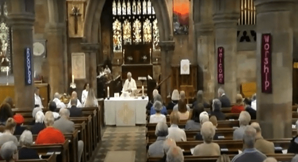
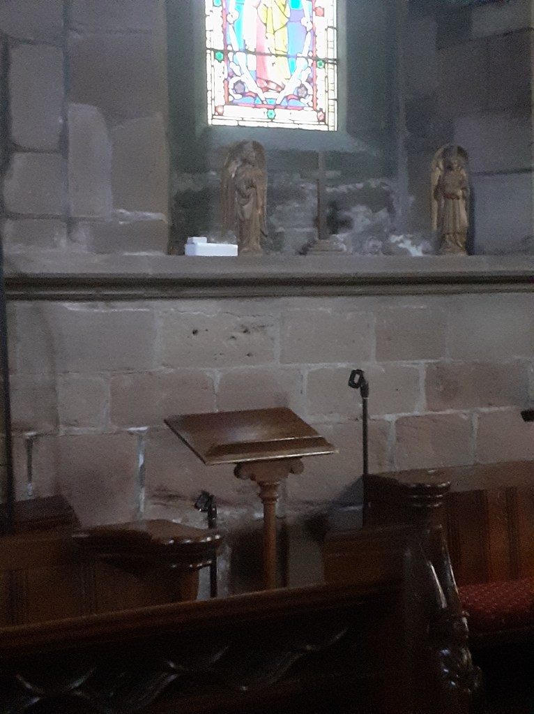


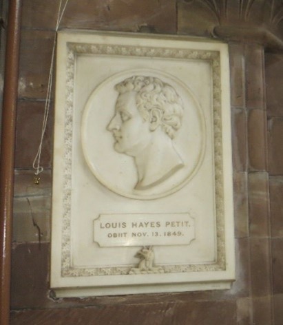

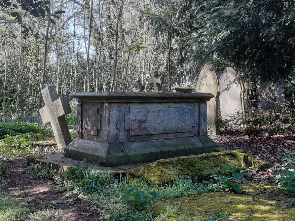
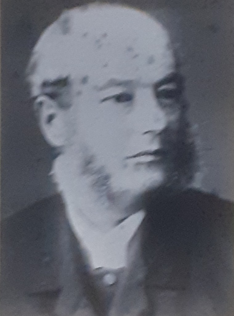


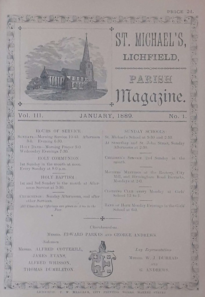
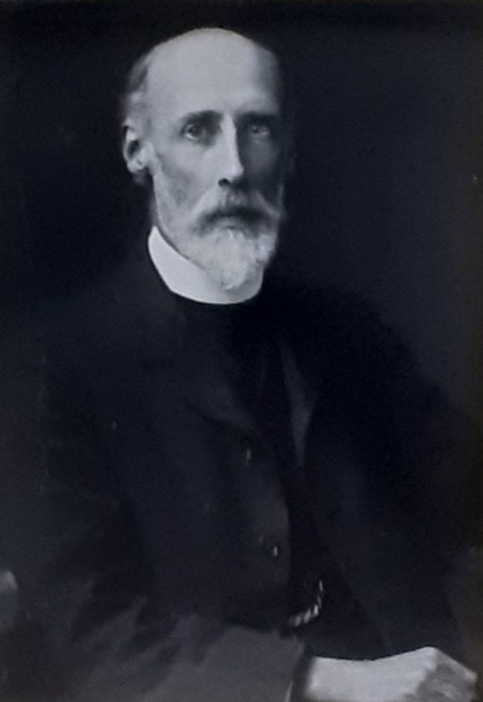
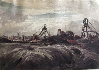
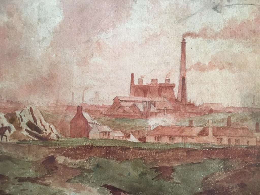

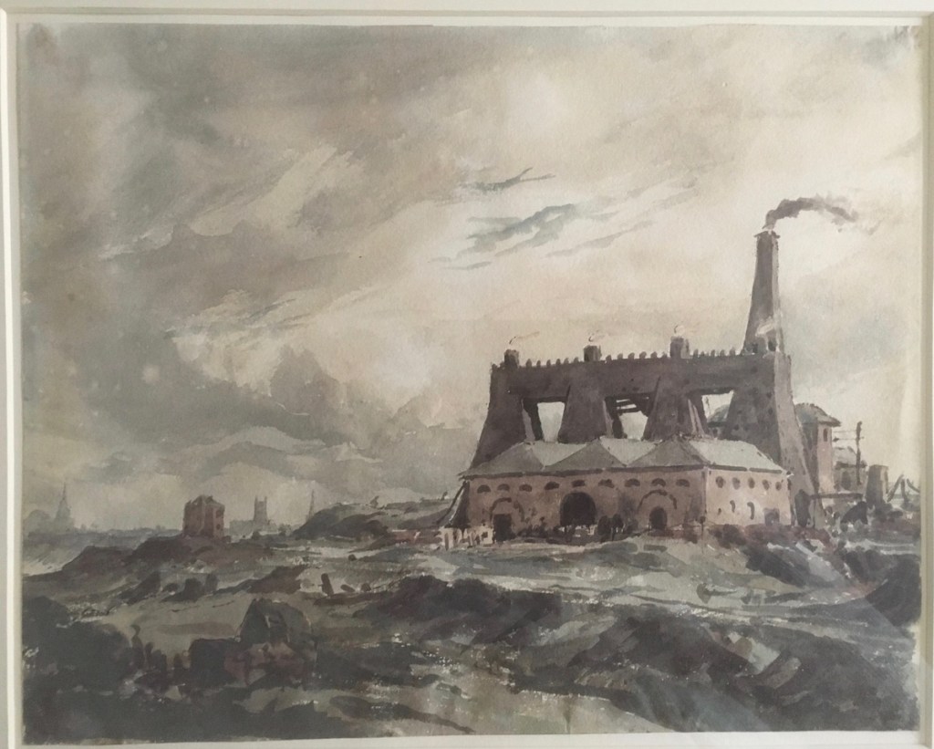


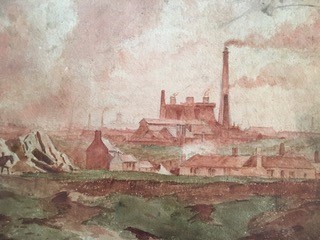


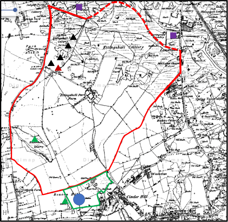
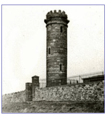


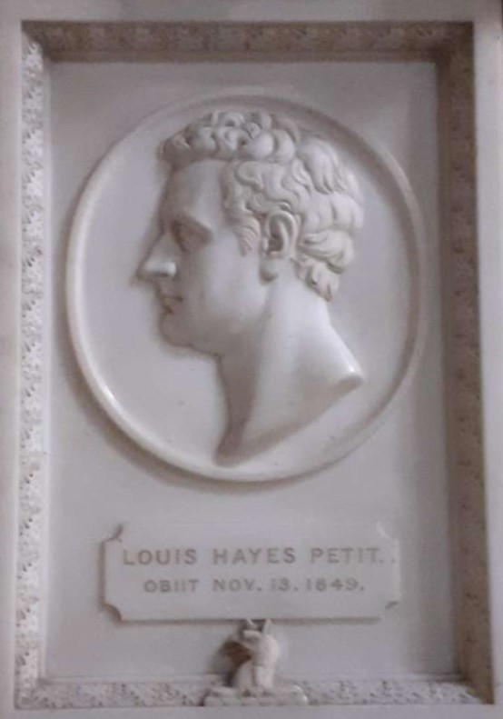
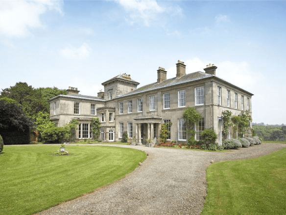
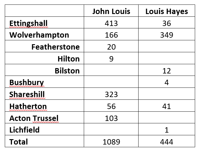


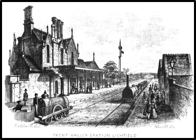


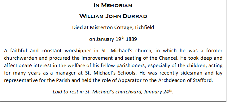
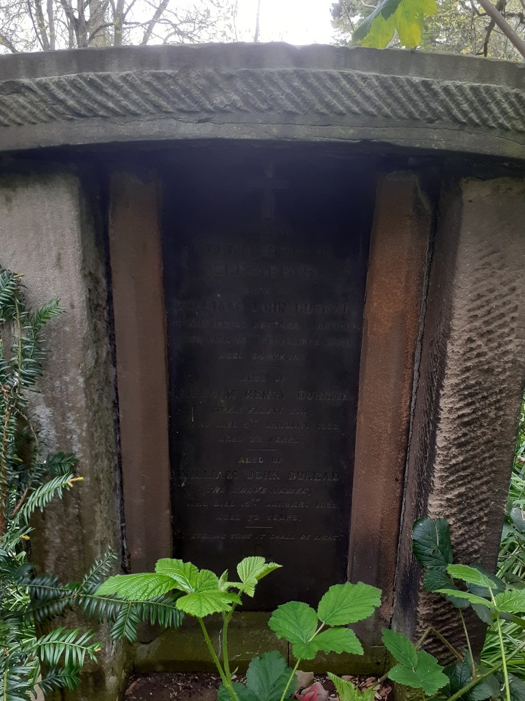
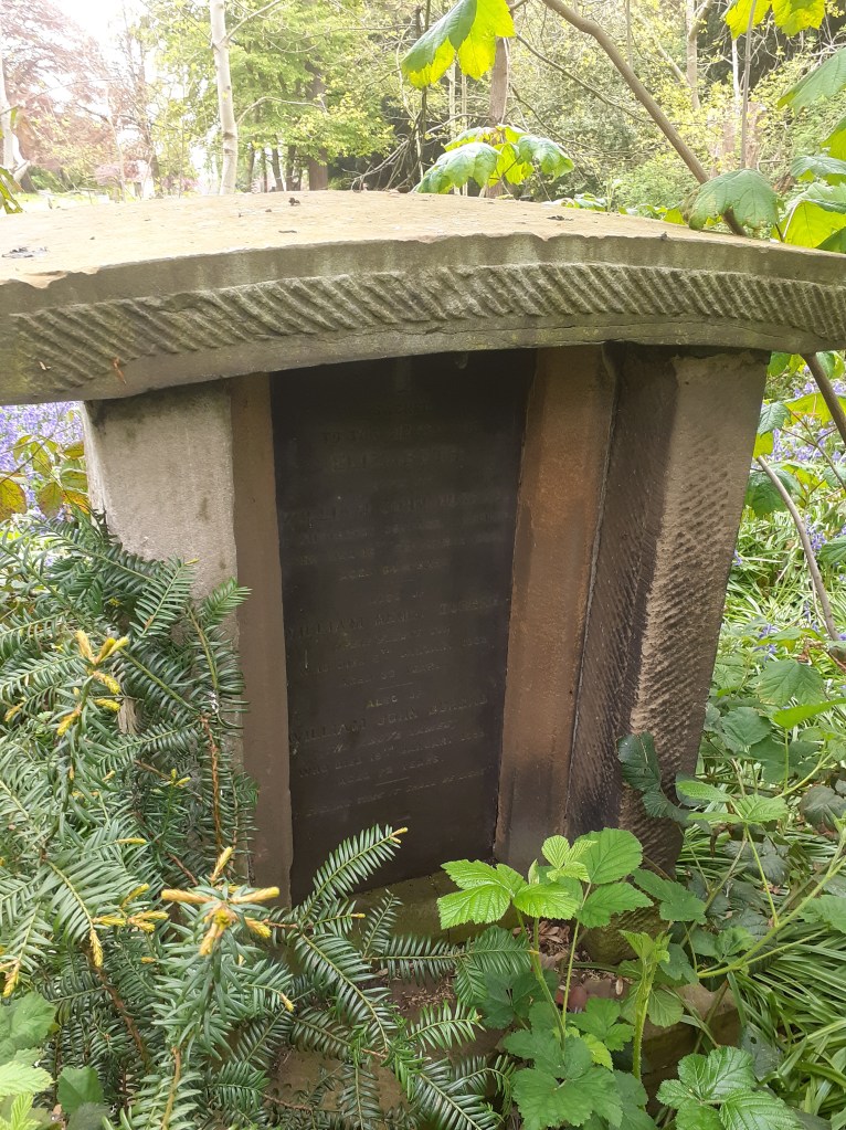
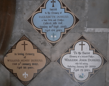


