At some date a silver-gilt chalice and paten of 1684 were acquired. They were sold with a pewter flagon and plates in 1852 to a Birmingham firm in part payment for a new set of plate. The chalice and paten of 1684 were bought the same year by St. Clement’s, Oxford.
Clearly this was later regretted and we read
… attempts in 1892 and 1923 to recover them for St. Michael’s were unsuccessful.
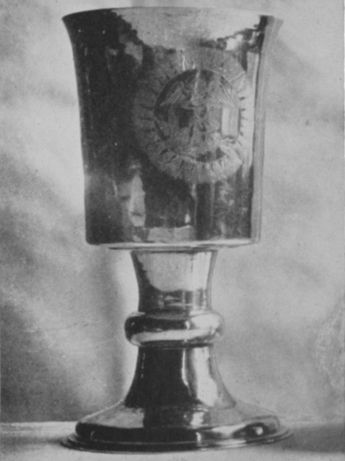
And there I might have left the matter, perhaps as a sort of parable on the foolishness of church wardens, and the futility of the pursuit of modernity, but for the all seeing eye of Google. A quick search of “chalice / St Clements / Oxford” let me to An Inventory of the Historical Monuments in the City of Oxford from 1929 in which I found the rather poor photograph of the 1684 chalice shown below. It is rather fuzzy, but I think the motif is clear enough – the winged archangel trampling over the devil at his feet. I can’t read the caption, so if any reader can enlighten me on this I would be grateful. The question arises as to where the chalice and its associated paten are now. To find the answer to this would I am afraid take more than a quick Google search. Perhaps one day….
In this post we will use the information provided on the Lichfield Tithe maps to investigate the nature of the Cathedral prebends. Until quite recently (in historical terms) members of cathedral staff (prebendaries)were supported by the income from various estates (prebends). In the case of Lichfield, there were basically two types of prebend – the first consisting of estates of various sizes that were leased for farming, industrial or residential purposes; and the second consisting of the income from specific ecclesiastical foundations. The system is well described in the Lichfield Cathedral section of the Victoria County History. At the peak of the prebendal system, Lichfield had 32 prebends, most of which were held by clergy who were only required to be in Lichfield for a few months a year. Twenty four these were of the second type, based on the income from various churches in the diocese and eight of the first type based around specific land allocations. It is thought that five of these – the prebends of Freeford, Handsacre, Longdon, Statfold and Weeford were actually the estates that supported the five canons of Lichfield mentioned in the Domedasy book. Since the prebends are named after areas around Lichfield, it seems reasonable to assume that they consisted of specific areas around the city. Now for many of the properties that are listed, the tithe maps give an indication of which prebend they were in in the middle of the nineteenth century, and thus offer the possibility of mapping these prebends in more detail than has been previously possible. In what follows, we will thus attempt to do this, and it will be seen that it offers a description of the Anglo-Saxon geography of the area that is quite distinct from the later geography. It must however be stressed that what the Tithe maps show is the outcome of many hundred years of land sales, exchanges and re-organisations and thus absolute clarity on the original extent of the prebends is not to be expected.
Lichfield from Domesday to the Reformation
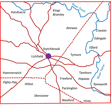
Figure 1. Lichfield and the surrounding area
(blue indicates rivers; solid brown lines indicate early, possibly Iron Age roads and trackways that survived to the present time, and dotted brown lines indicate Roman roads)
Figure 1 above shows the area around Lichfield, with the Rivers Tame and Trent and the early road system identified in the topographical studies of Stephen Bassett, that I have briefly described in an earlier post. The names shown in regular type are the members of the Manor of Lichfield given in Domesday that lie in the vicinity of the city itself, and those in italic type are places that occur in other Domesday entries. It can be seen that the extent of the Manor was large stretching west to Hammerwich and east to the Tame at Tamhorn. There are some obvious gaps on the map – for example around Longdon to the west and Whittington to the east. There are also names not included on the map as their location cannot be identified – Horton, Burweston and Littlebeech. The important thing to observe from the perspective of the current investigation is that the three ancient prebends that are named on the map – Freeford, Hansacre and Weeford have no special importance over the rest. This suggest that if they are basic building blocks of a geography of the area, then this geography significantly predates Domesday and is very old indeed.
The town of Lichfield was set out by Bishop Roger de Clinton around 1140 and became styled as the Manor of Lichfield in its own right, with the rest of the area taking the title of the Manor of Longdon. Over the following centuries many of the members of the Manor became parishes in their own right (as we shall see below) and Lichfield itself shrank to the region of the what were to become the parishes of St Michael’s, St Mary’s and St Chad’s. Within this area there was no parochial system as such, with pastoral care being on the basis of the prebend. The three churches were staffed by the vicars of the five ancient prebends of Freeford, Handsacre, Longdon, Statfold and Weeford. A vicarage was created for St Mary’s with jurisdiction over the city centre in 1491 with the stipend paid from a number of prebends, with the five ancient prebends contributing the majority of the resource. The parishes of St Michael’s and St Chads came into existence in the seventeenth century, although they remained as perpetual curacies until the nineteenth.
Lichfield Parishes
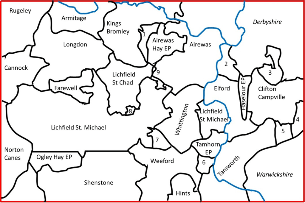
The parishes in the wider area around Lichfield around 1840 are shown in figure 2, drawn with information from The Parish Atlas of England, by Tim Cockin. The three Lichfield parishes can be seen to be of very different sizes, with St Michael’s parish extending a long way to the west at Burntwood, with a detached portion to the east at Fisherwick. St Chads, occupies the northern area of Lichfield, whilst the parish of St Mary and the extra-parochial areas of the Close and the Friary, are very small in comparison. Whilst much of the rest of the area shown in figure 2 is divided into parishes in the normal way, there are a number of extra-parochial areas, often representing areas of former or existing common land such as the Hays at Ogley, Alrewas and Kings Bromley.
Figure 2. Parishes in the Lichfield area around 1840
(1 – Kings Bromly Hay EP; 2- Croxall; 3- Ingale; 4- Thorpe Constantine; 5 – Statfold, 6- Hopwas Hay EP; 7- Freeford EP; 8 – St Mary’s, Lichfield; The Close EP; The Friary EP; 9 – Detached parts of Farewell)
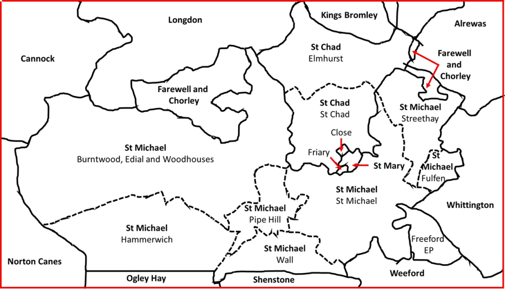
The immediate area around Lichfield is shown at a somewhat larger scale in figure 3. The individual townships in St Michael’s and St Chad’s parishes are shown. It can be seen that the parish of Farewell and Chorley, to the west of St Chad’s parish has detached portions to the east.
Figure 3. Lichfield parishes and townships
The prebends mapped
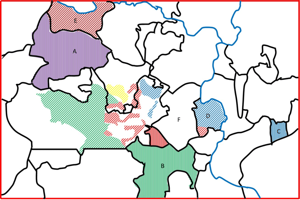
Figure 4. Prebends in the Lichfield parishes
(Letters referred to in text; diagonal stripes indicate prebend to which tithe allocated; vertical stripes indicate region with name of prebend; red – Freeford; green – Weeford; blue – Statfold; yellow – Gaia Major)
The tithe maps give details of the tithes payable for each individual property that they list. Where appropriate they also give an indication of which prebend the tithe is allocated to. The information given varies somewhat in form from parish to parish, and thus we will consider each parish in the area around Lichfield below. We begin by considering the Lichfield parishes themselves in figure 4.
St Michael’s parish, St Michael’s township (A on figure). Here the prebendial split was at its most complex. Figure 4 shows only the regions that can be identified as part of Freeford prebend, which occur across the township, and probably indicates the major underlying land unit. The rest of the area was in the main occupied by land that was allocated to Freeford, Handsacre, Statfold and Weeford jointly, either as part of what is referred to as the Part Pound Tithing, or simply a two or more prebends being allocated tithes jointly. In addition each of these prebends were allocated the tithes from cluster of residential properties close to the city in the Greenhill and St John’s area. There was also a small area where tithes were allocated to the prebends of Bishopshull, Bishops Itchington, Prees and Pipa Minor, but in general the underlying prebend, seems to have been Freeford.
St Michael’s parish, Burntwood, Edial and Woodhouses, Wall and Pipe Hill townships (B, C, D). Almost uniformly the tithes in this area were allocated to Weeford prebend, again with allocations for small residential areas to the other prebends near the city. The large tract of land to the west is indicated on the tithe map as Burntwood Common and no prebend is indicated.
St Michael’s parish, Hammerwich township (E) Tithes in this are allocated to the “Appropriator” – the one to whom the rights to the tithes were sold at some point in the past. No prebends are given.
St Michael’s parish, Streethay township (F). Here the major allocation of tithes is to Statfold prebend (shown on the map), with some small allocations to Bishops Itchington, Curborough and Gaia Minor prebends.
St Michael’s parish, Fulfen township (G). As with Hammerwich, tithes are allocated to an Appropriator in this region.
St Chad’s parish, St Chad’s township (H). Here the situation is again complex. There are large allocations to Freeford and Weeford, together with a large allocation to the prebend of Gaia Major in the central area. There are also smaller allocations to the major prebends in the residential areas, and also small allocations to Bishopshull, Curborough, Gaia Minor and Pipa Minor.
St Chad’s parish, Elmhurst township (I). The tithes of most of the land in this township are allocated to the Mark Part Tithing – jointly between Freeford, Weeford, Handacre, Statfold and Gaia Minor. There are some allocations to Bishopshull, Curborough, Gaia Minor, Handsacre and Pipa Minor prebends in the north.
Freeford extra parochial area (J). There is no tithe map available for this area, but it has been assumed on figure 4 that the entire area here was allocated to Freeford prebend, which does not seem unreasonable.
Figure 5. Prebends in the wider area around Lichfield
(Letters referred to in text; diagonal stripes indicate prebend to which tithe allocated; vertical stripes indicate region with name of prebend; red – Freeford; green – Weeford; blue – Statfold; yellow – Gaia Major; purple – Longdon; brown – Handsacre and Armitage)
Figure 5 shows a rather wider area around Lichfield indicating the situation in the surrounding parishes. The parishes of Longdon (A), Weeford (B) and Statfold (C) have tithes allocated to the vicar of the parish, or to an Appropriator, but are here marked as belonging to Longdon, Weeford or Statfold prebend. The outlying pat of St Michael’s parish at Fisherwick (D) has tithes with discrete areas allocated to Statfold and Freeford prebends. The parish of Aldridge and Hansacre (E) has tithes allocated exclusively to the prebend of Handsacre and Armitage, the successor of the ancient prebend of Handsacre. The tithes of the parish of Whittington (F) are allocated to the prebend of Whittington and Berkswell (the latter being in Stafford), which is a relatively modern prebend. All the other parishes shown have tithes that are allocated to the vicar of the parish, or to an Appropriator. At this point it should be noted that there is a minor discrepancy between the tithe maps and material in the Parish Atlas for Farewell parish. On the tithe maps, the lower arm to the east of the parish is shown to be a detached part of Elmhurst township in St Chad’s parish, with its tithes allocated to Pipa Minor prebend, whilst in the latter it is shown as integrated into Farewell, as shown here.
Discussion
So what of the original premise of this post – can the ancient prebends be said to have well defined territories. I would suggest, on the basis of the maps of figures 4 and 5, the answer is a tentative yes. Let us consider each of the ancient prebends in turn.
The area where the tithes are allocated to Freeford, together with the eponymous hamlet, suggest that the original Freeford estate included most of St Michael’s township and part of St Chad’s and probably the city centre parish of St Mary as well. To the east it included Freeford, part of Whittington, the southern part of Fisherwick and perhaps extended to the river Tame through Tamhorn.
The territorial extent of Weeford prebend was very large, assuming that the later parish of Weeford was included within it. As well as the parish, it included the eastern part of Brownhills, Edial and Woodhouses township, Pipe Hill township and Wall township, as well as a small part of St Chad’s parish. It also possibly contained the Hammerwich area and the parish of Hints. Figures 4 and 5 suggest that part of Shenstone parish would probably have been included as well in order to make the eastern and western portions more of a coherent whole. If that were the case it would have been centred on Wall, the oldest settlement in the area at the junction of the Roman roads. In total it formed a wide arc around the southern and western edges of the city.
Statfold prebend extended from Streethay township in the west, through Whittington and the northern part of Fisherwick, and presumably to the parish of Statfold itself in the east. If it formed a coherent connected estate, it would have to have included parts of Elford and Clifton Campville parishes, for which there is no evidence.
The situation with respect to the two western prebends of Longdon and Handsacre is complex, probably because of the early formation of Longdon parish, and its role as the centre of the manor after the setting out of the town by Bishop Clinton. From figures 4 and 5 it can tentatively be suggested that it included Longdon parish itself, Farewell and Chorley parish, Elmhurst township and perhaps the area in St Chad’s parish allocated to Gaia Major. The latter could as easily be part of Weeford or Freeford prebends.
Handsacre prebend obviously included the later parish of Armitage and Handsacre in its entirety. If it ever extended closer to the city, it would have needed to include at least part of Kings Bromley parish and perhaps Elmhurst township too. There is no indication that this was ever the case. Geographically the parish boundaries suggest it may once have been associated with Longdon and perhaps represents and early division of the prebends in the Anglo Saxon era.
So what then might be the implications of this study? It points to an early Anglo-Saxon subdivision of the area around Lichfield into a small number of large divisions. One of these, that later bore the name Weeford, was probably centred on Wall and was thus a territory associated with the Roman settlement of Letocetum. Another, Freeford, seems to have embraced the location of the current city centre and extended eastwards a considerable direction. The -ford in Freeford has been taken to refer to the rather inconsequential ford over a brook close to the current Freeford House. If one accepts that Freeford originally encompassed the city centre, then the ford referred to might be the more substantial one that would have crossed the Leomansley Brook in the region of the current Minster pool.
A comparison of the prebend areas with the road system shown in figure 1 is of interest. Basically each of the prebends is connected with the centre of Lichfield via an ancient road – Freeford via the road that is now the Tamworth Rd, Weeford by the London Road and the Roman road network, Longdon by the Stafford Road and Hansacre by the road to Rugely. Statfold is connected by the road that enters the city via Darnford Lane and Boley Cottagee lane. If this extended all the way to Statfold, its route east of Whittington is however not clear. The prebends thus form a well-connected network with easy access to the central area.
I have argued elsewhere, based in the main on place name studies, that the Lichfield area was a centre of pre-Christian pagan worship, and that the ancient prebends played a significant role in this. The current work does nothing to counter such a proposal, and perhaps, by showing the extent of the prebends tends to confirm it.
Although it might sound rather odd to many, when I learnt that Staffordshire Records Office had put digitized versions of the county tithe maps on line, together with all the records to which they refer, I was immensely excited. No doubt this says something about my rather odd personality, but having this material easily available opens up a whole range of possibilities for research. In the blogs that may follow over the coming months I will thus present the results of my investigations of the tithe maps of Lichfield – considering land ownership and occupation, urban land use, the tithe recipients and the extent of the prebends (the old cathedral estates) in the city and the surrounding area.
But first in this post some words of introduction. The tithe maps are available at the Staffordshire Past Track web site and cover the whole of the county. The site briefly describes the maps as follows.
The tithe apportionment awards and maps held by the Archive Service stem from the Tithe Commutation Act of 1836, which replaced the payment of tithes as one tenth of agricultural produce (grain, hay, calves, lambs, etc.) with a rent charge apportioned between the landowners in the parish or township. Initially, owners of land and tithes could voluntarily agree a sum, but after October 1838, compulsory commutation began. Maps were drawn up and detailed schedules called ‘awards’, listing owners, occupiers and property details for each individual plot were created. Most processes were completed by 1845.About 70% of the land area of the county was subject to tithe at this time. Exceptions were where tithes had already been commuted or extinguished, for example as part of an enclosure award. In some cases, tithe had never been paid – on former monastic land, or on land which was too poor in the medieval period to have been titheable, such as parts of the Staffordshire Moorlands.
In addition to the maps, the database contains the following information. – document reference; owner surname and forename(s); occupier surname and forename(s; )township and parish; plot name and plot number; land use; area (in acres, rods and perches); tithers payable; value(s) and notes.
I have concentrated particularly on the Lichfield area in my investigations so far. On the tithe maps Lichfield consisted of three parishes – St Mary’s in the city centre; St Chad’s to the north and east, and St Michael’s in the south and west. St Chad’s was further divided into two townships – St Chad’s itself closest to the city centre, and Elmhurst and Curborough to the north. St Michael’s parish was huge and consisted of the townships of St Michael’s itself, to the east and south of the city centre; the township of Burntwood, Edial, Woodhouses, Pipe Hill and Wall to the south west; the township of Hammerwich west of Burntwood; the township of Streethay to the north east and the detached township of Fisherwick to the east beyond Whittington. In addition there were a number of extra parochial areas – the Close, the Friary, Freeford and Fulfen. Tithe information is only available for the last of these. The dates of the individual maps are given in the table below.
These dates are actually quite significant, as they cover the period when new parishes were being formed from the old. Burntwood and Wall became separate parishes in 1845. Christchurch parish was formed from parts of St Michael’s and St Chad’s parish in 1848. The nature of Hammerwich parish at the time is not totally clear, as there was some dispute between its residents and St Michael’s, but it was functioning as a separate parish by the early 1840s. Thus the tithe maps largely represent the situation in the early 1840s in terms of designation of townships, and the classification used on the maps will be adopted in what follows.
My method of working has been to copy and paste all the individual records for the Lichfield area into several spreadsheets (an unbelievably tedious task) and then through some fairly simple programming to get all the records onto one line in the spreadsheet, with the items listed above in individual columns. This then gives the possibility of ordering the records by different columns, searching for multiple entries and so on.
Whilst the information on the tithe maps can be used to paint a detailed picture of life in the Lichfield area in the 1840s, and I may well do so in later posts, in the next post I will use this information to see what the tither maps can tell us about a much deeper past – the nature of the early, pre-conquest prebendial estates of Lichfield Cathedral It will be seen that this throws a whole new light on the early geography of the area.
The baptismal and burial registers allow the residence of the parents of the baptized child and those who have died to be identified, at least in broad terms. Neither measure can be regarded as an accurate measure of population, as the same couple may well figure more than once in the baptismal registers, and those who have died may not be long term residents of the parish. To investigate how this population is dispersed across the parish, we define the following districts.
Within the parish throughout the study period
Greenhill – the dense urban area close to St Michael’s church that extended up Burton Old Road and Trent Valley Road as the century progressed, together with its rural hinterland, broadly covering the area of the current Boley Park Estate.
St. Johns – based on the urban area around St. Johns Street (including, and south of St John’s Hospital) and the Birmingham Road, stretching south to the canal, with its rural hinterland in the Borrowcop and Berry Hill area. Note that the St. John’s and Greenhill as defined here did not have a direct road connection between their major centres for much of the study period, with journeys between them requiring a passage through St. Mary’s parish.
The Workhouse on Trent Valley Road (the later St. Michael’s hospital).
The hamlet of Streethay to the north of the parish, including the development in the second half of the century of much railway activity around Trent Valley Station.
The rural hamlets of Freeford and Fulfen to the east of the parish.
The out of parish townships
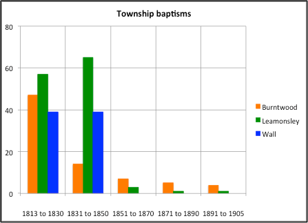
Burntwood, together with Edial and Woodhouses, which became a separate parish in 1820 with the opening of Christchurch, Burntwood.
Wall, which became a separate parish in 1845 following the opening of St. John’s Church in 1843.
Leamonsley to the west of the city which, with Pipe Hill, became the parish of Christchurch, Lichfield in 1848.
Out of parish districts
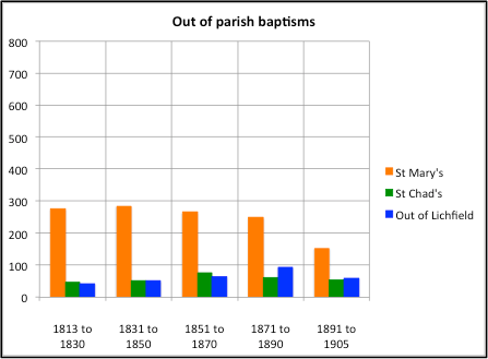
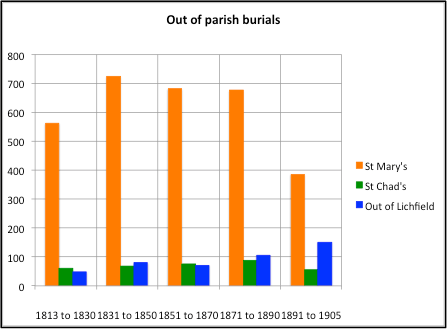
The parish of St. Mary Lichfield, including the extra-parochial areas of The Close and The Friary.
The parish of St. Chad, Lichfield
Any other out of parish location outside Lichfield.
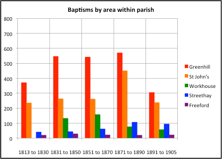
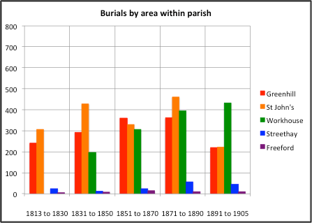
Figures 6 below shows the baptisms (on the left hand side) and burials (on the right hand side) for each of these three categories. These graphs show actual baptism numbers in (nominally) 20 year periods, rather than the number of baptisms per year. Note again that the first and last periods are somewhat shorter than 20 years.
Consider first the baptisms and burials in the different areas of the parish itself. For the former, the largest contributing area is Greenhill, with St. John’s the second largest. The situation is reversed for burials, perhaps indicating a rather younger population in the Greenhill area. The Workhouse baptisms and burials begin in the 1831 to 1850 period, as the Workhouse opened in 1840. In general the number of baptisms decrease with time, while the number of burials increase markedly, until in the period from 1891 to 1905 they are the single biggest number of burials. Both baptisms and burials increase over the century in Streethay, reflecting the growth of railway based activities there, whilst the figures fro the rural area of Freeford / Fulfen remain small and constant.
The township baptisms and burials show a major fall after the chapels in the respective area are opened – 1820 for Burntwood, 1845 for Wall and 1848 for Leamonsley. The baptism figures fall more dramatically than the funeral figures, suggesting that a number of township residents wished to be buried in family graves at St. Michael’s.
The out of parish baptisms and burials are interesting. There can be seen to be significant cross boundary baptisms of parishioners from St. Mary’s and St. Chad’s parish, presumably because of family or other historical connections. The number of burials for St. Mary’s parish was however very large, due to the fact that there was no graveyard there. This imposed a considerable load on the clergy at St Michael’s (as will be seen below), In 1886 the Vicar of St. Mary’s agreed to conduct the funerals of his parishioners in St. Michael’s churchyard, but he stressed that by ancient custom it was the duty of St. Michael’s clergy to do this. A somewhat grudging agreement it would seem. From 1888 an annual collection was taken at St. Mary’s for the upkeep of the churchyard. Both these developments probably reflect a grievance extending over several decades that St. Michael’s clergy were providing unpaid services to St. Mary’s parish. The out of Lichfield category includes baptisms for families from the towns and villages surrounding the city, but also significant number from further afield – in particular from Birmingham and London – probably because of historic or family connections.
Figure 6. Baptism and burial statistics by areas of residence
Finally the registers reveal the existence of some interesting groups of people in the population for whom a more in-depth study might be appropriate – the soldiers from the Militia Barracks in the Sandford Street area; the canal workers and boatmen on the Lichfield and Hathersage Canal and the wharfs in the St. John’s area; a huge community of coachmakers, coachmen, horsemen etc. connected with the coach routes through the city, and, in the second half of the century the railway workers on the London North Western Railway through Trent Valley and the South Staffordshire Railway through Lichfield City.
Analysis of Christian names
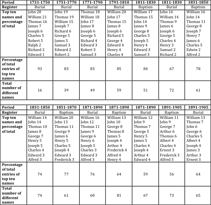
Both the baptismal and burial registers can be used to study how the Christian names of those in the parish varied over time. Whilst this might seem a somewhat trivial analysis, it does reveal something of changing attitudes and perceptions over time. From the baptismal registers, the information is directly available on a year-by-year basis. Extracting dated information from the burial registers is a little more tricky and requires the birth year to be calculated from the death year and the age at death. Even if the names are all related to the birth year, one might expect some differences – the baptismal registers will, in general, refer to those who were born in the Lichfield area, the burial registers will contain entries relating to those who were born elsewhere. Similarly the latter are more likely to indicate the preferred name of the deceased – be it first name, middle name or by-name. These points being made, details of the names over a period of around 180 years are given in table 1 for men and table 2 for women. Each table shows the following information, for the usual nominal twenty-year periods.
The most popular ten names in that period and the percentage of the total number of register entries for each of these.
The percentage of the total number of register entries that are accounted for by these top ten names.
The number of different names used in the period.
For both male and female names the following broad conclusions can be drawn.
The most popular names remain pretty much the same over most of the period studied.
For the earlier periods in the 18th century the top 10 names account for 80 to 90 % of all names. This figure falls throughout the 19thcentury to around 60% for male names and 35% for female names.
Over the same period the number of different names increases by a factor of four.
Female names were always more variable than male names.
The most popular male names (William, John and Thomas) each account for about 20% of all entries in the early periods, falling to around 6 to 12% in the late 19thcentury. Similarly the most popular female names (Elizabeth, Mary and Sarah) account for around 15 to 20% of all entries in the earlier periods, falling to around just 3% in the late 19thcentury.
Two points arise from this study. The first is that the increasing number of names in use possibly reflects the movement from a very conservative society (at least in terms of names) to one with a wider outlook. Indeed, some of the minor names not shown in the table are quite outlandish and unconventional, particularly for the female names – for example Rosetta, Vanda and Pretoria. Secondly, in their conservatism the most popular names are very similar to those outlined in two other studies that I have carried out for the western region of the Black Country – for the parish of Kingswinfordin 1822 and 1840, and for the members of the Shut End Chapel in Pensnett from 1840 to 1890. The general population for these two studies was again composed of unskilled and skilled manual workers, and were thus similar o the population make up of St. Michael’s parish in the 19thcentury.
Table 1. Analysis of male Christian names
Table 2. Analysis of female Christian names
Ministers and Church
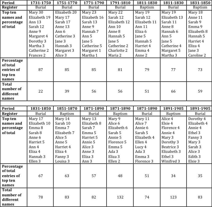
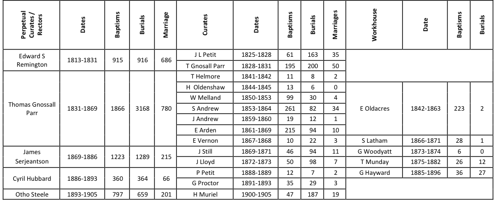
Table 3 below shows the Perpetual Curates (Rectors from 1868) at St. Michael’s, their curates or assistants, and the chaplains of the Workhouse in the period we are considering, together with the absolute numbers of baptisms, marriages and funerals they carried out. The longevity of the ministers in charge is notable, with only three perpetual curates / rectors from 1813 to 1886. The first of these, Edward Remington, was actually the brother of an earlier Perpetual Curate at St Michael’s and the son of another, the dynasty extending back to 1757. His early career included Perpetual Curacies at St Chad’s Lichfield and Pipe Ridware, before coming to St Michael’s in 1805. In 1820, he was, in addition to St. Michael’s, instituted as Curate at Burntwood, when Burntwood itself achieved parochial status. As Perpetual Curate of St. Michael’s he would already have had oversight of Burntwood, but it seems he was formally designated its first incumbent, at least for a short period until 1828. From 1829 to 1831 he was also Vicar at Wirksworth in Derbyshire. How he managed these two rather far-flung parishes is not clear, but doubtless he utilized the services of his curates.
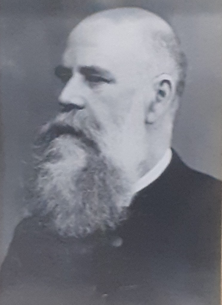
Thomas Gnossall ParrJames SergeantsonCyril HubberdOtho SteeleThe 19th century Rectors
One of these curates was Thomas Gnossall Parr, who held that post at St. Michael’s from 1828 to Remington’s death in 1831. He was then appointed Perpetual Curate, a post he held for 37 years before becoming the first Rector in 1868, one year before his death. He was born in 1800, the son of another Thomas Gnossall Parr, a Lichfield solicitor, and remained umarried. In 1861 he was living at the Parsonage House on Mount Pleasant with his sister Anne, and a single servant. The number of baptisms, marriages and funerals conducted by Remington and Gnossall Parr was eye-watering – the largest number in the table being the 3168 funerals conducted by the latter. Whist they were assisted by a string of curates, they still seems to have carried most of the load themselves.
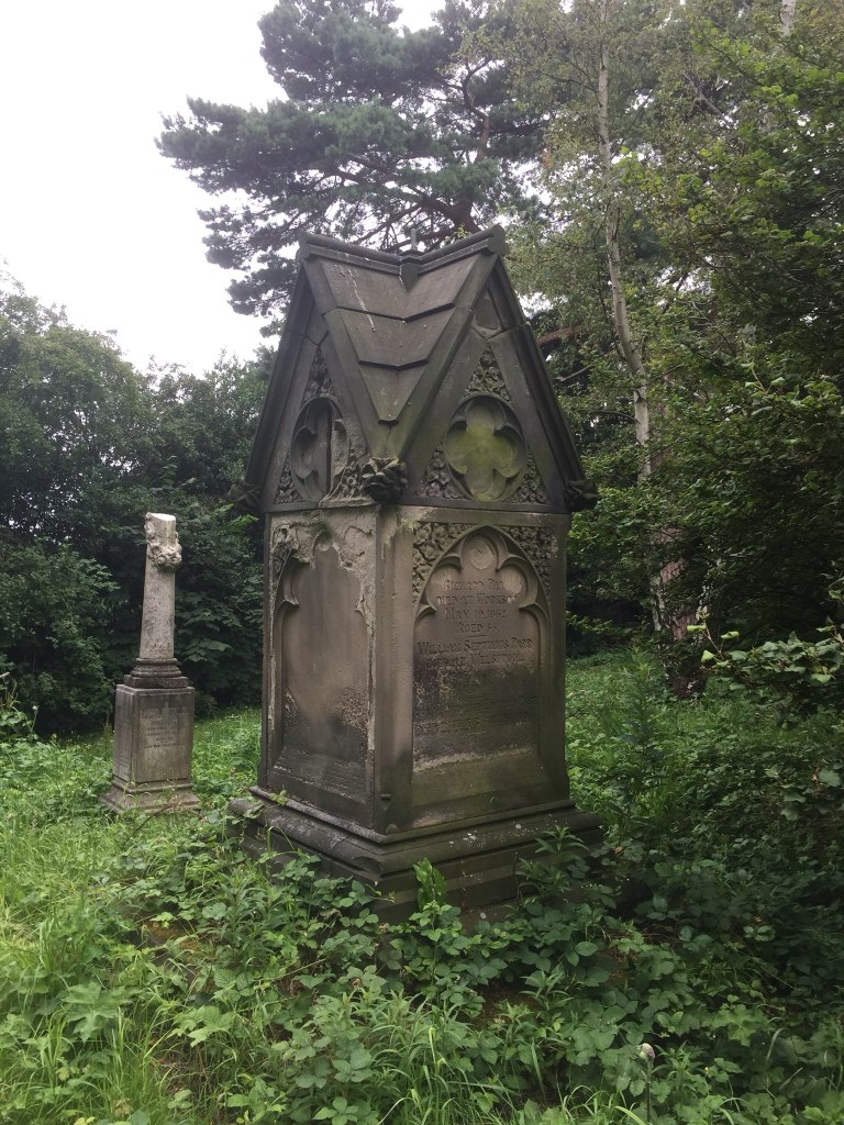
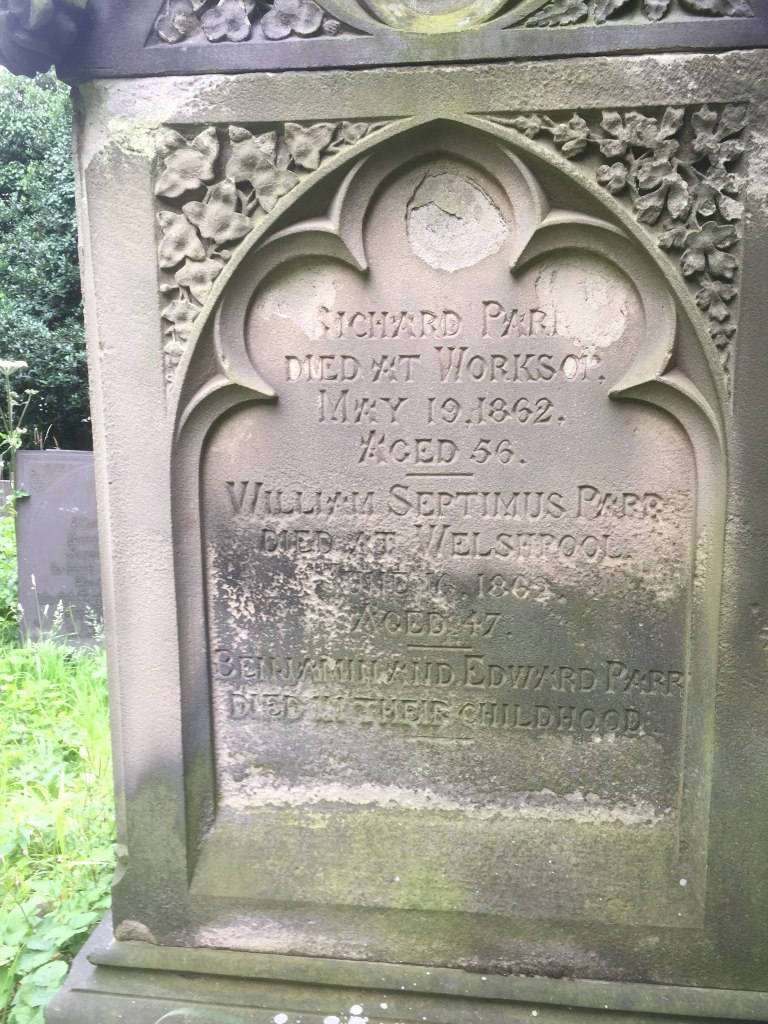
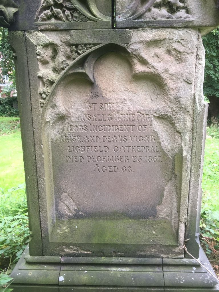
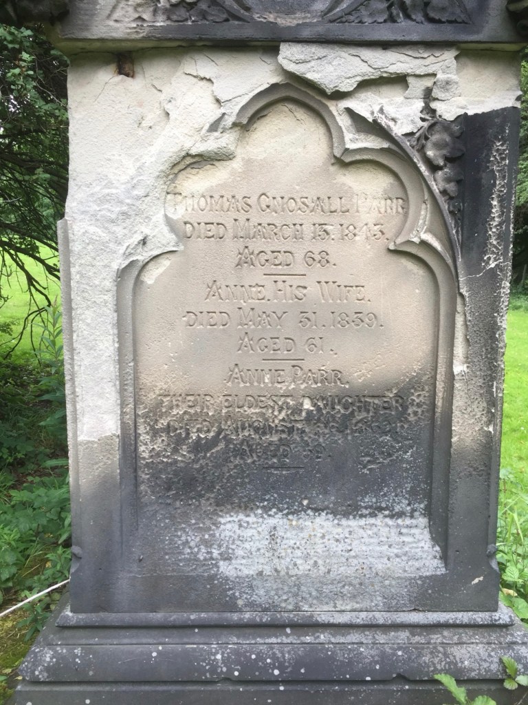
The grave memorialParr family membersThomas Gnossall ParrThomas Parr Senior and his wifeThe Parr grave in St Michael’s churchyard
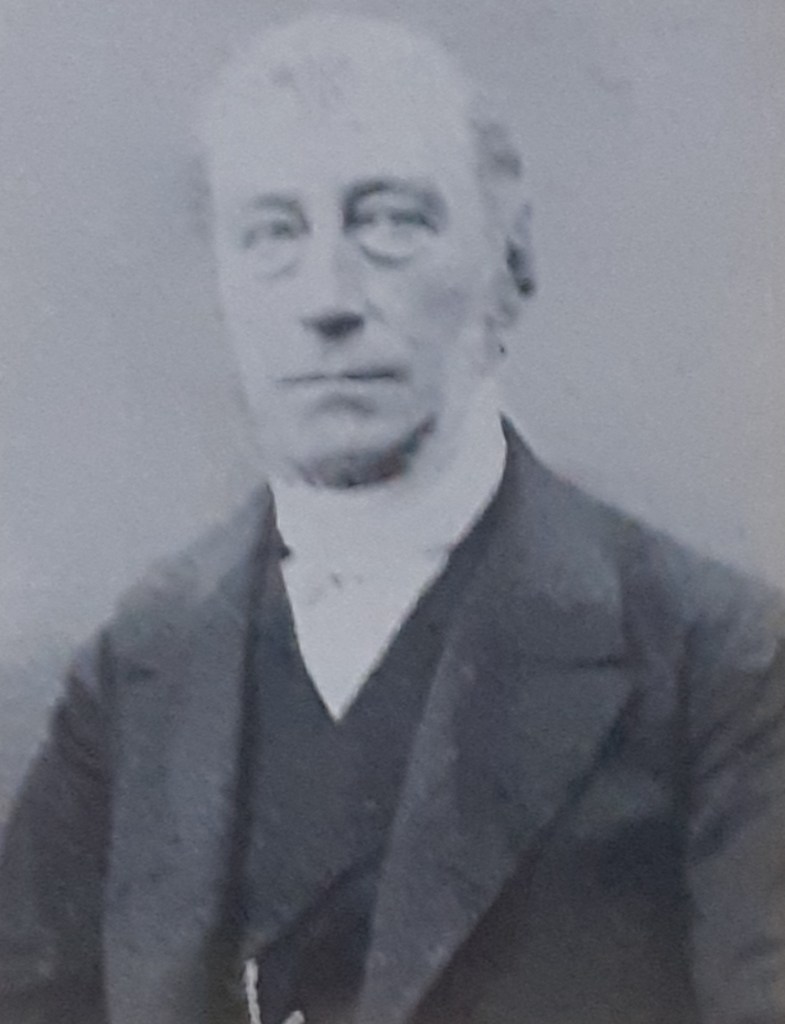
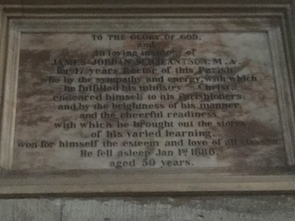
The first clergyman to be appointed Rector, James Sergeantson, was from Liverpool and educated at Trinity College in Cambridge. He was a rowing blue and part of the crew that lost the boat race in 1857 by 11 lengths. There have only been six larger losing margins in the 190 year history of the race, so I doubt it was an experience he relished. He served a curacy at Stoke before coming to St Michael’s. He was married to Elizabeth, a clergyman’s daughter and they had at least 5 children. In 1881 they lived at the Rectory, with a housekeeper, cook and two servants. He is recorded on a memorial in the church as being part of the team that rang a complete peal of Gransire Minor in 1876. He died in 1886. A memorial plaque in the chancel at St. Michael’s reads
To the glory of God and in loving memory of James Jordan Sergeantson M.A. for 17 years rector of this parish….. He fell asleep January 1st1886 aged 50 years.
The Serjeantson Memorial
Sergeantson was followed by Cyril Hubberd, an old Etonian who graduated from St. John’s College Cambridge, and served in parishes in the south of England before coming to St. Michael’s. In 1891 he lived at the Rectory with his wife Agnes, their two children, a cook, a nursemaid and two housemaids. In 1886 he secured an arrangement, albeit somewhat grudging, with the Vicar of Mary’s who agreed to conduct the St. Mary’s funerals, although more often than not, this resulted in the St. Mary’s curates carrying out the duty on his behalf. When Hubbard left St Michael’s in 1893, he moved to the south of England and out of parish ministry. Perhaps St. Michael’s was too much for him. He is however recorded as a Chaplain in various European cities in the 1900s.
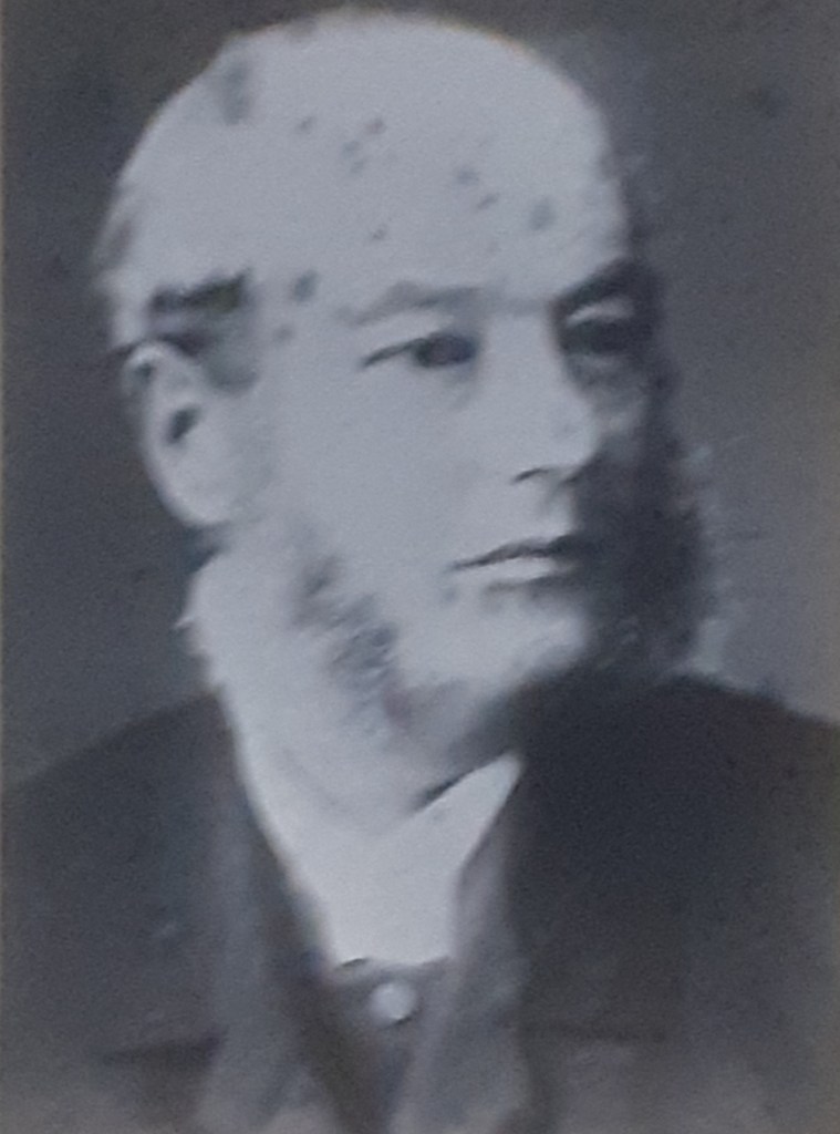
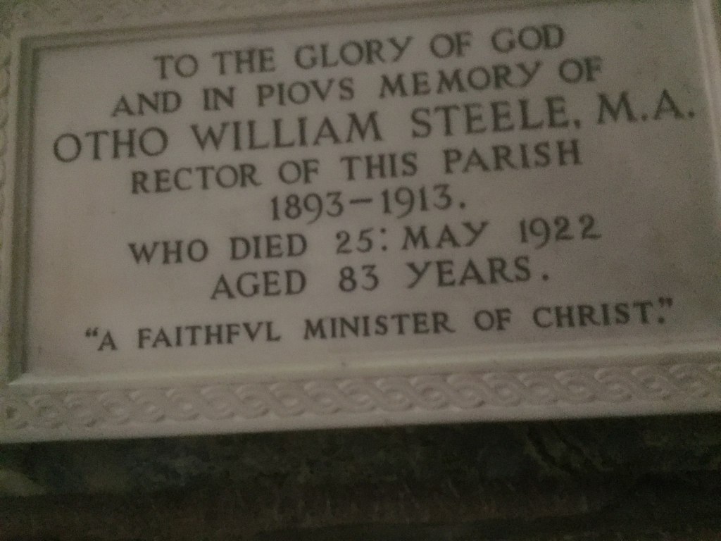
The last of the 19thcentury rectors was Otho Steele. He was born in the 1839, educated at Trinity College Dublin, and served in parishes in the east of England, Guernsey and Stoke before coming to St Michael’s in 1893. He remained there till 1913, and died in 1922. Again there is a memorial plaque in the chancel that reads as follows.
To the glory of God and in pious memory of Otho William Steel, M.A. Rector of this parish from 1893 to 1913 who dies 25thMay 1922 aged 83 years.
The Steele Memorial
The situation with regard to the Workhouse was interesting. The chaplains of the Workhouse conducted baptisms there, but these were recorded in the St. Michael’s register. However, up to the 1880s, all the funerals were conducted by St. Michael’s clergy. After that there seems to have been some overlap at that time with some of the curates at St. Michaels also acting as Workhouse Chaplains.
Closing comments
The registers also indicate that a not-insignificant number of services were conducted by either visiting clergy (presumably at the family request) or by other clergy in the locality, to cover absence and holidays no doubt. The funerals of the residents at St. John’s hospital were usually conducted by the Master of the Hospital. In the early part of the century, the burials were actually in the grounds of St. John’s, with the burials registered in the St. Michael’s register, but later internments were in St. Michael’s graveyard.
Table 3. Rectors, curates and chaplains
This post has presented what at first sight is a rather detailed technical examination of manuscripts. However it does reveal some quite fascinating details of the development of St. Michael’s parish over the 19thcentury. It was basically the parish of the lower and middle classes of the area, with very few of those at the top of Lichfield society. We see clearly a significant decrease in childhood mortality in this group over that period, and the huge risk of childbirth to women is all too clearly seen. The rise of basic literacy can also be seen from the signatures in the marriage registers. The development of the different areas of the parish can be traced in terms of a growing population and a widening of residential areas, with the increasing numbers of those within the Workhouse a reminder that such growth does not benefit all level of society. The analysis of Christian names sees an essentially conservative use of a small sub-set of names develop into a much wider use of a wide range of names, perhaps reflecting the growing horizons of the population. In ecclesiastical terms, the effect of the outlying townships becoming parishes in their own right is apparent, and the interactions between the city centre parishes is very clear – as are the reasons for the disagreement over funerals and burials between St. Michael’s and St. Mary’s.
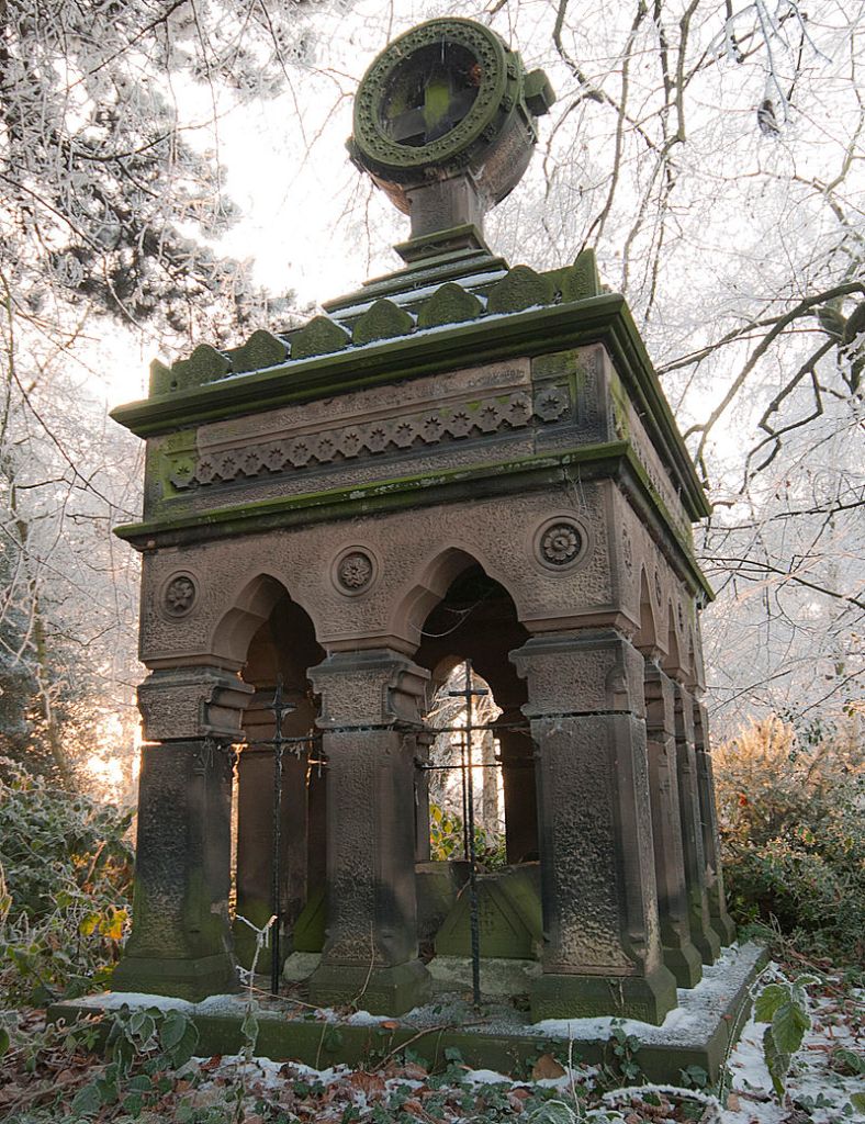
But there is much more that could be said of course about some of the many individuals who feature in the registers – for example Rev John Louis Petit, the curate from 1825 to 1828 and a noted landscape painter, James Law, the Chancellor of the diocese, whose Mausoleum still dominates the front of the churchyard (see below), John Brown, who sounded the trumpet at the charge of the Light Brigade, and many others from long term Lichfield families.
There is of course further work that could be done of this type. Perhaps the most obvious extension would be to do the same sort of analysis for the registers of St. Mary’s and St. Chad’s as the three churches obviously have significant interaction. This would be quite possible as for the period covered in this blog the registers are again available in .rtf format that can be manipulated in spreadsheets. Maybe one day in the near future I will summon up the energy to do this.
The second extension, that would require more work, would be the integration of the current work with other datasets – and in particular the census returns and the St Michael’s Monumental Inscriptions. Whilst the data is available, the actual task of correlation and assessment would be very significant. Maybe in a year or so.
Finally the work could be extended to look at earlier time periods – but here the registers are not in the same convenient format, and to make them so, at least from the publically available databases would be a huge task. Maybe in another life.
A few years ago, whilst looking at some maps of the Lichfield area where I live, I was struck by the overall southwest / northeast alignment of the city, and wondered if this might hide some sort of topographical alignment based on midsummer sunrise (in the northeast) and midwinter sunset (in the southwest). The fact that the bronze-age ceremonial centre at Catholme was to the northeast of the city encouraged me in these views. Now seeing alignments of any sort from maps isn’t terribly well regarded by serious historians – those somewhat idiosyncratic types who spend their lives looking for “lay lines” connecting monuments of different types have rather made this sort of speculation somewhat less than respectable. And there is some cause for this suspicion, as alignments of different sorts can be found almost anywhere should one look hard enough. For instance I noted a few years ago that Borrowcop Gazebo, Lichfield Cathedral and Rugeley Power station were lined up very nicely, which I suspect doesn’t have much historical significance. But nonetheless these thoughts have stayed with me, and given that during the current lockdown situation I have time on my hands, I thought I would investigate this a little further. This blog post is the result. In the next section I outline how the directions of summer sunrise and winter sunset can be accurately calculated using some simple maths (readers who don’t like that sort of thing may care to pass over this section quickly). I then identify a possible midwinter sunset alignment from Catholme. Finally I speculate on what might be the implications of such an alignment,
Calculating solar alignments
Wood (1978) gives the following simple formula for calculating the azimuth (degrees from north) of the midsummer sunrise midwinter sunset
The site latitude is easily determined from geographical data. The elevation is the angle from the point of observation to the horizon over which the sun will set, corrected for the curvature of the earth and atmospheric refraction. The actual angle is easily obtainable from software such as Google Earth, and Wood (1978) gives values for the two corrections. The declination is the angle between the plane of the celestial equator and the terrestrial equator. The values of this angle for the midsummer sunrise and midwinter sunset have the same magnitude but different signs. The declination also varies with time, so the values from 4000 years ago differ from current values by about 0.6 degrees. This is quite important for the calculation and needs to be specified by a historically reasonable time being specified for the alignment in question.
The Catholme alignment
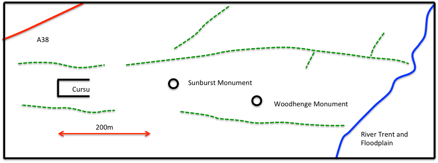
The first step in identifying whether or not there is a possible solar alignment is to identify the end points of such an alignment. So we begin with Catholme itself. The ceremonial complex is shown in figure 1. Essentially there are three monuments within the complex – a cursus dated to around 3000BC; a sunburst monument due east of the cursus, characterised by post holes radiating from the centre, and a Woohenge monument, characterised by concentric circles of post holes, to the east of the sunburst monument and slightly to the south. The Sunburst and Woodhenge monuments have been dated to between 2600 and 2400BC and remained in use for several centuries. There thus seem to be three possible starting points for the alignments, at each of the three monuments.
Figure 1 Sketch of the Catholme complex (Chapman et al, 2010)
But what of the other end of the alignment? In the first instance I expected this to be in the Lichfield area, but a study of the topography profiles (using Google Earth) on a south-westerly line from Catholme through Lichfield shows that Lichfield lies in a hollow and can’t be seen from Catholme. Also the horizon from Catholme is well beyond Lichfield in the Walsall Wood / Pelsall area. An investigation of maps of this area however revealed a very suitable location in Castlebanks (the site of an Iron Age Hill fort), a prominent hilltop that would have been on the horizon from Catholme and would act as a natural marker for observing the setting of the sun.
So as a first step, I calculated the directions from the three Catholme monuments to Catlebanks, simply using the longitude and latitude values for each of the sites. These are as follows, with direction measured clockwise from north.
Cursus to Castlebanks 225.7 degrees
Sunburst monument to Castlebanks 226.4 degrees
Woodhenge monument to Castlebanks 227.4 degrees
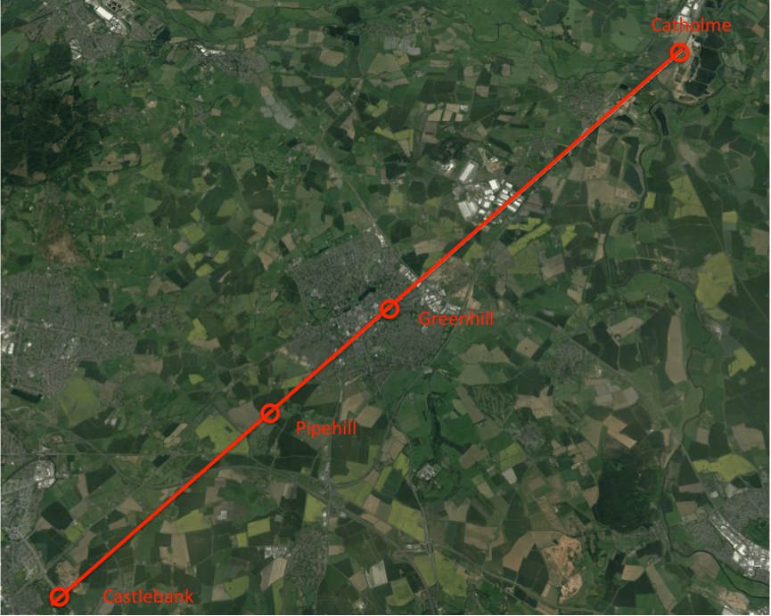
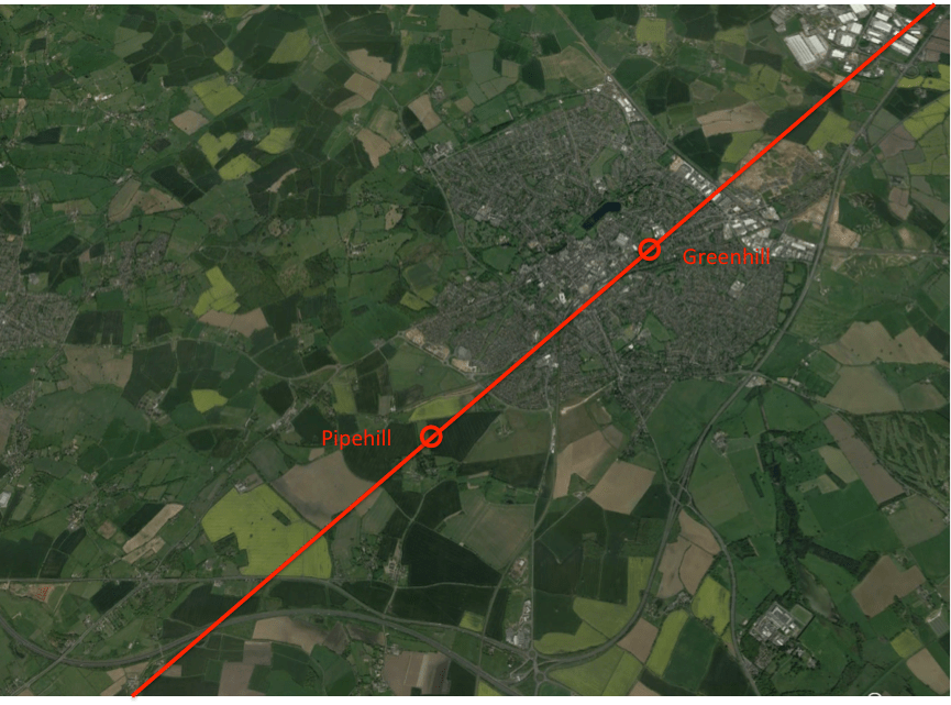
So there is a difference of around two degrees in the alignments from the various Catholme monuments. The next step is to find the direction of the midwinter sunset from Catholme around 2500BC. The latitude of that site is 52.74 degrees and the elevation can again be found from the profile produced by Google Earth. With the corrections specified by Wood (1978) this value comes out close to zero at -0.2 degrees. Wood (1978) gives a declination of – 23.98 degrees for 2500BC for the midwinter sunset. Putting these values into the above equation gives a value of 228.1 degrees for the midwinter sunset as seen from Catholme. This figure changes slightly to 228.0 degrees using the declination for 3000BC. Using the current value of declination, gives a direction of 229.1 degrees. Also of course there would be an offset of up to -0.5 degrees depending upon how the observer defined the sunset, and the particular topography that ultimately obscured it, giving the most likely value as being around 227.6 degrees. On this basis, the Woodhenge to Castlebanks line seems the most likely alignment. This is shown in the figures below. Figures 2 and 3 are Google Earth screenshots ands show the complete alignment and an expanded view of the alignment over the Lichfield area. Figure 4 is the elevation profile for the whole alignment. It can be seen that this line passes over Lichfield as expected, but its exact course is of interest. It passes over Greenhill (where the church of St Michael stands) and over the high ground at Pipehill, the source of the springs which provided water to Lichfield for many centuries. In fact from Carholme the midwinter sunset in 2500BC would have taken place over a line of hills – Greenhill in the foreground, the Pipehill ridge behind it and Castlebanks on the horizon. The midwinter sunset alignment here is so good, I do not think it can be accidental. The lining up of three prominent hills on a midwinter sunset alignment was probably just too good to miss for a Bronze Age priest who wanted to add another solar alignment to his ceremonial complex!
Figure 2 The Catholme – Castlebank alignment
Figure 3 Expansion of the map of figure 2 over the Lichfield area
Figure 4 Elevation profile of the Catholme – Castlebank alignment
Speculations on meaning
Clearly Catholme included solar alignments from its earliest date – the east-west axis of the cursus, with the Sunburst monument on the same alignment, would give two spring / autumn equinox alignments. The Woodhenge monument thus seems to have been positioned to create a midwinter sunset alignment with Castlebanks. What the ultimate purpose of these alignments were is of course impossible to know – they may have been purely for calendar purposes, or may have had a deeper cultic aspect. But from the perspective of a current Lichfield resident, I would like to ask if the Lichfield area were in any way, other than an accidental one, part of this overall scheme?
Now Pryor (2003), based on a study of a wide range of pre-Roman sites, identified the following characteristics that indicate the ritual use of such sites.
Solar or lunar alignments.
Rivers, marsh or open water, which has been used for votive offerings of weapons and other utensils, sometimes with causeways in to or across the body of water.
The proximity of barrows or other burials.
A distinction between the “domain of the ancestors” identified by “hard” stone monuments, and the “domain of the living” identified by “soft” wooden henges or monuments.
The usage of the site by many groups or tribes, as a communal meeting point.
Now let us address each of these issues in turn for the Lichfield area.
Clearly the Lichfield area meets the first of these criteria – as part of the longer Catholme – Castlebank alignment and also with Greenhill and Pipehill being on that alignment and having an internal alignment of their own.
In terms of rivers and bodies of water, there are clearly springs on both Greenhill and Pipehill, and the centre of Lichfield was likely to be quite swampy at the confluence of the Leamonsley and Trunkfield brooks. Both neolithic and bronze age axeheads have been found in the area, although the precise locations are not known. Such artefacts have been known to be ritually deposited at other sites (Carver, 1981).
There are a number of prominent barrows in the area, and in particular Offlow to the south, and possibly Borrowcop to the south east.
There is no archaeological indication of stone monuments from the bronze or iron ages in the Lichfield area, but there is of course the historical association of Greenhill with the rituals of death – the large graveyard at St Michael’s church and the dedication to the Christian “psychopomp”, the collector of souls. But these indications come from 2000 years after the Woodhenge monument was last in use.
Similarly with regard usage of the site for communal gatherings, Bassett (1981) has shown that in the pre-Roman era, Lichfield was the centre of an extensive trackway system linking a range of communities in the area. But again this reflects a later age.
From this it can be seen that there are perhaps some indications that the Lichfield area fulfils some or all of Pryor’s criteria for a cultic site set out above, including the existence of the solar alignment, and may be of importance as a cultic site from early times. But of course, as with all such speculations, final proof is impossible.
Bassett S (1981) “Medieval Lichfield: a topographic review”, Transactions South Staffordshire Archaeological and Historical Society, XXII, pp 93-121
Carver M G H (1981) “The archaeology of early Lichfield: an inventory and some recent results” Transactions South Staffordshire Archaeological and Historical Society, XXII, pp 1-12
Chapman, H, Hewson, M & Watters, M (2010) “The Catholme Ceremonial Complex, Stafforshire, UK”, Proceedings of the Prehistoric Society, London. 76, 135-163, 10.1017/S0079497X00000487
Pryor F (2003) “Britain BC”, Harper Collins, London
Wood J E (1978) “Sun, moon and standing stones”, OUP


