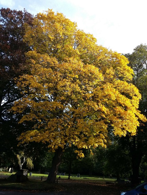
As I sit down to write this post, I find it hard to believe that there is anyone out there who will be interested in the ramblings that follow. But perhaps there are some from Pensnett who are as historically nerdy as I am……
In researching the history of Pensnett over the last few years, and in particular the history of the clergy of St Mark’s Church, I have come across mentions of a mission chapel in the Tansey Green area, but haven’t been able to find any further details or to locate where it was situated. There was another mission chapel in the parish of course, in Bromley, that is much better documented and had a long history. However, I have recently come across a 1949 history of the church by A Sergeant and L U Smith, written to mark its centenary (Dudley Archives LS9582/4B/21) . In that booklet there is the following little bit of information about the Tansey Green Mission Church.
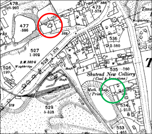
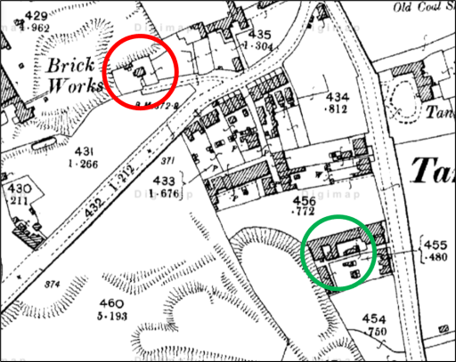
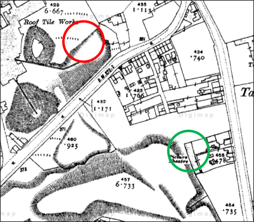
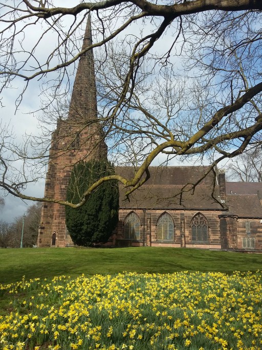
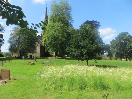
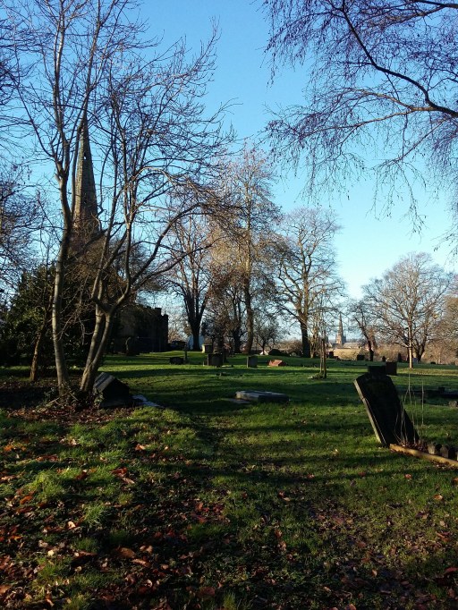
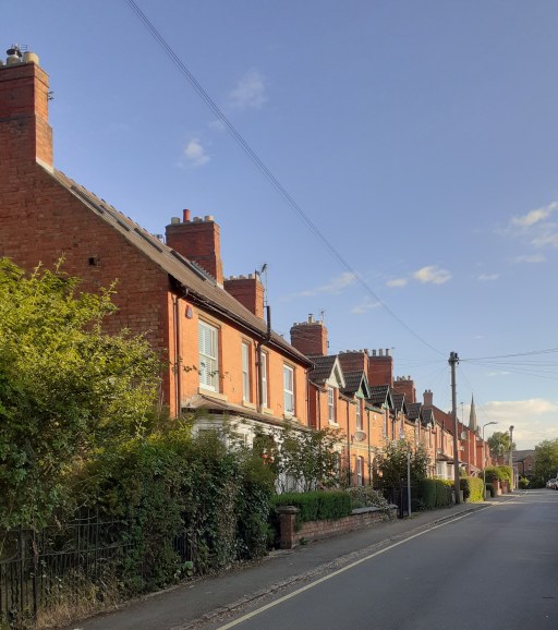
In 1849 the village of Pensnett was much smaller than now, consisting of a straggling line of houses and small shops along the south side of the main road, with a few short streets leading off it to the south, The parish, however, comprised a much larger area, and in it there were two other villages or hamlets. One of these was Tansey Green, where some time about the 1860’s a small mission room was founded. No records exist of this mission apart from some notes in the Services register of the number of communicants. In the year 1888 they numbered 17 in all. Some old residents of the parish still remember the tiny mission room standing on a site on Dreadnought Road which has. now been excavated as a marl-hole, The Mission room itself was demolished some years before the turn of the century.
This short extract gives enough information to determine the location of the church. The three maps below show the Ordnance Survey maps from 1880, 1900 and 1910. Dreadnaught Road (or Nailor’s Row as it was known in the mid 19th century) can be seen extending from the bottom left of the figures to the junction with Tansey Green at the top right. The building which I think must contain the chapel is circled in red – there seems to be no other option. It can be seen to be in existence in 1880 and 1900, but by 1910, its location was the centre of what was presumably a marl hole for the adjacent brick works. This isn’t quite consistent with the extract from the history above, as the building is still shown on the 1900 map and had not been demolished by then. This could be due to the unreliable oral memories on which the 1949 booklet extract was based. or simply that the map details were slightly out of date.
1880
1900
1910
Two further points can be made. Firstly the mission chapel was very close to the Shut End Primitive Methodist church (shown by a green circle), which had a a large local congregation – so perhaps there was some level of competition there between the established church and the non-conformists. But note that the congregation abandoned that chapel in 1896 due to mining subsidence and moved to a new location on Commonside and the building became a picture house – one of the earliest in the Black Country. Secondly the building that I have identified can also be seen, with a very similar shape and ground plan in the Fowler maps of 1822 and 1840, and is listed in the Directories to those maps as “house and garden“, owned by John Hodgetts Hodgetts-Foley and occupied by John Colbourne in 1822, and owned by James Foster and occupied by Thomas Bradley in 1840. It would thus appear that the Mission Chapel was simply a converted house or part of a house.
But beyond that there is very little to say, although I find it satisfying that I have at last been able to locate where the chapel was actually situated. I am still left wandering if this is of interest to anyone else at all!
First published on this site as a web age in June 2020, but republished as a blog post in august 2024 for consistency with other material.
Preamble
The Tribal Hidage, that most enigmatic of early texts, begins its perambulation of the polities in Southern England with a reference to “the first (or original) Mercian lands” (Davies and Vierck, 2010). It is the purpose of this short essay to unpack this phrase, and to see if it is possible to arrive at a coherent description of what was the original Mercia in the early / mid seventh century when, it will be seen, I take the Tribal Hidage to have been composed. We begin by briefly considering some aspects of the Tribal Hidage itself and then move on to a discussion of what can be deduced about early “kingdom” boundaries in the period of late antiquity – although the nature of the different polities discussed may well be very different from one another – through a consideration of detailed reconstructions from studies of regional history, and through consideration of ecclesiastical diocesan boundaries. We then discuss what might have been the nature of this early Mercian kingdom, through a consideration of the likely transport networks in its confines, and considers the historical events surrounding its establishment.
Throughout, we will work with what seems to be the developing consensus that it is difficult to separate Anglian, Saxon and British kingdoms on a strict ethnic basis, and most of the polities discussed will be of an ethnic mix, although it is clear that in the period of late antiquity following the withdrawal of the Roman armies, there was an increasing Germanic cultural influence throughout England, perhaps involving a relatively small migration from the Anglian and Saxon homelands. Such an approach seems to be consistent with recent archeological studies, which shows no major discontinuities in agricultural practices or evidence of major warfare in the early settlement period (Oosthuizen, 2017), and with recent genetic studies that show a homogeneous genetic background across most of England, although a genetic boundary between England Wales is apparent, and second level genetic differences can be observed in the South West, and in South Yorkshire (Lesley et al, 2015).
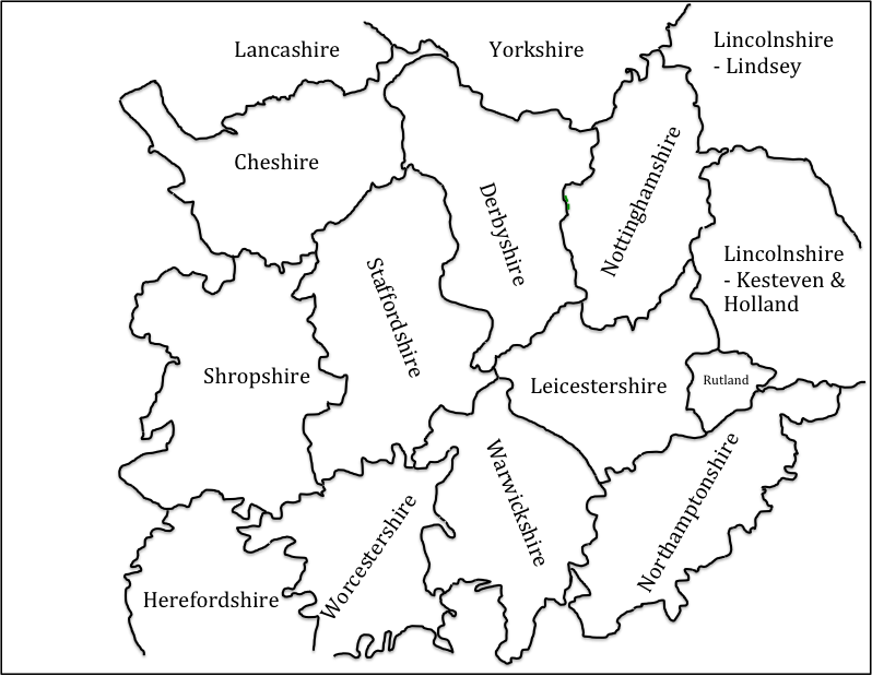
In what follows, an essentially geographical analysis will be presented in an attempt to locate the original Mercia, based on the drawing of boundaries of different types – kingdom boundaries, diocesan boundaries and county boundaries. Most of these are not contemporary with the period under consideration, and there is an implicit assumption that these boundaries reflect underlying and ancient boundaries from late antiquity. Whilst others have followed this route it is a somewhat dangerous course and open (quite rightly) to significant criticism. Also of course the concept of a boundary between peoples may or may not have been of relevance in the period under consideration and this needs to be borne in mind in what follows. These points having been made, we will in what follows use two scales of maps that both show, as the basis for relating to current geography, the pre-1974 county boundaries (see figure 1 for the larger scale of map that will be used). These counties were first defined in the 10thcentury, and remained relatively stable up to the 1974 re-organisation, although there have been continual minor modifications to boundaries over the centuries. In the area shown in figure 1, this has particularly affected the boundaries of Worcestershire, which became fragmented as a result of transfers of property from secular to ecclesiastical ownership and vice versa, with detached areas in the surrounding counties. These areas are not shown in figure 1 for clarity. There is one region however where the pre-1974 boundaries are not shown – the county boundary between the south west of Staffordshire and Shropshire – where there was an early (12thcentury) loss of land from Staffordshire to Shropshire due to the actions of Earl Roger to consolidate all his holdings into Shropshire (Thorn et al, 1986). As this region is particularly pertinent to the discussion that will follow, the Domesday boundaries for this region will be shown in all the maps that follow.
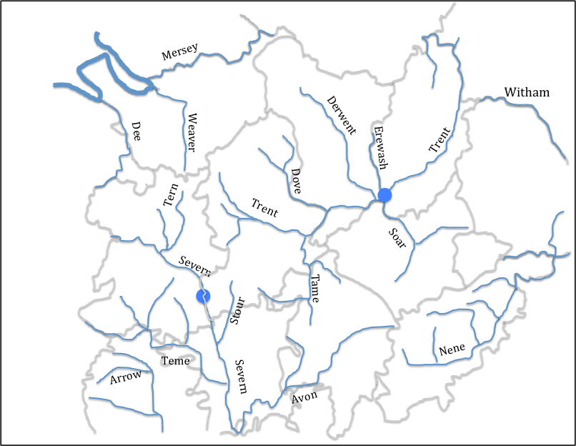
Figure 2 uses this map to illustrate the river systems in the English Midlands – and in particular the Trent, Severn, Wash and Cheshire basins. It is clear that the county boundaries in general follow river basin boundaries. In the area of interest here, this is particularly the case for the Staffordshire / Cheshire, Shropshire / Cheshire and Staffordshire/ Shropshire boundaries. The southern Severn / Trent basin boundary is also coincident with county boundaries, except in the case of Warwickshire which sits across the watershed between them.
Figure 1. The base map, showing pre-1974 county boundaries and names
Figure 2 Rivers and county boundaries
(Only major rivers and tributaries are shown. The blue filled circles indicate riverine locations of importance to the argument that follows below.)
The Tribal Hidage
The Tribal Hidage exists today in a number of different manuscripts, which are set out and compared by Dumville (1989). It essentially consists of two lists of kingdoms / polities of various sizes, with hidages attached to each entity. The date of the original document is disputed, with dates from the 620s to the 780s suggested (Corbett, 1900; Hart, 971; Higham 1995). I find the approach taken by Higham (1995), who proposes date in the 620s, the most persuasive, although this does not appear to be the universal view of historians. He suggests that it is in origin a tribute list of Edwin of Deira, dating from 624/5. The primary list is effectively a list of tributes payable to him from what Higham terms the Midlands “Overkingship”, whilst the secondary list was added perhaps a year later to indicate the tribute from the Southern “Overkingship”. The level of hidage seems to be standardized to 7000 for county sized entities, and to multiples of 300 for smaller entities particularly in the region know as Middle Anglia around the Wash and the East Midlands. For the Southern Overkingship entries in the secondary list, there is clearly a punitive element, particularly with the 100,000 hides allocated to Wessex.
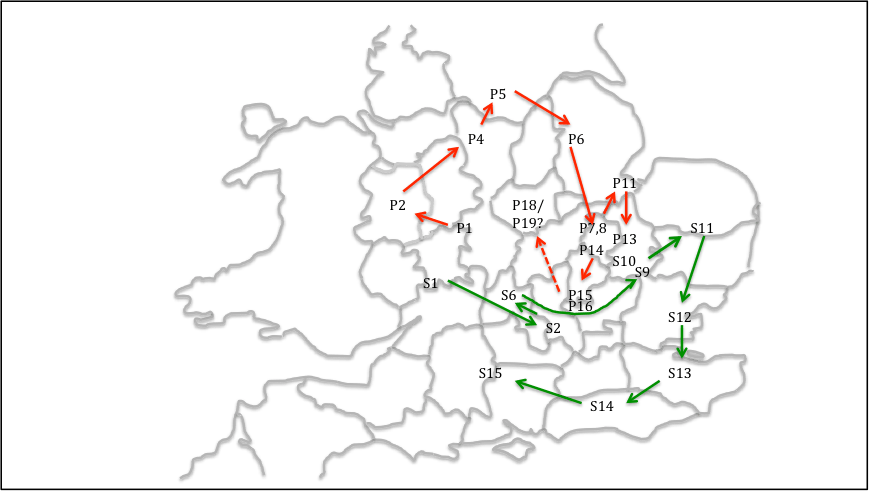
For the current purposes it is the order of the entries that is of most interest. The kingdoms on which most authors can agree are shown in figure 3 for both the primary (P) and secondary (S) lists. Original Mercia (P1 on the figure) is placed at the historic centre of the kingdom in south Staffordshire around Lichfield and Tamworth. A number of points arise from this figure.
There is a well-described clockwise progression in the primary list (and a subsidiary clockwise progression in the Fenland entities – based on the recent wok of Osthuizen (2017) and similarly in the secondary list. The latter list is indeed almost a closed loop. This is so marked, it seems to have been a specific intention on the part of the original compiler of the list.
The list includes Elmet, which was incorporated into the Deiran kingdom by Edwin (i.e. before 633) and Lindsey and Hatfield, which were never associated as a dual entity after the reign of Edwin. This argues for an early date for the Hidage (Higham, 1995).
The list does not include the Magonsaete in the south Shropshire / Herefordshire region, which was certainly in existence by 680 when it was ruled by Merewalh (note the British name), who is described by some as a son of Penda of Mercia. Again this argues for an early date (Pretty, 1989).
The area of Leicestershire and Northamptonshire, which the diocesan boundaries suggest is in Middle Anglia (see below) are not allocated any of the agreed kingdoms on the Tribal Hidage map. This suggests to me that the Noxgaga (P18) and Ohtgaga (P19) at the end of the primary list, both county sized entities, should be located in this area, rather than in the Middlesex / Surrey area suggested by some authors (Hart, 1977). This identification would make the primary list an almost closed loop.
This identification identifies the area around which the primary list loops to be in the Nottinghamshire area. This will be seen to be of relevance in what follows.
Figure 3. Tribal Hidage. “Firm” locations of regions in the primary and secondary lists
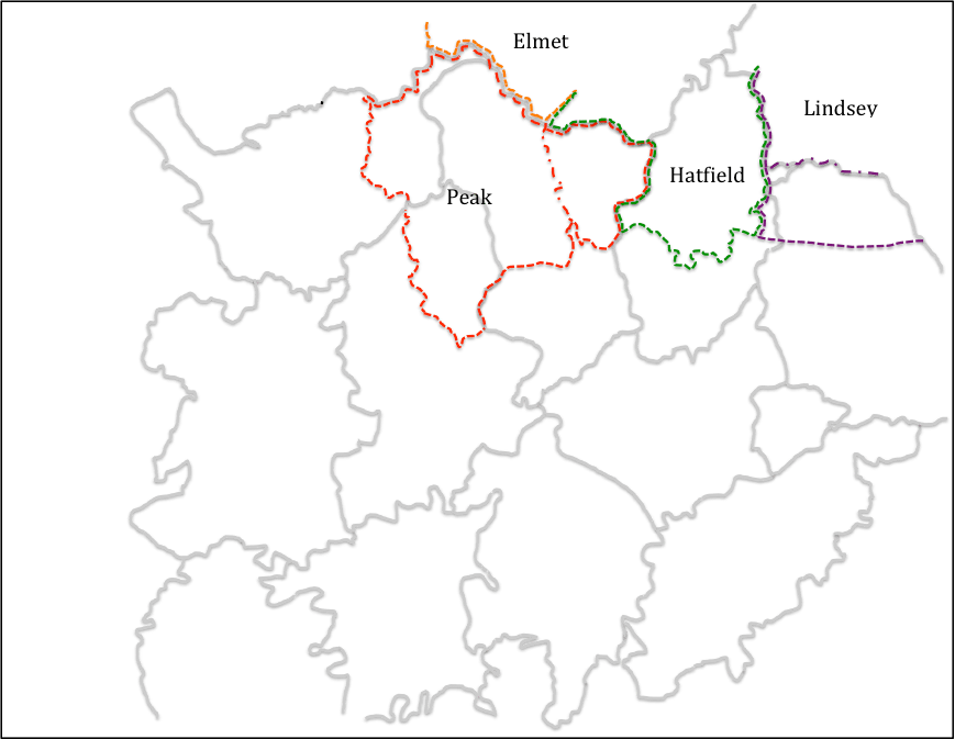
The work of local historians in various parts of England, who have carried out detailed work on boundaries of sub-Roman, early Anglo-Saxon polities that enables the boundaries of these polities to be drawn in more detail than the Tribal Hidage allows, even though these are to some extent speculative. Here we consider the work of Higham for the Pecsaetna in the Peak (Higham, 1993), Breeze for Elmet in South Yorkshire (Breeze, 2002), Parker for Hatfield in South Yorkshire / North Nottinghamshire (Parker, 1992) and Bassett for the kingdom of Lindsay (Bassett, 1989), All of these authors would, I am sure, have significant caveats for their work, but taken together they form a useful set of data. The boundaries they identify are again shown on figure 4. Higham suggests that the area of the Pecsaete consist of the Cheshire Domesday hundred of Hamestan, the Derbyshire hundred of the same name, plus the Staffordshire hundred of Totmonslow. The area of Hadfield identified by Parker includes not only the area of south Yorkshire that is usually so identified, but also north Nottinghamshire. The boundaries of the Pecsaete and Hatfield are, on this basis separated by a thin strip of Derbyshire (essentially Scarsdale Hundred), and it seems likely that the territory of one or the other of them extended to fill the gap between them. We choose here to extend the region of the Pecsaete into this area, as it will be seen below that a significant diocesan boundary separates Derbyshire from Nottinghamshire. Elsewhere the region of Elmet identified by Breeze can be seen to border on the Pecsaete, and the area of Lindsey is, following Bassett, taken to include not only the pre-1974 Parts of Lindsey to the north of the River Witham, but also a similar sized area to the south.
Figure 4 Kingdom boundaries in the north Midlands
(red dotted line shows the region of the Pecsaetna assumed in what follows – the red chain dotted line ins the boundary identified by Higham; the green dotted line shows the region of Hatfield; the brown dotted line shows the region of Elmet; the purple dotted line shows the region of Lindsey – with the chain dotted line showing the southern boundary of the Parts of Lindsey)
Now let us move to the consideration of the boundaries of church dioceses, particularly in the English Midlands. Some historians have expressed doubt about how the known medieval boundaries can be extrapolated back to the seventh century, the period under consideration here. This is particularly true of those areas which fell within the Danelaw where a number of dioceses ceased to operate. Nonetheless, they are used here for two reasons – firstly the 10th century Midland county boundaries follow these diocesan boundaries in many places and this suggests that the latter predated the former, and secondly, in many parts of the Midlands, there seems to be no record of any historical events that could have led to boundary changes. This is indeed the approach followed by Hart (1977) in his consideration of the Tribal Hidage, although he did not follow this approach to its logical conclusion.
The Mercian diocese came into existence in 655, and in its early days it covered a large region across the English Midlands. The situation changed with the reorganization of Theodore of Tarsus (Archbishop of Canterbury 669-690), who created dioceses based on “kingdoms” – a Lichfield diocese reduced in size for Mercia, Hereford Diocese for the Magonsaete (676), Lincoln diocese for the kingdom of Lindsey (678), Worcester diocese for the Hwicce (680) and Leicester diocese for the Middle Angles (681) (Podmore, 2008). These dioceses, as they existed in the late Anglo-Saxon era, are shown in figure 5, together with the relevant county boundaries (Ordnance Survey, ??).
From this figure it can be seen that the Mercian diocese covers much of west Warwickshire, Staffordshire, part of Shropshire, Derbyshire and the “land between the Mersey and the Ribble”. Clearly as such it encompasses the areas listed in the Tribal Hidage as Wocensætna and Pecsaetna, as well as whatever polities existed north of the Mersey, which must thus have been incorporated into Mercia sometime between the compilation of the Tribal Hidage (in 625 if Higham’s argument is accepted) and the re-organisation of dioceses in the 670s.
Equally significant are those areas that are not part of the Mercian diocese. Firstly Nottinghamshire has been, from at least 956 when the church was re-established following the Danish conquests, part of the York diocese (Stenton, 1968). At this time the area based on the minster church of Southwell, which was granted to Oskytel, Archbishop of York by King Eadwig. It seems likely to methat this was simply are-establishment of the pre-conquest status quo. There is a local tradition that the area was first evangelised in the early seventh century by Paulinus operating from York. Thus, in ecclesiastical terms, Nottinghamshire looks to the north and the Humber, rather than to the Midlands and the diocese of Lichfield. Secondly, the counties of Leicester and Northamptonshire are in the Leicester (i.e. Middle Anglian) diocese. Hart, in his definition of the geography of Mercia, arbitrary labels this area as “outer Mercia” (Hart, 1977), an entity which has no historical context at all. The fact that it is regarded as being in Middle Anglia is consistent with the argument set out above that the Noxgaga and Ohtgaga should be located in this area.
Figure 5 Diocesan and county boundaries.
Locating the original Mercia
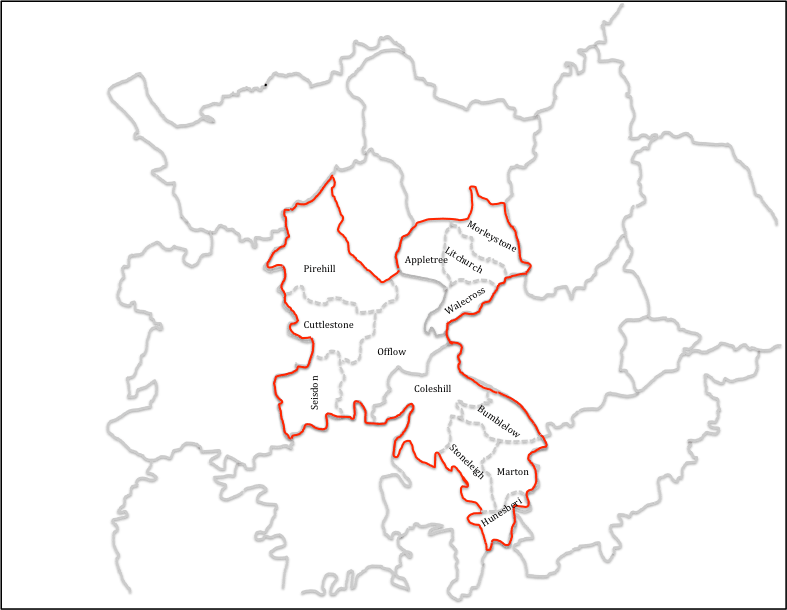
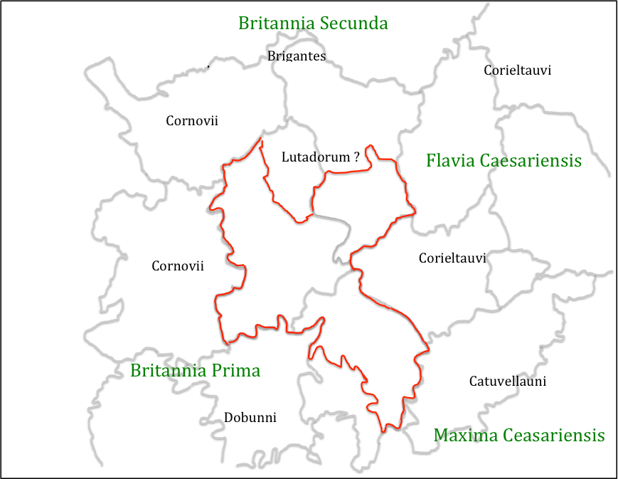
An attempt can now be made at locating the original lands of Mercia, about which the Tribal Hidage seems to revolve – see figure 6. The diocesan boundaries and boundaries of other kingdoms would suggest that this region included west Warwickshire, south Staffordshire and south and east Derbyshire. The main unknowns are the location of the northern and western boundaries. With regard to the northern boundary, this has been chosen to exclude the long neck of land between the regions of the Pecsaete and Hatfield, as identified by Higham and Parker, as this seems the more logical geographical boundary. The boundary shown in figure 6 thus forms the southern boundary of the Domesday Scarsdale Hundred. With regard to the western boundary, the logical place for this would be on the watershed between the Trent and Severn basins. This is followed by the western border of Staffordshire, except for Seisdon hundred in the south, where part of the catchment of the Stour, a tributary of the Severn, is included within Staffordshire and the Domesday county boundary was the River Severn itself. The boundary of the original Mercia is drawn to follow the Staffordshire boundary even in this region for reasons that will become apparent below. The original Mercia thus consists of the Staffordshire Domesday hundreds of Seisdon, Cuttlestone, Pirehill and Offlow (the latter containing Lichfield), the Derbyshire hundreds of Walecross, Appletree, Litchurch and Morleystone and the Warickshire hundreds of Coleshill, Bumblelow, Stoneleigh, Marton and Hunesberi. Many authors have pointed out that this region lacks natural boundaries or defensive positions of any sort, and this will be considered below. But at this point the reason for the name of the kingdom – the borderlands – becomes obvious if this area is considered in terms of the Roman Civitas, the broad areas of which are also shown on figure 7 (it is not being possible to draw these with any precision) together with an indication of the Provincial areas following the reorganization of Diocletian (Jones and Mattingley. 1993). There is coming to be agreement that throughout the fifth and sixth centuries there was some continuity in Civitas level government, at least in the west of England, either through Governors or through kings (Dark, 2000). On the presumption that something similar to these Civitas continued to exist in some form into the late 6thcentury, it can be seen that the original Mercia sat across the borders of a number of them – the Dobunni in Worcestershire and Gloucestershire, who seem to have morphed into the Hwicce; the Cornovii in Shropshire / Chester, who became the Wocensætna, the Corieltauvi in Warwickshire / Leicestershire / Lincolnshire; the Catuvellauni in Northamptonshire / Bedforshire / Buckinghamshire, and, if it actually existed, Lutadorum in the Peak District, who can perhaps be identified with the territory of the Pecsaete. It would seem that Mercia took land from all of these and straddled the borders of each, and in doing so straddled the borders of at least three of the four late Roman provinces.
Figure 6. The original Mercia mapped.
Figure 7. The original Mercia and Civitas and Provincial regions
(Civitas names in black, Provincial names in green)
The point has often been made that the original Mercia, whatever its precise location, lacked natural boundaries. However this is probably a misconception. Figure 8 shows the original Mercia as identified above, together with the established Roman road network, which was usable well into Medieval times, and also some conjectural, but likely roman roads. This changes the picture of Mercia significantly. It can be seen that the centre of the kingdom at Lichfield / Wall sits on a major junction of roads, from where small bands suitably mounted and armed could reach all parts of the kingdom very quickly and could establish control over a wide area. Also at the borders there were at least the locations of Roman towns which could have acted as regional centres – Water Eaton to the west, Greensforge to the south west, Metchley to the south, High Cross to the south east and Derby to the north. Perhaps most importantly this network would also allow control of trade across the whole region – and thus control of major trading routes across England – Watling Street between High Cross and Water Eaton; Ryknield Streets between Derby and Metchley, as well as the northern saltways from Droitwich. To this road network, can be added strategic riverine locations at Sawley – the junction of the Trent, Erewash and Soar, and on the Severn at Quatford, which could thus control major river traffic flows. The latter is the major reason for suggesting that Seisdon hundred in Staffordshire was part of the orginal Mercia, as it gave control over the saltway at Greensforge and the roads to the borders and mid Wales, as well as access to the Severn at Quatford. This interpretation thus sees the original Mercia as very much a commercial enterprise as well as one in kingdom building.
Figure 8 – Communications networks
(blue indicates probably and possible Roman Roads; red indicates locations within the Original Mercia; green indicates major locations outside this area. Blue circles indicates the riverine crossings at Quatford (in the west) and Sawley (in the east)
Finally the question arises as to whether or not there is a historical context into which the above scenario could fit. Here there is little alternative but to use the evidence of the various chronicles and early histories, and which are open to serious challenges as to their veracity and utility. With that proviso, they are used and viewed as broadly reliable in what follows.
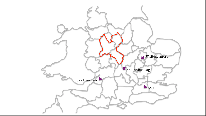
The third quartile of the sixth century was a time of expansion by the kingdom of Wessex, as illustrated in figure 9. In 568 a Wessex force led by Ceawlin and Cutha, defeated Aethelberht of Kent, and pushed him back towards his homeland. In 571, in a northern advance, Cuthwulf defeated British force at Bedcanford (usually taken as Bedford) taking control of a number of towns in that region. This was followed in 577 by the battle of Deorham, where three British kings were again defeated by Cuthwine and Ceawlin and three major towns taken – Bath, Glouccester and the capital of the Province of Britannia Prima, Circencester. Then for 584, for Anglo-Saxon chronicle reads
Ceawlin and Cutha fought with Britains at the place called Fethanleag and Cutha was killed, and Ceawlin took many townships and countless spoil and returned in anger to his own.
Here Cutha is a king in Wessex, and Fethanleag has been identified as Stoke Lyne near Bicester in north Oxfordshire – a few miles south of the southern border of Mercia shown in figure 6. Davies (1977) relates this to an entry for the next year in the Henry of Huntingdon’s Historia Anglorum which states
585 Beginning of the kingdom of Mercia, with Crida
If one can make that equation, this suggest that Cutha met his match in an essentially British force that stopped the northern expansion of Wessex, and that this force was led by Crida who then went on to establish the kingdom of Mercia as outlined above, and a dynasty in the form of Crida, Pybba and Penda. Note the partially British name of the latter, which strongly suggests a kingdom of mixed ethnicity. The dynasty was known as the Iclingas after the (perhaps mythical) ancestor Icel, and the Anglo Saxon Chronicle gives the names of his descendants before Crida as Cynewald and Cnebba. As noted by Myers there are a number of place names that reflect the name Icel across Suffolk, Cambridgeshire and Hertfordshire, and there is a concentration of names based on Pybba (Pedmore) and Penda (Pendford, Pinvin) in the Worcestershire / south Staffordshire area, suggesting the popularity of these names around there.
The nature of the original Mercia is however still elusive. It may be that Crida’s family of the 580s, simply took the region centred on Wall and held it by force of arms against the neighbouring polities. Dark would suggest that these polities were the remains of the sub-Roman Civitas system, which to the east were clearly (from the evidence of the small polities of the Tribal Hidage in the East Midlands) in the process of dissolution due to internal pressures, and perhaps also the pressure of migrating Saxons from the area around the Wash and the Humber; whilst in the west bureaucratic Civitas governments of the Dobunni and Cornovvii may well have been in their final sharp decline. This suggest the possibility (and it can be rated no higher than that) that the family and their followers were effectively foederatiemployed by these bureaucratic governments to resist the growing pressure of Wessex from the south and the chaos enveloping their eastern borders. If so, then their eventual subjugation by an expanding Mercia might suggest that this was ultimately not a good move.
In the early seventh century, there does seem to have been a break in the succession, and Bede tells us of another Mercian king – Cearl – who took the refugee and later Deiran King, Edwin, under his protection in around 605. Higham argues that he was the Midlands Overking at the time, able to resists the demands of Aethelfrith in Northumbria for the return of Edwin (Higham, 1995). The fact that Edwin was able to reach Cearl easily, and after Cearl’s death find refuge with Raedwald in East Anglia, strongly suggests that Ceorl’s activity was in the north midlands – perhaps in the south of Nottinghamshire which has been identified as an anomaly in diocesan terms. In this scenario, Cearl would have been of northern Anglian stock, but Bede would have referred to him as king of Mercia, because the region in which his power was centred was Mercian in Bede’s day. Taking this further one can perhaps see the primary list of the Tribal Hidage as a tribute list of Cearl, in which the punative 30,000 hides of the original Mercia reflected a recent takeover from the Icinglas dynasty that was not to prove permanent. It can also be speculated that Ceorl’s territory was that of the North Mercians mentioned by Bede, with the original Mercia being South Mercia. In taking over Ceorl’s territory, Penda would thus become the first king to “separate the Mercians from the Northumbrians” as also noted by Bede. But here we are in the realms of speculation, and his must be only one of many possibilities of the situation on the ground in the early seventh century.
Figure 9 Anglo Saxon Chronicle battles of the mid / late sixth century
Dumville D (1989) “The Tribal Hidage: an introduction to its texts and their history”, in: Bassett, S (ed.), The origins of Anglo-Saxon kingdoms, Studies in the Early History of Britain, Leicester: Leicester University Press, 225–230, 286–287.
Hart C (1971) “The Tribal Hidage”, Transactions of the Royal Historical Society, Fifth Series, 21 (1971), 133-157
Hart C (1977) “The kingdom of Mercia” in Mercian Studies, edited by Ann Dornier, Leicester University Press, 43-62
Higham N (1993) “The origins of Cheshire”, Manchester University Press
Higham N (1995) “An English Empire – Bede and the early Anglo Saxon kings”, Manchester University Press.
Jones B, Mattingly D (1993) “An Atlas of Roman Britain”, Blackwell
Ordnace Survey (???) “Monastic Britain”, South sheet, 2nd edition
Oosthuizen S (2017) “The Anglo-Saxon Fenland”, Windgather Press
Podmore C (2008) “Dioceses and Episcopal Sees in England – A Background Report for the Dioceses Commission”, DC/R3
Pretty K (1989) “Defining the Magonsate” in: Bassett, Steven (ed.), The origins of Anglo-Saxon kingdoms, Studies in the Early History of Britain, Leicester University Press, 171-183
Stenton F (1968) “Anglo Saxon England”, The Oxford History of England, 2nd edition, Oxford University Press.
Thorn F, Thorn C (editors), Parker C (translator) (1986) “Domesday Book – Shrops
First published on this site as a web page in April 2020, but format changed to post in August 2024 for consistency with other material
Introduction
It has been noted by a number of authors in the past that in the vicinity of Lichfield, the ecclesiastical centre of the Mercian kingdom, there are a number of place names with pagan religious associations, and puzzlement has been expressed that such names were allowed to survive by the ecclesiastical authorities (Horowitz, 2005, p32). In this article, we consider these names further and identify a small number of other sites in the locality that may also have pagan religious connections. In so doing we are led to the tentative conclusion that Lichfield may have been a centre for pagan religious activity in the pre-Christian era, and the echoes of this activity, remain in place names and church dedications in the area. This suggestion goes some way to explain the rather odd comment recorded in an early life of St Wilfred, that he gave Lichfield to Chad for the site of his cathedral in 669, as it was suitable place for an episcopal see – in that it was already an ancient cultic site (Colrave, 1927). We begin in the next section by briefly considering the work of North (North, 1997), who investigated in particular the deity known as “Ing-Freyr”, for reasons that will become obvious in what follows. We then move on to a consideration of place names and church dedications in the Lichfield area. An attempt is then made to synthesise the findings, and to draw out their implications. Finally, further possible indications of cultic activity in the Lichfield area in the Roman / British era and before are briefly mentioned.
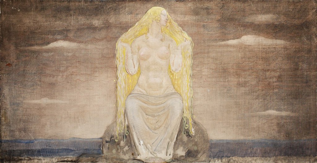
Ing-Freyr
Ing-Freyr by Hugo Hamilton
Through a detailed examination of the work of the Roman Historian Tacitus who described the worship of the Angles in southern Denmark in the first century AD; the much more recent Scandinavian myths recorded in Iceland around 12thand 13thcenturies; king lists from the early English kingdoms and a range of Old English literature from the Anglo-Saxon period, North arrives at the conclusion that the worship of the deity “Ing-Freyr” can be detected in England before the conversion. He argues that the cult of Ing-Freyr directly descends from that of Nerthus, who seems to have had the attributes of a sky god, in the early Roman era by the Angles in southern Denmark. Tacitus describes this as centring on a oxen hauled wagon procession of the god, either represented by an idol of by a nominee, around the tribal region, with the celebration of a marriage to the earth goddess Terra Mater, symbolised by copulation with local women or with a nominated female. This rite had obvious fertility aspects, and also seems to have involved the “death” of the God (either through the symbolic interring of the idol, or perhaps through human sacrifice) after the wagon tour, and his resurrection in the following spring. The suffix “Ing” can be found in a number of early Anglian king lists, indicating the persistence of the cult into the Anglo-Saxon era and can be traced through various Old English texts. Freyr simply means “Lord” and in the Nordic myths was the son of Njoror (the equivalent of Nerthus) and the brother of Freyja, who were all members of the Vanir, the old gods who were the losers of a cult war with the Aesir headed by Odin. The name Freyja simply means “Lady” and is widely regarded as a fertility deity, and also as a “psychopomp” who attended to the souls of the dead. In some myths she is identified with Frigg, the wife of Odin The concept of a dying and rising God has of course resonances with Christianity, and North, somewhat mischievously, writes
…the Angles, in particular, offered no resistance to Christianity and indeed failed to perceive the difference between the new religion and their own…. (North, 1997, 305)
However, whilst the cult of Ing-Freyr could clearly have played a part in the conversion of the Angles, ultimately for the Church there was the possibility of much confusion with the orthodox faith that was potentially very damaging. There is some evidence that the Church thus came to equate Ing-Freyr with the devil (North, 1997, 56-57, 325), and the cult was firmly suppressed. This was partly achieved through his replacement in king lists and names by Odin, an ambiguous figure, both a deity and a real or semi-mythical Swedish ancestor, but who was clearly not regarded as a threat to the church in the same way as Ing-Freyr[vi]. One of the attributes of Odin himself was that of the psychopomp.
Whilst the arguments of North are based on widely diverse sources, both in terms of content and date of composition, they are nonetheless cogently argued and present a convincing case that, in the pre-conversion era, the cult of Ing-Freyr could be found amongst the Anglian peoples of Britain. The implications of this for the Lichfield area will become clear in the following sections.
Place names and Church Dedications
The name of Lichfield itself remains something of a mystery (Horowitz, 2005, p16). The early (medieval) understanding, based on the writings of Matthew Parris, a monk of St Albans, was that it carried the meaning “Field of the dead” and was the site of the martyrdom of Christians during the persecution of Diocletian from 284 to 305, with “Lich” being derived from the Old English word for body or corpse. Early spellings of the name however suggest that such an interpretation is at best debatable, and the accepted wisdom is that the name derives, through a complex system of intermediate forms, from the Celtic word that evolved into Letocetum (Wall) in the Roman era, and means the open place by the grey wood (Horowitz, 2005, p17). What the grey wood might be has however not been explained, although of itself it to some degree numinous, with perhaps some symbolic meaning and content relating to the dead or the supernatural.
If the name of Lichfield cannot be fully explained, other names in the vicinity are less ambiguous. There are two “Woden / Odin” names to the west – at Wednesfield (Horowitz, 2005, p566) and at Wednesbury (Horowitz, 2005, p565), with names that mean the open land dedicated to Woden, and Woden’s fortification respectively. A little way to the east, on Watling Street, we find Weeford – the ford of the idol or shrine (Horowitz, 2005, p29). Less certainly, in between Weeford and Lichfield, we find Freeford (Horowitz, 2005, p32) (Horowitz, 2005, 30), . Whilst this might simply mean free, or unrestricted, ford, a possible variant is Freyja’s ford, which, in view of the theories of North set out above, may well be of some significance. Weeford and Freeford were two of the five original (and quite possible pre-Domesday) prebends of Lichfield Cathedral, the others being Longdon and Handsacre to the west, and Stotfold or Statfold to the east.
Freja (1905) by John Bauer
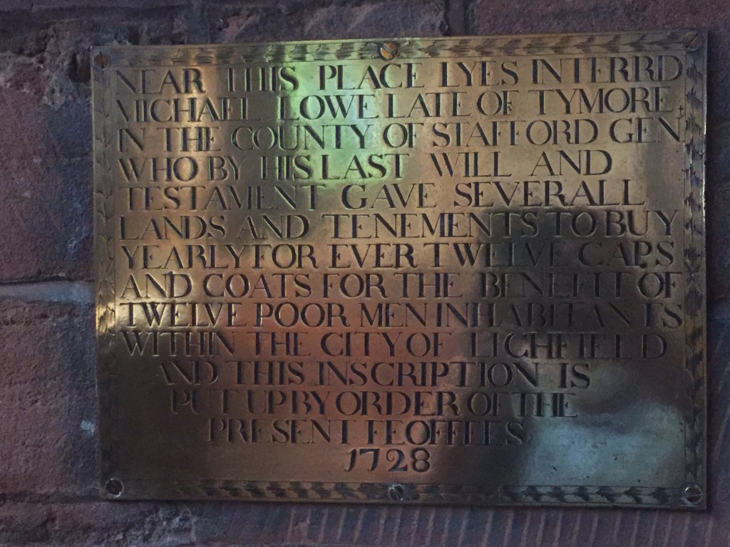
However there are a small number of other sites that may have connections with pagan worship in the area. The first is the last of the five prebends just mentioned. Stotfold (Horowitz, 2005, p510) carried the meaning of (horse or oxen) stud fold. The horse itself had ritual significance in the Anglo-Saxon period, but it is the possible association with oxen that is clearly of significance to the current discussion. Also, just to the south of Freeford we find Ingle Hill (Horowitz, 2005, p336). Horowicz is not certain on the derivation of this, offering a rather tenuous connection with the Inge family who were apparently in the Lichfield area in the 18thcentury. The root however is exactly the same as Ingham in Lincolnshire, Norfolk and Suffolk (all regions of Anglian migration), which does seem to be connected to the deity Ing (Mill, 1991). We thus have the names Weeford, Freeford, Stotfold, and Ingle Hill all in close proximity, and whilst the derivations of all but the first are arguable, their geographical coincidence strongly suggests a connection with pagan ritual. All these places are also part of a large land unit that was eventually to become the Domesday manor of Lichfield, and then the large parish of St Michael’s Church on Greenville (James, 1998). Basset (1992) argues that this was actually a pre-Augustinian British Diocese, and whilst this may be possible, it may be simply a land unit that arose for different reasons. Finally, there is the possibility that one of the members of the Domesday Lichfield land unit, Tymmore (whose meaning has not been addressed by place name scholars) could refer to the god Tyr, the moor in question perhaps being Whittington Heath to the east of Lichfield (Morris, 1976). Place names thus suggest an unusual level of pagan activity or memory in the Lichfield area in the period from which the settlement names derive
Memorial plaque to Michael Lowe of Tymore in St Michael’s church, Lichfield
Within Lichfield, there are three parish churches and the cathedral. Bede tells us that the latter was originally dedicated to St Peter and St Mary (Kettle andJohnson, 1970), but at least by Domesday, the dedication was to St Chad and St Mary. Thus the dedication was to the “Lady” of the Christians and to the chief apostle, and latterly to the major local holy man. The three churches are dedicated to St Mary, St Chad and St Michael. The first was a medieval creation for the planned town of Bishop Roger de Clinton in the 12thcentury. Of the latter two, the land unit evidence discussed by Basset suggests that St Michael’s is the older, and that St Chad’s parish was originally included within it (as were the parishes of St Mary’s and the Cathedral Close). In St Michael we have both the angel who threw the devil to earth from heaven, as well as the Christian psychopomp. The huge size of St Michael’s graveyard has frequently been pointed out, and whilst this size may be purely functional, it might nonetheless indicate early association of the area with the concerns of the dead (James, 1998).
Of the three prebends of Lichfield discussed above, Freeford and Stotfold have no chapels of their own and seem to have always looked to St Michael’s as the mother church. The church at Weeford is again dedicated to Mary. Away from Lichfield, there does not seem to have been an ancient church at Wednesfield, but at Wednesbury the hilltop church is dedicated to St Batholomew. Interestingly there are two other Bartholomew dedications in the vicinity – at Hints on Watling Street near Weeford to the east of Lichfield, and at Farewell to the west. Bartholomew is one of the lesser known of the disciples in biblical terms, but one of his traditions relates that he was martyred by being skinned alive. He is regarded as the patron saint of tanners, which is perhaps a tenuous connections with the ox wagon procession that is identified herein. He is also identified with Heracles, perhaps through a similarity of iconography, with Heracles holding the skin of the Nemean lion in a similar manner to Bartholomew holding his flayed skin (Crane and Lazzarotti, 2014), and through Heracles / Hercules to Balder, the dying / rising God of Norse myth, which is shown by North to be identified with Ing (North, 1997, 143).
Finally the church at Shenstone to the south of Lichfield, is dedicated to St John the Baptist, whose feast day is on midsummer eve. There is a long and proven European tradition of midsummer bonfires on hilltop sites (possibly where bones were burnt) that goes back to Roman times (Hutton, 1996), and the dedication to St John suggests that these occurred at Shenstone, and might go some way towards explaining the rather curious name (Horowitz, 2005, 488), which means “Shining Stone”. There are no obvious stones to which this could apply in the vicinity, but the name could conceivably apply to an idol illuminated by a bonfire.
Synthesis
At this point it would be easy to fall into wild speculation concerning the implications of all the above, and perhaps particularly on the route that might have been taken by an ox drawn idol bearing wagon. We resist that here and simply emphasise two major points. The first is that place name evidence strongly suggest that the region around Lichfield was the centre of a cult of Ing-Freyr, and perhaps Freyja, with some indications that the ancient wagon procession cult was at least remembered if not wholly practiced – the names of Freeford (Freyja’s ford), Ingle Hill (Ing- Hill), Weeford (Idol ford), Stotfold (Oxen or horse fold) and perhaps Shenstone (Shining Stone). This implies the early existence of both a fertility cult, with an annually dying and rising deity, and with a cult of the dead. The second point is that this cult seems to have been supressed in exactly the way that Pope Gregory recommended to St Augustine – to use and hallow the pagan shrines for Christian worship. The three pagan sites of Weeford, Freeford (which includes Ingle Hill) and Stotfold were eventually to become prebends of Lichfield Cathedral; the worship of the Lord Ing-Freyr and the Lady Freyja was replaced by the worship of Christ as mediated through the chief apostle Peter and the local holy man Chad, and “Our Lady”, the Virgin Mary. The pagan psychopomp Freyja was replaced by the Christian version, the Archangel Michael, who from the summit of Greenhill would proclaim the Christian victory over the Lord and Lady of the Vanir. Away from Lichfield itself, the fires at Shenstone, that perhaps used to illumine the travelling idol, became dedicated to St John, and whatever occurred at Wednesfield, Wednesbury, Hints and Farewell was neutered using the ambiguous name of Woden / Odin, and the rather dramatically martyred St Bartholomew. But the suppression was not wholly complete. Some of the names in the vicinity were too deeply ingrained in the local consciousness to be eliminated completely, and the association of Lichfield with both the cult of the dead and with fertility was to endure, through the long history of the graveyard at St Michaels, and through the Greenhill Bower respectively. Interestingly, and perhaps amusingly, as late as the 14thcentury the incumbents of the (once pagan) prebends of Freeford, Weeford and Stotfold still appointed chaplains to the three (Christian) city churches of St Mary, St Chad and St Michael (Greenslade, 1990).
In the above no attempt has been made to give chronological depth to the above suggestions and give suggested dates other than the firm one of 669 for the beginning of Chad’s episcopate. Place names and church dedications simply do not allow a precise chronology of the interaction between pagan and Christian worship to be developed. So we have simply set out the evidence that suggests that, in the pre-conversion period, there was a significant and identifiable pagan activity in the Lichfield area, that had both fertility and mortuary aspects, and was ultimately supressed, albeit far from effectively, by the Christian church.
Earlier possibilities
We have concentrated above on the interface between Anglian pagan worship and Christian worship, potentially in the sixth and seventh centuries. However there’re a number of indications that the Lichfield area might have cultic past that goes back further than that. James (1999), based on the work of Morris (1989), argues that the church dedication to St Michael on Greenhill could have displaced an earlier cult of Mercury, who has many of the same attributes, including that of psychopomp. In turn this could be related to the cult of the Celtic / British deity Lugos, who again had the same attributes. Also, as noted above, Bassett (1992) argued that St Michael’s could have been the centre of a late Roman ecclesiastical diocese. How the various competing cultic sites of the Roman / British and Anglo-Saxon periods might have related to each other is not at all clear.
Going back still further, it is quite possible that Lichfield itself is part of a major solar alignment, with the Cathedral, St Chad’s Well, and the Bronze age site at Catholme all being on a midwinter sunset / midsummer sunrise alignment. The cultic implications of this are the subject of speculation is a related blog post.
References
Basset S (1992) “Church and diocese in the West Midlands; the transition from British to Anglo-Saxon control”, in Pastoral Care before the Parish, ed. J. Blair and R. Sharpe (Leicester University Press), pp13–40.
Colrave B (ed) (1927) “The Life of Bishop Wilfred by Eddius Stephanus”
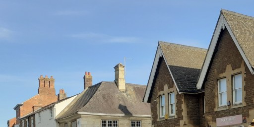
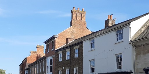
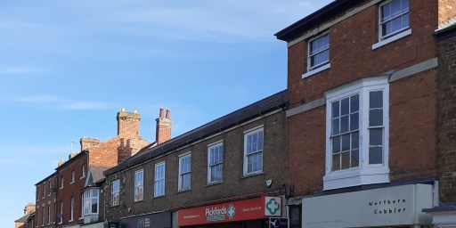
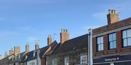
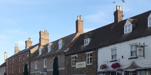
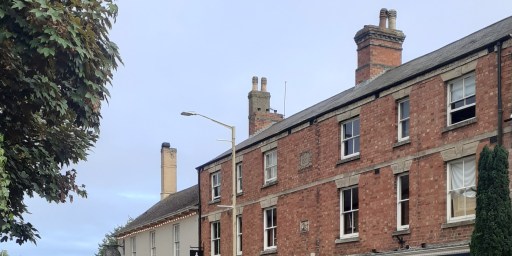
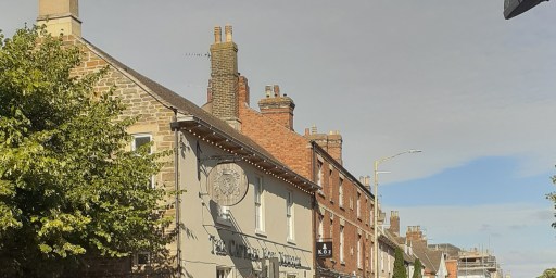
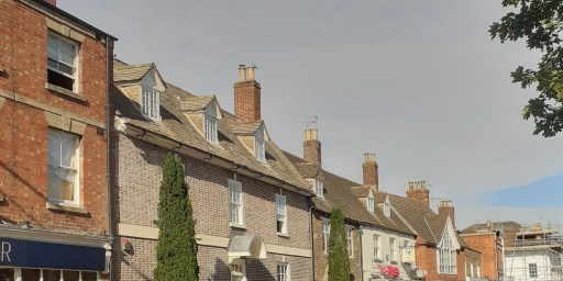
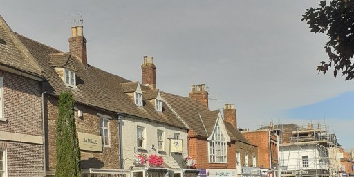
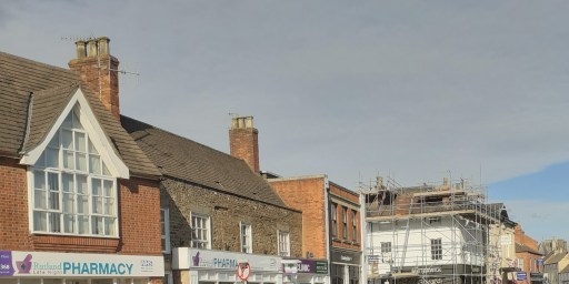
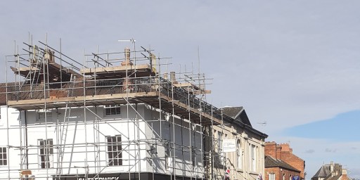
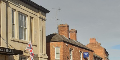
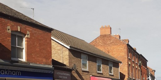
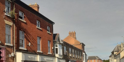
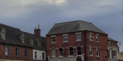
This post concerns roofs 1 – specifically those on the High Street of Oakham in Rutland. I find the upper floors of urban streets quite fascinating in their form and variety. When walking through towns however, one rarely looks upwards – indeed most of the time you would risk colliding with other pedestrians or walking into the road if you did. It is the shop fronts and their contents on the lower floors that command attention of course. But above them, the buildings themselves are sometimes stylish, sometimes idiosyncratic, sometimes merely odd – and usually worth a look. In what follows I show two galleries of photographs, both looking at the upper floors of buildings on the north side of Oakham High Street, taken from the pavement on the south side. The first gallery is a series of photographs from east to west (the junction with Burley Street and the Market area to the Wetherspoons pub), and the second from west to east. I am not really in a position to comment on the buildings in architectural terms, so the photos are simply presented for the reader’s interest and enjoyment.
1 I am fairly sure that when I was at school I was told that this was spelt “rooves”, but Google informs me that this is an archaic word, no longer used in practice. I fear I am thus labelled as archaic, which is probably true.
From east to west
From west to east
All the photos were taken by me, but I am happy for them to be used by others, with a proper acknowledgement.
A picture blog featuring the photographs of Maureen Brand – evocative pictures of the churchyard of St Michael in Lichfield through the changing seasons.
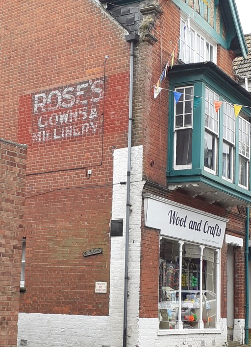
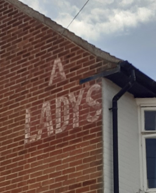
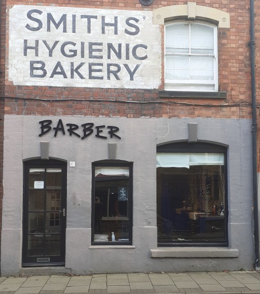
A new interest of mine – the old, faded painted signs on buildings whose function has changed. There are just a few photos for now, and I will add more as I come across them. For those interested there is a much greater selection at this Historic England site.
Oakham, Catmose StreetOakham, Mill StreetOakham High StreetCromerWest RuntonScarborough, Rothbury Street
And from November 2024, the sign in Mill St, Oakham has been repainted or perhaps resurrected or re-embodied?
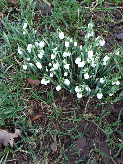
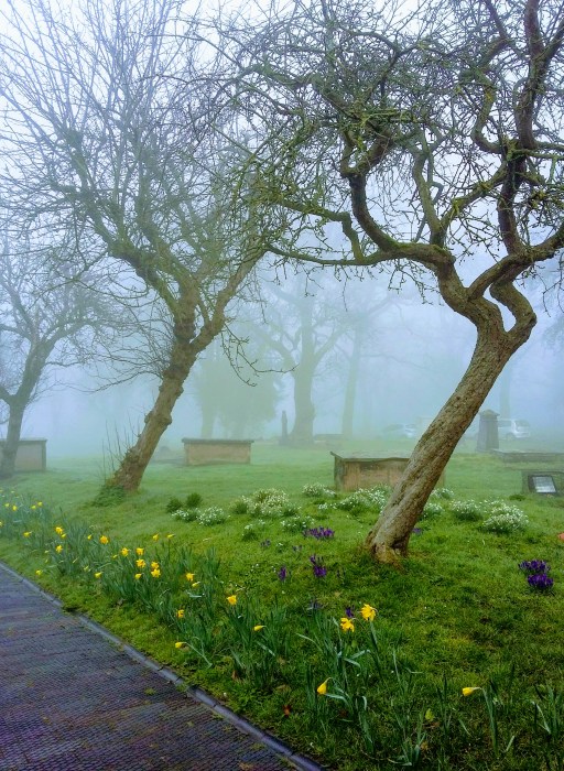
This is a picture blog, that simply gives pictures of a walk around Oakham. This is not a walk that takes in the traditional historical highlights, although some of those are included, but is rather one in which I show the things that have caught my eye, mainly on my wonderings about the town with the dog. So it is a little idiosyncratic, but I hope will be of interest to some. Except where otherwise indicated, the pictures were all taken by me, and I am happy for them to be used by others, properly credited of course.
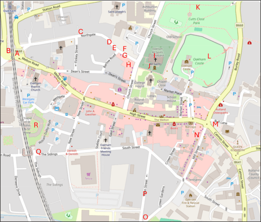
The map
The map below shows the approximate locations from which the photographs (A to R) were taken, superimposed on an up to date map from Open Street Map.
The pictures
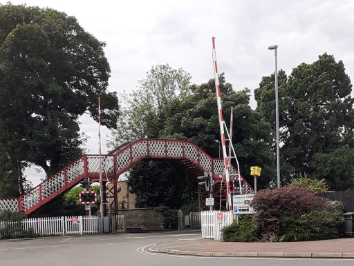
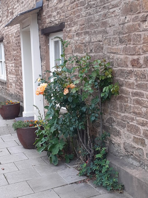
A. The railway crossingB. The signal boxC. Roses on NorthgateD. Roses on NorthgateE. Roses on NorthgateF. House on Northgate
The first picture is of the listed Midland Railway bridge and level crossing (Picture A) a source of endless frustration to drivers, and, as the location of the meeting of five roads, a horribly hazardous place for pedestrians. There must be a better way of doing traffic management here. Picture B is the Midland Railway Signal Box, which was the inspiration for the Hornby Railway model. Turning along Northgate, there are three pictures of rose bushes (Pictures C to E), some cultivated, some not. but in early summer their cumulative effect is striking. Picture F is of a house a little further along Northgate, with a wonderful display of creepers and climbing foliage.
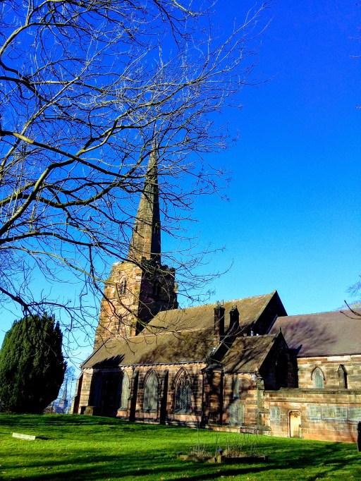
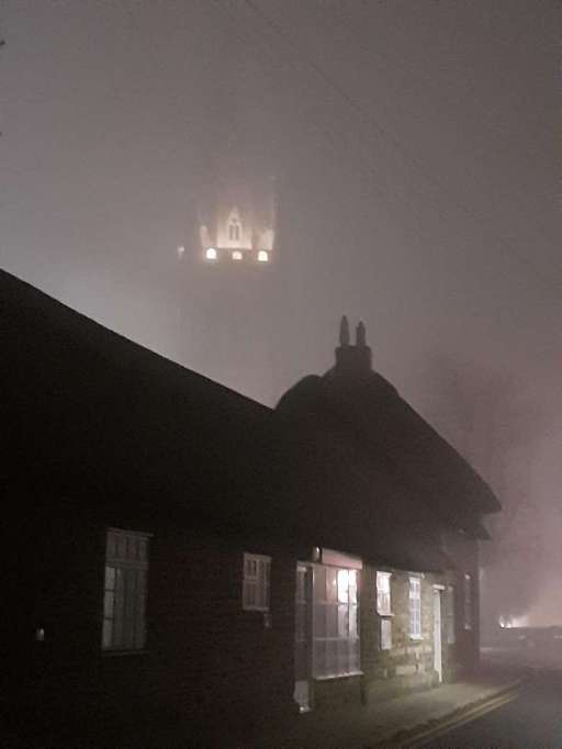
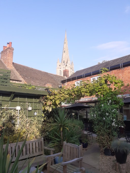
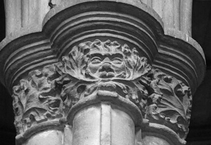
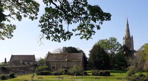
G. All Saints Church through the mistH. All Saints Church from the Wheatsheaf gardenI. Green Man carving in All Saints ChurchJ. Possible Anglo-Saxon cross at All Saints ChurchK. Castle Great Hall, Old School and Church from Cutts CloseL. Castle Great Hall, Church and Old School from Castle grounds
The next six photos all figure All Saints Church in one way or another. Picture G is a photo taken from Northgate on a misty evening where all that can be seen of the tower is a small floodlight area. The thatched cottages on Northgate can be seen in the foreground. Picture H shows the spire of the church from the garden of the Wheatsheaf pub opposite on a pleasant summer afternoon. Picture I (from here) shows the Green Man stone capital within the church – one of a series of wonderful capital carvings I have blogged about elsewhere. Picture J shows a possible Anglo-Saxon Saxon cross built into the south porch of the church. The identification is very speculative, but the cross is very similar to other, demonstratively, Anglo-Saxon examples. Pictures K and L shows t wo views of the Castle Great Hall, Old School and Church, from Cutts Close and the Castle grounds. I have argued elsewhere that these might be an indication of an early church group in the area. Click on the pictures to see the full extent of the photographs.
M. Ghost sign on Catmose St.N. Ghost sigh on Mill St. O. The Old Drill Hall on Penn St. P. Houses on Penn St. Q. Pedestrian bridge over the railway at the end of South St. R. The chapel of St. John and St. Anne
Pictures M and N show two nice examples of ghost signs from Catmose Street and Mill Street – faded, painted signs indicating a former usages. Picture O shows the Old Drill Hall on Penn Street which is impressive despite looking as if it could do with a bit of TLC. Picture P, also on Penn Street shows row of houses with a pleasing skyline. South Street Railway Bridge (Picture Q) is hardly beautiful, but very functional ,offering a way over the railway for pedestrians old and young, cyclists, mobility scooters, prams, shopping trolleys etc. For obvious reasons it is know in my household as the “slow bridge”. Finally Picture R (from here) shows the chapel of St John and St Anne – a medieval foundation serving the sheltered housing around it. It is the only place I know where the minister presiding at communion can watch, through the west window, the tops of passenger and freight trains passing within a few yards of the outer wall.#
Further posts on aspects of Oakham can be found using the button below.
Amended on 8th May 2024 to include further details of Our Lady’s Well.
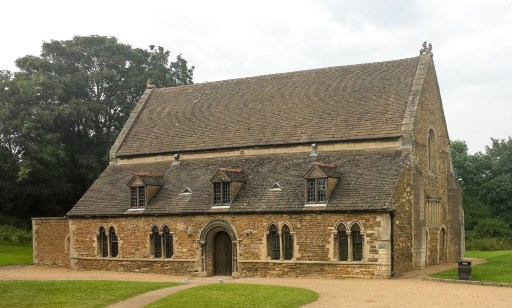
In her book describing the architecture and liturgy of the Anglo-Saxon church in England (1), Gittos describes, in some detail, the existence of what she calls “church groups”. By this she means the practice of constructing a number of churches close to each other in some sort of relationship, which can be demonstrated archaeologically at a number of sites around England, primarily from the early Anglo-Saxon period. These usually take the form of two or more churches aligned on one axis (usually approximately east / west), sometimes with other churches on a parallel axis a few hundred metres away. The alignments can also include crosses or other monuments. Typical examples can be found at St. Augustine’s Abbey in Canterbury, with the linear group of St Peter and St Paul, St Mary and St Pancras and the non-linear groups at Hexham and Ripon. These are of course from a monastic context. Gittos hypothesizes that these churches were used for different aspects of the liturgy, with processions between them. A similar linear arrangement can be shown to have existed at the secular Yeavering site.
Figure 1. All Saints Oakham (from the south)
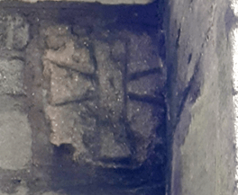
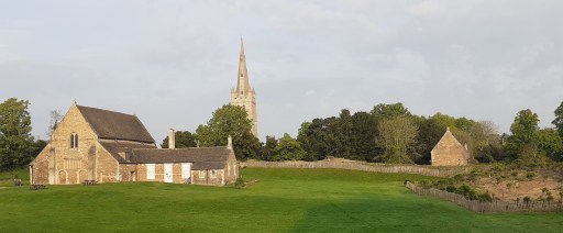
Readers of my blogs will know that I recently moved to Oakham in Rutland and have become a member of the parish church of All Saints (Figure 1). In looking at the layout of the church and its environs, it seems to me that there are some topographical hints (and I would put it no stronger than that), that this was the site of an Anglo-Saxon church group. The oldest part of the current church, the south porch, visible at the left of the photograph of figure 1, dates from around 1190, but the church almost certainly stands on the site of an Anglo-Saxon predecessor (2). In the wall of the south porch, there is what was thought to be a consecration cross, but it is visually very similar to the one shown in Gittos (p 239) from Earls Barton in Northamptonshire, that is demonstrably Anglo-Saxon (Figure 2). If the Oakham cross is Anglo-Saxon, it was presumably taken from the Anglo-Saxon church in the rebuilding of the late 12th century.
Figure 2. The crosses at Earls Barton (left) and All Saints Oakham (right)
All Saints now consists of a nave, transepts and chancel, with side chapels to either side of the chancel – dedicated to the Holy Trinity to the north, and to the Virgin Mary to the south. The original Norman church just consisted of the nave with the current transepts, the latter acting as side chapels (the communion niches, which would have been next to the altars, can still be seen). The earlier Anglo-Saxon church was probably of similar shape and dimensions.
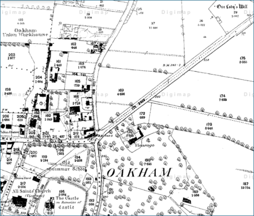
The first hint that the church might once have been part of a group arises from the fact that it lies within a substantial enclosure that now contains the Hall, inner bailey and outer bailey of Oakham Castle, as well as the church and church yard. This can be seen in Figure 3. The interesting fact is that the Great Hall of the Castle, regarded as possibly the best surviving example of Norman Domestic Architecture (Figure 4) lies fairly precisely on the same axis as the church, and eighteenth century maps show a postern gate in the wall on the alignment, offering access between the Great Hall and the church.. There seems to be no reason for these features, other than whatever was on the site before the hall was built was in some way associated with the church. Interestingly, early sources indicate that there was a chapel within the Great Hall (3) to which specific individuals held right of appointment, which suggests that it was more than simply a domestic chapel. One can thus conjecture that there was a church / chapel on this site before the castle was built in 1190.
Figure 3. The church and castle enclosure (from 1900 Ordnance Survey Map)
Figure 4. The Great Hall of the Castlefrom the south
The second indication that there was a church group comes from extending this alignment to the west. This takes it through the medieval site of Northgate, shown in Speed (4) as a large open area with a small drawing of a cross on a plinth (Figure 6). Whilst the cross is somewhat south of the strict alignment (although due west of All Saints), its presence is again suggestive. Note that alignment of the church and the castle shown on the map is not accurate and does not represent the situation on the ground. The area around Northgate was bisected by the building of the Midland Railway in the 1840s and, if the Speed map is accurate, the location of the cross was at the position of the current signal box. This is itself a grade II listed building and the prototype for model railway signal box construction kits (Figure 6). Whether or not this is enough to make up for the loss of the cross must be left for the reader to decide.
Figure 5. The Speed map of Oakham (the cross can be see on the left of the picture)
Figure 6. Oakham signal box at the site of the Northgate Cross
The third hint is the building to the north of the church, but on a roughly parallel axis that can also be seen in Figure 3. This is the original Oakham Grammar School, dating from just after the Reformation. It is built on the site of two former Guild chapels – one dedicated to St Mary, and one to St Michael the Archangel (3). The former included a toft, possibly the Guild Hall, and the latter at least was quite substantial, having dimensions of 60 feet by 30 feet. (3). Their topographical relationship to All Saints echoes that at Hexham and Ripon, referred to above. Perhaps here we have survivors of other ancient chapels that were part of the overall church group. Figure 7 shows a modern (i.e. May 2024) photograph of the castle (on the left), the old school (in the centre) and the church of All Saints (on the right) from the north side of Cutts Close Park (once the outer bailey of the castle). Visually they form quite a striking arrangement.
It also seems that there were another two pre-Reformation guilds at All Saints – one dedicated to All Saints itself, and presumably centred on the high altar, and one to the Holy Trinity, presumably centred on the chapel of that name within the church itself. How the Guild chapel of St Mary relates to the chapel with the same dedication in the church itself is not clear.
Figure 7. The castle, old school and church
Reference (3) also indicates that there were pre-Reformation processions to a well dedicated to St Mary a “quarter of a mile to the north of the church”, and to an image of St. Michael, possibly within the chapel of that name – another of the characteristics of church groups identified by Gittos. The well still exists. It is shown on the 1880 and subsequent Ordnance Survey maps as “Our Lady’s Well”, actually almost half a mile north east of the church (Figure 8) with a straight path across Cutts Close and the Burley Road forming a direct and prominent link between the church and the well. It is not currently accessible being in an overgrown area managed for wildlife. Our Lady’s Well and All Saints church are on quite an accurate midwinter sunset / midsummer sunrise alignment. Whether or not this was intentional I will leave for others to judge. If it was then it suggests some sort of ritual activity at the site that predates the Anglo-Saxon era.
Figure 8. Our Lady’s Well and All Saints Church (from an 1880s OS map – the church is in the bottom left and the well in the top right).
At this point it is also worth noting that there is another surviving chapel in Oakham – that of the medieval Alms Houses of St. John and St Anne. This is however, not on the same alignment as the cross, church and castle and is some distance to the south west, and not likely to be part of any group. Neither is it in any sort of solar alignment with All Saints, being too far north to lie on the All Saints / Lady Well alignment. But the dedication is rather odd and perhaps hints at an earlier history.
So we can conjecture that we have here the surviving topography of a church group, with one church on the site of the current church in a linear alignment with one on the site of the Castle Great Hall and a cross at Northgate, and two on the Old School site where the guild chapels once stood. A church or chapel on the site of the current chancel of the church of All Saints is also a possibility. In making this suggestion we are of course making major assumptions that all the current buildings stand on the site of Anglo-Saxon originals, for which the evidence, such as it is, is very weak. There is also no evidence that there was ever monastic activity at Oakham, which seems to have been the context of many early church groups. So the suggestion that we have here the remains of a church group, attractive as it is, must only be regarded as very speculative.
References
Gittos H (2015) Liturgy, Architecture, and Sacred Places in Anglo-Saxon England, Oxford University Press, 978-0198737056
Aston N (2003) All Saints’ Oakham. A guide and history. Friends of All Saints, Multum in Parvo Press.
Speed J (1611) Theatre of the Empire of Great Britaine. Modern version by Nigel Nicolson (1998) The counties of Medieval Britain. A Tudor atlas by John Speed. Pavilion Books Ltd.
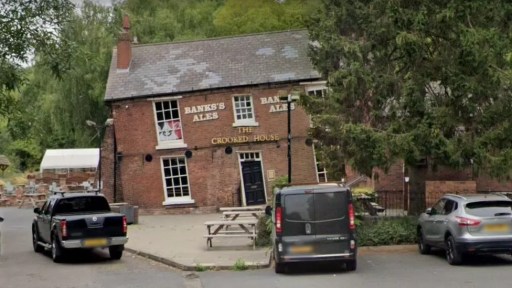
This is the second of two blogs that set out a timeline of the destruction by fire and subsequent demolition of the Crooked House in Himley in early August 2023, through links to local and national press reports. It covers the period from January 2024 onwards. Earlier news items can be found in the first blog here.
In the days after the fire, there were many, very similar, press reports and thus there has been a need to be selective. In what follows, I thus use three main sources.
BBC local and national news websites, which was, and continues to be, the most comprehensive source.
The Express and Star website, which gives a local perspective. Note that many of the articles that are linked require free registration to be read.
The Guardian website – although many national newspapers reported the story in early August, the Guardian’s was probably the most comprehensive and, through its columnists, the most reflective.
I also include articles from other sources where they complement the above, including a few from overseas to demonstrate the reach of the story. I will update this list at intervals over the coming months.
In addition to the news links, there are two Facebook pages that contain news and (often robust) comments covering a range of opinion.
In histories of specific places in the Black Country, the first paragraph often begin in a similar way to that of (1) with regard to West Bromwich.
“Of the pre-conquest history of West Bromwich, we know practically nothing.”
There are a number of reasons for this lack of knowledge, but perhaps the main one is that much of the evidence of the remote past has been destroyed in the rush to industrialisation in the eighteenth and nineteenth centuries. That being said, I want to show in this blog, that by considering evidence from a wide variety of sources over the entire region, it is possible to say something about the pre-Domesday history of the area, even if only in the broadest outline.
I will look at the material that exists chronologically – the stone ages, bronze age, iron age, the Roman period and the Anglo-Saxon period, before looking in a little more depth at the Domesday record itself. But we begin by defining an area of study.
Defining the Black Country before it was black.
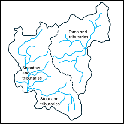
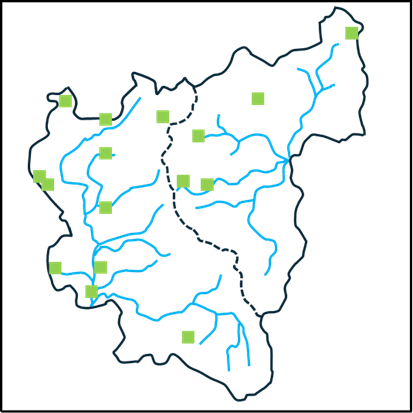
The first question that arises is what area we should consider? The concept of the Black Country as such is of course a creation of the 19th century, and even today, there is no consensus on its extent. Some would argue that it is confined to the area of the South Staffordshire coalfield, others that it is the area of the current boroughs of Dudley, Sandwell, Walsall and Wolverhampton. The status of places around its periphery are argued over endlessly (and vehemently). The only consensus is that Birmingham isn’t part of it. But none of these definitions are of relevance to the period before Domesday, when the area was wholly rural. So, in what follows, I have chosen major natural features to define the area of interest – basically the catchments of the upper Stour and Smestow, and of the headwaters of the Tame. These are shown in Figures 1a and 1b, with the former identifying the rivers and the latter showing the position of the major modern towns in the area. The catchment maps are taken from (2) and (3). It should be noted, that as with everything else in the Black Country, the precise locations of the streams shown in these figures owe a great deal to human activity and may well have been different in the periods we are considering. The boundary between the two catchments, shown by the dotted line, is a continuation of the Pennine chain – the major watershed of England, at this point dividing the headwaters of the Rivers Severn and Trent. The area chosen corresponds roughly to what most would define as the Black Country, although they contain sizeable rural areas to the west in the modern South Staffordshire district and to the south, in north Worcestershire and do not contain the Smethwick and Handsworth areas. This will not please all readers, but a least offers a geographically consistent area – and indeed on that will be seen proves historically useful to consider. It has the potential to offend almost everybody!
(a) (b)
Figure 1. Definition of the study area: a – river catchments, b – location of modern towns.
The Stone and Bronze Ages
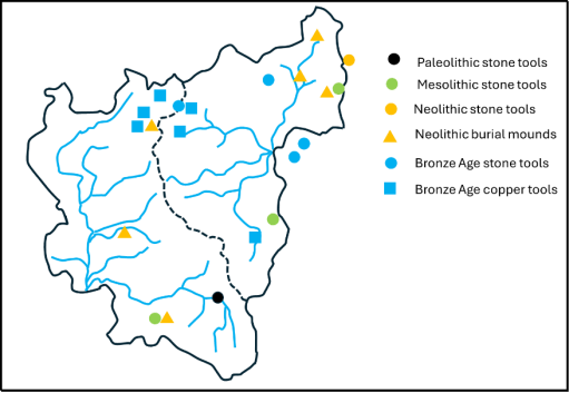
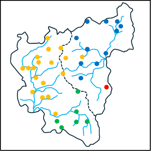
Reference (4) gives an excellent overview of archaeological finds in the area of the Black Country from the Palaeolithic era through to the Roman period. The information presented there is summarised in the map shown in Figure 2 for the Palaeolithic (950,000-9500 BC), Mesolithic (9500-4000 BC), Neolithic (4000-2400 BC) and Bronze Ages (2400-700 BC). (4) gives more detail of the various finds, and only some broad points will be made here. The first and most obvious is that the majority of finds lie just outside the modern urban area to the northeast and the south, or in rural enclaves within it (such as the Sandwell Valley and Barr Beacon). This is almost certainly due to the destruction of archaeological material by industrialisation. Secondly however, there do seem to be a couple of clusters -one in the Aldridge area around Castle Old Fort, and one on the watershed around Wolverhampton. But the huge time period under consideration needs to be borne in mind – these finds were from a wide variety of periods. Nonetheless they do suggest that there was some limited habitation of the area in the prehistoric periods.
Figure 2. Archaeological finds in the Stone and Bronze ages drawn from information in (4).
The Iron Age
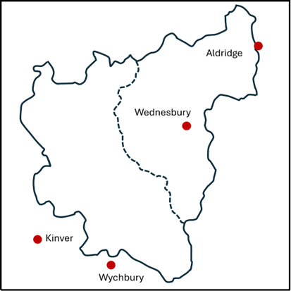
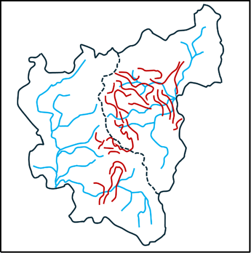
Now let us turn our attention to the situation in the Iron Age before the Roman invasion (700-43 BC). There is in fact very little that can be said with any certainty. However, there are a small number of hill forts in the area – three just outside the study zone at Wychbury in the south (4) Kinver in the southwest (5) and at Castle Old Fort near Aldridge in the northeast (6). There was also probably one at Wednesbury within the study area, although the evidence for this is recent and probably not conclusive (7). These are shown on Figure 3 and three of them seem to line up nicely in a southwest / northeast direction. The spacing along the line suggest that there may also have been one at Dudley on the boundary between the catchments, the traces of which will have been long obliterated by the castle. The configuration suggests a defensive alignment – but who was defending what from who is not in any sense clear. Copper horse bridal fittings have also been found at Wychbury and Castle Old Fort (4).
Figure 3. Iron Age hill forts.
The Roman Period (43 BC – 400AD)
The first truly historical fact about the area that can be relied on is that there were a number of Roman army marching camps in the Greensforge area (8) – see Figure 4. In total there seem to have been two auxiliary forts and five marching camps, which can be dated to the early years of the Roman invasion (45AD to 80AD). They were probably used as the Roman army pushed north and west into England, but also seem to have an intensive period of occupation around the Bouddican revolt of 60AD. These camps were short lived, and there is no evidence of occupation after about 80AD. There is however some evidence of civilian occupation close to the site near Camp Hill, throughout the Roman period (8). An intensive network of roads also remained. These linked into the major arteries of Watling Street to the north and Ryknield Street to the east (figure 4). The importance of Greensforge seems to have been as a ford over the River Smestow. The roads that converge there can be identified with some confidence are as follows (9).
1. A road to the south, to the salt producing areas at Salinae, modern day Droitwich.
2. A road to the north to Pennocrucium, modern day Water Eaton, on Watling Street.
3. A road to the northwest to the major city of Viroconium (Wroxeter), with a branch to Uxacona (Redhill), again on Watling Street.
4. A road to the west to Bravonium near Leominster –presumably with a crossing of the Severn near Quatford, south of Bridgnorth.
Figure 4. Roman Roads in the Black Country
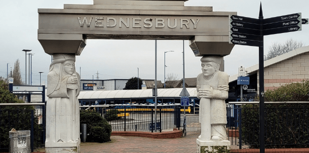
All of these roads can be traced, at least in part, on modern maps and on the ground. Note that the roads from Salinae, through to Viroconium, and onwards to Chester, formed a major “saltway” for the transport of that precious commodity. In addition, the existence of another road can also be indirectly inferred. – from Letocetum (Wall) on Watling Street, south of Lichfield, possibly via Wednesbury before passing through The Straits in Sedgley (another name often linked with Roman Roads) and then heading for Greensforge (10). A further road that probably ran northwest from Metchley in the south to Pennocrucium on Watling Street, can be traced on the ground at its southern and northern ends. Thus, it is likely that there were two roads crossing the Black Country from southwest to northeast and southeast to northwest, that would have crossed in the vicinity of Wednesbury. The precise line of these roads has again been obscured by industrialisation.
Such a road network would form an important focus for both military and civilian business, and as noted above, it is more than likely that there was some sort of small-scale occupation at Greensforge throughout the Roman period. One might expect something similar in the Wednesbury region.
In terms of Roman political structures, the Black Country sat close to the boundaries of three civitas or tribal territories – those of the Cornovii in the upper Severn Basin, the Dobunni in the lower Severn basin, and the Corieltauvi, largely in the Trent basin. Although it is not possible to be sure of the boundaries, the territory of the latter was probably to the east of the main English watershed that passes through Sedgley and Dudley. In addition, it is likely that this ridge was also the boundary of two of the late Roman provinces – that of Britannia Prima to the west and Flavia Caesariensis to the east. (4) reports that a Dobunnic coin has been found at Lutley in the south of the study area.
Many modern historians of that period would see continuity between these civitates and late Iron Age tribal groupings, which would place the Black Country on the boundary between three different tribal groups. Thus, in general terms, the Black Country before and during the Roman period would seem to have been a border zone between different tribal groupings, but nonetheless well traversed by both the invading Roman armies and the traders that would have followed in their wake.
The Anglo-Saxon period (400 -1066 AD)
After the Roman armies left Britain in the early firth century, the traditional view has been that the native Britons were gradually pushed westward into Wales and Cornwall by the military force of invading Anglo-Saxon armies and a number of Anglo-Saxon kingdoms were established. Over the last few decades, a great deal of archaeological evidence has emerged to show that it was a lot more complicated than that. There were undoubtedly migrations of Germanic speaking people from Europe, firstly in the service of the native British population and later in conflict with them. But there is also much evidence of continuity of agricultural practices and political systems that are simply not consistent with a wholesale replacement of one people by another (11, 12), Genetic evidence, which needs very careful interpretation, suggests that there is a broad similarity of genetic background of all peoples across England and Wales, although there are some very distinctive local genetic variations that could possibly be linked to specific migrations (13). Similarly, there is evidence that the replacement of the Celtic British language (old Welsh) by a Germanic form (proto-old English) was not a uniform process with some limited evidence emerging that Germanic languages were spoken in England during the Roman period (14), and of the survival of pockets of British speakers across England into the 9th and 10th centuries (11).
So, we have a very complex picture emerging of the movements of peoples and languages across England in the immediate post Roman era. What can be said with a little more certainty is that there were significant movement of people in the second half of the sixth century, when the early Anglo-Saxon kingdoms come into view, with evidence of migration from the east to the west (15, 16). In my view this was probably triggered by the climate cris caused by large volcanic explosions in 536 and 543, and by the arrival of the bubonic plague (the Justinian plage) at about the same time (17).
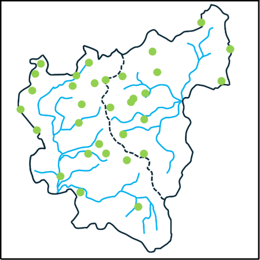
But what does this say about the Black Country in that period? Here we turn firstly to place name evidence. Within our study region most names undoubtedly have an Anglo-Saxon origin. But there are some that are or earlier, British or even older origin. Some of these relate to geographical features – the Rivers Stour, Smestow or Treasle, and the Tame, and the hill names of Barr and Penn (3). Just to the west of the study area there are a number of British names – Kinver, Morfe and possibly Quatt, whilst inside our study area we have Compton (containing the root Welsh cwm for valley) and Walsall, the first component of this being a British name. These names again suggesting that the Black Country in this period was something of an ethnic and linguistic borderland. When we come to the English names, there are two clusters that stand out – those names containing the component “leah”, meaning woodland clearing, and those containing the component “tun” meaning settlement or dwelling. These are shown in figures 5a and 5b. The former strongly suggest that these names originate from a migration of English speakers into a forested area in which they created their own smallholdings and settlement.
(a) (b)
Figure 5. Place name elements: a – leah, b – tun.
Moving on, can anything be said about the political and social groupings in the area? There is strong evidence that two of the Roman Civitas in the area morphed onto territories or kingdoms with Anglo-Saxon names – the Dobunni to the south became the Hwicce and the Cornovii to the west became the Wroecansaete. From the early seventh century most of our study area was part of Mercia, and indeed the Hwicce and the Wreocansaete were absorbed fully into Mercia by the end of that century. The boundary between the Hwicce and Mercia can be traced from the Diocesan boundaries between Worcester and Lichfield, which date back to the late seventh century when they were set up as dioceses to serve the two kingdoms. In our study area, this boundary passes along the Stour, with the Hwicce to the south and Mercia to the north, although the area around Dudley seems always to have been in Worcester diocese. This in turn was matched by the county boundary when the counties were formed in the tenth century. The boundary between Mercia and the Wreoconsate in the early Anglo-Saxon period seems to have been along the Severn to the west of the Black Country – indeed the tenth century county boundaries of Staffordshire extended as far as the Severn. North of our study area, the boundary seems to correspond to the modern county boundary between Staffordshire and Shropshire which follows the watershed between the Trent and the Severn. The incorporation of the area west of the Black Country to the Severn into Mercia would have given them direct access to Bridgnorth – which at that time would have been near the head of the navigable waters of the Severn, and thus accessible by ships from Bristol and beyond, and would offer considerable trading opportunities.
In a charter of 854 relating to the boundary of lands near Cofton Hacket in Worcestershire, preserved in Hemming’s Cartulary, a particular point is described, on the boundaries of the Worcester and Lichfield dioceses, that is a boundary between the Tomsaete, and the Pencersaete (18) and possible with the Arosaete (19). It is generally accepted that the Tomsaete were a Mercian people associated with the River Tame, and indeed this point is at the southern edge of the Tame catchment. Similarly, the Arosaete, who are mentioned in the Tribal Hidage (20), are regarded as the inhabitants of the valley of the River Arrow, in the territory of the Hwicce (19). Again, this point is at the northern end of the Arrow catchment. Cyril Hart has argued that this implies that the Pencersaeten were a people to the north and west of this point, and he suggest they were a Mercian tribe, centred on Penkridge, to the north of Wolverhampton (19). This seems to have become the accepted identification and can be found in a number of texts. Clearly the name suggests that there might be some association with the Penn / Pensnett area, and if the tribe were centred in Penkridge, then this area would certainly be included. However, the author remains unconvinced by this identification. If it were true this would imply that the Pencersaete extended across two catchments – that of the Stour / Smestow which flow into the Severn, and that of the Penk in the upper reaches of the Trent catchment. This seems to the author unlikely, and not consistent with the other tribal boundaries in the area, with the probability being that the bounds of the Pencersaeten extended only over the Stour / Smestow region i.e. just one catchment, and probably centred on the Penn region.
There is another interesting possibility concerning the Hwiccan territory. Green (20) notes that there is a cluster of names with components relating to the Hwicce in Rutalnd in the East Midlands, and speculates that this might be the region from which an Anglo-Saxon tribe called the Hwicce migrated westward in the later sixth century. If this was the case, we could see this tribe as assuming power in the former area of the Dobunni, and the area becoming associated with its name. As I said, the situation concerning migration / kingdom formation etc is very complicated.
At least in the early part of the Anglo-Saxon period, the Roman roads would have remained in use, and probably for many centuries after that. No doubt they were used by those engaged in both commerce and warfare during this period, as they passed by the growing settlements in the area. There were a couple of occasions however when there was more substantial activity. In 893 the Great Heathen army of the invading Vikings marched from near the River Lea north of London to Bridgnorth, where presumably they were met by others coming up the Severn from the Bristol Channel (21). The most obvious way would have been up Watling Street to Wall, then along the proposed road through the Wednesbury area to Greensforge and thence on to Bridgnorth. The passage of the army, with its associated foraging, might have been an uncomfortable experience for those living in the area. Then again in 910, a Viking army moving north out of Bridgnorth was pursued by the combined Mercian and Wessex forces and overtaken and defeated in the Tettenhall area (22). Again, one might expect the route of both armies would have involved the road network passing through Greensforge.
In response to Viking attacks on Mercia. King Alfred’s daughter Aethelfleda and her husband built defended settlements or burghs across Mercia, one of which is reputed to be at Wednesbury (23). However no hard evidence of an early fortification has been found at Wednesbury- but this hasn’t stopped the council from erecting a statue of Aethelfleda at the entrance to Wednesbury bus station – see the header to this blog.
The Conquest and Domesday (1066 – 1086 AD)
When we come to the Domesday survey, we have for the first time detailed information about our study area. Domesday lists 38 manors in our area and these are shown in figure 6 – from the excellent compilation of (24). The colours in this figure indicate the administrative region in which the manors fall – yellow for Seisdon Hundred in Staffordshire, blue for Offlow Hundred, again in Staffordshire, green for Client Hundred in Worcestershire and blue for an entry in Northamptonshire Domesday. It can be seen that the boundary between Seidon and Offlow hundreds basically follow the watershed, although a couple of Seisdon manors (Ettingshall and Bilston) fall into the Tame catchment. The boundary between Client is Worcestershire is along the Stour as would be expected from the Diocesan and County boundaries, with Dudley to the north. The Northamptonshire entry is for (West) Bromwich – which seems to have been included by mistake with its Lord’s entries in that county.
Figure 6. The Domesday manors
The Domesday book also contains much factual information about each manor. However, as all who use this information will know, the details need to be treated with some circumspection. It was compiled from oral evidence by many different people and there are many inconsistencies in the way the data was collected and is presented. This is particularly true of the numerical data for the hidage (originally a measure of area, but by the time of Domesday also a fiscal assessment), the number of ploughlands (the area that could be cultivated by one person) and the number of plough teams. There is however more consistency in the information about Lordship in 1066 and 1086, and the number of workers in various categories (25), and this information is shown in table 1 below. This shows the number of workers in each manor in 1086, in the following categories.
Free men with on average about 30 acres of land and two plough oxen;
Villagers of Villeins, unfree and bound to the Lord but with similar holdings to Free Men;
Smallholders of Bordars, unfree with about 5 acres of land and use of the communal plough team;
Cottagers, unfree with very meagre land holdings;
Slaves, owned by the Lord;
Priests.
The Lords in 1066 and 1086 are also given. The manors are ranked in terms of total number of workers. This order is perhaps surprising to modern eyes. Of the major modern industrial towns in the area, only Wolverhampton is near the top of the list in terms of population. The others – Wednesbury, Dudley, West Bromwich, trail behind, and one, Walsall, is simply not present in the list. The major centres in the area at Domesday were Sedgely, on the watershed between catchments, and Halesowen to the south. Many of the manors had very few workers of any sort. Of those workers the Villagers were the most common, accounting for 56% of the total, which is in line with the larger English picture. 11% of the population were slaves – a perhaps somewhat shocking statistic to modern eyes – with the major concentrations in Halesowen, Wolverhampton and Wombourne. The number of priests is small at 6, and one suspects must be an underestimate. The overall number of workers is 580. Allowing for a household size of 5, which seems a reasonable assumption, gives a total population somewhere around 3000. Even if the Domesday survey omits sections of the population, or if the assumed average household number is too small by a large factor, the population is tiny in comparison to the current population of the Black Country boroughs, which is something over 1 million.
The effect of the Norman conquest on land ownership is starkly clear. In 1066, the major Lords were King Edward with 11 manors, the Canons of St Mary’s Wolverhampton (now St Peter’s) with 5, and Countess Godiva with 3. There were 14 other Lords. By 1086, the number of Lords had been reduced to four. In the main the lands of King Edward had passed to King William; the Canons of Wolverhampton had retained their manors (although one suspects that by then the body of Canons had been thoroughly Normanised) and the Bishops of Chester had retained their single manor. The rest were now under the Lordship of William Fitz Ansculf, who held 98 manors in total across the country, centred on his castle at Dudley. As elsewhere in England, we see how revolutionary and far reaching the Norman takeover was.
Free
Villagers
Small holders
Slave
Priests
Total
Lord in 1066
Lord in 1086
Halesowen
4(a)
42
23
10
2
77
Wulfwin
Earl Roger
Sedgley
45
2
3
1
51
Earl Algar
William Fitz Ansculf
Wolverhampton
6
30
14
50
W’ton St Mary
W’ton St Mary
Bloxwich
16
11
1
28
King Edward
King William
Shelfield
16
11
1
28
King Edward
King William
Wednesbury
16
11
1
28
King Edward
King William
Wombourne
14
3
8
1
26
Thorsten
William Fitz Ansculf
Bushbury
15
2
2
19
Countess Godiva
William Fitz Ansculf
Crockington
14
4
1
19
King Edward
King William
Essington
15
2
2
19
Countess Godiva
William Fitz Ansculf
Kingswinford
14
4
1
19
King Edward
King William
Swinford
5
11
2
1
19
Wulfwin
William Fitz Ansculf
Pedmore
3
10
4
1
18
Thorger
William Fitz Ansculf
Cradley
4
11
15
Wigar
William Fitz Ansculf
Dudley
1
3
10
2
15
Earl Edwin
William Fitz Ansculf
(West) Bromwich
10
3
13
Brictwin
William Fitz Ansculf
Ettingshall
9
3
12
Thorsten
William Fitz Ansculf
Wednesfield
6
6
12
W’ton St Mary
W’ton St Mary
Bilston
8
3
11
King Edward
William Fitz Ansculf
Himley
8
3
11
Ravenkel; Wulfstan
William Fitz Ansculf
Orton
7
2
2
11
Wulfstan
William Fitz Ansculf
Upper Penn
8
2
1
11
Earl Algar
William Fitz Ansculf
Trysull
4
1
5
10
Thorgot
William Fitz Ansculf
Rushall
6
2
8
Vithfari
William Fitz Ansculf
Willenhall
5
3
8
King Edward
King William
Amblecote
4
2
1
7
Earl Agar
William Fitz Ansculf
Compton
4
3
7
King Edward
King William
Tettenhall
4
3
7
King Edward
King William
Lower Penn
1
6
6
Countess Godiva
William Fitz Ansculf
Lutley
2
1
2
5
W’ton St Mary
W’ton St Mary
Bradley
4
4
Untan
William Fitz Ansculf
Oxley
4
4
Alric; Godwin.
William Fitz Ansculf
Seisdon
2
2
King Edward
William Fitz Ansculf
Bescot
0
King Edward
King William
Chasepool
0
William Fitz Ansculf
Haswic
0
W’ton St Mary
W’ton St Mary
Pelsall
0
W’ton St Mary
W’ton St Mary
Tipton (b)
+Chester
+Chester
Totals
6
327
182
65
6
580
Table 1 Domesday manors from (24). ( a- Specified as Riders , b- Part of the Bishop of Chester / Lichfield manor. Breakdown of workers not given. )
A look beyond Domesday
Before closing, there is perhaps one further point that is worth raising. Ultimately it was the geological wealth of the area that resulted in its transformation in the eighteenth and nineteenth centuries, and specifically its coal reserves. But the coal didn’t suddenly appear in that era – it was there all the time and in many places there were surface outcrops. The locations of these are shown from the Coal Authority web site (26). It is very likely that these resources were exploited on a small scale from the Roman period onwards. The major transformation of the area came in the last few hundred years, but the seeds of that transformation were being sown well before Domesday.
Figure 7 Coal outcrops from (26).
References
Dilworth D (1973) “West Bromwich before the Industrial Revolution”, Black Country Society ISBN 0 9501197 9 2
Green C (2020) “Britons and Anglo-Saxons: Lincolnshire AD 400–650”, Studies in the History of Lincolnshire, History of Lincolnshire Committee ISBN 0902668269