Rutland and the Hwicce

Introduction

The articles by Phythian-Adams (1977,1980) from several decades ago, and the more recent one by Green (2016) have highlighted the rather odd fact that within Rutland in the East Midlands, there are a number of place names that refer to the Hwicce, an Anglo-Saxon tribe whose territory was in the West Midlands, particularly in Worcestershire and Gloucestershire. In this short blog I firstly rehearse some of the findings of these authors and then extend the discussion somewhat, presenting some further, although tenuous, evidence of links between Rutland and the Hwicce based on consideration of the early Anglo-Saxon document known as the Tribal Hidage, and on estate holdings at the time of Domesday.

Place names

We begin by setting out the place name evidence as outlined by Phythian-Adams and Green. They showed that there are a number of place names in Rutland that strongly suggest an association with the Hwicce .These ae as follows.

  • Witchley Warren/Wicheley Heath  – a farm in Edith Weston, but originally covering a significantly larger common area;
  • Withley East and Witchley West hundreds – the extensive area in the south of Rutland, that was included in the Northamptonshire Domesday;
  • The village of Whissendine in the north west of Rutland;
  • Witchley Leas on Whissendine parish.

In addition, around 20 miles to the south in Northamptonshire there is the parish of Whitson. A full discussion of these names, including their earlier forms is given in Green (2016) and their association with the name of the tribe of Hwicce is clear.

Topography and the Tribal Hidage

In an earlier blog I have shown that the current area of Rutland, plus the area around Stamford, matches fairly closely the catchment of the Upper Welland, whilst the catchment of the Glen, which joins the Welland below Stamford corresponds to at least the southern part of the Lincolnshire district of Kesteven. After the junction of the Glen and the Welland, the Welland flows towards Spalding – the territory of the early Anglo Saxon tribal grouping of the Spalde on the margins of Fenland . This was an extensively managed area, with well-defined common rights (Oosthuizen, 2017). In particular the control of water levels was vital to the pastoral economy, and thus the amount entering the area from the Welland was of crucial importance. This level of importance, and the fact that the two catchments of the river became well defined administrative areas, argues for their early definition as coherent units. Taking this further, I suggested that these land units corresponding to Kesteven and Rutland could be identified with the East and West Wixna of the Tribal Hidage (Hart, 1971), the first of 300 hides and the second of 600 hides, where the hide is an economic rather than a geographical measure. The reason for this assertion was that, in the listing of the Tribal Hidage these polities came between the Spalde and the South and North Gyrwa, which are known to be in the Peterborough area*. Although I am neither a linguistic nor a place name expert, it seems to me that the name of Wixna is also possibly associated with the name of Hwicce, and suggests that at the time of the production of the Tribal Hidage, which I take to be in the early seventh century following the argument of Higham(1995) at least part of the Hwiccan peoples populated the areas of Rutland and Kesteven.

*I also made the alternative suggestion that Rutland Kesteven could be identified with the East and West Willa, with names that are cognate with Welland, but on reflection I think their location in the list of the Tribal Hidage makes this less plausible.

Domesday and Queen Edith

It is well know that in 1066, Queen Edith, the wife of Edward the Confessor, held much of what was to become Rutland in Lordship, particularly in the southern Wycherley hundred, which was then part of Northamptonshire. However these were far from her only land holdings. The full extent of them is revealed through the analysis of the Open Domesday web site (Open Domesday, 2023), and shown on the map of Figure 1 below.

Figure 1. The Domesday holdings of Queen Edith (from Open Domesday)

The holdings where Edith was either Lord or Overlord, are shown by small red circles. There is a general dispersed group of holdings scattered across the north London / Oxford / Milton Keynes area, with further scattered holdings across the south Midlands. There are, however, a number of clusters. The Rutland cluster is indicated by the red circle labelled as A. The largest cluster is in the Herefordshire / Worcestershire area and is labelled B, with smaller clusters around Grantham (C) and Horncastle (D), with a further scatter across north Lincolnshire. Cluster B is of particular interest, as this lies in the western part of the territory of the Hwicce, which extends through Worcestershire and Gloucestershire. More specifically it lies within the territory of the Magonsaete, an early polity about which little is known (Pretty 1989), but which is sometimes referred to is referred to as the western Hecani – probably another name for Hwicce. Thus, we possibly have here another instance of Edith, as the Queen of England, and the successor of the Mercian Queens, as having much land in the predominantly Hwicce area, providing another link between the Hwiccan lands of Rutland and the larger Hwiccan kingdom in the west.

But what of the other clusters – can any Hwiccan connection be demonstrated between these and the Hwicce? Here the evidence is tenuous at best. The holdings around Grantham are in the Wapentake of Winnibriggs. This something of an odd name, and Coates (2009) would see it as a compound of a personal name and a bridge. I would make the very tentative suggestion however that this might be associated with the Hwicce, but this is very speculative. With regard to the Horncastle cluster, I can find no relationship at all with the Hwicce in terms of place names. For both however, it may be that historians of the locality may be able to identify any connection if it actually exists.

One further, tenuous connection exists between the Northampton shire village of Whitson mentioned above (which does have a Hwiccan association) with the isolated Queen Edith holding of Finedon. These are in the same area of the county, about 10 km apart. I will leave it to the judgement of the reader as to whether or not any weight should be placed on this.

References

Coates R (2009) “Reflections on some major Lincolnshire place names. Part Two: Ness wapentake to Yarborough”, Journal of the English Place Name Society, 41, 57-102

Green C (2016) “The Hwicce of Rutland? Some intriguing names from the East Midlands”, https://www.caitlingreen.org/2016/03/the-hwicce-of-rutland.html

Hart C (1971) “The Tribal Hidage”,  Transactions of the Royal Historical Society, Fifth Series, 21 (1971), 133-157

Higham N (1995) “An English Empire – Bede and the early Anglo Saxon kings”, Manchester University Press.

Oosthuizen S (2017) “The Anglo-Saxon Fenland”, Windgather Press

Open Domesday (2023) https://opendomesday.org/name/queen-edith/

Phythian-Adams C (1977) “Rutland Reconsidered’ in Ann Dornier, ed., “Mercian Studies”, Leicester, 63-84

Phythian-Adams C (1980) “The Emergence of Rutland and the Making of the Realm“, Rutland Record 1, 5-12

Pretty K (1989) “Defining the Magonsaete”, in The origins of Anglo Saxon Kingdoms ed S Bassett

The Anglican Lectionary at Christmas – A seasonal rant

Calendars

The Anglican lectionary (and indeed the lectionary of all other churches) operates with two basic calendars; a lunar calendar centred on Easter (which is defined by the Passover new moon) from Ash Wednesday, forty days before Easter, through to Pentecost, fifty days after Easter, and Trinity Sunday a week later; and a solar calendar for the rest of the year. These move relative to each other with Easter occurring from late March to late April. But there are further lower-level calendars in use. Firstly, there is what one might call an agricultural calendar – the quarter days that have gained some religious significance (Christmas obviously at the midwinter solstice, but also Lady Day at the spring equinox in March, the feast of St John the Baptist at the midsummer solstice in June, and Michaelmas at the Autumn equinox in September) and between these festivals there are those that seem to have grown out of agricultural practices and possibly reflect ancient Celtic festivals but have again been given a Christian identity – Candlemas at the start of February (Imbolc), May Day (Beltaine), Lammas at the start of August (Lughnasa) and All Saints / All Souls (Samhain) at the start of November. Secondly we have post biblical Saints Days, usually celebrated on the day of their death and thus fixed to the Solar calendar.

With all of these, I have absolutely no problem – they are all in some way natural – indeed one might say God given and reflect the way the world is, and the days God chose to call his saints to heaven.  But there is another low-level calendar reflected in the lectionary – that of church tradition. These are of two basic types – traditional church seasons and themes for particular Sundays that have their basis in fossilized church practice rather than scripture; and the identification of specific days for biblical saints, such as the apostles for whom no death dates are known, again fossilized through church tradition. With these calendars I do have significant issues – mainly because of their imposition on the more natural calendars, and the distortion of the lectionary that results from this, that, to my mind, obscures the telling of the biblical story and the proper appreciation of the overall gospel narrative., which I see as the prime role of any church lectionary. I will illustrate this by describing the period in the church’s year when I get particularly annoyed about this, from All Saints at the start of November to Candlemas at the start of February, which effectively mark the start and end of the winter season.

All Saints to Candlemas in the current lectionary

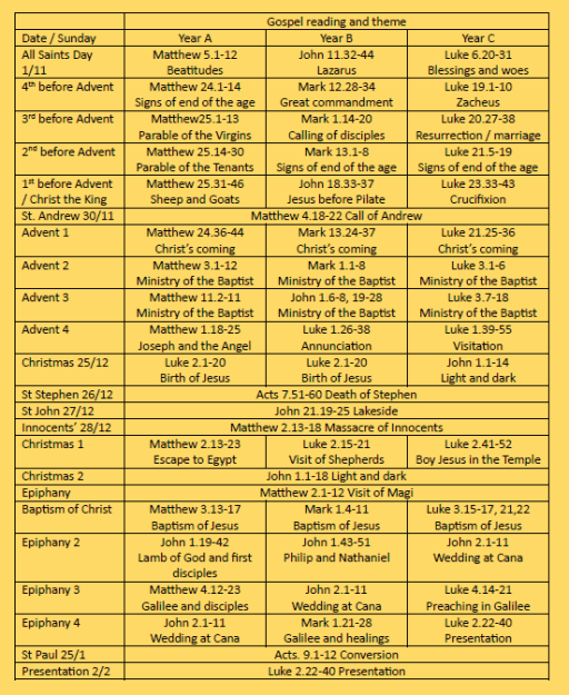
Table 1 shows the leading bible reading from the Lectionary and the themes of these readings (which are almost always the Gospel) for each of the three liturgical years, for Sundays and major festivals. The period covered is from All Saints to Candlemas.

In the run up to Christmas, Advent is a season of preparation for both the first and second comings of Christ. There are a number of “themes” that have been used over the centuries. The oldest are the traditional Advent themes are death judgement, heaven and hell. Sensibly to my mind, the modern lectionary looks at these themes, although not explicitly, in the period between All Saints at the start of November and the week before Advent Sunday at the end of November / start of December. For two of the three years (A and C), the gospels are the Blessings / Woes from Matthew and Luke, presumably describing “saintly” qualities. For year B however, the gospel, perhaps oddly, is the raising of Lazarus from John’s gospel. These days, All Saints is more frequently observed on the Sunday nearest November 1st, and the readings for the 4th Sunday before Advent are often not used because of this. For the 4th to 2nd Sundays before Advent, years A and C follow the apocalyptic discourses in Matthew and Luke, whilst year B has two rather random readings from Mark, before returning to the Markan apocalypse on the 2nd Sunday before Advent. The Sunday before Advent (around the end of November) is celebrated as the feast of Christ the King, a quite recent addition to the liturgical calendar from 1925, which for all the merits of the theme, does disrupt the sequence of readings. Year A continues the Matthean apocalypse with the parable of the Sheep and the Goats, which also matches the Christ the King theme, but Years B and C use passion readings from John and Luke – the kingship of Jesus being demonstrated on the cross. To complicate matters further the feast of St Andrew occurs on November 30th, with the leading reading being his call from St. Matthew’s gospel. On Advent Sunday, the apocalyptic theme returns in all years, with readings from Matthew, Mark and Luke. Overall, in years A and C, there is a coherent set of readings, whilst year B is a bit of a mish mash. Christ the King however badly disrupts the sequence in years B and C.

More recently the themes for the four Sundays in Advent have been enumerated as the Patriarchs, the Prophets, John the Baptist and the Virgin Mary and these form the basis for many “Advent candle songs” with verses describing each of these themes being sung at the lighting of the Advent Candle during Sunday services. More recently a set of more anodyne themes that might be thought more appropriate to our current age have become to be used – hope, peace, joy and love. And on top of all of these we have the current lectionary provision – the second coming on Advent Sunday, John the Baptist (his ministry rather than his birth) on Advent 2 and 3, and the Annunciation, the Visitation or the appearance of the angle to Joseph on Advent 4. Congregations are thus often left to sing an Advent carol song which has no relationship at all to whichever of the different themes are being used, so confusion is added to the utter lack of literary or musical merit usually found in these songs. They should be confined to a liturgical dustbin in my view. More seriously, the lectionary does not in any way reflect the birth narratives in Matthew and Luke, which have a well-defined structure and need to be read as a whole. In picking and choosing passages, and not including all the birth narratives of Jesus and John in Matthew and Luke, the current situation obscures the basic thread of scripture that describes the coming of the Christ child.

The Lectionary gives the two basic readings for Christmas itself as Luke 2.1-20 (the birth and the coming of the shepherds) and John 1.1-14 (the majestic reflection on the pre-existence and incarnation of Christ and the light overcoming the darkness). I have no issues with this. After Christmas, however, things get decidedly messy. December 26th and 27th are taken up with two biblical saints’ days for St Stephen and St John, and any clergy that have the energy to celebrate them after the pre-Christmas silly season, must rapidly change gear to completely different periods – those of the Acts of the Apostles, and the post resurrection appearances of Jesus. Then on the 28th, there is the feast of the Holy Innocents – well in advance of the Epiphany reading of the coming of the Magi which was the cause of the slaughter. This confusion is only ameliorated by the fact that these feasts are seldom observed due to the post-Christmas fatigue of clergy and congregations.

This confusion continues on the Sundays after Christmas. On the first Sunday there is a somewhat random set of nativity and infancy readings – the flight to Egypt, a repeat of the visit of the shepherds to the birth with verses added referring to the Circumcision of Christ, celebrated 8 days after Christmas on January 1st, and the story of the boy Jesus in the temple in Jerusalem, all of which defy any sensible chronological sequence. On the second Sunday after Christmas (which seldom occurs in reality), John 1 is again read in all years.

The feast of the Epiphany on January 6th arose in the eastern church in the second or third century. The main reading is the coming of the Magi to Jesus, but it has also gained associations with other themes – in particular the wedding at Cana in Galilee and the Baptism of Jesus – an infancy story and two stories from the start of Jesus’ ministry, giving a chronological nightmare, within the service itself. These days, Epiphany is usually commemorated on the first Sunday in the new year rather than on January 6th itself.  The Baptism of Jesus by John the Baptist is usually celebrated the Sunday after Epiphany and repeats some of the pre-Christmas material featuring the Baptist. On the next three Sundays, there is much repetition of these themes together with the other stories around the start of Jesus’ ministry – his teaching in Nazareth, and the call of the disciples, depending on liturgical year. In year B, there are again some rather random readings from St. Mark’s gospel.  On 25th January, the feast of the Conversion of St Paul is scheduled – again requiring a liturgical leap between the early part of Jesus’ ministry and events that occurred perhaps 5 to 10 years later. The modern “Week of Prayer for Christian Unity” is scheduled for this period just to complicate matters.

Finally, we come to the Feast of the Presentation of Christ in the Temple (Candlemas) on February 2nd. It is placed 40 days after the birth and as such represents the time between birth and purification in New Testament times – but in Lectionary terms, we jump back from the start of Jesus’s ministry to just after his birth. Confusion all around.

So all in all, the current lectionary is a bit of a mess, that doesn’t properly allow the gospel stories of the birth and early ministry of Jesus to be told. This largely due to what can be called the traditional calendar that, for reasons of church tradition places various events in a rather random order, particularly after Christmas, but with considerable chunks of the nativity story omitted and repetition of some material – particularly concerning John the Baptist.

But is there another way? I turn to that in what follows.

Table 1 Current lectionary provision

A revised lectionary from All Saints to Candlemas

In what follows I set out a lectionary scheme that, I believe, allows the gospel narrative to be heard clearly. It is really an exercise in vanity – I am not, and never will be, in any position to impose this on a congregation or on the wider church (for which I suspect there are many reasons to be grateful) but putting it together has been an interesting diversion. I make the following assumptions.

  • The proposed lectionary shown in table 2 is, other than on Christmas Day, based entirely on Sundays – as in reality that is the only time when congregations gather in any number, and we count the Sundays as either before or after Christmas.
  • Three gospel accounts are used – Matthew (year A), John (year B) and Luke (year C). The material in the gospel of Mark has been used and expanded by Matthew and Luke, and its inclusion would only lead to repetition.
  • As far as possible, the gospel accounts are read in the order in which they occur in scripture. This means that the traditional placement of some of the pre- and post-Christmas material is changed, and that the traditional calendar is ignored completely.
  • I do not include any of what might be called “community” services in the period considered – such as All Souls, Christingle, Crib and Carol services – which will take on forms appropriate to the communities to which they are offered, including parts of the nativity story. Rather I concentrate on the services appropriate to the regular, worshipping congregation.
  • Some of the suggested gospel readings are longer than would currently be expected, and novel ways of reading them might be required – perhaps to have two gospel readings at the expense of Old and New Testament readings?

So let us now consider table 2. The proposed lectionary begins with All Saints on the 8th Sunday before Christmas, with the readings being either the Matthean or Lukan Beatitudes (as in the current lectionary) or a passage from John 15 where the writer urges Christians to love one another – all three setting out the behaviour of saints.  The readings for the 7th to 4th Sundays before Christmas then follow either the Matthean or Lukan apocalypses, read in the order in which they are written, or John 14 and the early part of John 15. These thus allow the consideration of the traditional advent themes of death, heaven, hell and judgement, with the readings for the 4th Sunday before Christmas being suitable for what would be Advent Sunday. I chose the readings from John, as they set out the “realized eschatology” of that gospel, which is an important strand in the overall gospel story. The readings for the next two weeks, the 3rd and 2nd Sundays before Christmas, are the same for all lectionary years and allow the telling of Luke’s stories of the announcement and birth of John the Baptist, the Annunciation and the Visitation in an ordered way. The Sunday before Christmas is again the same for all years and includes the genealogy according to Matthew (which in my view is a vital, and usually neglected, part of the gospel story) and the appearance of the angel to Joseph. The readings for the last three Sundays before Christmas are all long and may need to be split – although the Magnificat and the Benedictus could be omitted in the provision of the 2nd Sunday before Christmas and used as songs / canticles of worship within the service. Taken together, the provision from All Saints onwards allows effectively a seven-week advent. It does, however, make a bit of a mess of the Advent candle and Advent wreath traditions, which would need reinventing if they are to be used within what is proposed.

The provision for Christmas Day (including the late-night service on Christmas Eve) is the story of Jesus’ birth from the first half of Luke 2. Immediately after Christmas, there is no provision for St Stephen, St John or the Massacre of the Innocents. Perhaps the major change to current provision occurs on the Sunday after Christmas, where the reading for all three lectionary years is the second half of Luke 2, which covers the Circumcision, and the Presentation in the Temple. Again, the Nunc Dimittis could be omitted and used elsewhere in the service. The reading for the second Sunday after Christmas is the visit of the Magi, the massacre of the Innocents and the flight to Egypt. Its timing is consistent with the timing of Epiphany, so the old order has not been completely overturned.

For the next three Sundays, there are separate readings for the lectionary years – from Matthew in year A, John in year B and Luke in year C as before. For the 3rd Sunday after Christmas, the readings are all accounts of the ministry of the Baptist and the Baptism of Jesus, and for the following two Sundays, they include accounts of events in the early ministry of Jesus –  the temptation of Jesus in the wilderness, the calling of the disciples, the early preaching in Galilee and the wedding at Cana – all read in the same order as in the gospel account. The Temptation reading is of course traditionally associated with the start of Lent (thus producing yet another chronological fault in the current lectionary) – we will consider this a little further below. The year C Christmas 3 reading is long – including both the passages on the Baptist and Baptism, and also the Genealogy. The latter is, however, an important part of the narrative and to some degree acts as an epilogue to the nativity story. Only one part of Luke’s account is omitted – the story of the boy Jesus in the temple (Luke 2.41-e). This could be included as a second reading for Christmas 2 but would result in an awkward mix of gospels for that day.

The final Sunday coincides with the timing of Candlemas, and the reading suggested for all three years is the majestic opening of John 1, with its meditation upon the themes of light and darkness, as a summing up of all that has gone before. The traditional candle ceremonies would be wholly appropriate here.

Table 2. Revised Lectionary provision

Other thoughts

Some other thoughts arise.

  • In the proposed lectionary, I have made no attempt to include Old or New Testament reading, but there are many such that could be assigned which would fit the various themes. In particular sequences for the seven Sundays before Christmas based on Isaiah or the Advent antiphons would be appropriate.
  • Having attempted to remove the festival calendar from the All Saints to Candlemas period, where should the displaced feasts go? Some of them (the Massacre of the Innocents and the Circumcision) have actually been incorporated into the scheme of readings, but there are also the biblical saints’ days – St Andrew, St Stephen, St John and St Paul – what should happen to these? I would suggest that a fresh approach to such festivals is required – the assigned dates are quite arbitrary in any case. One possibility would be a weekly lectionary of one saints day or festival per week that could be used at a midweek service (say between Pentecost and All Saints) at an appropriate time for a specific congregation.
  • The traditional reading for the start of Lent is that of the Temptation, that has been used in mid-January, in its proper gospel context, in the proposed lectionary. I have never been a great fan of Lent (it being part of the traditional calendar), but if a period of reflection before the passion is required based on Jesus’ journey to Jerusalem, then in my view the appropriate starting point for this would be the story of the Transfiguration.

Concluding remarks

In this post I have set out my irritations with the current lectionary provision, particularly for the Sundays around Christmas. In my view, the overlapping calendars that are in use, and the way in which a wide variety of different passages are read week by week, serve to obscure the gospel story and do not do justice to the narratives themselves. I have proposed something that I would find more appealing. However I suspect that not all would agree with my views, and that for many the current mix and variability of the readings are a glorious kaleidoscope of scripture through which God speaks to them. Such folk will of course, probably quite correctly dismiss all that I have written!

The origin of Rutland

Preamble

The study of local history is often a very personal affair. I recently moved from Lichfield to Oakham in Rutland, and have thus naturally become interested in the local history of the area, about which I previously knew very little. In particular the early, pre-Domesday, history of the area intrigues me. The nature of the now the county of Rutland in that period is far from clear. At Domesday in 1086 (1), it was divided between “Roteland” – the two northern wapentakes of Alstoe and Martinsley, which were recorded as a detached part of Nottinghamshire, and the southern hundred of Witchly, which was part of Northamptonshire (Figure 1 – from (2)). In a detailed study Phythian-Adams (3,4) argued that there was a deeper underlying unity and that Martinsley and most of Witchley formed the dower lands of late Anglo-Saxon queens, and possibly Mercian queens before that; and that a royal hunting forest stretched over these two regions. He hypothesized that the division of the region took place during the Viking period in the ninth and tenth centuries and this division was incorporated into the newly formed counties in the area in the late 10th and early 11th centuries. In addition, the whole region is also remarkably free from Danish place names, despite being firmly within the sphere of influence of the Five Boroughs of Lincoln, Nottingham, Derby, Leicester and Stamford, again suggesting a shared history of some sort.

Figure 1. Rutland at Domesday (from (2))

(1 indicates Alstoe Wapentake; 2 is Martinsley Wapentake, and the remaining area is Witchly Hundred.)

Be that as it may, Phythian-Adams was unable to make much headway into the origin of the land unit that was to become Rutland prior to the Danish invasions. He suggested that it might be a small polity similar to those listed in the area of Middle Anglia in the Tribal Hidage (5), that most enigmatic of documents that I have discussed elsewhere, but was unable to say any more. He also demonstrated that there were a number of settlement names on the western county boundary that could be interpreted as watchtower / beacon or something similar, suggesting a contested boundary with whatever polity lay to the west.   In addition, he noted that where the Roman Road known as Ermine Street crossed the county boundary, there were significant Roman settlements at Great Casterton and Thistleton. Roman towns on boundaries seems to have been a characteristic of the Roman east midlands, possibly to control the boundaries of different tribal areas, which again suggests that the Rutland area had an identifiable identity at that period as a sub-region of the Corieltauvi tribal area.

In this blog post we revisit this issue of the early origin of Rutland through rather a different approach – by looking at the topography and river catchments of the area, and the interaction with the eastern fenland tribal areas that have been extensively studied by Oostthuizen (6). We will conclude that in these terms, the areas that were to become Rutland and the Lincolnshire “Part” of Kesteven formed two coherent neighbouring territories with rivers that drained into the highly managed fenland boundary and the polities of the Tribal Hidage that existed there and were important in maintaining the fenland habitat. In addition, a VERY speculative reanalysis of the Tribal Hidage gives two possibilities identifications of these territories.

Topography

Figure 2. The Welland catchment

Figure 2 shows a map of the catchment of the River Welland, produced by the Welland Valley Partnership (7). On it we have superimposed

  • the boundaries of the modern County of Rutland and the Lincolnshire area of Kesteven (dotted red lines)and the location of the town of Stamford (red circle);
  • the tentative boundary of the Tribal Hidage region of the Spalde (around Spalding) – Oostthuizen suggests that this represented by the hundred of Elloe in the Lincolnshire part of Holland.
  • The locations of the western “defensive” settlements mentioned above (green circles).

It can immediately be seen that the Martinsley and Witchly areas of Rutland, together with the area around Stamford, is effectively the area of the major part of the Upper Welland catchment and its tributaries, the Eye, the Chater and the Gwash, with the exception of a relatively narrow strip to the south of the Welland. The position of Stamford just outside Rutland in a narrow strip of Lincolnshire has frequently been noted as being anomalous, and consideration of a number of late Anglo-Saxon estate holdings suggest it was once part of the Rutland with significant estate links to the area. In topographic terms, the boundary between Rutland and Kesteven would make much more sense if it were to the east of Stamford. The defensive settlements can be seen to be at the upper end of the catchment, close to the watershed.

 The area of Kesteven contains the catchment of the Glen that feeds into the Welland below Stamford. The Welland then feeds in to the fenland region of the Splade. This is of some significance. Oostthuizen shows that this area was heavily utilised for agriculture, with communal rights to use specific areas of the Fen for grazing. There are indications of the control of rivers and drainage channels in this and other fen boundary areas. This is of importance, as it implies that the Spalde would have every incentive to ensure some degree of control of the contents of the Welland and its tributaries, particularly in times of drought and flood, to ensure the productivity of their region. Thus, the two areas of Kesteven and Rutland would have been of some importance to the fenland economy of the Spalde, which points to the need for some sort of level of organization, either as separate polities, or as upland extensions of the territory of the Spalde, even if only with the status of a modern drainage authority. This in turn suggests that the origin of these two areas could arise from their topography as important catchments for the fenland economy. There is an anomaly here however – the wapentake of Alstoe is outside this catchment, with its streams flowing to the Soar and the Trent. Taken with the fact that this area was not part of the lands of the Anglo-Saxon queens, or of the Royal Forest, tends to suggest that it was not part of the original land unit.

But can we say any more about the nature and names of these two areas of Rutland and Kesteven? To that question we now turn.

The Tribal Hidage

I have discussed the nature of the document known as the Tribal Hidage elsewhere – see here and here. Almost everything about this document is disputed in one way or another and great care needs to be taken in its interpretation and any conclusions that are drawn from it must be viewed with some circumspection. In its various versions, it consists of what was probably a Mercian or Northumbrian tribute list of various polities of a wide range of sizes (Table 1 reprinted from here), some of which can be identified and located, whilst the locations of others are disputed. It is arranged in two lists – a primary list and a secondary list, both, as far as can be judged proceeding a roughly clockwise direction (Figure 3 reprinted from here). Its date is as uncertain as any other aspect of the document, but for me the early date of around 620 proposed by Higham (8) seems the most logical.

Table 1 The Tribal Hidage

Figure 3. The order of the primary and secondary lists in the Tribal Hidage

Now in the primary list we have, at P7 and P8, the south and north Gyrwa. These can be located with some confidence in the Peterborough area, around the River Nene. The Spalde are at P11. Between The Gyrwa and the Spalde at P9 and P10 on the list, we have the East and West Wixna. These have not been located, with some writers placing them around Wisbech or the Norfolk edge of the fen to the east. However, their position in the list would suggest a location between the Gyrwa and the Spalde. As these two polities bordered each other, this is a bit tricky, but to identify them with Rutland and Kesteven is broadly consistent with the order of the list.

But there is another possibility. As mentioned above, the Tribal Hidage consists of two lists. In the Primary list, after the Hicca at P16, which can be located around Hitchen, there is the Whitgara. In the map of figure 3 I did not suggest a location for this. However, in the view of some scholars, such as Hart (5) this is an obvious reference to the Isle of Wight. In placing the unknown entities of P18 and P19 (Noxgaga and Ohtaga) in the Leicestershire / Northamptonshire area, I conveniently ignored this suggestion (on the basis that if some evidence doesn’t fit, it is best ignored – which I observe is a common practice of historians!). But if in fact the identification with the Isle of Wight is accepted, this means that the Primary list has two parts – the rotation round the north of Mercia, and then possibly three large entities in the south – Wight, Noxgaga and Ohtaga added on at the end. This would match with the suggestion of Hart who placed the latter two in the Surrey / London area. Pushing this line of reasoning a little further for the Secondary list, if this was again in two parts, we would have a rotation around the south and east of Mercia, and then a list of major subject kingdoms beginning with East Anglia running around the east and south of England. This in turn opens up the possibility of not having to consider placing S7 to S10 in the South Midlands in order to proceed from S6 (Faerpingas) in Oxfordshire to East Anglia (S11) in a reasonably logical way, but they could be allowed to be in the East Midlands where there is something of a hole on the map. Of particular interest are S9 and S10 – the East Willa and the West Willa. Hart places these in southern Cambridgeshire and argues that the name Willa is cognate with the name of the Well stream, a major waterway in the area. An identical argument could apply for polities next to the River Welland ie Rutland and Kesteven. However , the chain of assumptions is a long one, and this identification should be regarded as very speculative.

Concluding remarks

A consideration of the topography of the Welland Catchment, suggest that this may have been what defined the boundaries of what were to become Rutland and Kesteven. In the early Anglo-Saxon era, both these polities would have been important to the economy and agriculture of the Fenland boundary, and especially the region of the Spalde. In addition, it seems possible that we could identify Rutland and Kesteven with the Tribal Hidage polities of either the East and West Wixna, or the East and West Willa. Of these, the first two fit most naturally into the order of the Tribal Hidage, whilst the last two are most linguistically likely. But neither may be correct!

References

  1. Thorn F (1980) “Rutland Domesday*”, Domesday Book 29, series editor John Morris
  2. Prince Yuri Galitzine (1986) “Domesday Book in Rutland – the Dramatis Personae”, Rutland Record Society, ISBN 0907464 05 X
  3. Phythian-Adams C (1977) “Rutland Reconsidered’ in Ann Dornier, ed., “Mercian Studies”, Leicester, 63-84
  4. Phythian-Adams C (1980) “The Emergence of Rutland and the Making of the Realm“, Rutland Record 1, 5-12
  5. Hart C (1971) “The Tribal Hidage”,  Transactions of the Royal Historical Society, Fifth Series, 21 (1971), 133-157
  6. Oosthuizen S (2017) “The Anglo-Saxon Fenland”, Windgather Press
  7. Welland Valley Partnership (2013) “Enhancing the River Welland“,
  8. Higham N (1995) “An English Empire – Bede and the early Anglo Saxon kings”, Manchester University Press.

The Oak Farm (Crooked House) Mill and its watercourses

Updated to include new information 17/11/2023

Background

In the aftermath of the dreadful events at the Crooked House (or Glynne Arms) in August 2023 (the timeline of which I have documented here) my interests in the Oak Farm area were rekindled., and I wrote a blog post on the early history of the Glynne Arms that has been quite widely read. Perhaps the main insight to emerge from that post was to restate the often-missed fact that the Crooked House began life as a corn mill on the Oak Farm Estate owned by Stephen Glynne and evolved into a public house in parallel with the rapid industrialization of the estate in the 1840s and 1850s. This point was also made in a blog on the Black country Society site by Steve Roughton, who indeed argued that it was the existence of soft ground around the mill race that caused the building to tilt.  The Oak Farm Mill stood on the Himley Brook on the boundary between Kingswinford and Himley parishes, and was powered by water from the brook, stored in a mill pool to the east and released into a mill race before rejoining the brook some way to the west. It was not the only mill in the area. To the east (i.e. upstream) the Himley Brook was joined by the Straits Brook, that formed the boundary between Himley and Sedgley parishes. Just upstream of the confluence, the waters of the Straits Brook were stored in a large mill pond that operated the Coppice Mill, owned by the Dudley Estate. This mill pond extended north to beyond Askew Bridge on the road from Himley to Dudley and is named in some sources as Furnace Pool – allegedly the site of one of Dud Dudley’s experimental furnaces in the 1620s – and the water was used to power the furnace bellows.

In this blog post, we look specifically at the watercourses that supplied the two mills, and how it evolved through the decades. It will be seen that it leads to some speculations that, in the 1840s the original Oak Farm Mill was much modified, and perhaps moved, taking water from the upstream Coppice Mill pool rather than its own. It also suggest that the Crooked House as we knew it up to August 2023 dates from that period.

Mills and watwerwheels

Firstly, however, we need to consider the nature of the mill itself, and in particular the possible waterwheels that were installed. Wikipedia gives a useful article on this. Basically, there are two types of wheel (although with many variants) – overshot and undershot (see Figure 1). Both of these require a differential height (or head) of water – from a reservoir of mill pool upstream, to a mill race downstream. For overshot wheels, the water fills buckets on the wheel circumference and the potential energy in the water is transferred into rotational energy in the wheel. For undershot weirs, the fall of the water upstream of the wheel decreases its potential energy and increases its kinetic energy (and thus its velocity), some of which is transferred to rotational energy in the wheel when it impinges on the vanes. A simple analysis indicates that the power output of both types of wheel is proportional to this height difference raised to the power of 1.5. Of course, the greater the head, the larger the wheel would need to be to extract the power, and the greater the mechanical challenge. The power from the wheel would have been suitably transmitted through gears to grindstones to produce flour from the cereal grains (see Figure 2 for an example from Cumbria). The miller of course would like to have a long period of operation of the wheel, but as water is released to the wheel, the level of the upstream mill pool will fall and the head available and hence wheel power will also fall. At some point the water level will fall below the level of the outlet weir or pipe in the reservoir. Thus, there is an advantage in having a large reservoir from which large quantities of water can be abstracted without too great a fall in the water level. There is no indication which type of wheel was present at the Glynne Arms.

Figure 1. Types of water wheel

Figure 2.  Heron Corn Mill, Cumbria

The Oak Farm Mill up to 1840

Moving on now to consider the development of the Mill and its watercourses, we will use a number of maps from a variety of sources. Each of the maps represents the same geographical area, and the buildings of the Mill / Glynne Arms are outlined in red, and the watercourses highlighted in blue. In their original forms, some of the maps did not have north at the top in the normal way, so these have been rotated, but the orientation can only be regarded as approximate. Figure 3 is an extract from the 1822 Fowler map of Kingswinford parish. The Oak Farm Mill was just outside the parish, so its appearance on the map is perhaps fortuitous. It is depicted as a simple L shaped building. The mill pool (A) is fed by the Himley Brook to the east (B) and itself feeds both the mill race (C) and the downstream channel of the brook (D). C and D join again at a point downstream. Water would have been diverted along the mill race by a system of sluices when the mill was in operation. The line of the mill race passes under the southern end of the building, which indicates that the mill wheel is at the southern end of the building. The parish boundary is defined by the brook and passes through the centre of the mill pool. The Oak Farm estate was wholly agricultural at this time. As this is a map of Kingswinford parish, nothing is shown of the area to the north of the mill in Himley parish.

Figure 3. The 1822 Fowler Map

Figure 4, from the Kingswinford Tithe map, surveyed in 1839, shows a very similar situation. The Oak Farm Mill is however indicated by a simple rectangular structure over the line of the mill race.

Figure 4. The Kingswinford Tithe Map of 1839

The map of Figure 5 is an extract from a document that was clearly drawn for the owners of the Oak Farm Estate and is dated November 1840. This map was used by Steve Roughton in his blog mentioned above, and I am grateful for his permission to use it here. He originally obtained it from the Clwyd archives many years ago, presumably amongst the Glynne papers relating to their home in North Wales. I have to admit that this is not a place I would have considered looking for details of the Crooked House. This shows a similar situation, with rather more detail of the watercourses to the east (i.e. upstream) and to the north (in Himley parish). In particular the buildings of Coppice Mill (A) are shown in green, with a channel leading from their vicinity into the Himley brook at the top of the Oak Farm Mill pool. The Coppice Mill pool was to the east of the mill buildings and is not shown The Oak Farm Mill itself is now represented by three distinct buildings, which suggests that the simple rectangular form in Figure 4 might be a schematic rather than realistic representation. On the other hand it suggest that the two northern buildings might have been constructed around that period. The line of the mill race (B) passes to the south of the most southerly building suggesting that the waterwheel was on the south of that building. Mine shafts of Oak Farm Colliery can be seen to the south of the brook near the downstream end of the Oak Farm Mill pool (C).

Figure 5. The Oak Farm Estate map from November 1840

The Oak Farm Mill from 1841

Figure 6, dating from sometime in 1841, is an extract from the Himley Tithe map. It can be seen that there have been some changes. The channel from Coppice Mill pool seems to have been replaced by one leaving the Coppice Mill pool at the north western corner (A), presumably connecting by an underground sough to the new pool on the north side of the Oak Mill pool (B).  Alternatively these channels might simply represent construction phase of the new watercourse system that will be described below. This channel is distant from the Coppice Mill buildings and suggests that it is not intended as a channel to feed the mill, but rather to act as an overflow to the Coppice Mill pool, or to increase the flow to the Oak Farm Mill pool. There is perhaps an indication on Figure 6 of a channel corresponding to the mill race position (C), but this is not totally clear.  The Oak Farm Mill is again shown by a simple rectangular building – again probably a simple schematic representation.

Figure 6. The Himley Tithe Map from 1841

Figure 7 is an extract from a map that can be firmly dated to April 1849 that shows the whole Oak Farm Estate and may have been produced for when the Estate went on the market in that year. Is shows a similar situation to Figure 6 from 1841, although the shape of the mill pool is different and the small pool to the north no longer appears (perhaps because this wasn’t part of the Estate). The different buildings of the Corn Mill complex are individually shown.

Figure 7. Extract from Oak Farm Estate map of April 1849

Figure 8, produced for the Dudley Estate, has notes referring to the removal of some trees in 1849 and can probably be dated soon after that, perhaps the early 1850s, as the mill pool shape is similar to that of Figure 7.. The Coppice Mill race is clearer (A), and there have been some changes to the shape of the Oak Farm Mill pool (B). The major change, however, has been to the channel from the northern corner of Coppice Mill pool (C) which has now been extended as a surface channel with a sharp turn to approach Oak Farm Mill from a northerly direction (D). This looks to be a new mill race, bringing water from the higher Coppice Mill pool to the Oak Fame mill, which is here shown as a number of separate buildings, with the original mill building to the south. The change in direction would either have meant a complete rebuild of the original mill building to accommodate a new water wheel on its western side, or perhaps the relocation of the mill to the building to the north (the later public house) with a new mill wheel on its western side.  

Figure 8. Oak Farm and Coppice Mills in the early 1850s

Figure 9 is the Ordnance Survey map of 1882. The situation can be seen to have changed completely with the topography being much changed by mining and other industrial activities and the development of the railway network. The Coppice Mill buildings (A) , and the Coppice Mill pool no longer exists (B), although there is a stream running through its location that runs underground to a junction with Himley Brook. In place of the mill there is a branch of the Earl of Dudley’s railway. Similarly, the Oak Mill pool is now longer visible (C), and the Himley Brook has been channeled, and west of the Oak Farm Mill (now named the Glynne Arms) runs along the old Oak Farm Mill race (D). The eastern end of the Himley brook now presumably runs underground (E). The original (southern) Oak Fam Mill building is no longer visible.

Figure 9. The 1882 Ordnance Survey Map

The 1882 situation is mirrored on the current Ordnance Survey map (Figure 10) and satellite view (Figure 11), where no trace of the mills and mill pools can be seen.

Figure 10. The current Ordnance Survey map

Figure 11. The satellite view from Google Earth

Discussion

The main implication from the above discussion is that it is likely that, around 1841, significant works were carried out on the watercourses in the area, so that Oak Farm Mill was supplied with water from the Coppice Mill pool rather than its own mill pool. The reason for this was straightforward – this would have given a greater head of water, and thus enabled the waterwheel to produce more power for the process of corn grinding. In addition, the larger area of the Coppice Mill pool would have allowed for longer periods of water wheel operation. As there has been much change in the local topography since then due to mining and other activities, it is difficult to be precise about the magnitude of this increase in power, but an estimate can be made from the ground level heights obtained from, for example, Google Earth. The current ground level downstream of the Glynne Arms is around 84m above sea level (asl). Just upstream, in the region where the Oak Farm pool used to be, the current ground level is around 88m asl. At the site of the Coppice Mill the ground level is around 90m asl. The Coppice Mill pool extended beyond Askew Bridge on the road from Himley to Dudley. The ground level on either side of the bridge is around 98m, with the stream under the bridge a metre or so lower. There is thus a very considerable slope from Askew Bridge down to the Glynne Arms – which is of course the reason why two mills were built there.  From these heights we can estimate the following.

Water level in race at Oak Farm Mill                          84m

Water level in Oak Fame Mill reservoir                     88m

Water level in race at Coppice Mill                             90m

Water level in Coppice Mill pool                                 96m

Thus, the head of water available to the Oak Farm Mill was around 4m, and to Coppice Mill was around 6m. The full benefit of these heads would not be available because of head losses in pipes, and sluices etc, but we can estimate the available heads would be around 2m and 4m. Now if the waters in Coppice Mill pool were used to operate the Oak Farm Mill, the potential head available would be 12m. Much of this will be lost by the passage along the new millrace, but it would still be substantial – perhaps around 4m. This represents a doubling of the head available to the Oak Farm Mill, and, as the power is proportion to the available head to the power of 1.5, an increase in power of almost three times. Of course, a considerably bigger water wheel would have been needed to extract this power.

The provision of the Coppice Mill pool water to Oak Farm mill resulted in a ninety degree change in the direction from which the water was coming. As noted above this would either require a major change in the original mill building (the building at the south end of the building complex shown in Figure 8) to accommodate the change of direction and the installation of a larger wheel, or perhaps the construction of a new wheel on the western side of the main building (what was to become the Glynne Arms). Adding speculation to speculation, depending on the type of wheel that was used, this wheel might have rotated in a clockwise direction looking from the west.  Now Steve Roughton hypothesized that the main reason for the tilt on the Glynne Arms was due to the soft ground around the original mill raise to the south of the main building. It may thus be that the moment caused by any new waterwheel on the building would have been in the direction to encourage this tilt.

Finally, some further speculation. The early maps show the Oak Farm Mill as a simple rectangular or L shaped building lying to the south of the final location of the Glynne Arms. The current building does not appear on maps in a recognizable form till the 1840s. Thus it may be that the Glynne Arms building was constructed at this period, possibly as a replacement mill when the watercourses were modified. Certainly in the 1841 census, the occupier of the property, John Cartwright was referred to as a farmer, miller and beer house keeper, so the Oak Farm Mill buildings also served as a beer house. That being said, a number of sources give the date of the building of the Glynne Arms as a farmhouse as 1765 – although I do not know the primary source of that date. I suspect it refers to the date when the original mill was constructed.

Whether or not the speculation above has any merit, it is nonetheless clear that in the early 1850s, major construction work was carried out to increase the supply of water to the Oak Farm Mill, but that the new water courses were all swept away as heavy industry spread across the area in the later 1850s and 1860s.

The timeline of the Crooked House Affair (March to December 2023)

This is the first of two blog posts that set out a timeline of the destruction by fire and subsequent demolition of the Crooked House in Himley in early August 2023, through links to local and national press reports. This blog covers the period up to December 2023. Later reports can be found in the second blog post here.

In the days after the fire, there were many, very similar, press reports and thus there has been a need to be selective.  In what follows, I thus use three main sources.

  • BBC local and national news websites, which was, and continues to be, the most comprehensive source.
  • The Express and Star website, which gives a local perspective. Note that many of the articles that are linked require free registration to be read.
  • The Guardian website – although many national newspapers reported the story in early August, the Guardian’s was probably the most comprehensive and, through its columnists, the most reflective.

I also include articles from other sources where they complement the above, including a few from overseas to demonstrate the reach of the story.  I will update this list at intervals over the coming months.

In addition to the news links, there are two Facebook pages that contain news and (often robust) comments covering a range of opinion.

SAVE THE CROOKED HOUSE (LET’S GET IT RE-BUILT)

*Rebuild The Crooked House*

March to July 2023

10/3/23 BBC The Crooked House: Britain’s ‘wonkiest pub’ to be sold

28/3/23 BBC The Crooked House: Britain’s ‘wonkiest pub’ for sale for £675,000

28/7/23 Express and Star  ‘A great shame’ as Crooked House pub set to be redeveloped for ‘other use’

August 2023

6/8/23 BBC  The Crooked House: Fire rips through famed ‘wonky’ pub

6/8/23 Express and Star  Fire engulfs The Crooked House pub – flames and smoke seen pouring out of iconic building

6/8/23 Guardian Fire engulfs historic pub famed for being wonkiest in Britain

7/8/23 BBC ‘Questions need answering’ over Crooked House fire

7/8/23 Guardian Police ‘reviewing all evidence’ on cause of Crooked House pub fire

8/8/23 BBC Demolition of Crooked House pub unacceptable – council

8/8/23 Express and Star  Call to help protect pubs following Crooked House blaze

8/8/23 Guardian ‘It’s gobsmacking’: locals demand answers to demolition of Crooked House pub

8/8/23 Guardian West Midlands mayor calls for Crooked House pub to be rebuilt ‘brick by brick’

9/8/23 BBC The Crooked House pub fire and demolition controversy… in 52 seconds

9/8/23 BBC Crooked House: Fire at ‘wonkiest’ pub treated as arson

9/8/23 BBC Former Crooked House landlords appalled at fire and demolition

9/8/23 Express and Star  Detectives treating fire at Crooked House pub as arson

9/8/23 Express and Star  Calls to leave ‘no stone unturned’ in investigation into ‘wrongful’ demolition of The Crooked House

9/8/23 Express and Star  MP questions whether police knew about ‘wrongful’ demolition of Crooked House pub

9/8/23 Guardian The strange tale of The Crooked House tells a much bigger story

9/8/23 Guardian Staffordshire police treating fire at Crooked House pub as arson

9/8/23 Sidney Morning Herald British heritage pub destruction: Crooked House stood for 260 years. Now it’s a pile of rubble  

9/8/23 Construction News Crooked House demolition plant hire owner: “I’ve done nothing wrong”  

10/8/23 BBC Crooked House: Meeting over future of ‘wonkiest’ pub site

10/8/23 Express and Star  Poet Pam pens poem about the tragic demise of The Crooked House

10/8/23 Express and Star   Crooked House: How iconic pub helped people meet life partners, marry and enjoy life

10/8/23 Express and Star  Police confirm contact with Crooked House owners as arson probe at historic pub welcomed

10/8/23 Express and Star  Couple recall how Crooked House made wedding ‘best day’ – after initial venue burned down

10/8/23 Guardian Change planning laws to protect historic pub buildings, campaigners say

10/8/23 Daily Express Owners of ‘Britain’s wonkiest pub’ had history of gutting traditional pubs suggest claims

10/8/23 New York Times What Happened to Britain’s ‘Crooked House’ Pub?

11/8/23 BBC The Crooked House scandal ‘must be catalyst for change’

11/8/23 Express and Star  Crooked House: Advertising boss offers ‘handsome’ reward to whistleblowers

11/8/23 Express and Star   ‘A crime against the Black Country’: Crowds gather in anger at site of The Crooked House

11/8/23 Express and Star  The Crooked House listed application was being considered – body explains why new requests can’t be

11/8/23 Guardian Crooked House rebuild would be ‘very complicated and costly endeavour’

11/8/23 Guardian Other plans by Crooked House owners have caused anger in Midlands

12/8/23 Guardian ‘People are sick of having our heritage knocked down’: how the Crooked House saga became a state of the nation story

13/8/23 BBC The Crooked House: Mystery and anger surround wonky pub destruction

13/8/23 CNN The Crooked House was Britain’s wonkiest pub. Then it burned down

14/8/23 BBC Giddy the fire dog helping probe Crooked House arson attack

14/8/23 Express and Star  Crooked House: What we know about demolished building’s new owners

14/8/23 Guardian Yes, rebuild the Crooked House brick by brick – and buttress local planning, too

14/8/23 Constriction News  Crooked House demolition ‘does disservice to entire industry’

15/8/23 BBC Miniature Crooked House wins plaudits from across the globe

15/8 /23Express and Star  Remains of Crooked House pub fenced off as arson inquiry continues

15/8/23 Express and Star   The Crooked House: What we know about investigation into fire and demolition of famous pub

15/8/23 Express and Star  Wolverhampton man makes model replica of Crooked House for friend ‘gutted’ by blaze

15/8/23 Guardian The mystery of the Crooked House fire

16/8/23 Express and Star   Crooked House footpaths fenced off after police called to ‘activity’ at site

16/8/23 Express and Star  Rebuilding The Crooked House could take three years and cost millions, warns expert

16/8/23 Express and Star   MP urges public wanting answers about Crooked House pub to ‘be patient’

16/8/23 Guardian Crooked House owner linked to landfill that also went up in flames

17/8/23 Express and Star  Black Country real ale campaigners to step up pub protection after loss of The Crooked House

17/8/23 Express and Star   I want Crooked House to ‘rise from the ashes’ MP tells packed meeting

17/8/23 Guardian If only we’d had the vision to save the Crooked House

17/8/23 Washington Post Mystery surrounds burning of Crooked House, Britain’s ‘wonkiest’ pub

18/8/23 Daily Express Owners of The Crooked House pub jet off to Corfu as questions remain over demolition

19/8/23 Express and Star  Black Country artist completes striking painting of the night The Crooked House burned down

19/8/23 Irish Mirror Irish drug smuggler at centre of scandal over demolition of Britain’s ‘wonkiest pub’ – Irish Mirror Online Irish Mirror

21/8/23 BBC Crooked House: Protesters block road to destroyed landmark pub

21/8/23 BBC Crooked House: Glass engraver honours destroyed pub

21/8/23 Express and Star  Stand-off involving police and MP at site of The Crooked House after access blocked

22/8/23 Guardian Paranormal group keeps night’s watch on Crooked House pub site

23/8/23 Construction News Contractor claims to be salvaging Crooked House materials for reuse

24/8/23 BBC The campaigners working 24/7 to save the Crooked House                       

24/8/23 BBC Crooked House: Arson arrests in pub fire probe

24/8/23 Express and Star   Two arrested over Crooked House fire as West Midlands mayor again calls for pub to be rebuilt | Express & Star (expressandstar.com)

24/8/23 Guardian Two men arrested over fire at Crooked House pub in Himley

25/8/23 New York Times Two Arrested After Crooked House Pub Fire

25/8/23 Stuff (New Zealand) Two men arrested over suspected torching of ‘Britain’s wonkiest pub’

25/8/23 News.com (Australia) Two men arrested after fire at Crooked House pub

28/8/23 Express and Star  Crooked House campaigners renew pleas to rebuild ‘Britain’s wonkiest pub’ during live TV appearance on This Morning

30/8/23 Express and Star  CAMRA pushes for Asset of Community Value vote to protect remains of ‘vitally important’ Crooked House

31/8/23 Guardian ‘We’ve become one big family’: Camp Wonky continues watch of Crooked House site

September 2023

1/9/23 Express and Star  Contractors to move  off Crooked House site as ‘Ceremony of the Locks’ due to be held  

2/9/23 Express and Star  Crooked House campaigners explain round-the-clock vigil at site of demolished icon  

2/9/23 Express and Star  Thousands of bricks from The Crooked House are securely locked away in symbolic padlocking ceremony  

4/9/23 BBC Firm linked to Crooked House owner was taken to court

4/9/23 Independent Crooked House pub bricks locked away after being ‘sold for £50 on Facebook’   

4/9/23 Dudley News Man camps outside Crooked House pub to protect bricks  

5/9/23 Express and Star  Roofer who led work on Crooked House facelift describes heartbreak at seeing it demolished

6/9/23 BBC Derbyshire model maker creates miniature Crooked House pub

7/9/23 BBC Third arrest in Crooked House fire investigation

7/9/23 Express and Star   Third man arrested over suspected arson at Crooked House pub

7/9/23 Express and Star  MP Marco Longhi calls for parliamentary debate on fate of pubs like Crooked House

8/9/23 Express and Star  Third man arrested over suspected arson at Crooked House pub

9/9/23 BBC Can fire-hit Crooked House rise from the ashes?

10/9/23 Express and Star   Unofficial Crooked House camp left empty amid reports of clash at ruins of famous pub

11/9/23 BBC Probe as violence breaks out at Crooked House site

11/9/23 Express and Star  Woman hit by car and two assaulted at Crooked House site as police appeal for witnesses

14/9/23 BBC Man held after violence at Crooked House site

14/9/23 Express and Star  https://www.expressandstar.com/news/local-hubs/staffordshire/2023/09/14/west-bromwich-man-arrested-following-disorder-at-site-of-crooked-house-pub/

16/9/23 Express and Star  MP re-iterates support for Crooked House and support groups

21/9/23 Express and Star  Footpath near Crooked House site to be closed off for six months due to ‘concerns over the instability of the ground conditions’  

22/9/23 BBC Camra launch scheme to protect historic pubs

22/9/23 Birmingham Mail Crooked House saga prompts new way to save historic pubs in West Midlands  

28/9/2023  BBC  New arrests in Crooked House pub inquiry

28/9/2023 Guardian  Crooked House pub: police investigating fire arrest man and woman

28/09/2023 Express and Star Man and woman arrested in connection with suspected Crooked House arson

28/9/2023 Express and Star How to help Crooked House campaigners design new website and logo

October 2023

4/10/2023 BBC New arrest in Crooked House pub fire investigation

4/10/2023 Express and Star Sixth person arrested in connection with fire at Crooked House pub

5/10/2023 Express and Star Crooked House investigation praised as Staffordshire Police improves under ‘special measures’

5/10/2023 Express and Star Real ale campaigners meet MP over pub protection

27/10/2023 Express and Star Penny Mordaunt visits Crooked House site as Dudley North MP outlines priorities for heritage pubs

28/10/2023 BBC Model maker recreates Crooked House pub in miniature

November 2023

11/11/2023 BBC The leaning Christmas card honouring Crooked House pub

13/11/2023 BBC Crooked House Christmas cards and calendars sell out

18/11/2023 BBC MP calls for more to be done ‘to stop another Crooked House’

21/11/2023 Express and Star Crooked House glasses on sale at beer festival

22/11/2023 Mirror Crooked House owners ordered to stop demolition at another site ‘set to net them £10m’

29/11/2023 Guardian  Crooked House campaigners search for Black Country pub’s missing clock

30/11/2023 Express and Star  New video shows current state of Crooked House site as sections collapse

30/11/2023  Express and Star https://www.expressandstar.com/news/local-hubs/dudley/2023/11/30/crooked-house-is-rebuilt–in-childrens-book/

December 2023

24/12/2023 Stoke on Trent Live Meet the man spending Christmas Day defending the charred ruins of UK’s wonkiest pub

26/12/2023 Guardian Crooked House scandal highlights government inaction over pubs, says Camra

The early history of the Crooked House

The recent burning down and demolition of the Crooked House public house in Himley in August 2023 has made news both nationally and internationally, and there are ongoing police investigations into the events and a vociferous campaign for rebuilding. In all the reporting, however, there has only been limited discussion of the history of the Glynne Arms, as it was formerly known. It is the intention of this post to fill in this gap, in terms of the early history of the property, up to around 1880. I feel this is important, as it gives something of the background and context that is perhaps somewhat lacking in the current conversations.

Figure 1 shows a modern Ordnance Survey map of the area. The Crooked House is indicated by a red circle on this figure and the ones that follow, which, unless otherwise stated, all show the same area to the same scale. The site of the Crooked House is situated on the north bank of the Himley Brook that flows east to west from the Old Park / Russell’s Hall area to the River Smestow, at the end of a mile long lane that leaves the Himley to Dudley Road just to the east of Askew Bridge (A). Footpaths from the site go north through Himley Wood (B), and south across an area of reclaimed industrial land (C) and the old GWR Kingswinford branch line (D) to Oak Lane (E), where there are various small-scale industrial businesses.  But the area that we see now is very different from how it would have looked a hundred years ago, which itself was very different from how it would have looked a hundred years before.

Figure 1. Location of the Crooked House on a modern Ordnance Survey map

The Crooked House was built in 1765, probably as a corn mill, and first appears in the records on the 1822 Fowler map of Kingswinford parish (figure 2). The Himley Brook was the boundary between the parishes of Kingswinford and Himley, and the Crooked House, being to the north of the brook, was in Himley Parish, and thus its appearance on the Kingswinford map is quite fortuitous. At the time it was part of the Oak Farm Estate owned by Lady Mary Glynne of Hawarden in north Wales, that had been bequeathed to her and her husband by her father on her marriage to Rev Stephen Glynne in 1779 (Davies R (1983) “The Great Oak Farm smash”, Blackcountryman 16.3, 18). The estate consisted of around 90 acres of farming land mainly in the north of Kingswinford parish, with small areas in Himley and Sedgely parishes. The names of the fields give an indication of its rural character – for example Barn Close, Coppice Piece and Ox Ley.  The land to the north of the Crooked House was part of the Dudley Estate and was a mixture of arable and coppiced woodland. The figure shows the boundary of the estate, Oak Farm itself (A), Fir Tree House outside the estate owned by Lord Dudley (B) and the footway from Oak Farm to the Crooked House (C). At the time, the Oak Farm estate was largely farmed by Richard Westwood, who lived at the Oak Farm. The Crooked House was at this stage, clearly a mill, and the mill race can be seen on the map passing beneath the house (D). There would have been a waterwheel operated by the water from the pool on the Himley Brook to the east, with the water being returned to the brook along the mill race. The road network at that time was very different from the modern network, although Stallins Lane and its predecessor can be seen in the bottom right-hand corners of both figures 1 and 2.

Figure 2. The Crooked House on the 1822 Fowler map of Kingswinford Parish

The next occurrence of the Crooked House in the historical record comes from the Tithe Apportionment records and maps in the early 1840s. The maps for Kingswinford and Himley parishes are shown in figures 3a and 3b. Note that the alignment to north is not quite consistent between the maps – the originals of both were aligned in somewhat arbitrary directions and alignment was not straightforward. In some ways the situation was very similar, with the surrounding countryside still very rural. But change was underway. The Oak Farm estate had passed to Lady Glyne’s son, Sir Stephen Glynne and in 1835 he and his partners had begun to exploit the large reserves of coal, ironstone and clay that had been found there.  In the tithe allocation the estate is said to be owned by the Oak Farm Colliery Company, with the owners of the company being Thomas Bagnall, James Boydell, Baronet Sir Stephen Glynn, John Hignett, William Hignett and Charles Townshend. Already there were the Oak Farm furnaces to the south of Himley Brook (A and B), together with at least three coal pits and three ironstone pits and the associated pumping engines (C). The northern end of the Stourbridge Extension Canal can be seen on Figure 3b (D). The boundary of the estate is also shown and, whilst it remains substantially the same as in 1822, there have been some changes in the region of the Extension Canal. The somewhat reduced area of arable land (57 acres) was farmed by several tenants, with the majority (50 acres) by John Cartwright who was based at the Crooked House. In the 1841 census, his age is given as 62 and he is described as a miller, farmer and beer shop keeper. He was living with his wife Sally, aged 56, and three domestic servants. The mill race can again be seen on both maps (E). Again, the road network can be seen to be different to the current network, with the current long lane to the Crooked House not appearing.

a) Himley Tithe map

b) Kingswinford Tithe map

Figure 3. The Crooked House on the Kingswinford tithe map and the Himley tithe map

The fate of the Oak Farm company is well documented elsewhere – there seems to have been a major lack of financial control, probably to an over rapid expansion by James Boydell, who was in charge of the management of the company, that led to a level of debt that could not be serviced. The firm went bankrupt in 1849, and all its very considerable effects were put up for sale. This included

…. that conveniently situated and commodious dwelling-house, now used as a Public-house, with the garden, stabling, outbuildings and appurtenances, and water corn mill, now in the occupation of Mr. John Cartwright……

The whole estate was eventually bought by the future prime minister William Gladstone, Stephen Glynne’s brother, Stephen Glynne himself and his brother Rev Henry Glynne. It took many years, and a great deal of money, for Gladstone to resolve the financial issues of the Oak Farm concern and the other Glynne Estates, but the Oak Farm works began to prosper. However, by the 1860s and 1870s the mineral resources in the Oak Farm area were beginning to fail, and on the death of Sir Stephen in 1874, the family finally sold the estate.

During this period, the Crooked House no doubt continued as a corn mill whilst there was any arable land left to produce grain, but also came to serve the coal miners and iron workers of the area. In the 1851 census, it is simply referred to as Himley Oak Farm Mill, run by Sally Cartwright, aged 66, John’s widow, who also farmed 30 acres (note the reduction from 1840). Her son Joseph (aged 26) was the miller. It is interesting to note that Sally sister, Fanny Amis, aged 74, also lived with them. In the Directory to the Fowler map of 1822 she is recorded as being responsible for the Hollies Farm in the Old Park / Russell’s Hall area.

By 1855, the Crooked House, now referred to as the Glynne Arms for the first time, was run by George Wilkinson, importer of foreign wines and spirits, and cigars. In the 1861 and 1871 censuses however, the pub was run by Joseph Woodcock, and his family.

During the period of the Oak Farm concern rise and fall, the area around the Glynne Arms changed out of all recognition. Figure 4a shows the Ordnance Survey map of 1881 to the same scale as figures 1 to 3, whilst figure 4b shows the area around the Glynne Arms to a rather larger scale. The area to the south of Himley Brook had been extensively mined and the map shows the location of the Oak Farm Colliery and large areas of colliery waste (A). And the pub now seems to be surrounded by railway lines – the GWR Kingswinford branch to the south (B), at this time terminating in the Oak Farm area, and the complex tangle of lines of the Earl of Dudley’s Pensnett railway to the east, north and west (C). There are extensive railway sidings and collieries within Himley Wood itself (D). Very little undisturbed land remains. The mill pool has been drained, and the Himley Brook diverted, possibly along the mill race. A comparison of figures 1 and 4 does however show that the road network is approaching its final form and route of Oak Lane is very similar to the present and the long lane from the Himley Road to the Glynne Arms can also be seen, at least in part (E). The access still seems to be from the south however, showing that it was very much part of the Oak Farm estate.

(a)

(b)

Figure 4. The Crooked House on the 1881 Ordnance Survey map

Figure 5 is taken from the Coal Authority web site and shows the mine entries that have been documented around the Crooked House. The cluster to the south of the Himley Brook (A) were part of the Oak Farm Collier and were in use from the 1860s to 1880s, and if mining subsidence caused the Crooked House to take on its iconic character before its destruction, the mines in this area are the cause.

Figure 5 Mine entries in the area of the Crooked House

In conclusion then, it is clear that the early history of the Glynne Arms / Crooked House was bound up with the development and tribulations of the Oak Farm Estate, and there was a gradual transition from its role as a Corn Mill to that of a Public House. It may be that, should the remaining foundations of the Crooked House ever be investigated as part of any rebuilding that some interesting archaeological remains might be found, pertaining to the corn mill (perhaps the wheel pit or supports, and remains of the mill race).

The fields that survived

Preamble

The area known as the Black Country was of course originally rural in character and consisted of fields and woodlands with scattered settlements. However, in the area that lay on the Staffordshire coal field there was ultimately very little land that was left untouched by the direct activities of coal mining and its associated larger areas of spoil, or by the industries that relied on the coal. Coupled with the massive housing developments of recent years, nearly all the rural land in the mining areas of the conurbation has long since disappeared. This is illustrated in the Ordnance Survey Map for the Kingswinford / Pensnett area at the western edge of the Black Country in Figure 1, where there is very little open space to be seen, and what there is, is almost always “made ground” – landscaped former waste and industrial areas.

In this post however I want to draw attention to one small area of land that seems to have escaped the ravages of mining and industry and sustained its agricultural / green space nature into the present. This is contained within the black rectangle of Figure 1 – the are on which currently the Pens Meadow School sits, along with its associated playing fields. We will illustrate this through the use of maps from 1822 to the current day, and on the way draw out some other interesting aspects of this very small area of the Black Country – a sort of micro-history of a very limited area.

Figure 1. The Kingswinford / Pensnett area 2023

The 1822 and 1840 Fowler Maps

Figure 2. The 1822 Fowler Map

We begin with a map from 1822 in Figure 2 – an extract from the map of Kingswinford parish produced by the firm of William Fowler about which I have written elsewhere. The location of this extract with regard to the wider area is shown by the black rectangle in Figure 1. It basically shows the area to the west of Tiled House Lane and Bromley, both of which are indicated in red. In what follows we will concentrate on the three fields with names shown in green –Upper Wharrs (almost 9 acres); Lower Wharrs (6 acres) and The Hilly Close (3 acres). These were all part of the Tiled House Estate which ran from Commonside to the east, down the south side of Tiled House Lane and extended westward as far as the Standhills area, and southwards as far as Bromley Lane. See here for more information on this Estate. At the time it was owned by the Trustees of the Late Richard Mee, and was suffering from severe financial difficulties. The Wharrs were rented out to Thomas Brettell for farming, and the Hilly Close to James Mullet for similar purposes. Whist the name of The Hilly Close is self-explanatory (it was actually on a region of slightly higher ground than the surroundings), the name of Wharrs is not familiar to modern ears. It’s meaning is something like “land where willows grow” – and thus could be expected to be somewhat damp. The reason for this can be seen in the bottom left of the figure – the Dawley Brook forms in the bottom of the Lower Wharrs. This drains out to the north beneath the Dudley to Kingswinford Road, through what is now Kingswinford Park and out westwards to the River Smestow. Whilst the map is from 1822, in all likelihood these three fields existed within the 1822 boundaries for several centuries before that. It is certainly the fact that the field boundaries in the Corbyn’s Hall estate to the north were unchanged from 1680 (and probably long before) to 1822.

In what follows, I will try to show in what follows that two of these three named fields – Upper Wharrs and The Hilly Close managed to escape the fate of nearly all the fields in the area of being ravaged by mining and the associated spoil heaps, and the later residential development.

On the map of Figure 2, two other features of interest stand out – The Tiled House itself to the east, the site of late 17th century steel making experiments, and the coloured lines to the west. The latter show the course of the Stourbridge Extension Canal that was built in 1837 and did not exist in 1822. At some point in the map’s history (probably before 1837) someone added these lines to the 1822 map, for the purposes of confusing anyone who should try to read it in the 21st century.

Figure 3. The Fowler Map of 1840 – the Tithe map

Figure 3 shows an extract of the same area from the 1840 Tithe Map of the area, again produced by the firm of William Fowler for the pruposes of allocating tithe rentals. The Stourbridge Extension Canal is shown on the left, with the Standhills branch going off the west. There is also a tramway marked that took the products of the Corbyn’s Hall estate to the canal basin at wide waters. It was built in the late 1820s, but in 1837 was purchased by the canal company and decommissioned. It would have been operated by gravity, as there is a considerable slope from north to south, passing beneath the road at Bromley, presumably with horses used to pull the empty wagons back up the slope. Unfortunately, little other information is available about the tramway – for example the nature of its construction, its gauge, truck size and capacity etc.

But despite these developments, the three field under consideration were not affected. They were still owned by the Mee trustees, and all let out to one Walter Dudley. Lower Wharrs was described as pasture with a tithe rental of 3s 4d, Upper Wharrs as meadow with a rental of 6s, and the Hilly Close as Arable land with a rental of £1 – showing the higher value of arable land in comparison to pasture and meadow.

The 1880 and 1900 Ordnance Survey maps

Figure 4. The  Ordnance Survey map from the 1880s

By the time of the first large scale Ordnance Survey map in the 1880s (figure 4) the situation had changed significantly, with industrial activities encroaching on the area. The Great Western Railway Kingswinford branch runs to from south to north to the east of the canal. There are disused mines that encroach on the area of the Lower Wharrs (Tiled House Colliery Pits 17 and 18) and to the south of the Tiled House (Tiled House Colliery Pits 19 and 20) with the New Bromley Colliery still operating to the south of Upper Wharrs and Hilly Close. Both of these fields however retain their former boundaries and were still used for farming. Tiled House Lane takes on its modern shape of an east to west portion down from Commonside, although extended further west that it does currently, and a north south portion to the east of Upper Wharrs toward Bromley, although both parts carry the name of Rookery Lane at this time. Indeed, the top half of the north-south portion follows the line of the old Corbyn’s Hall tramway, the extension of which towards Bromley is still visible on the map.

In the Ordnance Survey map from the 1900s of Figure 5 the situation is similar, although the name of Tiled House Lane is attached to its east to west portion and Rookery Lane to its north to south portion. The southern part of the Lower Wharrs and the other two fields still retain their earlier boundaries. 

Figure 5. The Ordnance Survey map from the 1900s

The 1930s and 1960s Ordnance Survey maps

Figure 6. The Ordnance Survey map from the 1930s

Figure 6 shows an Ordnance Survey Map from the 1930s, and there have been significant changes. The Tiled House itself has disappeared, and the Tiled House housing estate in now in existence in its current form. The Pensnett Secondary Modern School has been built, mainly on the Hilly Close, with the southern half of Upper Wharrs as the playing field and the northern half as allotments (behind the houses on Tiled House Lane). The Lane itself has been somewhat straightened out in the process of this development. Nonetheless the combined area of Upper Wharrs and The Hilly Close has retained its integrity and to some degree its agricultural function. The northern half of Lower Wharrs and the area to the south still seems to consist of colliery waste.

One other interesting point to note is that the boundary of the Corbyn’s Hall tramway is marked by the line of the back gardens in the southern cul-de-sac on Tiled House Lane. An archaeological dig in the back gardens of numbers 124 to 130 might well reveal something about the nature of the tramway, but would probably not be much appreciated by the residents. Similarly, the point where the tramway passed underneath Bromley (just outside the current Pensnett / Bromley school entrance) could well retain some evidence of the tramway.

The same situation is illustrated in the aerial view from 1950 shown in figure 7. The view is centred on the Gibbons works on Corbyn’s Hall, but to the top of the picture the outlines of Upper Wharrs and The Hilly Close can be made out, together with both legs of Tiled House Lane.

Figure 7 Aerial view from 1950 (from Britain from Above)

The situation is very similar in the 1960s map of figure 8, although the area of the allotments has become a playing field area.

Figure 8. The Ordnance Survey map from the 1960s

The present-day situation

Figure 9. The 2023 Ordnance Survey map

Finally, we come to the present-day situation shown in the up-to-date Ordnance Survey map of Figure 9 and the Google areal view of Figure 10. The school has been replaced by a new entity -the Pens Meadow School in The Hilly Close, and the area of the Upper Wharrs is now playing field or car parks. The eastern portion of Lower Wharrs has been incorporated into the field. The waste area in the north of Lower Wharrs has either been developed for housing or been landscaped as a recreational area. The waste area to the south has been treated in the same way, to give a large green space alongside the railway line.

Figure 10. An aerial view of the current situation (from Google maps)

It can thus be seen from these maps it can be seen that the area of Upper Wharrs and the Hilly Close represents a remarkable survival of a “land unit” that, in the main escaped the ravages of mining and waste and has retained, to a large degree, its “green” character. It also suggests that the name of the school currently on the site should either be “Hilly Close school” or perhaps even the “Wharrs school”. I doubt the second would be much appreciated by parents, teachers or children.

A memory of Dudley Sports Centre

Dudley Sports Centre was a large football and cricket ground of the Tipton Road in Dudley. I guess these days it would be called a multi-sports complex! A 1950s map is shown below. The football ground was to the south with the main stand backing onto the cricket ground, with the cricket ground to the north, with the Pavilion and terraces in front of the back of the football stands. There were playing fields to the north and the west. It dated from the 1880 but was much expanded in the 1930s when the football ground was opened. It was used by Dudley Cricket Club and Dudley Town FC. Over 16000 spectators attended Dudley Town’s first match in 1932. Worcestershire CCC used it as an out ground from 1911 to 1977 for first class and list A fixtures.

The Sports Centre in the 1950s

As a teenager, I watched games at the ground on many occasions – football matches between Dudley Town and my team, Brierley Hill Alliance, and a variety of other games including county cup finals; and cricket games when Worcestershire were in town. It is one of the latter that sticks most in my memory. This was the game between Worcestershire and Warwickshire on 5th September 1971, when I was 17. This was a 40 over John Player league game (in the days when it was felt acceptable for manufacturers of carcinogenic products to sponsor sports competitions). Worcestershire had had a good season and in this, their last game of the season, needed to win the match to have any chance of winning the league. As ever with cricket, the situation was complicated, and not only did they need the four points from the win, they needed to ensure that their run rate (runs / over) over the season was such that it surpassed that of Essex, the team below them. Even then they could not be sure of the title, as the third placed team, Lancashire had a game in hand, and played the following week. Lancashire had to lose that game, even if Worcestershire won on September 5th. I remember sitting on the terraces to the west of the Pavilion shown on the above figure. The TV cameras were in attendance, and my mother spent the entire afternoon watching a cricket match on BBC3 to see if she could see me in the crowd. Warwickshire batted first, and their scorecard is below. The only managed to make 126 – a very low score even in those pre-T20 days. Of the bowlers, Basil D’Oliveira, Vanburn Holder, the overseas signing for the year, and Brian Brain did most of the damage.

The Warwickshire Innings

Basil D’Oliveira, Vanburn Holder and Brian Brain

In the Innings break it was announced that, in order to achieve the required overall run rate for the season, Worcestershire needed to surpass that total in 17.5 overs – so the match became a T20 match 30 years before that concept was invented. I remember little of the innings other than its frantic nature. The scorecard is again given below. Nearly all of the runs were scored by three players – Ron Headley, the son on the West Indian batsman George, Basil D’Oliveira again and Alan Ormrod. Worcestershire made the required total with two balls to spare, resulting in raucous celebrations. Lancashire obligingly lost the match the following week, and Worcester were proclaimed as champions.

The Worcestershire Innings

Ron Headley, Basil D’Oliveira and Alan Ormrod

I went off to university a year after the match, and I don’t remember seeing any more cricket there. As is well known, the Sports Centre was shut in 1985 after a large hole appeared and part of the pitch disappeared into a limestone cavern beneath the site. Worcestershire never played there again, and Dudley CC, a long-term member of the Birmingham League, folded. Dudley Town have led a peripatetic existence ever since, playing at a number of grounds within and without the borough – the Round Oak stadium, the Dell stadium, Tividale and (currently) at Willenhall. The site is now the home of the Castle Gate complex.

The Sports Centre after closure

An election manifesto for Transport

Introduction

As the journalist Christian Wolmar has discussed in a recent article, the UK does not have any sort of agreed National Transport Policy that could be used as a rational way of developing transport infrastructure in a politically non-partisan way. Such a policy will certainly not emerge from the current government, and there is little to suppose that any future government will give priority to developing such a plan. Without it, transport policy is vulnerable to ill thought-out ad hoc initiatives and, as at present, in ad hoc cutbacks. In this post I will suggest a pragmatic way forward on this.

What I propose is based on the assumption that the next Government will be formed by the Labour Party, either as a majority party or with some sort of agreement with the Liberal Democrats. This is certainly what would be suggested by the opinion polls where at the time of writing Labour have a 22% lead over the conservatives. The Labour party has proposed five “missions” that will direct their approach to the 2024 elections and any subsequent government. None of these missions mentions transport at all, but there are transport issues embedded in each one of them. In what follows, I set out these missions, the transport issues that arise from them, potential policy objectives, and potential policy proposals. I then bring these proposals together to form a list of Transport policies that could be used, no doubt in a modified format, both for the next election and in any subsequent government.

Readers should not assume from this that I am a Labour Party supporter. I have never been a member of a political party, and never intend to be. Politically I am a centrist, but with somewhat radical environmental views, formed partly by my professional work as a Professor of Environmental Fluid Mechanics at the University of Birmingham (now retired). The proposals below are simply pragmatic – a possible way of influencing the next government to do something sensible in transport terms.

The Labour Part Missions

Mission 1

Secure the highest sustained growth in the G7, with good jobs and productivity growth in every part of the country making everyone, not just a few, better off.

Transport issues

  • Transport congestion on road and rail, for both people and products, leading to reduced productivity.
  • Poor workforce mobility, leading to inflexibility in employment locations.
  • DfT methodology for assessing CBR of transport infrastructure does not take proper account of induced flows on highways – i.e. new roads encourage traffic growth and can increase congestion.

Transport policy objectives

  • Revise DfT methodology for assessment of congestion reduction of new roads to include induced flow effects.
  • Infrastructure interventions to reduce road and rail congestion.
  • Encouragement of modal shift from road to rail, for both people and products.

Transport policy proposals

  • Revision of DfT methodology for assessing congestion reduction of new road schemes to include proper consideration of induced flow.
  • Small number of specific congestion-reducing road schemes (consistent with Mission 2).
  • Speed up development of rail enhancements and new build (HS2, EWR and NPR).

Mission 2

Make Britain a clean energy superpower to create jobs, cut bills and boost energy security with zero-carbon electricity by 2030, accelerating to net zero.

Transport issues

  • DfT methodology for assessment of contribution new transport schemes to carbon production and climate change has been shown to be flawed, particularly in relation to new roads.
  • UK Carbon based transport emissions levelling off or increasing.
  • Transport is now major carbon producing sector of economy.

Transport policy objectives

  • Reassessment of DfT methodology for assessing environmental impact and carbon production of new transport schemes.
  • Development and roll out low carbon technologies (electric and hydrogen vehicles, electric trains) including electric car recharging infrastructure.
  • Encouragement to use low carbon modes of transport and active travel modes.

Transport policy proposals

  • Revision of DfT methodology for assessing environmental impact of new road schemes to be revised.
  • Investment in electric and hydrogen vehicle research and production
  • Development of electric vehicle recharging infrastructure.
  • Electrification programme for railways
  • Fiscal incentives to encourage low carbon mode use.

Mission 3

Build an NHS fit for the future by reforming health and care services to speed up treatment, harnessing life sciences and technology to reduce preventable illness, and cutting health inequalities.

Transport issues

Transport policy objectives

  • Improve urban air quality through encouraging low emission vehicles.
  • Improve air quality through traffic reduction and modal shift to public transport.
  • Encourage active travel (cycling and walking).
  • Improve public transport (primarily bus) links to health care facilities,

Transport policy proposals

  • Fiscal incentives for ULEZs and LTNs.
  • Support for public transport
  • Fiscal incentives to local authorities to provide active travel infrastructure.

Mission 4

Make Britain’s streets safe by reforming the police and justice system, to prevent crime, tackle violence against women, and stop criminals getting away without punishment.

Transport issues

  • Safety issues due to high road speeds in urban areas.
  • Safety issues due to pavement parking.

Transport policy objectives

  • Make urban streets safe for pedestrians and cyclists.

Transport policy proposals

  • Fiscal incentives for LTNs.
  • Lower and enforce urban speed limits.
  • Enforce pavement parking laws.

Mission 5

Break down the barriers to opportunity at every stage, for every child, by reforming the childcare and education systems, raising standards everywhere, and preparing young people for work and life.

Transport issues

  • Poor access to childcare and education for those without cars (20% of households)

Transport policy objectives

  • Improve access to childcare and education for those without cars.

Transport policy proposals

  • Support for public transport
  • Fiscal incentives to local authorities to provide active travel infrastructure.

The policies

From the consideration of the individual missions, the following specific transport policies can be developed.

Policy 1

Revision of DfT methodologies for assessing new transport schemes to take proper account on induced flow and environmental effects. (Missions 1 and 2)

Policy 2

Invest in new transport infrastructure with a small number of congestion-relieving road schemes, electric car charging facilities, and major investment to rail infrastructure, including staged development of HS2, NPR and EWR) and a rolling programme of electrification. (Missions 1 and 2)

Policy 3

Support for public transport (trains and buses) for increasing employment opportunities and providing access to healthcare and education. (Missions 1, 3 and 5)

Policy 4

Reduction of urban speed limits and enforcement of pavement parking laws. (Mission 4)

Policy 5

Fiscal incentives and support to local authorities to encourage low carbon vehicles and modal transfer to low carbon modes; for the development of ULEZs and LTNs, and provision of active travel infrastructure. (Missions 2, 3 and 5)

Commentary

Policy 1 is not going to set any electoral debate alight, but it is quite crucial. In the past the DfT has used flawed policies to assess road building schemes against other transport schemes, knowing that they were flawed. This needs to change. Indeed, I would regard the DfT as no longer fit for purpose in many ways (as an example, its current handling of the railway network, the ongoing industrial action and major cutbacks to active travel budgets can be cited) and there is an argument for a complete re-organisation here to establish a wide ranging Department for Infrastructure that brings together transport, the utilities and construction. This would allow proper consideration to be given to the transport effects of new housing build (often built without public transport provision) and conversely the effect of a move to electric vehicles on the development of the electricity grid.

Policy 2 is wide ranging and expensive, and any specific proposals would need to be carefully phased in terms of expenditure. The basic point however is that high quality transport infrastructure for people and products is a fundamental requirement for a productive economy, the more so as the switch to the “green economy” proceeds.

Policy 3 is important for many, and in particular those on low incomes. The provision of a high-quality public transport network (particularly buses) that is comprehensive in its coverage would make access to employment, healthcare and education very much easier for many people.

Policy 4 is essentially aimed at public safety. It would no doubt be categorised as a “war on motorists” by sections of the press, but this is a battle that needs to be fought for the public good.

Policy 5 is another proposal that might be electorally contentious as (weirdly to my mind) LTNs, ULEZs and active travel have become very politicised. Fiscal incentives could be a way forward here, as proposed in the more detailed description of Mission 2 recently released by the Labour Party. This might include the possibility of both support for the initiatives and a wider reduction in rates for those Local Authorities that develop such schemes. This would be basically a bribe, and would need to be carefully costed and targeted, but could help in the establishment of such schemes. In terms of encouragement to use low carbon modes, a study should be initiated to look at how road pricing, aviation fuel duty and rail fares could be used to encourage the necessary modal shift.

The 292 bus route from Kidderminster to Ludlow – an important transport link?

292 at Kidderminster Bus Station in 2010

I have recently been on a short break to Cleobury Mortimer in Shropshire, travelling there by train and bus from where I live in Lichfield. The train journeys, from Lichfield to Birmingham and Birmingham to Kidderminster went very smoothly and were quite a pleasant experience. There were a number of route permutations, but we chose to walk between Birmingham New Street and Birmingham Moor Street, both on the way there and back. The bus leg from Kidderminster, on the Diamon bus 292 was rather less easy. The bus didn’t stop at Kidderminster railway station, with the nearest advertised stops (on Google and various websites) being 400m away in Oxford St. Arriving there however, we found this was not the case, with no mention of the 292 on the timetables at the stop, so we walked on to the bus station, another 400 yards away. There we eventually did get the bus, which was running over half an hour late. The journey itself was fine, and as we were in no hurry, the delay was of no particular concern to us.

Over the days that followed, I kept track of the buses on the 292 route between Kidderminster, Bewdley, Cleobury Mortimer and Ludlow, and it soon became clear that the lateness was endemic. The journey was timetabled for 50 to 55 minutes, with a two-hour frequency, with one bus shuttling backwards and forwards – see the timetable below – from https://bustimes.org/services/292-kidderminster-ludlow . This timing was simply too tight to ensure punctual running throughout the day. Whilst some of the delays came from congestion in the towns at either end of the route as might be expected, the most critical delays were due to parked cars on the A4117 between Bewdley and Ludlow requiring single file traffic through the towns and villages along the road. Such delays could of course be quite easily eliminated, given the political will.

Current 292 Timetable

Now service 292, currently operated by Diamond buses, is actually the truncated remains of a much longer Midland Red service with the same number, that ran from Birmingham to Kidderminster, Ludlow and Hereford. A time table for this service is shown below from 1991 for the Birmingham – Hereford direction – from http://midlandred.net/service/timetable/display.php?routeID=1007. The service was withdrawn, apart from the Kidderminster to Ludlow leg, in the early years of the current century. It can be seen at that time there was an hourly service between these two towns, rather than the current two hourly service. This represents a considerable degradation in service provision.

292 Timetable 1991

But the transport context has changed in many ways over the last few decades. The role of the long-distance bus has been largely taken over by trains, with a much greater frequency than 30 years ago. On the original 292 route there are now 4 trains an hour to Kidderminster from Stratford upon Avon through Birmingham, either terminating there or continuing to Worcester, and two from Worcester to Birmingham; at Ludlow there are two trains per hour in each direction between Manchester, Shrewsbury, Hereford and various destinations in south Wales. So in this sense, the truncation of the service was sensible and appropriate.  It now serves a purely local market for those who live on its route.  But I would argue, in any sane country that takes seriously the need to reduce carbon emissions and the need for modal change (i.e. not the one in which I reside), the Kidderminster to Ludlow route would be of some strategic importance. With improvements in frequency and connections with rail at Kidderminster and Ludlow, it would offer a route from the West Midlands conurbation, via  the Stour Valley line, into south Shropshire and the Marches, with major tourist potential. Further, if the route were combined with the hourly 52 from Kidderminster to Bromsgrove (and ultimately Redditch), it would offer connections from the south west at Bromsgrove into the same area, and also from the Cross City line that serves the north of Birmingham and the city centre. The 52 actually runs past both Bromsgrove and Kidderminster stations. Continuation of the service north of Ludlow to Craven Arms (in parallel with the railway) would offer connections to the Heart of Wales line, whose tourist potential has not been fully developed, and perhaps further to Welshpool for connections to the Cambrian line. All these possible connections are shown in the figure below.

But life is of course not that simple. For such a service to be a success other changes would be necessary. Firstly, efforts would be required to split the local markets in Ludlow and Kidderminster from the longer-distance markets to make overall journey times on through services as short as possible. There is no reason why this should not be possible but would require extra resources in terms of service provision to meet the requirements of the very local market. This mix of markets has been a major reason for the demise of long distance inter-urban buses in the past – perhaps most recently in the truncation of the Oxford to Cambridge X5 at Bedford, because the local market between Bedford and Cambridge resulted in significantly increased journey times.  Secondly, attention would need to be paid to the interchange points at either end of the route. For example, the bus stops of the Bromssgrove to Kidderminster route at Kidderminster Railway Station are on narrow pavements on a road bridge over the railway line – a very uninviting and inconvenient place for mode transfer. Attention would also o fcourse need to be paid to timetabling to ensure suitable connection times.

The other issue is of course more structural in that there is no overall transport policy in the UK that would facilitate such developments – see the recent blog by Christian Wolmar on this. And this lack of an overall policy means that resources cannot be channeled to such schemes, despite the fact that their benefits would be significant in terms of carbon emission reductions and stimulating local economies. It has always been thus as far as I can remember. I still want to believe that a competent government will one day realise that this is the road to take. But perhaps I am here opening myself up to a charge of naivety.