The timeline of the Crooked House Affair (March to December 2023)

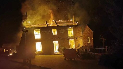
This is the first of two blog posts that set out a timeline of the destruction by fire and subsequent demolition of the Crooked House in Himley in early August 2023, through links to local and national press reports. This blog covers the period up to December 2023. Later reports can be found in the second blog post here.
In the days after the fire, there were many, very similar, press reports and thus there has been a need to be selective.  In what follows, I thus use three main sources.

  • BBC local and national news websites, which was, and continues to be, the most comprehensive source.
  • The Express and Star website, which gives a local perspective. Note that many of the articles that are linked require free registration to be read.
  • The Guardian website – although many national newspapers reported the story in early August, the Guardian’s was probably the most comprehensive and, through its columnists, the most reflective.

I also include articles from other sources where they complement the above, including a few from overseas to demonstrate the reach of the story.  I will update this list at intervals over the coming months.

In addition to the news links, there are two Facebook pages that contain news and (often robust) comments covering a range of opinion.

SAVE THE CROOKED HOUSE (LET’S GET IT RE-BUILT)

*Rebuild The Crooked House*

March to July 2023

10/3/23 BBC The Crooked House: Britain’s ‘wonkiest pub’ to be sold

28/3/23 BBC The Crooked House: Britain’s ‘wonkiest pub’ for sale for £675,000

28/7/23 Express and Star  ‘A great shame’ as Crooked House pub set to be redeveloped for ‘other use’

August 2023

6/8/23 BBC  The Crooked House: Fire rips through famed ‘wonky’ pub

6/8/23 Express and Star  Fire engulfs The Crooked House pub – flames and smoke seen pouring out of iconic building

6/8/23 Guardian Fire engulfs historic pub famed for being wonkiest in Britain

7/8/23 BBC ‘Questions need answering’ over Crooked House fire

7/8/23 Guardian Police ‘reviewing all evidence’ on cause of Crooked House pub fire

8/8/23 BBC Demolition of Crooked House pub unacceptable – council

8/8/23 Express and Star  Call to help protect pubs following Crooked House blaze

8/8/23 Guardian ‘It’s gobsmacking’: locals demand answers to demolition of Crooked House pub

8/8/23 Guardian West Midlands mayor calls for Crooked House pub to be rebuilt ‘brick by brick’

9/8/23 BBC The Crooked House pub fire and demolition controversy… in 52 seconds

9/8/23 BBC Crooked House: Fire at ‘wonkiest’ pub treated as arson

9/8/23 BBC Former Crooked House landlords appalled at fire and demolition

9/8/23 Express and Star  Detectives treating fire at Crooked House pub as arson

9/8/23 Express and Star  Calls to leave ‘no stone unturned’ in investigation into ‘wrongful’ demolition of The Crooked House

9/8/23 Express and Star  MP questions whether police knew about ‘wrongful’ demolition of Crooked House pub

9/8/23 Guardian The strange tale of The Crooked House tells a much bigger story

9/8/23 Guardian Staffordshire police treating fire at Crooked House pub as arson

9/8/23 Sidney Morning Herald British heritage pub destruction: Crooked House stood for 260 years. Now it’s a pile of rubble  

9/8/23 Construction News Crooked House demolition plant hire owner: “I’ve done nothing wrong”  

10/8/23 BBC Crooked House: Meeting over future of ‘wonkiest’ pub site

10/8/23 Express and Star  Poet Pam pens poem about the tragic demise of The Crooked House

10/8/23 Express and Star   Crooked House: How iconic pub helped people meet life partners, marry and enjoy life

10/8/23 Express and Star  Police confirm contact with Crooked House owners as arson probe at historic pub welcomed

10/8/23 Express and Star  Couple recall how Crooked House made wedding ‘best day’ – after initial venue burned down

10/8/23 Guardian Change planning laws to protect historic pub buildings, campaigners say

10/8/23 Daily Express Owners of ‘Britain’s wonkiest pub’ had history of gutting traditional pubs suggest claims

10/8/23 New York Times What Happened to Britain’s ‘Crooked House’ Pub?

11/8/23 BBC The Crooked House scandal ‘must be catalyst for change’

11/8/23 Express and Star  Crooked House: Advertising boss offers ‘handsome’ reward to whistleblowers

11/8/23 Express and Star   ‘A crime against the Black Country’: Crowds gather in anger at site of The Crooked House

11/8/23 Express and Star  The Crooked House listed application was being considered – body explains why new requests can’t be

11/8/23 Guardian Crooked House rebuild would be ‘very complicated and costly endeavour’

11/8/23 Guardian Other plans by Crooked House owners have caused anger in Midlands

12/8/23 Guardian ‘People are sick of having our heritage knocked down’: how the Crooked House saga became a state of the nation story

13/8/23 BBC The Crooked House: Mystery and anger surround wonky pub destruction

13/8/23 CNN The Crooked House was Britain’s wonkiest pub. Then it burned down

14/8/23 BBC Giddy the fire dog helping probe Crooked House arson attack

14/8/23 Express and Star  Crooked House: What we know about demolished building’s new owners

14/8/23 Guardian Yes, rebuild the Crooked House brick by brick – and buttress local planning, too

14/8/23 Constriction News  Crooked House demolition ‘does disservice to entire industry’

15/8/23 BBC Miniature Crooked House wins plaudits from across the globe

15/8 /23Express and Star  Remains of Crooked House pub fenced off as arson inquiry continues

15/8/23 Express and Star   The Crooked House: What we know about investigation into fire and demolition of famous pub

15/8/23 Express and Star  Wolverhampton man makes model replica of Crooked House for friend ‘gutted’ by blaze

15/8/23 Guardian The mystery of the Crooked House fire

16/8/23 Express and Star   Crooked House footpaths fenced off after police called to ‘activity’ at site

16/8/23 Express and Star  Rebuilding The Crooked House could take three years and cost millions, warns expert

16/8/23 Express and Star   MP urges public wanting answers about Crooked House pub to ‘be patient’

16/8/23 Guardian Crooked House owner linked to landfill that also went up in flames

17/8/23 Express and Star  Black Country real ale campaigners to step up pub protection after loss of The Crooked House

17/8/23 Express and Star   I want Crooked House to ‘rise from the ashes’ MP tells packed meeting

17/8/23 Guardian If only we’d had the vision to save the Crooked House

17/8/23 Washington Post Mystery surrounds burning of Crooked House, Britain’s ‘wonkiest’ pub

18/8/23 Daily Express Owners of The Crooked House pub jet off to Corfu as questions remain over demolition

19/8/23 Express and Star  Black Country artist completes striking painting of the night The Crooked House burned down

19/8/23 Irish Mirror Irish drug smuggler at centre of scandal over demolition of Britain’s ‘wonkiest pub’ – Irish Mirror Online Irish Mirror

21/8/23 BBC Crooked House: Protesters block road to destroyed landmark pub

21/8/23 BBC Crooked House: Glass engraver honours destroyed pub

21/8/23 Express and Star  Stand-off involving police and MP at site of The Crooked House after access blocked

22/8/23 Guardian Paranormal group keeps night’s watch on Crooked House pub site

23/8/23 Construction News Contractor claims to be salvaging Crooked House materials for reuse

24/8/23 BBC The campaigners working 24/7 to save the Crooked House                       

24/8/23 BBC Crooked House: Arson arrests in pub fire probe

24/8/23 Express and Star   Two arrested over Crooked House fire as West Midlands mayor again calls for pub to be rebuilt | Express & Star (expressandstar.com)

24/8/23 Guardian Two men arrested over fire at Crooked House pub in Himley

25/8/23 New York Times Two Arrested After Crooked House Pub Fire

25/8/23 Stuff (New Zealand) Two men arrested over suspected torching of ‘Britain’s wonkiest pub’

25/8/23 News.com (Australia) Two men arrested after fire at Crooked House pub

28/8/23 Express and Star  Crooked House campaigners renew pleas to rebuild ‘Britain’s wonkiest pub’ during live TV appearance on This Morning

30/8/23 Express and Star  CAMRA pushes for Asset of Community Value vote to protect remains of ‘vitally important’ Crooked House

31/8/23 Guardian ‘We’ve become one big family’: Camp Wonky continues watch of Crooked House site

September 2023

1/9/23 Express and Star  Contractors to move  off Crooked House site as ‘Ceremony of the Locks’ due to be held  

2/9/23 Express and Star  Crooked House campaigners explain round-the-clock vigil at site of demolished icon  

2/9/23 Express and Star  Thousands of bricks from The Crooked House are securely locked away in symbolic padlocking ceremony  

4/9/23 BBC Firm linked to Crooked House owner was taken to court

4/9/23 Independent Crooked House pub bricks locked away after being ‘sold for £50 on Facebook’   

4/9/23 Dudley News Man camps outside Crooked House pub to protect bricks  

5/9/23 Express and Star  Roofer who led work on Crooked House facelift describes heartbreak at seeing it demolished

6/9/23 BBC Derbyshire model maker creates miniature Crooked House pub

7/9/23 BBC Third arrest in Crooked House fire investigation

7/9/23 Express and Star   Third man arrested over suspected arson at Crooked House pub

7/9/23 Express and Star  MP Marco Longhi calls for parliamentary debate on fate of pubs like Crooked House

8/9/23 Express and Star  Third man arrested over suspected arson at Crooked House pub

9/9/23 BBC Can fire-hit Crooked House rise from the ashes?

10/9/23 Express and Star   Unofficial Crooked House camp left empty amid reports of clash at ruins of famous pub

11/9/23 BBC Probe as violence breaks out at Crooked House site

11/9/23 Express and Star  Woman hit by car and two assaulted at Crooked House site as police appeal for witnesses

14/9/23 BBC Man held after violence at Crooked House site

14/9/23 Express and Star  https://www.expressandstar.com/news/local-hubs/staffordshire/2023/09/14/west-bromwich-man-arrested-following-disorder-at-site-of-crooked-house-pub/

16/9/23 Express and Star  MP re-iterates support for Crooked House and support groups

21/9/23 Express and Star  Footpath near Crooked House site to be closed off for six months due to ‘concerns over the instability of the ground conditions’  

22/9/23 BBC Camra launch scheme to protect historic pubs

22/9/23 Birmingham Mail Crooked House saga prompts new way to save historic pubs in West Midlands  

28/9/2023  BBC  New arrests in Crooked House pub inquiry

28/9/2023 Guardian  Crooked House pub: police investigating fire arrest man and woman

28/09/2023 Express and Star Man and woman arrested in connection with suspected Crooked House arson

28/9/2023 Express and Star How to help Crooked House campaigners design new website and logo

October 2023

4/10/2023 BBC New arrest in Crooked House pub fire investigation

4/10/2023 Express and Star Sixth person arrested in connection with fire at Crooked House pub

5/10/2023 Express and Star Crooked House investigation praised as Staffordshire Police improves under ‘special measures’

5/10/2023 Express and Star Real ale campaigners meet MP over pub protection

27/10/2023 Express and Star Penny Mordaunt visits Crooked House site as Dudley North MP outlines priorities for heritage pubs

28/10/2023 BBC Model maker recreates Crooked House pub in miniature

November 2023

11/11/2023 BBC The leaning Christmas card honouring Crooked House pub

13/11/2023 BBC Crooked House Christmas cards and calendars sell out

18/11/2023 BBC MP calls for more to be done ‘to stop another Crooked House’

21/11/2023 Express and Star Crooked House glasses on sale at beer festival

22/11/2023 Mirror Crooked House owners ordered to stop demolition at another site ‘set to net them £10m’

29/11/2023 Guardian  Crooked House campaigners search for Black Country pub’s missing clock

30/11/2023 Express and Star  New video shows current state of Crooked House site as sections collapse

30/11/2023  Express and Star https://www.expressandstar.com/news/local-hubs/dudley/2023/11/30/crooked-house-is-rebuilt–in-childrens-book/

December 2023

24/12/2023 Stoke on Trent Live Meet the man spending Christmas Day defending the charred ruins of UK’s wonkiest pub

26/12/2023 Guardian Crooked House scandal highlights government inaction over pubs, says Camra

The early history of the Crooked House

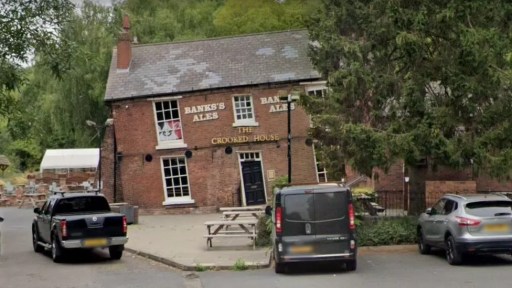
The recent burning down and demolition of the Crooked House public house in Himley in August 2023 has made news both nationally and internationally, and there are ongoing police investigations into the events and a vociferous campaign for rebuilding. In all the reporting, however, there has only been limited discussion of the history of the Glynne Arms, as it was formerly known. It is the intention of this post to fill in this gap, in terms of the early history of the property, up to around 1880. I feel this is important, as it gives something of the background and context that is perhaps somewhat lacking in the current conversations.

Figure 1 shows a modern Ordnance Survey map of the area. The Crooked House is indicated by a red circle on this figure and the ones that follow, which, unless otherwise stated, all show the same area to the same scale. The site of the Crooked House is situated on the north bank of the Himley Brook that flows east to west from the Old Park / Russell’s Hall area to the River Smestow, at the end of a mile long lane that leaves the Himley to Dudley Road just to the east of Askew Bridge (A). Footpaths from the site go north through Himley Wood (B), and south across an area of reclaimed industrial land (C) and the old GWR Kingswinford branch line (D) to Oak Lane (E), where there are various small-scale industrial businesses.  But the area that we see now is very different from how it would have looked a hundred years ago, which itself was very different from how it would have looked a hundred years before.

Figure 1. Location of the Crooked House on a modern Ordnance Survey map

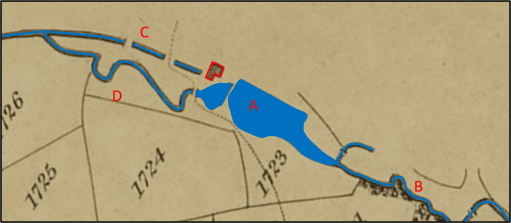
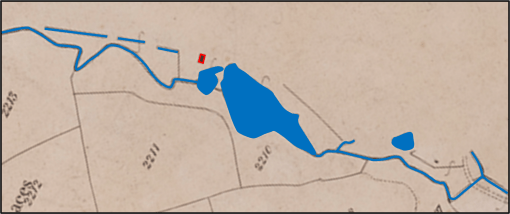
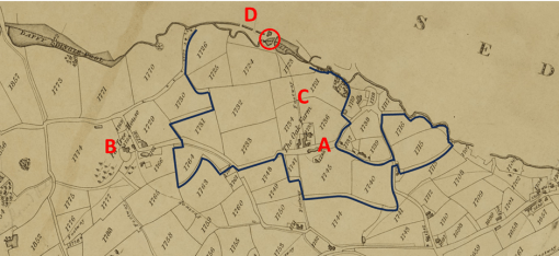
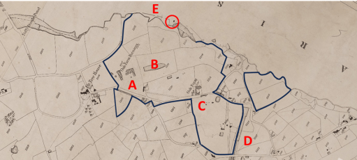
The Crooked House was built in 1765, probably as a corn mill, and first appears in the records on the 1822 Fowler map of Kingswinford parish (figure 2). The Himley Brook was the boundary between the parishes of Kingswinford and Himley, and the Crooked House, being to the north of the brook, was in Himley Parish, and thus its appearance on the Kingswinford map is quite fortuitous. At the time it was part of the Oak Farm Estate owned by Lady Mary Glynne of Hawarden in north Wales, that had been bequeathed to her and her husband by her father on her marriage to Rev Stephen Glynne in 1779 (Davies R (1983) “The Great Oak Farm smash”, Blackcountryman 16.3, 18). The estate consisted of around 90 acres of farming land mainly in the north of Kingswinford parish, with small areas in Himley and Sedgely parishes. The names of the fields give an indication of its rural character – for example Barn Close, Coppice Piece and Ox Ley.  The land to the north of the Crooked House was part of the Dudley Estate and was a mixture of arable and coppiced woodland. The figure shows the boundary of the estate, Oak Farm itself (A), Fir Tree House outside the estate owned by Lord Dudley (B) and the footway from Oak Farm to the Crooked House (C). At the time, the Oak Farm estate was largely farmed by Richard Westwood, who lived at the Oak Farm. The Crooked House was at this stage, clearly a mill, and the mill race can be seen on the map passing beneath the house (D). There would have been a waterwheel operated by the water from the pool on the Himley Brook to the east, with the water being returned to the brook along the mill race. The road network at that time was very different from the modern network, although Stallins Lane and its predecessor can be seen in the bottom right-hand corners of both figures 1 and 2.

Figure 2. The Crooked House on the 1822 Fowler map of Kingswinford Parish

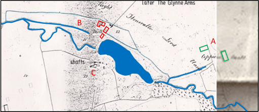
The next occurrence of the Crooked House in the historical record comes from the Tithe Apportionment records and maps in the early 1840s. The maps for Kingswinford and Himley parishes are shown in figures 3a and 3b. Note that the alignment to north is not quite consistent between the maps – the originals of both were aligned in somewhat arbitrary directions and alignment was not straightforward. In some ways the situation was very similar, with the surrounding countryside still very rural. But change was underway. The Oak Farm estate had passed to Lady Glyne’s son, Sir Stephen Glynne and in 1835 he and his partners had begun to exploit the large reserves of coal, ironstone and clay that had been found there.  In the tithe allocation the estate is said to be owned by the Oak Farm Colliery Company, with the owners of the company being Thomas Bagnall, James Boydell, Baronet Sir Stephen Glynn, John Hignett, William Hignett and Charles Townshend. Already there were the Oak Farm furnaces to the south of Himley Brook (A and B), together with at least three coal pits and three ironstone pits and the associated pumping engines (C). The northern end of the Stourbridge Extension Canal can be seen on Figure 3b (D). The boundary of the estate is also shown and, whilst it remains substantially the same as in 1822, there have been some changes in the region of the Extension Canal. The somewhat reduced area of arable land (57 acres) was farmed by several tenants, with the majority (50 acres) by John Cartwright who was based at the Crooked House. In the 1841 census, his age is given as 62 and he is described as a miller, farmer and beer shop keeper. He was living with his wife Sally, aged 56, and three domestic servants. The mill race can again be seen on both maps (E). Again, the road network can be seen to be different to the current network, with the current long lane to the Crooked House not appearing.

a) Himley Tithe map

b) Kingswinford Tithe map

Figure 3. The Crooked House on the Kingswinford tithe map and the Himley tithe map

The fate of the Oak Farm company is well documented elsewhere – there seems to have been a major lack of financial control, probably to an over rapid expansion by James Boydell, who was in charge of the management of the company, that led to a level of debt that could not be serviced. The firm went bankrupt in 1849, and all its very considerable effects were put up for sale. This included

…. that conveniently situated and commodious dwelling-house, now used as a Public-house, with the garden, stabling, outbuildings and appurtenances, and water corn mill, now in the occupation of Mr. John Cartwright……

The whole estate was eventually bought by the future prime minister William Gladstone, Stephen Glynne’s brother, Stephen Glynne himself and his brother Rev Henry Glynne. It took many years, and a great deal of money, for Gladstone to resolve the financial issues of the Oak Farm concern and the other Glynne Estates, but the Oak Farm works began to prosper. However, by the 1860s and 1870s the mineral resources in the Oak Farm area were beginning to fail, and on the death of Sir Stephen in 1874, the family finally sold the estate.

During this period, the Crooked House no doubt continued as a corn mill whilst there was any arable land left to produce grain, but also came to serve the coal miners and iron workers of the area. In the 1851 census, it is simply referred to as Himley Oak Farm Mill, run by Sally Cartwright, aged 66, John’s widow, who also farmed 30 acres (note the reduction from 1840). Her son Joseph (aged 26) was the miller. It is interesting to note that Sally sister, Fanny Amis, aged 74, also lived with them. In the Directory to the Fowler map of 1822 she is recorded as being responsible for the Hollies Farm in the Old Park / Russell’s Hall area.

By 1855, the Crooked House, now referred to as the Glynne Arms for the first time, was run by George Wilkinson, importer of foreign wines and spirits, and cigars. In the 1861 and 1871 censuses however, the pub was run by Joseph Woodcock, and his family.

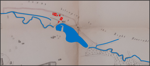
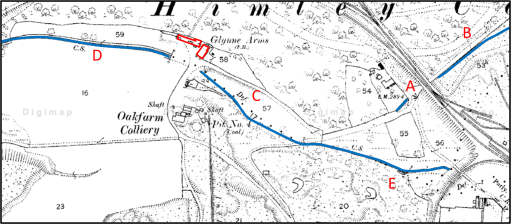
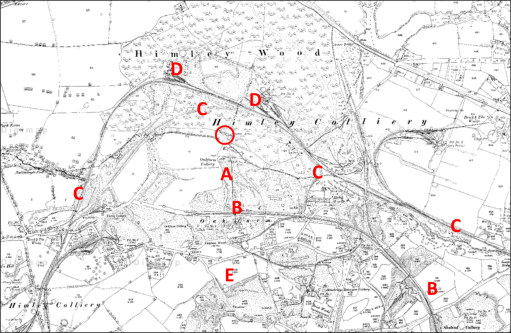
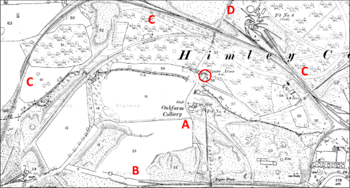
During the period of the Oak Farm concern rise and fall, the area around the Glynne Arms changed out of all recognition. Figure 4a shows the Ordnance Survey map of 1881 to the same scale as figures 1 to 3, whilst figure 4b shows the area around the Glynne Arms to a rather larger scale. The area to the south of Himley Brook had been extensively mined and the map shows the location of the Oak Farm Colliery and large areas of colliery waste (A). And the pub now seems to be surrounded by railway lines – the GWR Kingswinford branch to the south (B), at this time terminating in the Oak Farm area, and the complex tangle of lines of the Earl of Dudley’s Pensnett railway to the east, north and west (C). There are extensive railway sidings and collieries within Himley Wood itself (D). Very little undisturbed land remains. The mill pool has been drained, and the Himley Brook diverted, possibly along the mill race. A comparison of figures 1 and 4 does however show that the road network is approaching its final form and route of Oak Lane is very similar to the present and the long lane from the Himley Road to the Glynne Arms can also be seen, at least in part (E). The access still seems to be from the south however, showing that it was very much part of the Oak Farm estate.

(a)

(b)

Figure 4. The Crooked House on the 1881 Ordnance Survey map

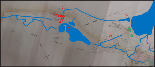
Figure 5 is taken from the Coal Authority web site and shows the mine entries that have been documented around the Crooked House. The cluster to the south of the Himley Brook (A) were part of the Oak Farm Collier and were in use from the 1860s to 1880s, and if mining subsidence caused the Crooked House to take on its iconic character before its destruction, the mines in this area are the cause.

Figure 5 Mine entries in the area of the Crooked House

In conclusion then, it is clear that the early history of the Glynne Arms / Crooked House was bound up with the development and tribulations of the Oak Farm Estate, and there was a gradual transition from its role as a Corn Mill to that of a Public House. It may be that, should the remaining foundations of the Crooked House ever be investigated as part of any rebuilding that some interesting archaeological remains might be found, pertaining to the corn mill (perhaps the wheel pit or supports, and remains of the mill race).

The fields that survived

Preamble

The area known as the Black Country was of course originally rural in character and consisted of fields and woodlands with scattered settlements. However, in the area that lay on the Staffordshire coal field there was ultimately very little land that was left untouched by the direct activities of coal mining and its associated larger areas of spoil, or by the industries that relied on the coal. Coupled with the massive housing developments of recent years, nearly all the rural land in the mining areas of the conurbation has long since disappeared. This is illustrated in the Ordnance Survey Map for the Kingswinford / Pensnett area at the western edge of the Black Country in Figure 1, where there is very little open space to be seen, and what there is, is almost always “made ground” – landscaped former waste and industrial areas.

In this post however I want to draw attention to one small area of land that seems to have escaped the ravages of mining and industry and sustained its agricultural / green space nature into the present. This is contained within the black rectangle of Figure 1 – the are on which currently the Pens Meadow School sits, along with its associated playing fields. We will illustrate this through the use of maps from 1822 to the current day, and on the way draw out some other interesting aspects of this very small area of the Black Country – a sort of micro-history of a very limited area.

Figure 1. The Kingswinford / Pensnett area 2023

The 1822 and 1840 Fowler Maps

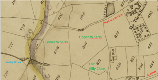
Figure 2. The 1822 Fowler Map

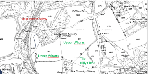
We begin with a map from 1822 in Figure 2 – an extract from the map of Kingswinford parish produced by the firm of William Fowler about which I have written elsewhere. The location of this extract with regard to the wider area is shown by the black rectangle in Figure 1. It basically shows the area to the west of Tiled House Lane and Bromley, both of which are indicated in red. In what follows we will concentrate on the three fields with names shown in green –Upper Wharrs (almost 9 acres); Lower Wharrs (6 acres) and The Hilly Close (3 acres). These were all part of the Tiled House Estate which ran from Commonside to the east, down the south side of Tiled House Lane and extended westward as far as the Standhills area, and southwards as far as Bromley Lane. See here for more information on this Estate. At the time it was owned by the Trustees of the Late Richard Mee, and was suffering from severe financial difficulties. The Wharrs were rented out to Thomas Brettell for farming, and the Hilly Close to James Mullet for similar purposes. Whist the name of The Hilly Close is self-explanatory (it was actually on a region of slightly higher ground than the surroundings), the name of Wharrs is not familiar to modern ears. It’s meaning is something like “land where willows grow” – and thus could be expected to be somewhat damp. The reason for this can be seen in the bottom left of the figure – the Dawley Brook forms in the bottom of the Lower Wharrs. This drains out to the north beneath the Dudley to Kingswinford Road, through what is now Kingswinford Park and out westwards to the River Smestow. Whilst the map is from 1822, in all likelihood these three fields existed within the 1822 boundaries for several centuries before that. It is certainly the fact that the field boundaries in the Corbyn’s Hall estate to the north were unchanged from 1680 (and probably long before) to 1822.

In what follows, I will try to show in what follows that two of these three named fields – Upper Wharrs and The Hilly Close managed to escape the fate of nearly all the fields in the area of being ravaged by mining and the associated spoil heaps, and the later residential development.

On the map of Figure 2, two other features of interest stand out – The Tiled House itself to the east, the site of late 17th century steel making experiments, and the coloured lines to the west. The latter show the course of the Stourbridge Extension Canal that was built in 1837 and did not exist in 1822. At some point in the map’s history (probably before 1837) someone added these lines to the 1822 map, for the purposes of confusing anyone who should try to read it in the 21st century.

Figure 3. The Fowler Map of 1840 – the Tithe map

Figure 3 shows an extract of the same area from the 1840 Tithe Map of the area, again produced by the firm of William Fowler for the pruposes of allocating tithe rentals. The Stourbridge Extension Canal is shown on the left, with the Standhills branch going off the west. There is also a tramway marked that took the products of the Corbyn’s Hall estate to the canal basin at wide waters. It was built in the late 1820s, but in 1837 was purchased by the canal company and decommissioned. It would have been operated by gravity, as there is a considerable slope from north to south, passing beneath the road at Bromley, presumably with horses used to pull the empty wagons back up the slope. Unfortunately, little other information is available about the tramway – for example the nature of its construction, its gauge, truck size and capacity etc.

But despite these developments, the three field under consideration were not affected. They were still owned by the Mee trustees, and all let out to one Walter Dudley. Lower Wharrs was described as pasture with a tithe rental of 3s 4d, Upper Wharrs as meadow with a rental of 6s, and the Hilly Close as Arable land with a rental of £1 – showing the higher value of arable land in comparison to pasture and meadow.

The 1880 and 1900 Ordnance Survey maps

Figure 4. The  Ordnance Survey map from the 1880s

By the time of the first large scale Ordnance Survey map in the 1880s (figure 4) the situation had changed significantly, with industrial activities encroaching on the area. The Great Western Railway Kingswinford branch runs to from south to north to the east of the canal. There are disused mines that encroach on the area of the Lower Wharrs (Tiled House Colliery Pits 17 and 18) and to the south of the Tiled House (Tiled House Colliery Pits 19 and 20) with the New Bromley Colliery still operating to the south of Upper Wharrs and Hilly Close. Both of these fields however retain their former boundaries and were still used for farming. Tiled House Lane takes on its modern shape of an east to west portion down from Commonside, although extended further west that it does currently, and a north south portion to the east of Upper Wharrs toward Bromley, although both parts carry the name of Rookery Lane at this time. Indeed, the top half of the north-south portion follows the line of the old Corbyn’s Hall tramway, the extension of which towards Bromley is still visible on the map.

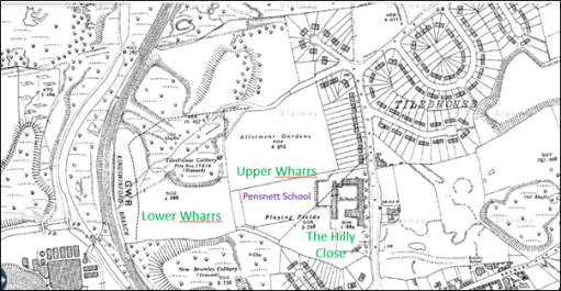
In the Ordnance Survey map from the 1900s of Figure 5 the situation is similar, although the name of Tiled House Lane is attached to its east to west portion and Rookery Lane to its north to south portion. The southern part of the Lower Wharrs and the other two fields still retain their earlier boundaries. 

Figure 5. The Ordnance Survey map from the 1900s

The 1930s and 1960s Ordnance Survey maps

Figure 6. The Ordnance Survey map from the 1930s

Figure 6 shows an Ordnance Survey Map from the 1930s, and there have been significant changes. The Tiled House itself has disappeared, and the Tiled House housing estate in now in existence in its current form. The Pensnett Secondary Modern School has been built, mainly on the Hilly Close, with the southern half of Upper Wharrs as the playing field and the northern half as allotments (behind the houses on Tiled House Lane). The Lane itself has been somewhat straightened out in the process of this development. Nonetheless the combined area of Upper Wharrs and The Hilly Close has retained its integrity and to some degree its agricultural function. The northern half of Lower Wharrs and the area to the south still seems to consist of colliery waste.

One other interesting point to note is that the boundary of the Corbyn’s Hall tramway is marked by the line of the back gardens in the southern cul-de-sac on Tiled House Lane. An archaeological dig in the back gardens of numbers 124 to 130 might well reveal something about the nature of the tramway, but would probably not be much appreciated by the residents. Similarly, the point where the tramway passed underneath Bromley (just outside the current Pensnett / Bromley school entrance) could well retain some evidence of the tramway.

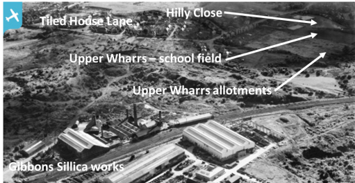
The same situation is illustrated in the aerial view from 1950 shown in figure 7. The view is centred on the Gibbons works on Corbyn’s Hall, but to the top of the picture the outlines of Upper Wharrs and The Hilly Close can be made out, together with both legs of Tiled House Lane.

Figure 7 Aerial view from 1950 (from Britain from Above)

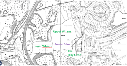
The situation is very similar in the 1960s map of figure 8, although the area of the allotments has become a playing field area.

Figure 8. The Ordnance Survey map from the 1960s

The present-day situation

Figure 9. The 2023 Ordnance Survey map

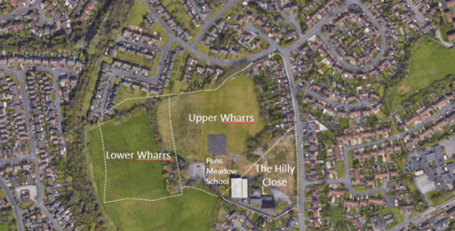
Finally, we come to the present-day situation shown in the up-to-date Ordnance Survey map of Figure 9 and the Google areal view of Figure 10. The school has been replaced by a new entity -the Pens Meadow School in The Hilly Close, and the area of the Upper Wharrs is now playing field or car parks. The eastern portion of Lower Wharrs has been incorporated into the field. The waste area in the north of Lower Wharrs has either been developed for housing or been landscaped as a recreational area. The waste area to the south has been treated in the same way, to give a large green space alongside the railway line.

Figure 10. An aerial view of the current situation (from Google maps)

It can thus be seen from these maps it can be seen that the area of Upper Wharrs and the Hilly Close represents a remarkable survival of a “land unit” that, in the main escaped the ravages of mining and waste and has retained, to a large degree, its “green” character. It also suggests that the name of the school currently on the site should either be “Hilly Close school” or perhaps even the “Wharrs school”. I doubt the second would be much appreciated by parents, teachers or children.

A memory of Dudley Sports Centre

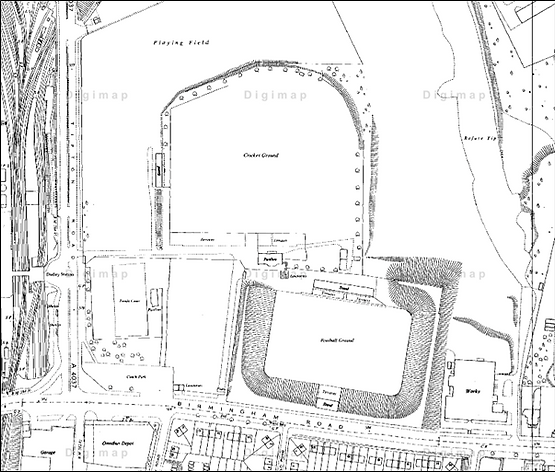
Dudley Sports Centre was a large football and cricket ground of the Tipton Road in Dudley. I guess these days it would be called a multi-sports complex! A 1950s map is shown below. The football ground was to the south with the main stand backing onto the cricket ground, with the cricket ground to the north, with the Pavilion and terraces in front of the back of the football stands. There were playing fields to the north and the west. It dated from the 1880 but was much expanded in the 1930s when the football ground was opened. It was used by Dudley Cricket Club and Dudley Town FC. Over 16000 spectators attended Dudley Town’s first match in 1932. Worcestershire CCC used it as an out ground from 1911 to 1977 for first class and list A fixtures.

The Sports Centre in the 1950s

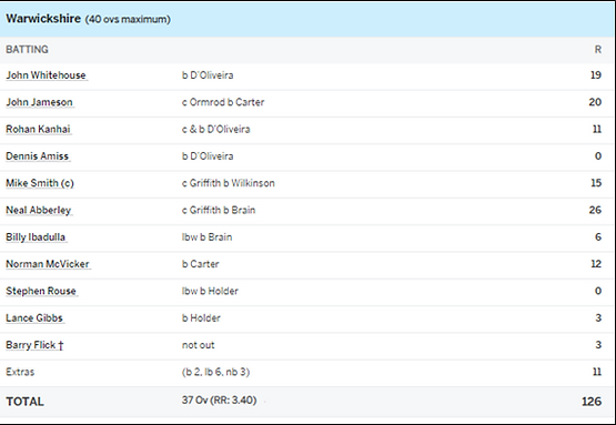
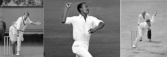
As a teenager, I watched games at the ground on many occasions – football matches between Dudley Town and my team, Brierley Hill Alliance, and a variety of other games including county cup finals; and cricket games when Worcestershire were in town. It is one of the latter that sticks most in my memory. This was the game between Worcestershire and Warwickshire on 5th September 1971, when I was 17. This was a 40 over John Player league game (in the days when it was felt acceptable for manufacturers of carcinogenic products to sponsor sports competitions). Worcestershire had had a good season and in this, their last game of the season, needed to win the match to have any chance of winning the league. As ever with cricket, the situation was complicated, and not only did they need the four points from the win, they needed to ensure that their run rate (runs / over) over the season was such that it surpassed that of Essex, the team below them. Even then they could not be sure of the title, as the third placed team, Lancashire had a game in hand, and played the following week. Lancashire had to lose that game, even if Worcestershire won on September 5th. I remember sitting on the terraces to the west of the Pavilion shown on the above figure. The TV cameras were in attendance, and my mother spent the entire afternoon watching a cricket match on BBC3 to see if she could see me in the crowd. Warwickshire batted first, and their scorecard is below. The only managed to make 126 – a very low score even in those pre-T20 days. Of the bowlers, Basil D’Oliveira, Vanburn Holder, the overseas signing for the year, and Brian Brain did most of the damage.

The Warwickshire Innings

Basil D’Oliveira, Vanburn Holder and Brian Brain

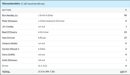
In the Innings break it was announced that, in order to achieve the required overall run rate for the season, Worcestershire needed to surpass that total in 17.5 overs – so the match became a T20 match 30 years before that concept was invented. I remember little of the innings other than its frantic nature. The scorecard is again given below. Nearly all of the runs were scored by three players – Ron Headley, the son on the West Indian batsman George, Basil D’Oliveira again and Alan Ormrod. Worcestershire made the required total with two balls to spare, resulting in raucous celebrations. Lancashire obligingly lost the match the following week, and Worcester were proclaimed as champions.

The Worcestershire Innings

Ron Headley, Basil D’Oliveira and Alan Ormrod

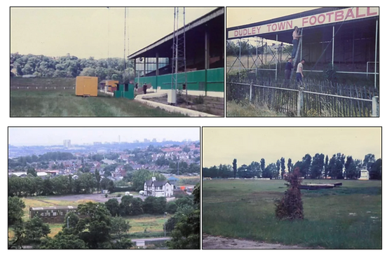
I went off to university a year after the match, and I don’t remember seeing any more cricket there. As is well known, the Sports Centre was shut in 1985 after a large hole appeared and part of the pitch disappeared into a limestone cavern beneath the site. Worcestershire never played there again, and Dudley CC, a long-term member of the Birmingham League, folded. Dudley Town have led a peripatetic existence ever since, playing at a number of grounds within and without the borough – the Round Oak stadium, the Dell stadium, Tividale and (currently) at Willenhall. The site is now the home of the Castle Gate complex.

The Sports Centre after closure

An election manifesto for Transport

Introduction

As the journalist Christian Wolmar has discussed in a recent article, the UK does not have any sort of agreed National Transport Policy that could be used as a rational way of developing transport infrastructure in a politically non-partisan way. Such a policy will certainly not emerge from the current government, and there is little to suppose that any future government will give priority to developing such a plan. Without it, transport policy is vulnerable to ill thought-out ad hoc initiatives and, as at present, in ad hoc cutbacks. In this post I will suggest a pragmatic way forward on this.

What I propose is based on the assumption that the next Government will be formed by the Labour Party, either as a majority party or with some sort of agreement with the Liberal Democrats. This is certainly what would be suggested by the opinion polls where at the time of writing Labour have a 22% lead over the conservatives. The Labour party has proposed five “missions” that will direct their approach to the 2024 elections and any subsequent government. None of these missions mentions transport at all, but there are transport issues embedded in each one of them. In what follows, I set out these missions, the transport issues that arise from them, potential policy objectives, and potential policy proposals. I then bring these proposals together to form a list of Transport policies that could be used, no doubt in a modified format, both for the next election and in any subsequent government.

Readers should not assume from this that I am a Labour Party supporter. I have never been a member of a political party, and never intend to be. Politically I am a centrist, but with somewhat radical environmental views, formed partly by my professional work as a Professor of Environmental Fluid Mechanics at the University of Birmingham (now retired). The proposals below are simply pragmatic – a possible way of influencing the next government to do something sensible in transport terms.

The Labour Part Missions

Mission 1

Secure the highest sustained growth in the G7, with good jobs and productivity growth in every part of the country making everyone, not just a few, better off.

Transport issues

  • Transport congestion on road and rail, for both people and products, leading to reduced productivity.
  • Poor workforce mobility, leading to inflexibility in employment locations.
  • DfT methodology for assessing CBR of transport infrastructure does not take proper account of induced flows on highways – i.e. new roads encourage traffic growth and can increase congestion.

Transport policy objectives

  • Revise DfT methodology for assessment of congestion reduction of new roads to include induced flow effects.
  • Infrastructure interventions to reduce road and rail congestion.
  • Encouragement of modal shift from road to rail, for both people and products.

Transport policy proposals

  • Revision of DfT methodology for assessing congestion reduction of new road schemes to include proper consideration of induced flow.
  • Small number of specific congestion-reducing road schemes (consistent with Mission 2).
  • Speed up development of rail enhancements and new build (HS2, EWR and NPR).

Mission 2

Make Britain a clean energy superpower to create jobs, cut bills and boost energy security with zero-carbon electricity by 2030, accelerating to net zero.

Transport issues

  • DfT methodology for assessment of contribution new transport schemes to carbon production and climate change has been shown to be flawed, particularly in relation to new roads.
  • UK Carbon based transport emissions levelling off or increasing.
  • Transport is now major carbon producing sector of economy.

Transport policy objectives

  • Reassessment of DfT methodology for assessing environmental impact and carbon production of new transport schemes.
  • Development and roll out low carbon technologies (electric and hydrogen vehicles, electric trains) including electric car recharging infrastructure.
  • Encouragement to use low carbon modes of transport and active travel modes.

Transport policy proposals

  • Revision of DfT methodology for assessing environmental impact of new road schemes to be revised.
  • Investment in electric and hydrogen vehicle research and production
  • Development of electric vehicle recharging infrastructure.
  • Electrification programme for railways
  • Fiscal incentives to encourage low carbon mode use.

Mission 3

Build an NHS fit for the future by reforming health and care services to speed up treatment, harnessing life sciences and technology to reduce preventable illness, and cutting health inequalities.

Transport issues

Transport policy objectives

  • Improve urban air quality through encouraging low emission vehicles.
  • Improve air quality through traffic reduction and modal shift to public transport.
  • Encourage active travel (cycling and walking).
  • Improve public transport (primarily bus) links to health care facilities,

Transport policy proposals

  • Fiscal incentives for ULEZs and LTNs.
  • Support for public transport
  • Fiscal incentives to local authorities to provide active travel infrastructure.

Mission 4

Make Britain’s streets safe by reforming the police and justice system, to prevent crime, tackle violence against women, and stop criminals getting away without punishment.

Transport issues

  • Safety issues due to high road speeds in urban areas.
  • Safety issues due to pavement parking.

Transport policy objectives

  • Make urban streets safe for pedestrians and cyclists.

Transport policy proposals

  • Fiscal incentives for LTNs.
  • Lower and enforce urban speed limits.
  • Enforce pavement parking laws.

Mission 5

Break down the barriers to opportunity at every stage, for every child, by reforming the childcare and education systems, raising standards everywhere, and preparing young people for work and life.

Transport issues

  • Poor access to childcare and education for those without cars (20% of households)

Transport policy objectives

  • Improve access to childcare and education for those without cars.

Transport policy proposals

  • Support for public transport
  • Fiscal incentives to local authorities to provide active travel infrastructure.

The policies

From the consideration of the individual missions, the following specific transport policies can be developed.

Policy 1

Revision of DfT methodologies for assessing new transport schemes to take proper account on induced flow and environmental effects. (Missions 1 and 2)

Policy 2

Invest in new transport infrastructure with a small number of congestion-relieving road schemes, electric car charging facilities, and major investment to rail infrastructure, including staged development of HS2, NPR and EWR) and a rolling programme of electrification. (Missions 1 and 2)

Policy 3

Support for public transport (trains and buses) for increasing employment opportunities and providing access to healthcare and education. (Missions 1, 3 and 5)

Policy 4

Reduction of urban speed limits and enforcement of pavement parking laws. (Mission 4)

Policy 5

Fiscal incentives and support to local authorities to encourage low carbon vehicles and modal transfer to low carbon modes; for the development of ULEZs and LTNs, and provision of active travel infrastructure. (Missions 2, 3 and 5)

Commentary

Policy 1 is not going to set any electoral debate alight, but it is quite crucial. In the past the DfT has used flawed policies to assess road building schemes against other transport schemes, knowing that they were flawed. This needs to change. Indeed, I would regard the DfT as no longer fit for purpose in many ways (as an example, its current handling of the railway network, the ongoing industrial action and major cutbacks to active travel budgets can be cited) and there is an argument for a complete re-organisation here to establish a wide ranging Department for Infrastructure that brings together transport, the utilities and construction. This would allow proper consideration to be given to the transport effects of new housing build (often built without public transport provision) and conversely the effect of a move to electric vehicles on the development of the electricity grid.

Policy 2 is wide ranging and expensive, and any specific proposals would need to be carefully phased in terms of expenditure. The basic point however is that high quality transport infrastructure for people and products is a fundamental requirement for a productive economy, the more so as the switch to the “green economy” proceeds.

Policy 3 is important for many, and in particular those on low incomes. The provision of a high-quality public transport network (particularly buses) that is comprehensive in its coverage would make access to employment, healthcare and education very much easier for many people.

Policy 4 is essentially aimed at public safety. It would no doubt be categorised as a “war on motorists” by sections of the press, but this is a battle that needs to be fought for the public good.

Policy 5 is another proposal that might be electorally contentious as (weirdly to my mind) LTNs, ULEZs and active travel have become very politicised. Fiscal incentives could be a way forward here, as proposed in the more detailed description of Mission 2 recently released by the Labour Party. This might include the possibility of both support for the initiatives and a wider reduction in rates for those Local Authorities that develop such schemes. This would be basically a bribe, and would need to be carefully costed and targeted, but could help in the establishment of such schemes. In terms of encouragement to use low carbon modes, a study should be initiated to look at how road pricing, aviation fuel duty and rail fares could be used to encourage the necessary modal shift.

The 292 bus route from Kidderminster to Ludlow – an important transport link?

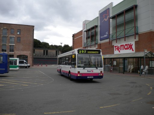
292 at Kidderminster Bus Station in 2010

I have recently been on a short break to Cleobury Mortimer in Shropshire, travelling there by train and bus from where I live in Lichfield. The train journeys, from Lichfield to Birmingham and Birmingham to Kidderminster went very smoothly and were quite a pleasant experience. There were a number of route permutations, but we chose to walk between Birmingham New Street and Birmingham Moor Street, both on the way there and back. The bus leg from Kidderminster, on the Diamon bus 292 was rather less easy. The bus didn’t stop at Kidderminster railway station, with the nearest advertised stops (on Google and various websites) being 400m away in Oxford St. Arriving there however, we found this was not the case, with no mention of the 292 on the timetables at the stop, so we walked on to the bus station, another 400 yards away. There we eventually did get the bus, which was running over half an hour late. The journey itself was fine, and as we were in no hurry, the delay was of no particular concern to us.

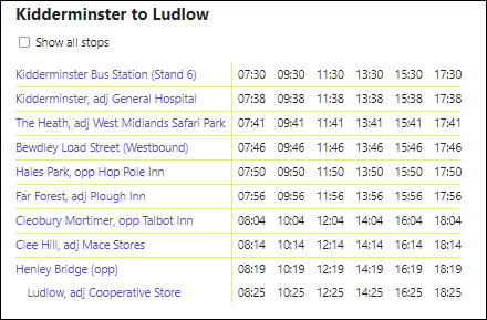
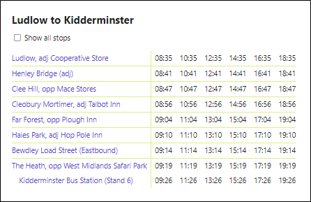
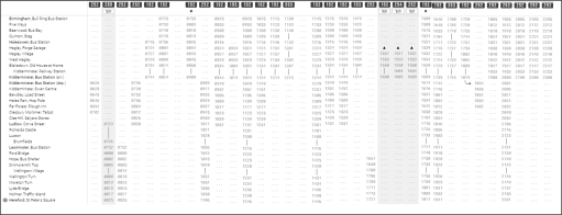
Over the days that followed, I kept track of the buses on the 292 route between Kidderminster, Bewdley, Cleobury Mortimer and Ludlow, and it soon became clear that the lateness was endemic. The journey was timetabled for 50 to 55 minutes, with a two-hour frequency, with one bus shuttling backwards and forwards – see the timetable below – from https://bustimes.org/services/292-kidderminster-ludlow . This timing was simply too tight to ensure punctual running throughout the day. Whilst some of the delays came from congestion in the towns at either end of the route as might be expected, the most critical delays were due to parked cars on the A4117 between Bewdley and Ludlow requiring single file traffic through the towns and villages along the road. Such delays could of course be quite easily eliminated, given the political will.

Current 292 Timetable

Now service 292, currently operated by Diamond buses, is actually the truncated remains of a much longer Midland Red service with the same number, that ran from Birmingham to Kidderminster, Ludlow and Hereford. A time table for this service is shown below from 1991 for the Birmingham – Hereford direction – from http://midlandred.net/service/timetable/display.php?routeID=1007. The service was withdrawn, apart from the Kidderminster to Ludlow leg, in the early years of the current century. It can be seen at that time there was an hourly service between these two towns, rather than the current two hourly service. This represents a considerable degradation in service provision.

292 Timetable 1991

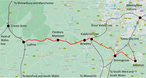
But the transport context has changed in many ways over the last few decades. The role of the long-distance bus has been largely taken over by trains, with a much greater frequency than 30 years ago. On the original 292 route there are now 4 trains an hour to Kidderminster from Stratford upon Avon through Birmingham, either terminating there or continuing to Worcester, and two from Worcester to Birmingham; at Ludlow there are two trains per hour in each direction between Manchester, Shrewsbury, Hereford and various destinations in south Wales. So in this sense, the truncation of the service was sensible and appropriate.  It now serves a purely local market for those who live on its route.  But I would argue, in any sane country that takes seriously the need to reduce carbon emissions and the need for modal change (i.e. not the one in which I reside), the Kidderminster to Ludlow route would be of some strategic importance. With improvements in frequency and connections with rail at Kidderminster and Ludlow, it would offer a route from the West Midlands conurbation, via  the Stour Valley line, into south Shropshire and the Marches, with major tourist potential. Further, if the route were combined with the hourly 52 from Kidderminster to Bromsgrove (and ultimately Redditch), it would offer connections from the south west at Bromsgrove into the same area, and also from the Cross City line that serves the north of Birmingham and the city centre. The 52 actually runs past both Bromsgrove and Kidderminster stations. Continuation of the service north of Ludlow to Craven Arms (in parallel with the railway) would offer connections to the Heart of Wales line, whose tourist potential has not been fully developed, and perhaps further to Welshpool for connections to the Cambrian line. All these possible connections are shown in the figure below.

But life is of course not that simple. For such a service to be a success other changes would be necessary. Firstly, efforts would be required to split the local markets in Ludlow and Kidderminster from the longer-distance markets to make overall journey times on through services as short as possible. There is no reason why this should not be possible but would require extra resources in terms of service provision to meet the requirements of the very local market. This mix of markets has been a major reason for the demise of long distance inter-urban buses in the past – perhaps most recently in the truncation of the Oxford to Cambridge X5 at Bedford, because the local market between Bedford and Cambridge resulted in significantly increased journey times.  Secondly, attention would need to be paid to the interchange points at either end of the route. For example, the bus stops of the Bromssgrove to Kidderminster route at Kidderminster Railway Station are on narrow pavements on a road bridge over the railway line – a very uninviting and inconvenient place for mode transfer. Attention would also o fcourse need to be paid to timetabling to ensure suitable connection times.

The other issue is of course more structural in that there is no overall transport policy in the UK that would facilitate such developments – see the recent blog by Christian Wolmar on this. And this lack of an overall policy means that resources cannot be channeled to such schemes, despite the fact that their benefits would be significant in terms of carbon emission reductions and stimulating local economies. It has always been thus as far as I can remember. I still want to believe that a competent government will one day realise that this is the road to take. But perhaps I am here opening myself up to a charge of naivety.

Migration to the western Black Country, 1800 to 1850

Industrialisation came rather late in the day in the parish of Kingswinford on the western edge of the Black Country (Figure 1). Although there was, in the eighteenth century, a long-established glass industry around the village of Wordsley in the south of the parish, and some shallow coal mining and iron manufacture around Brockmoor and Brierly Hill in the south east, it wasn’t until the first half of the nineteenth century that these grew in scale and spread northwards across the Staffordshire coal fields to utterly change the character of what was a largely rural area around Kingswinford and Pensnett (Figure 2). I have written on this process elsewhere – see here – in particular, in the context of the two Fowler maps of the parish that were produced in 1822 and 1840, which between them graphically illustrate this process of industrialisation.

Figure 1. Location of Kingswinford parish

Figure 2 Ecclesiastical Districts within the parish

These developments inevitably led to a major increase in the population of the parish, through migration from surrounding areas and further afield. The census population figures are given in Figure 3, and the growth is population is very apparent. It is the purpose of this short post to investigate where this increase in population came from. I use the data from the 1851 census that has been transcribed into digital form by Ancestry, for all 27,413 entries for the parish, which I copied and pasted page by page from the census returns into an EXCEL spreadsheet in order to carry out the analysis – a lengthy, mind-numbing process and not to be recommended.  This included name, area of residence, age and place of birth. This enabled all the entries to be sorted as follows.

Figure3 Population of Kingswinford parish 1801 to 1851

  • By age, and then grouped into 10 and 20 year age bands.
  • By residence, in one of the five “Ecclesiastical districts” within the parish that were set up as a precursor to these areas becoming parished in their own right later in the 1850s. Each of these corresponded to a number on census enumeration districts. These were in the old established industrial areas of Wordsley, Brockmoor and Brierly Hill, where there was significant industry in the late eighteenth century; in the areas industrialised between 1820 and 1840 to the north of the parish of Kingswinford village itself (which still retained large rural hinterland) and in the Pensnett area; and in Quarry Bank in the south east, where industrialisation took place in the decade before the census (Figure 2). Residents of the Workhouse in Wordsley was not included in the analysis.
  • By birthplace, defined as being within one of five regions – Kingswinford parish itself; the Black Country and Birmingham (the former as defined largely by the modern four Black Country boroughs); Staffordshire (excluding the Black Country regions); Worcestershire (excluding the Black Country regions); Shropshire (excluding the detached portion of Halesowen which was taken as part of the Black Country); and elsewhere – mainly locations in England and Wales, with a very small number from Ireland and Europe). Around 1% of the total population were not allocated a birthplace in the Ancestry transcripts, due to non-legibility of the written entries.

The most populous of the Ecclesiastical districts was that of Brierly Hill with 8800 inhabitants, followed by Pensnett with 4947. The others had populations of around 3000 to 4000 .  The breakdown by age decades for the entire parish population is shown in Figure 4, as percentages of the population of each Ecclesiastical district. All areas show similar trends, with around 50% of the population below the age of 20 (which was partly driven by the very large infant mortality). Figure 5 shows the birth locations for the parish as a whole, this time in 20 year (generational) age bands. The majority of the 0 to 19 year band were born within the parish or the surrounding Black Country (85%), but the situation is very different for the other generational bands, with only around 55% of the total being born in Kingswinford parish or the Black Country, with significant numbers being born in the three surrounding counties, particularly Shropshire, and around 10% of the total coming from further afield. This indicates that there had been significant migration, around 20 to 50 years before the census, which is consistent with the overall population growth shown in Figure 3.

Figure 4. Age breakdown of parish population

Figure 5. Breakdown of population by age and birthplace

This pattern varied somewhat across the parish, and similar results for each Ecclesiastical district are shown in Figure 6 for the old established industrial regions of Brierley Hill, Wordsley and Brockmoor; for the regions industrialised in the previous 50 years in Kingswinford and Pensnett; and for the Quarry Bank area industrialised over the previous decade. The figures for Brierley Hill, Brockmoor and Wordsley show slightly higher proportions of “local” Kingswinford and Black Country births for the older generations than the parish overall i.e. lower levels of migration. The figures for Kingswinford and Pensnett are very different, with local births for the adult generations below 50%, and only around 30% for the parish births. The proportion of Shropshire births, particularly in the Pensnett data is very large, of the order of 25 to 30%, mainly, as far as can be ascertained form the records, from the Shifnal / Oakengates area. In the newly industrialised Quarry Bank area the pattern is different again with 60 to 70% of local births and the main contributor to the rest coming from Worcestershire (and in particular those areas of the county close to the Black Country).

Figure 6. Breakdown of population for each Ecclesiastical district

The levels of migration from Shropshire into the Pensnett / Kingswinford area are of particular interest. It is to my mind likely that such levels would result in significant social tensions, and there is also some evidence of “ghettoisation” (if such a word exists). For example, there was a road in Kingswinford that was named “Shropshire Row” and the Shut End Primitive Methodist church seems to have chiefly served the migrant Shropshire population. This can be illustrated by a spatial analysis of the Pensnett census entries. The occurrence of a Shropshire birth entry was plotted against census entry number for the Pensnett enumeration districts (Figure 7). There can be seen to be regions on the graph that show high density of Shropshire births (around entry 3400, and entries 4000 to 4900). Cross checking against addresses from the census shows that these regions correspond to the new housing estates in the Hollies area, along the Turnpike Road towards Dudley. In these areas the percentage of those with Shropshire births is over 30%. Whilst this analysis is somewhat subjective, it does tend to suggest that a degree of concentration of the Shropshire migrant population did take place.

Figure 7. Shropshire births in the Pensnett census entries (vertical line shows register ntry with Shropshire birthplace)

There is one particular migrant group that, though small in number, might well have been quite conspicuous due to language and accent – the Irish. In the 1851 census returns there are 131 entries which register a birth in Ireland. These were mainly concentrated in Brierly Hill (69), Wordsley (35) and Brockmoor (20), i.e. the older industrialised areas, with very few in the Kingswinford, Pensnett and Quarry Bank areas. Of these 36 were under 20, 62 between 20 and 39, 30 between 40 and 59 and only 3 over 60, suggesting perhaps a more recent migration than other groups, mainly over the previous 20 years.

Now the analysis of both the wider parish population and those born in Ireland has not taken into account the Workhouse population, since this was the Poor Law provision for the entire Stourbridge Union, which was larger than the parish. However, in 1851 there were 260 Workhouse entries, 0.95% of the total parish population. 17 of those registered a birthplace in Ireland, 11.5% of the total Irish population – in other words those born in Ireland were significantly over-represented in the Workhouse population.

Finally it is worth noting that much more could be done – particularly in investigating the nature of migrant employment. However there is an issue here in that the census employment details have not been transcribed into digital form, and would need to be transcribed by hand from the original forms (some 30 or 40% of the total number of register entries). This would be an even more time consuming and mind numbing occupation than the one undertaken to date to get the data on which this blog is based. Maybe I will get round to this when I want for something to do. Then again, maybe I won’t.

Yet more on cross winds effects on trains

Train blown over by high winds in Switzerland in March 2023

This post and its attachments continues a sporadic (and what some might call obsessional) series on the effects of cross winds on trains. It gives links to a downloadable report and a downloadable spreadsheet.

The report (below), which follows on from two papers I wrote in 2010 and 2013, presents a detailed analysis of the effects of unsteady crosswinds on trains using a simple train dynamic system methodology. This begins with the specification of unsteady wind characteristics that are then used to calculate unsteady aerodynamic forces. These are then used as input to the dynamic model to calculate lateral, vertical and rotational displacements and unsteady track forces. Three specific effects are then considered – wheel unloading criteria, track force criteria and vehicle displacement criteria, and a rigorous statistical methodology used to specify values of these under specific unsteady crosswind conditions. A simple methodology for developing wheel unloading cross wind characteristics (CWCs) is then set out and calibrated using the dynamic model. This calibration indicates that the simple model is more than adequate to determine wheel unloadings in design, and that the more complex aspects of the suspension, track roughness of spatial non-correlation of the aerodynamic loads have little effect on the calculated CWCs. Finally possible extensions to the modelling methodology are outlined – in terms of investigating a range of effects on wheel unloading dynamics, the extension of the method to investigate track forces, roof displacements and pantograph / OHL displacements in cross winds.

The spreadsheet gives a simple and straightforward way of calculating the CWCs using the methodology described in the report. It is made available on the basis that the coding has not been verified in any rigorous fashion, and that the user takes full responsibility for the output. That warning being given, I hope some will find it of interest. There are two worksheets. For both the user-defined parameters are highlighted in yellow. The first calculates the CWC from a user-specified value of the characteristic velocity The second calculates the value of characteristic velocity from the vehicle geometric, mass and aerodynamic parameters as in section 11 of the above report. It uses the same values for these parameters as used in the report, but these can be changed as required.