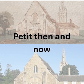
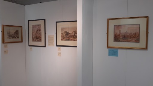
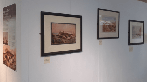
John Louis Petit – then and now

Introduction

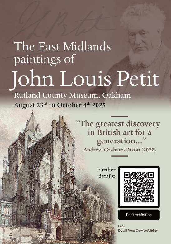
An Exhibition of the East Midlands paintings of John Louis Petit was held at Rutland County Museum from August to October 2025. During the preparation for that exhibition, I looked at whether the scenes that Petit painted were still recognisable today, and built up a collection of “then and now” photographs. Some of these have already appeared on various social media channels. In this post I show around 20 such comparisons and give brief notes as to locations and vantage points. Some of the modern photographs were taken by me, whist others were taken from publicly available sources. They are divided into the four sections used in the exhibition – Leicestershire and Rutland, Peterborough and Northamptonshire, Lincolnshire and Cambridgeshire and Further Afield. I hope they will be of interest to some readers.

(Click on the pictures for full view versions)

Leicestershire and Rutland

St. Mary de Castro, Leicester – JLP 1845, Author 2025. The obvious difference between the 1845 and the modern picture is the lack of a spire- this was removed for safety reasons in 2013.

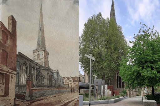
St Martin’s, Leicester – JLP 1845, Author 2025. St Martin’s became Leicester Cathedral in 1927 and has been considerably extended since Petit’s day, not least with the bones of Richard III. The 1845 view is now much obscured by trees and the new work.

St Luke’s, Thurnby – JLP 1845, Tim Glover, Creative Commons  license. Petit painted his picture in the period in the period the church was without its chancel. The church was substantially rebuilt in 1870 by Slater and Carpenter with a new chancel and south aisle.

St Mary’s, Melton Mowbray – JLP 1850, Author 2025. Obtaining the modern picture required sitting on the ground at low level in a car park. One hopes the ground level was different in Petit’s day. There are some interesting differences between the pictures – specifically a door in the right hand aisle in Petit’s picture, and one in the left hand aisle in the modern picture – perhaps as a result of the restoration by Scott of the 1860s and 70s?

Kirby Muxloe Castle – JLP 1845, Ashley Dace 2010, Creative Commons license. The pictures are from very similar vantage points, and show little difference in the tower.

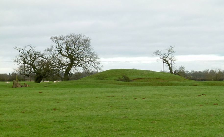
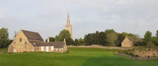
Oakham Castle and All Saints Church – JLP 1850, Author 2024. Both pictures are from the same vantage point. The major difference between them is the extent of the outbuilding on the right hand side.

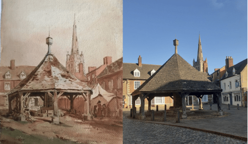
Oakahm Buttercross – JLP 1850, Author 2024. Again the pictures are from very similar, but not identical positions – the position from which Petit painted is now behind a hedge in the Oakham School grounds. The house roof lines and windows in the background are very similar. The building on the right hand side in 1850 has been replaced by the Sorting Office in the modern photograph.

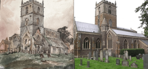
St Peter and St Paul, Exton – JLP 1845, Author 2024. The locations of the two pictures are similar but not identical – to achieve Petit’s position would have required climbing over a fence and a boundary between the churchyard and the Exton Estate of the Gainsborough’s. The photograph was taken from very close to the church and significant perspepctive correction was required.

Peterborough and Northamptonshire

St Andrew’s, Northborough – JLP 1841, J Haywood, Creative Commons Licence 2025. The Petit line drawing is from his book “Remarks on Church Architecture” from 1841. The two views are very similar

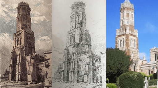
St Peter’s, Irthlinborough – JLP 1830,1841, Discover Northampton 2025. The line drawing is again from “Remarks on Church Architecture”, and was drawn for the 1830 painting. The tower in the modern picture shows the results from a major rebuild in the 1890s.

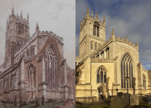
St Mary’s, Higham Ferrars – JLP 1830, Bearas 2024, Creative Commons license 2025. The major change here is to the chancel which was substantially rebuilt with a lower roof in the 19th century.

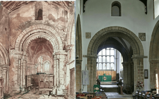
St Kynerburghia, Castor – JLP 1845, Alan Murray-Rust, Creative Commons license 2016. Both painting and photograph are from a position below the central tower. Petit’s painting shows a much more cluttered interior in the chancel area – possibly indicating an Elizabethan communion room arrangement.

Peterbrough Cathedral North Aisle – JLP 1845, Author 2024. The modern picture shows the location of the tomb of Catherine of Aragon. This was behind the screen that fills the aisle in the 1845 painting.

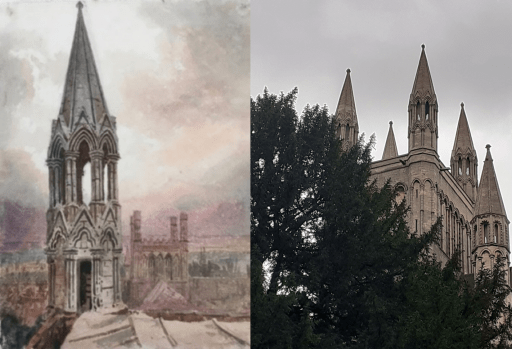
Peterborough Cathedral North Tower Pinnacle – JLP 1845, Author 2025. Petit painted the pinacle on the north tower from a location on the roof of the tower itself. It is looking east along the nave and chancel. I had neither the access or the inclination to get to the same vantage point, so the modern photo is from ground level, looking west from the side of the north aisle.

Lincolnshire and Cambridgeshire

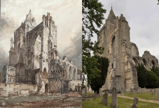
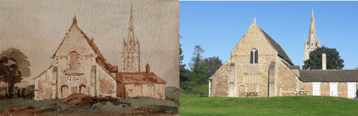
Crowland Abbey – JLP 1845, Author 2025. The location of the 1845 picture, possibly one of Petit’s most impressive, is now in the midst of a clump of trees, so the modern picture is from a slightly different location. The tree growth around the Abbey is significant.

South Kyme – JLP 1845, British Express 2025. The vantage points of both painting and photograph are very similar – and the tower has changed little in the interim.

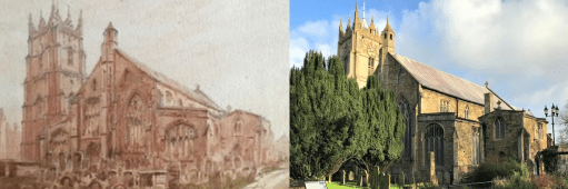
St Peter and St Paul, Wisbech – JLP 1845, BBC 2023 (after Geograph/Richard Humphrey). Another case of significant tree growth obscuring the view that Petit painted.

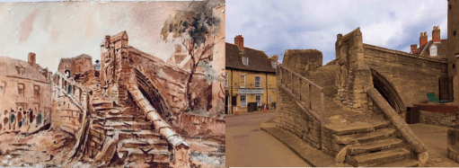
Crowland Trinity Bridge – JLP 1861, Author 2025. I managed to take the photo of Trinity Bridge in Crowland from almost the exact position from which Petit painted it and it can be seen the bridge is little changed. However Petit did not have to contend with cars and lorries wanting to occupy the same space.

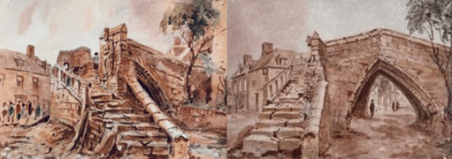
Crowland Trinity Bridge – JLP 1861 (x2). Finally I include a comparision of two pictures of Trinity Bridge in Crowland, almost certainly painted on the same day from slightly different vantage points. The right hand picture has recently been sold on eBay and is a screen shot from that site. The very similar representations of detail is astonishing, showing the accuracy of Petit’s representations.

Further afield

Both of these pictures are not really “then and now” – more “then and then” – and show the view that Petit painted against other historical views.

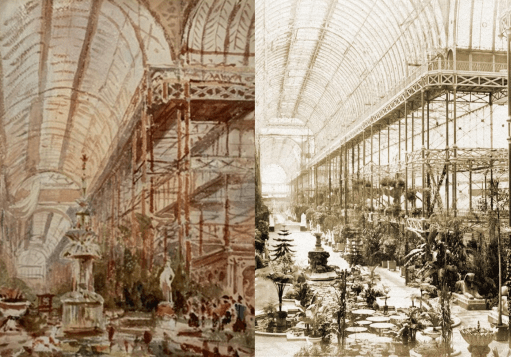
Crystal Palace – JLP 1867, Historic England 1859. The views are from similar vantage points, but show different exhibits in the same space. Comparing Petit’s painting of the superstructure with the photograph shows the accuracy of his representation.

Locmariaquer – JLP 1851, Postcard c 1900, Cartorum, Jules Coignet 1836, Public Domain. Petit painted his view of the dolmen at Locmariaquer in 1851. The painting by Jules Coignet is 15 years earlier, and the postcard view around half a century later. The similarities is in the rock formation in all three are striking, indicating again something of the accuracy with which Petit painted.

Closing Remarks

Perhaps the major point to emerge from this exercise for me is how Petit seems to have painted views from vantage points that were difficult to access, or from locations that most others would not have chosen. There are many churches for which I have not been able to make a comparison of Petit’s picture with the modern day situation, simply because there seem to be no published photographs from the location Petit used. He seems to have sought out the unusual viewing points.

Links

A Choral Evensong to celebrate the work of John Louis Petit as a clergyman and theologian

All Saints Church in Oakham October 5th 2025

John Louis Petit was an Anglican clergyman, ordained deacon in 1825 and priest in 1826, both at Lichfield Cathedral. He served two curacies – the first from 1825 to 1828 at St. Michael’s Lichfield and the second from 1828 to 1832 at Bradfield in Essex. He then retired from parish ministry to concentrate on his artistic and architectural interests. He remained a priest however, and was much interested in the theological developments of the mid-19th century – in particular the revelations of the earth and astronomical sciences. At his death he left a long unfinished poem “The lesser and the greater light” that was a meditation of the relationship between theology and science, which was edited and published by his sister. This poem has many contemporary echoes and reveals that Petit was a serious theological thinker.

To celebrate and reflect on Petit’s role as a clergyman and theologian, a Choral Evensong was held at All Saints church at 6.00pm on Sunday October 5th with the service sung by the Laudamus (Oakham Team Ministry) choir. The choral setting and hymns reflected Petit’s period and an address was delivered by Revd. Professor Chris Baker on the subject matter of “The lesser and the greater light” and its implications for both the Victorian period and for today. All Saints church was itself heavily restored by Gilbert Scott in the 1850s.

In this post we gather together some material associated with the event – the advertising poster, a copy of The Lesser and the Greater Light, the Order of Service and a transcript of the address.

Evensong flyer
The Lesser and the Greater Light (from Google Books)
Evensong Order of Service
Transcript of the address

Links

An exhibition of John Louis Petit’s East Midlands paintings

Rutland County Museum, Oakham, August 23rd to October 4th, 2025

During his career Petit painted many thousands of pictures, but his work was never sold, and after his death in 1868, they were passed on to relatives. A century later they were discovered in an attic in Surrey, dumped in auctions and were widely scattered. Only now is their artistic merit and historical value being recognised. The art critic Andrew Graham-Dixon the greatest re-discovery in British Art for a generation, and the first book about his art, by the chairman of the Petit Society, describes him as Britain’s lost pre-impressionist. Petit’s art of the East Midlands is part of this re-discovery. Close to his home base in Lichfield, Petit visited and painted across the region many times. Often, he paints locations and subjects no other historical artist touched. Some 40 of these pictures were gathered together to be shown to the public for the first time ever at an exhibition held in Rutland County Museum between August and October 2025.

In this blog post we gather together a range of material related to the exhibition – the advertising material and display boards; photographs of the exhibition area itself; and the exhibition catalogues and slideshow that was shown on the screen in the exhibition area.

Exhibition flyer and display boards

Exhibition flyer
Exhibition display boards

The flyer formed the basis of advertising the exhibition and was widely distributed by email and Social Media, with a small number of hard copies distributed locally around Oakham. There were five display boards – a general introduction (A1) and four others relating to the four geographical sections of the exhibition – Leicestershire and Rutland, Northampton and Peterborough, Lincolnshire and Cambridgeshire and Further Afield (A2).

The Exhibition

Catalogue and slide presentation

The simply produced catalogue contained brief details and a small photos of all the pictures that were planned to be exhibited. In the event a small number were not hung due to space limitations. These were shown as a slide presentation on a screen in the exhibition area, together with pages from an 1830 Album (see catalogue for description) and a selection of other East Midlands paintings.

Exhibition Catalogue
Slide show

Acknowledgements

The contributions of the following groups of people to the success of the exhibition need to be mentioned – the sponsors who provided much needed financial support; those friends of the organisers who helped with transport, mounting pictures and catering at the opening event; those who loaned paintings that were shown (identified in the catalogue); and most importantly the staff at Rutland County Museum for making the exhibition space available and constructing the exhibition. The help of all of them is very gratefully acknowledged.

Links

An ancient solar alignment in Oakham?

Preamble

In a post “A possible Anglo-Saxon church group at Oakham in Rutland” from May 2024, I noted that All Saints Church in Oakham, and Our Lady’s Well to the north east were on what could be a mid-summer sunrise / mid-winter sunset solar alignment. I went no further than simply noting this, and didn’t speculate further about what it might imply. One always needs to be cautious about such alignments – they can be simple coincidences, and, if they are being looked for, can be found in the most unlikely places. For example from Borrowcop Hill in Lichfield, possibly an ancient burial mound, there was until recently a perfect alignment with the medieval spires of Lichfield Cathedral and the cooling towers of Rugeley power station, the latter sadly now demolished, which can hardly be of ancient origin. That being said, a reader of the May 2024 post sent me some further information that suggests that a cluster of Stone Age / Bronze Age / Iron Age remains have been found to the north east of Our Lady’s well that could also be on the same alignment. Looking at this further, I realised that several kilometres to the north east of that, and again on much the same alignment, we have Alstoe Mount, another historic monument. These are all shown on the Ordnance Survey map extract of Figure 1 below. The nature of this possible alignment, along the axis of the mid-summer sunrise and mid-winter sunset is discussed further in this post.

Figure 1. The possible alignment. The sites are shown as red circles – from the south west to the north east these are All Saints church in Oakham, Our Lady’s Well, the historic monuments and Alstoe Mount.

The sites

All Saints church, Oakham

All Saints Church is Oakham (Figure 2) is a twelfth century church with thirteenth to fifteenth century additions. Internally it is pure Victorian, having been restored by Gilbert Scott. However it almost certainly stands on the site of an Anglo-Saxon church, and a church in Oakham is mentioned in the Domesday book. A compendium of historical information is given on the church website.

Figure 2. All Saints Oakham and Oakham Castle (photograph by the author)

Our Lady’s Well

Our Lady’s Well is a historically well-attested pilgrim site to the north east of All Saints church – see Figure 3. To quote from Leicestershire and Rutland’s Holy Wells by Bob Trubshaw from 2004;

Our Lady’s Well was once famed for curing sore eyes – providing that a pin was thrown in first. In 1291 indulgences could be obtained by visiting Oakham Church during its patronal festival and, for a price, joining a pilgrimage to Our Lady’s Well. In 1881 it was visited by the future Queen Alexandra. The well is to the north-east of the town, in a somewhat overgrown area between the Cottesmore road and a modern housing estate (NGR SK:866095).

It’s current condition is no better, and it is now impossible to access the well, in an overgrown plot of wasteland, which seems a shame.

Figure 3. Location of Our Lady’s Well from the 1880 Ordnance survey Map (All Saints church is at the bottom left, and the well at the top right.)

The Stone Age / Bronze Age / Iron Age monuments

The material I was sent concerning the Stone Age / Bronze Age / Iron Age monuments came from “Land off Burley Road Oakham, Vision and Delivery Document” produced by Pigeon Investment Management with regard to a proposed hosing development. Figure 4 is taken from that document and shows the location of Our Lady’s Well and the relevant monuments.

Figure 4. The Stone Age / Bronze Age / Iron Age monuments (from Land off Burley Road Oakham, Vision and Delivery Document)

The monuments are listed as follows, where the numbers are those on the Historic England National Heritage list.

MLE5587 – Possible Mesolithic site west of Burley Road
MLE5592 – Late Iron Age/Roman site west of Burley Road
MLE5593 – Bronze Age burial, west of Burley Road
MLE5594 – Neolithic pit circle site west of Burley Road

Alstoe Mount

The substantial mound of Alstoe Mount (Figure 5) is described on the Ordnance Survey map as a Motte and Bailey. That is almost certainly not true. It was probably the Moot location for Alstoe Hundred. Details of the mound and the surrounding deserted village are given in the Historic England list entry.

Figure 5. Alstoe Mount (photograph from Historic England by Alan Murray-Rust, 2016)

The possible solar alignment

A current mid-summer sunrise / midwinter sunset direction from Oakham is 47.5 degrees east of north (from SunCalc). However obtaining a precise value to compare with the possible alignment shown in Figure 1 is difficult for two reasons. Firstly the actual direction of sunrise and sunset has varied over the millennia – and as things stand, we have no date for which a calculation can be made. This change is however small – of the order of 0.2 to 0.5 degrees. Also the apparent direction from any point depends upon the precise topography of the horizon over which the sunrise / sunset is observed – and as we know nothing about the observation point or the direction of observation, this is again not possible to specify. This again results in an uncertainty of around 0.5 degrees. So all we can probably say is that we are looking for an alignment of 47.5 +/-1.0 degrees east of north.

The actual directions between All Saints Oakham and the other sites is as follows.

Oakham to Our Lady’s Well – 46.3 degrees
Oakham to Stone Age / Bronze Age / Iron Age monuments – 47.1 degrees
Oakham to Alstoe Mount – 47.8 degrees

Again there is uncertainty here – particularly in the specification of the precise site at Our Lady’s Well of any structure that might have been visible from All Saints, and similarly the precise position of any relevant structure in the monument field. The location point for All Saints (taken as the centre of the building) could be around 10m to the east or west. This can have an effect of the bearings of Our Lady’s Well and the monuments by around 0.25 degrees. Considering these uncertainties the above bearings and a sunrise / sunset direction of 47.5 degrees seem broadly consistent, and thus there does seem to be some evidence for all four sites lying along a solar alignment of some significance.

But there is another issue – that of elevation. A cross section along the proposed alignment is shown in Figure 6. From this it is clear that Alstoe Mount would not be visible from Our Lady’s Well or from the Monument field, and would only just be visible from All Saints if any observation platforms that existed there and at Alstoe were raised off the ground by a metre or so. Beacons however would have been visible.

Figure 6. Section through the proposed alignment (from Google Earth Pro.).

Discussion

So what does the above analysis lead to. Firstly I think there is plausible (but far from conclusive) evidence for a mid-summer sunrise / mid-winter sunset alignment, at least between the Monument field / Our Lady’s Well and All Saints, and possibly between Alstoe Mount and All Saints. but the available evidence gives us no chronological information as to when the alignment might have been of significance. Our Lady’s Well is first mentioned in the late Middle Ages and All Saints and Alstoe Mount can only be said to become of important in the pre-conquest period. There is no evidence at all, except in the monument field, for the other sites being important in the Stone Age / Bronze Age / Iron Age. So in my view it is probably better to stop at this point – acknowledging that there may be a solar alignment, but not taking speculation any further. The boring, cautious approach I guess, but I don’t think there is much more to be said.

A cross country experience

Preamble

For family reasons, I often make the journey from Oakham to the Chesterton area of Cambridge, travelling by train from Oakham station to Cambridge North, changing at Ely, and then either walking or taking one or more buses to reach my destination. The last leg is actually quite time consuming, and adds considerably to the overall travel time. Now in July 2025, I learnt of the existence of a new bus service from Huntingdon to Fenstanton and then along the Cambridge Busway, through Chesterton to Cambridge, passing very close to my destination (the Whippet Coaches T1). This seemed to me to offer an interesting, and potentially quicker journey, travelling to Peterborough by Cross Country trains, then to Huntingdon on Thameslink, and then onto the bus to my final destination. What follows is a report on the journey there and back via this route, highlighting both its good and bad points.

The journey

I trevelled to Cambridge very early on a Saturday morning, catching the 5.47 East Midlands Trains service from Oakham to Peterborough, and then, after a 9 minute connection, the 6.24 Thameslink service to Huntingdon. The connection was straightforward, although there was some conflict between the online information and what actually happened on the ground with regard to the platforming of the Thameslink train at Peterborough. I arrived at Huntingdon on time at 6.38.

Now the weather that day was “interesting” to say the least, as can be judged from the weather radar screen shot below (Figure 1). The T1 was due to leave the station at 7.19, so I was anxious to find somewhere dry to wait. On leaving the Huntingdon station buildings, I found a convenient bus turning circle, with a respectable shelter (Figure 2). The only problem was that this was obviously not in use, and I was directed to a bus stop on the side of the ring road outside the station, which had no facilities other than a bus lay by and a stop sign (Figure 3). Why this change had occurred I have no idea – presumably something to do with operational convenience – but it had nothing to do with the comfort and convenience of passengers. Not good.

I was not anxious to wait to get soaked in such a situation, so I followed the signs to Huntingdon Bus Station, about a 5 to 10 minute walk away (including crossing the ring road) where the T1 was due to call after the railway station. This was a perfectly acceptable facility, with covered seating and adequate information – the only problem was that it wasn’t at the railway station (Figure 4).

The bus arrived precisely on time. The driver was cheerful and efficient and everything ran smoothly. the bus ran non-stop to Fenstanton, then travelled quite slowly over some minor roads (with cars very dubiously parked) to the Busway at Swavesey. From there the trip was fast and smooth along the busway. The weather by this time was horrible as can be seen from figures 5 and 6. Loadings were light throughout, perhaps because it was a wet Saturday morning. It left the Busway at Milton Road in the north of Cambridge, and stopped at a number of stops along that road (unlike the standard Busway buses that run limited-stop into the city centre). I arrived at the stop I wanted a little after 8.00. The journey time was about 2 hours and 20 minutes, even with the 40 minute sojourn in Huntingdon. That was about the same time that the journey would have taken by train to Cambridge North. It was however rather cheaper, partly thanks to my Bus Pass!

The return journey was uneventful, except for the weather. Around about Fenstanton, the persistent rain became a deluge which persisted until after the bus arrived at Huntingdon. The drop off in the layby outside Huntingdon station and the walk into the station building was unpleasant to say the least. I got on the bus at around 12.30 and arrived back at Oakham at 14.20 – half an hour quicker than the outward journey thanks to good connections in Huntingdon and Peterborough.

Reflections

So what was my overall view of the journey. The T1 bus service itself was very pleasant and convenient and Whippet Coaches are to be congratulated. The journye times and stopping places suited me very well. The service has the potential to be more than just a local service and could have a more inter-urban role, if the connections into the rail network were better. The hourly service inevitably means some extended connection times at Huntingdon and / or Peterborough and a more frequent service would be nice, although whether this would be financially viable is perhaps doubtful.

The unpleasant part of the journey was the lack of proper bus connection facilities at Huntingdon station. It is difficult to see how this could have been made worse, and is a classic example of the neglect of the most basic principle of integrated transport. Whoever is responsible (Cambridgeshire County Council perhaps?) should hang their heads in shame.

St Michael’s Lichfield blogs – a compilation

A compilation of some of my blog posts from the past few years about St Michael’s church in Lichfield.

Saddlebacks and serendipity. A brief post that identifies the occupant of the notable Saddleback grave in St. Michael’s churchyard (3rd January 2025)

The changing face of death. A blog post introducing a statistical analysis of the interment records and monuments of St Michael’s churchyard in Lichfield from 1813 to 2012, looking at the changes in funerary patterns over that period. (February 24th 2023)

100th Anniversary of the dedication of the choir vestry at St Michael’s church in Lichfield. A short blog post describing the occasion in 1923 (February 19th 2023)

The Churchyard at St. Michael’s, Lichfield – registers and records. An introduction to the web pages of the same name that collate a range of information from memorials and burial registers at St Michael’s from 1813 to 2012 (November 15th 2022)

James Jordan Serjeantson – Rector of St. Michael’s church in Lichfield, 1868 to 1886. This takes material from earlier blog posts and appeared as an article in the February 2022 edition of the Parish Magazine. (January 3rd 2022). Updated with information from the British Newspaper Archive in January 2023.

The seventeenth century graves of St Michael’s churchyard. A brief examination of some of the older grave monuments in the churchyard of St. Michael-on-Greenhill in Lichfield (June 10th 2021)

The St. Michael Chalice of 1684. A very brief blog post with a photograph of a 1684 communion chalice from St Michael’s Lichfield, sold in the 1850s to pay for something more modern. (December 30th 2020)

For some more similar posts  see https://profchrisbaker.com/historical-studies/lichfield-history/  

For links to my four part e book which contains most of the above material, and much else, go to https://profchrisbaker.com/historical-studies/st-michael-on-greenhill-lichfield-a-history-the-ebook/

All Saints Oakham blogs and presentations – a compilation

Some summer reading and viewing – a compilation of some of my recent blog posts and a presentation on the history and heritage of All Saints church in Oakham.

Blog posts

The memorials of All Saints Oakham. Photographs and brief descriptions of the wall mounted memorials at All Saints church in Oakham (May 19th 2025)

From Oakham to Mandalay. The story of a young curate from Oakham and his brief service as a missionary in Burma before his early death (April 29th 2025)

Kinetic Water Power – some odd words on a memorial in All Saints Oakham led to some interesting findings about how church organs were powered at the start of the 20th century (25th April 2025)

The Harrington Bequest. Two posts that consider the bequest of Anne, Lady Harrington in 1616. Part 1- The charityPart 2 – Oakham Parish Library (31st March 2025)

The chancel and chapels of All Saints church Oakham – Gilbert Scott’s legacy. A post looking at some aspects of the restoration of All Saints Oakham in 1858 (November 5th 2024)

A time to mourn, and a time to dance – the All Saints season through the ages. The recording and transcript of a  talk given at All Saints Oakham on 31/10/24  (November 3rd 2024)

The 1858 Restoration of All Saints church in Oakham. Part 1Part 2, Part 3 Three linked posts giving the transcripts of press reports of the restoration and re-opening of All Saints church in 1858, including the condition report by Gilbert Scott (October 9th 2024)

The good, the bad and the grotesque – the decorated capitals of All Saints church in Oakham. An examination of some wonderful medieval stone carvings in Oakham Parish Church (3rd February 2024)

For more see https://profchrisbaker.com/ecclesiastical-studies/ecclesiastical-blog-posts/

Presentation

A time to mourn and a time to dance. A time to mourn and a time to dance – the All Saints season through the ages. The video of a talk given at All Saints Oakham on October 31st 2024

Oakham and Rutland blogs – a compilation

For some summer reading – a compilation of some of my recent blog posts on ancient and more modern Oakham and Rutland history.

The street topography of early Oakham. A post that considers how the street of Oakham and the surrounding areas might have been configured in the Anglo-Saxon and Norman periods (December 8th 2024)

Public Transport in Oakham from the 1960s to the present. A blog that looks how road and rail transport in and through Oakham has developed and degraded over the last 60 years. (November 15th 2024)

Oakham roofs. A photo blog simply showing the upper floors and roofs of the buildings on the north side of the High Street in Oakham. For no other reason than I like roofs. The history is implicit rather than explicit (July 23rd 2024)

Commemorating the 1000th Anniversary of the birth of Queen Edith. An address / sermon delivered by me at All Saints Oakham on March 10th 2024, at a Choral Evensong during the Queen Edith Festival (11th March 2024)

Rutland – an enigmatic history – a further speculative consideration of three oddities about the early history of Rutland (2nd February 2024)

Rutland and the Hwicce Some further thoughts on the County of Rutland and its association with the Hwiccan tribe of Worcestershire and Gloucestershire (30th December 2023)

The Origin of Rutland – some speculations on the early history of the area where I now live (2nd December 2023)

For more see https://profchrisbaker.com/historical-studies/rutland-history/

Railway blogs – a compilation

Summer reading for those interested in the early railways around Dudley.

Dudley and its Railways in 1868. A post describing the extensive rail services around Dudley in 1868 (August 25th 2024)

The Pensnett Canal and the Pensnett Railway – a post discussing how the beginnings of these two concerns were tied up together (September 21st 2022)

Kingswinford Junction 1949. A post describing the train movements through and around Kingswinford Junction in the Black Country and the associated marshalling yard in 1949, just post-nationalisation. (April 15th 2021)

The OWWR Kingswinford branch 1854. A post based on a set of drawings that showed proposed changes to an OWWR branch line before it had been built, possibly to accommodate the travel needs of Baron Ward, and incidentally gives early information about the layout of Oak Farm Iron Works (April 14th 2021)

The Earl of Dudley’s Railway – Accidents and Incidents Using material taken from a search of newspapers between 1830 and 1920, this post looks at the sort of accidents that occurred on the Pensnett Railway to both railway workers and those who lived close by, and at the nature of crime on and around the railway. (May 19th 2020)

The railways of Shut End and Corbyn’s Hall A detailed look at the industrial railways within and around the iron works at Corbyn’ Hall and Shut End. (March 2nd 2020)

And finally, something more modern from a little further afield.

The Cross City Line – 1962 to 2024, which looks at the development of the service on the Cross city Line in the West Midlands between the early 1960s and the present day (February 1st 2025)

Lichfield history blogs – a compilation

Some summer reading – a compilation of a few of my blog posts about the history of Lichfield.

Lichfield – a pre-conversion pagan cultic centre? A post that considers the early history of the city of Lichfield, and argues that it might have been a place of cultic significance before the Christian era. Some of this is very speculative, but may be of interest

A study of the ancient prebends of Lichfield Cathedral. A post that uses information from the Staffordshire tithe maps in an attempt to recreate the early geography of the Lichfield area. (August 12th 2020)

“That way madness lies” – the search for solar alignments in Lichfield The city of Lichfield lies on a rough midwinter solar alignment with the Bronze Age site at Catholme. This post investigates this further to see if this alignment is intentional or merely accidental. (April 12th 2020)

Lichfield’s First Station Master. A post that looks at the career of Lichfield’s first Station Master and church warden of St. Michael’s, William Durrad. (January 15th 2021)

Lichfield Trent Valley 1847-1871. A look at one the earliest railway stations in the Lichfield area. (September 28th 2020)

For other similar posts see https://profchrisbaker.com/historical-studies/lichfield-history/